Kahramanmaraş
Kahramanmaraş is a city and provincial capital in southern Turkey, known for its distinct ice cream, historical background, and regional industry. It was named 'Kahraman' for its role in Turkish history.
Overview
Kahramanmaraş is a city and the administrative center of Kahramanmaraş Province in southern Turkey. Situated in the eastern part of the Mediterranean Region, the city lies at a transition zone between coastal lowlands and the Anatolian interior. In 2013, 1,075,706 people lived there. Kahramanmaraş combines urban and rural districts and serves as a regional hub for commerce, education and transport. For general reference see the city page and information about Turkey.
Image gallery
10 Images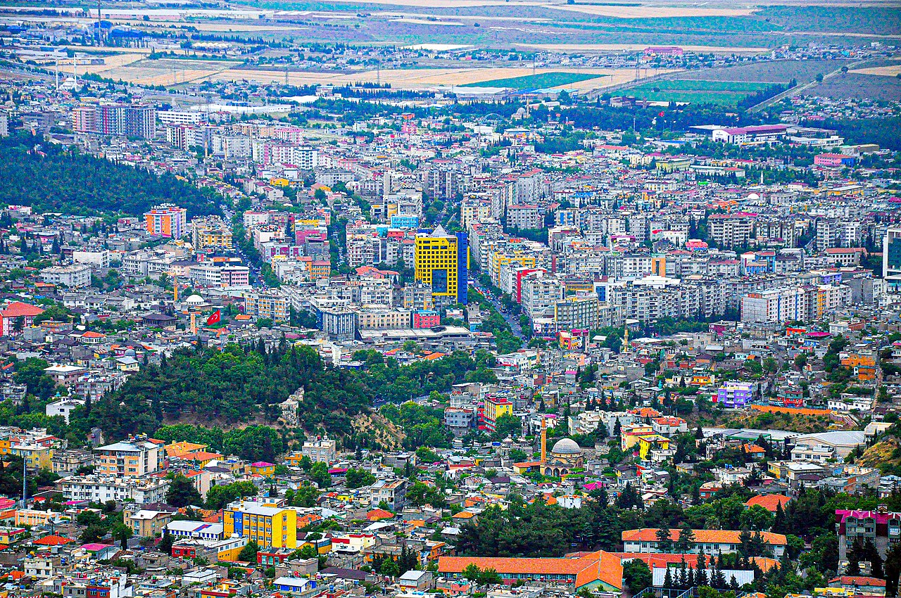


Historical background and name
Human settlement in the area dates back millennia and the region has been ruled at various times by Hittites, Romans, Byzantines, Armenian principalities, Seljuks and Ottomans. The modern city was long known simply as Maraş. In recognition of local resistance during the Turkish War of Independence, the Turkish Grand National Assembly granted the city the honorific title "Kahraman" (meaning "heroic"), producing the present name Kahramanmaraş.
Characteristics and culture
The city is noted for several cultural and culinary traditions. Most famous is Maraş dondurması, a thick, chewy ice cream traditionally made with salep and mastic; it is both a local product and a cultural symbol. Handicrafts such as copperware and woven textiles reflect long-standing artisan skills. The urban fabric mixes Ottoman-era mosques and bazaars with modern commercial districts.
Economy and uses
Kahramanmaraş has a diversified regional economy. Agriculture in surrounding districts produces crops and raw materials that feed local processing industries. The city also hosts textile manufacturing, food processing and small-scale heavy industry. As a provincial capital it provides government services, higher education institutions and healthcare for the wider region.
Notable facts and recent developments
- Name distinction: "Kahraman" was appended to honor its wartime role and distinguishes it from other places historically called Maraş.
- Culinary fame: Maraş ice cream is recognized across Turkey and abroad for its texture and traditional preparation.
- Recent events: The province and city were among areas affected by the earthquakes that struck southeastern Turkey and adjacent regions in 2023, with significant impact on infrastructure and communities.
Kahramanmaraş remains an important regional center where history, culinary tradition and industrial activity meet. For further reading and official resources consult local authorities and national overviews via city resources or broader guides at country-level information.
Geography
Geographical position
Kahramanmaraş is located at an altitude of 549 m in the western foothills of the Taurus Mountains, on the edge of a fertile plain on the southern slope of Ahirdağ, near the southern connection to three important passes. The surrounding region is mountainous and has rich mineral deposits, mainly iron and silver. 20 km to the east is the Ayvalı Dam.
Management
With Law No. 6360, enacted in December 2012, the central county (Merkez Ilçe) with the provincial capital Kahramanmaraş was divided into two counties or belediye, so that the city de facto no longer existed: Onikişubat in the east and Dulkadiroğlu in the west.
- Onikişubat received 17 of the 74 villages (Köy), 47 of the 90 mahalle of the provincial capital and the following ten belediye:
· Donengele
· Fatih
· Fatmalı
· Ilıca
· Kale
· Karadere
· Kürtül
· Önsen
· Şahinkayası
· Tekir
- Dulkadiroğlu received 57 villages, 43 mahalle and the Belediye Baydemirli.
Through the subsequent administrative reform, the units in both counties/belediye/districts were merged and transformed into mahalle, headed by a muhtar as the chief official.
Climate table
| Kahramanmaraş | ||||||||||||||||||||||||||||||||||||||||||||||||
| Climate diagram | ||||||||||||||||||||||||||||||||||||||||||||||||
| ||||||||||||||||||||||||||||||||||||||||||||||||
| Monthly average temperatures and precipitation for Kahramanmaraş
Source: State Meteorological Office of the Turkish Republic, Normal Period 1981-2010 | |||||||||||||||||||||||||||||||||||||||||||||||||||||||||||||||||||||||||||||||||||||||||||||||||||||||||||||||||||||||||||||||||||||||||||||||||||||||||||||||||||||||||||||||||||||||||||||||||||||||||||||||||||||||||||||||||||||||||||||
History
Ancient
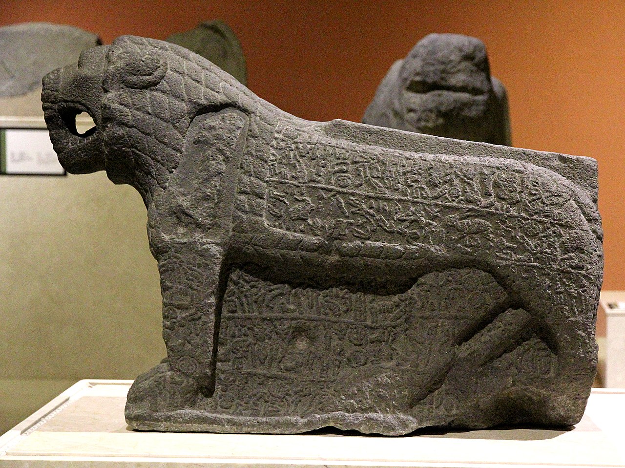
Mar'as (Marqas) was the capital of the Neo-Hittite kingdom of Gurgum in the Iron Age. When the Assyrians conquered the kingdom in 711 BC, Marqas became the provincial capital and seems to have remained so until the end of the Assyrian Empire.
The Roman Emperor Caligula renamed the city Germanicia Caesarea after his father Germanicus. This name was used under the Byzantines as Germanikeia. The Crusaders called the city Sebastia.
The Arabs conquered the city around 645 and used it as a base for incursions into Asia Minor. Destroyed several times during the Arab-Byzantine-Armenian battles, the city was rebuilt by the Umayyad caliph Muʿāwiya I (7th century) and expanded around 800 by the Abbasid caliph Hārūn ar-Raschīd.
Middle Ages
From 1071, Maraş became the governmental center of Philaretos Brachamios, who created his own power base in the southeast of the Byzantine Empire after the defeat of Emperor Romanos IV Diogenes in the Battle of Manzikert around 1071. His territory included Antioch and Edessa. After the death of Philaretos, his officer Tatul took over the rule in Maraş and was recognized by Emperor Alexios I.
The crusaders of the First Crusade briefly occupied Maraş around 1097, and Balduin I of Jerusalem conquered Maraş in 1103 and incorporated it into the principality of Antioch. In 1114 the city was destroyed by an earthquake; according to the chronicle of Matthias of Edessa, 40,000 people were killed, which is probably an exaggeration. The effects of the catastrophe were felt as far away as Sis. In 1135, the Danishmanids unsuccessfully besieged Maraş. In 1146, Balduin of Maraş fell while attempting, alongside Joscelin II, to retake Edessa against Nur ad-Din. His successor Reinhold of Maraş fell in 1149 at the Battle of Inab, whereupon the dethroned Joscelin II, as Reinhold's brother-in-law, took power in Maraş, but fled in 1150 from the attack of the Rum Seljuks under Sultan Mas'ud I, who subsequently captured the city. Apparently, the city later passed to Nur ad-Din, who gave Maraş to Prince Mleh of Lesser Armenia in 1171 in exchange for a high-ranking Byzantine prisoner.
When the Small Armenian Empire was crushed by the Egyptian Mamluks in the 14th century, Maraş came under the rule of the Dulkadir before the city became part of the Ottoman Empire under Sultan Selim I around 1515.
At the end of the 19th century, the city was located in the Vilâyet Aleppo and was the capital of a sandshak. It made a grand impression at that time, had 25 mosques, several Armenian churches, numerous public baths and 10,000-15,000 inhabitants, many of them Armenians. Among the craftsmen the Turkish red (kermes) dyers, weavers and comb makers stood out.
20th century
In 1919, French troops occupied the city of Maraş along with the surrounding province. The resistance against the occupiers was initiated by the scholar Sütçü İmam, it spread quickly and the insurgents were able to defeat the French. Many citizens died in the process, to which a place called Kanlıdere (Engl.: "Bloody Brook") bears witness to this day. Maraş was awarded the honorific name Kahraman (Engl.: "heroic") for the resistance in 1973. The victory there over General Gouraud's French battalions motivated Turkish fighters in all parts of the country to resist the occupying forces. This was followed by the capture of Urfa and Antep, which were given the honorary names Gaziantep (Eng: "victorious Antep") and Şanlıurfa (Eng: "glorious Urfa"). Kahramanmaraş is the only city to have been awarded the İstiklâl Madalyası (Independence Medal), as the French were driven out by local forces in the city before the troops of the Kuvayı Milliye (Atatürk's militia) intervened.
The three-week battle for Maraş in 1920 was also accompanied by massacres of Armenians who had resettled in the region after the genocide. Turkish gangs threw kerosene-soaked rags at Armenian homes and laid down a barrage in front of the American Relief Hospital. Armenians sought refuge in churches and schools. Women and children found temporary shelter in the city's six Armenian Apostolic churches, three Armenian Protestant churches, and the only Catholic cathedral. The Armenian legionaries tried to defend them but were overwhelmed. All the churches and eventually all the Armenian neighborhoods were set ablaze. The fate of the Armenians worsened when the French decided to withdraw on February 10. When the 2,000 Armenians who had taken refuge in the Catholic Cathedral tried to follow the retreat, they fell victim to Turkish rifles and machine guns.
Initial reports put the death toll of Armenians at 16,000, which was later revised to between 5,000 and 12,000, which are now considered more reliable figures.
Pogrom of 1978
→ Main article: Kahramanmaraş pogrom
After several violent clashes and riots, two teachers were shot dead on December 21, 1978. During the funeral the next day, clashes broke out again and two people were killed. On December 23, supporters of the right-wing MHP party attacked Alevi residential neighborhoods in Kahramanmaraş. There were 31 deaths and 150 injured. Despite the deployment of additional army units to Kahramanmaraş on December 24, the groups could not be prevented from further attacks. The government imposed a state of emergency on the 13 provinces in southeastern Turkey. According to official figures, 111 people have died. According to unofficial statements of the local population, more than 1100 people were killed. The government cited a conflict between leftists and rightists as the motive for the attacks.
21st century
In December 2012, it was decided to station around 400 Bundeswehr soldiers in the city as part of Operation Active Fence from January 2013, who were to operate Patriot anti-aircraft missiles there due to the civil war in Syria. On December 30, 2015, the German contribution to Operation Active Fence ended with the withdrawal of the last soldiers.

Population (demography)
The population share of the two newly created belediye/İlçe in the Büyükşehir belediyesi:
| Region | 2020 | 2019 | 2018 | 2017 | 2016 | 2015 | 2014 | 2013 | 2012 |
| Dulkadiroğlu | 223.277 | 222.673 | 222.938 | 224.531 | 219.548 | 218.067 | 218.029 | 216.701 | norMerkez |
| Onikişubat | 441.681 | 431.848 | 418.379 | 407.956 | 396.753 | 384.953 | 371.394 | 357.870 | |
| Total | 441.681 | 431.848 | 418.379 | 407.956 | 396.753 | 384.953 | 371.394 | 357.870 | 558.664 |
| Share in % | 37,81 | 37,42 | 36,54 | 36,18 | 35,66 | 35,10 | 34,10 | 33,27 | 52,55 |
| Büyükşehir | 1.168.163 | 1.154.102 | 1.144.851 | 1.127.623 | 1.112.634 | 1.096.610 | 1.089.038 | 1.075.706 | 1.063.174 |
Until the Armenian Genocide beginning in 1915, numerous Armenian families lived in Maraş. Those survivors of the genocide who fled to Armenia founded the Nork-Marash (Turkish: Yeni Maraş) neighborhood in Yerevan.
Population figures according to censuses 1927 to 2000
The following table provides information on the development of the population figures of the city (Şehir), district (İlçe) and province (İl) of Ordu. The figures were taken from the results of the censuses of the indicated years published as PDF files, available from the library of the TURKSTAT (TÜİK) and from the census page of the (TÜİK) for the years 1965 to 2000 (only in Turkish).
| Year | 1927 | 1935 | 1940 | 1945 | 1950 | 1955 | 1960 | 1965 | 1970 | 1975 | 1980 | 1985 | 1990 | 2000 |
| Şehir | 25.672 | 29.402 | 27.744 | 33.104 | 34.641 | 42.962 | 54.447 | 63.284 | 110.761 | 135.782 | 178.557 | 210.371 | 228.129 | 326.198 |
| İlçe | 70.127 | 84.233 | 88.025 | 100.761 | 104.268 | 123.253 | 125.734 | 141.949 | 195.116 | 232.131 | 293.716 | 336.961 | 360.481 | 465.370 |
| 186.855 | 188.877 | 202.073 | 261.550 | 288.843 | 336.797 | 389.857 | 438.423 | 528.982 | 641.480 | 738.032 | 840.472 | 892.952 | 1.002.384 |
Economy and infrastructure
Traffic
A branch line connects Maraş with the Adana-Malatya train line. A rural road leads via Türkoğlu to the Otoyol 52 highway from Adana to Gaziantep. Kahramanmaraş Airport is served by Turkish Airlines daily from Istanbul and Ankara and private airline Pegasus-Airlines three times a week.
Education
Sütçü İmam University-Kahramanmaraş (Turkish: Kahramanmaraş Sütçü İmam Üniversitesi) was founded in 1992, it has been constantly expanding since its establishment and in 2007 it consists of seven faculties, ten vocational colleges, two technical colleges, three institutes, ten research centers, and six departments under the rectorate. There are four different campuses, with the completion of the most modern campus (Campus Avşar) still in progress.
Economy
The city is a center for industry and trade. Produced and exported are olive oil, spices and textiles. The city is one of the largest textile producing cities in Turkey. The main employers are large fabric mills, so the city is the leader of the Turkish textile industry. Another mainstay of the economy in Kahramanmaraş is the production of traditional ice cream. Carved furniture, as well as copper, silver and brass works are also valued. In the surrounding area, wheat, rice and pulses are the main crops grown, with the Ceyhan River serving to irrigate the fields.
Health
The city has several hospitals.
- Kahramanmaraş Ağız ve Diş Sağlığı Merkezi
- Sütçü İmam Üniversitesi Araştırma ve Uygulama Hastanesi
- Kahramanmaraş Necip Fazıl Şehir Hastanesi
- Kahramanmaraş Özel Hayat Hastanesi

Personalities
- Leon III. (c. 680 - 741), Byzantine emperor between 717 and 741.
- Sareh I (1915-1963), Catholicos of the Great House of Cilicia of the Armenian Apostolic Church.
- Berç Sahak Turan (1920-1997), Turkish architect and senator of Armenian origin.
- Vahit Kirişci (b. 1960), agricultural engineer, university professor and politician
- Şeref Eroğlu (* 1975), wrestler
Related articles
Author
AlegsaOnline.com Kahramanmaraş Leandro Alegsa
URL: https://en.alegsaonline.com/art/51892