
Aral Sea: history, collapse, environmental impacts and recovery efforts
Former Central Asian lake between Kazakhstan and Uzbekistan that largely dried up after Soviet irrigation projects; now a case study in ecological collapse and partial restoration.
Overview
The Aral Sea was a large inland body of water in Central Asia, lying between what is now Kazakhstan in the north and the Karakalpak region of Uzbekistan (Karakalpakstan) to the south. Local names reflect the region's languages: the Kazakh, the Uzbek and the Russian designations are all in common use. It was a large endorheic, or closed-basin, lake that supported fisheries, local climates and human communities for centuries.

Image gallery
10 Images


Geography and characteristics
Fed primarily by the Amu Darya and the Syr Darya rivers, the Aral Sea's waters were relatively saline and variable seasonally. The lake's size and depth fluctuated with river inflow and climate. Islands and peninsulas in the basin included Vozrozhdeniya (Rebirth Island), once isolated but later connected to the mainland as water levels fell. The basin's soils, sediments and weather patterns were shaped over millennia by the presence of the lake and its wetlands.
Causes of the decline
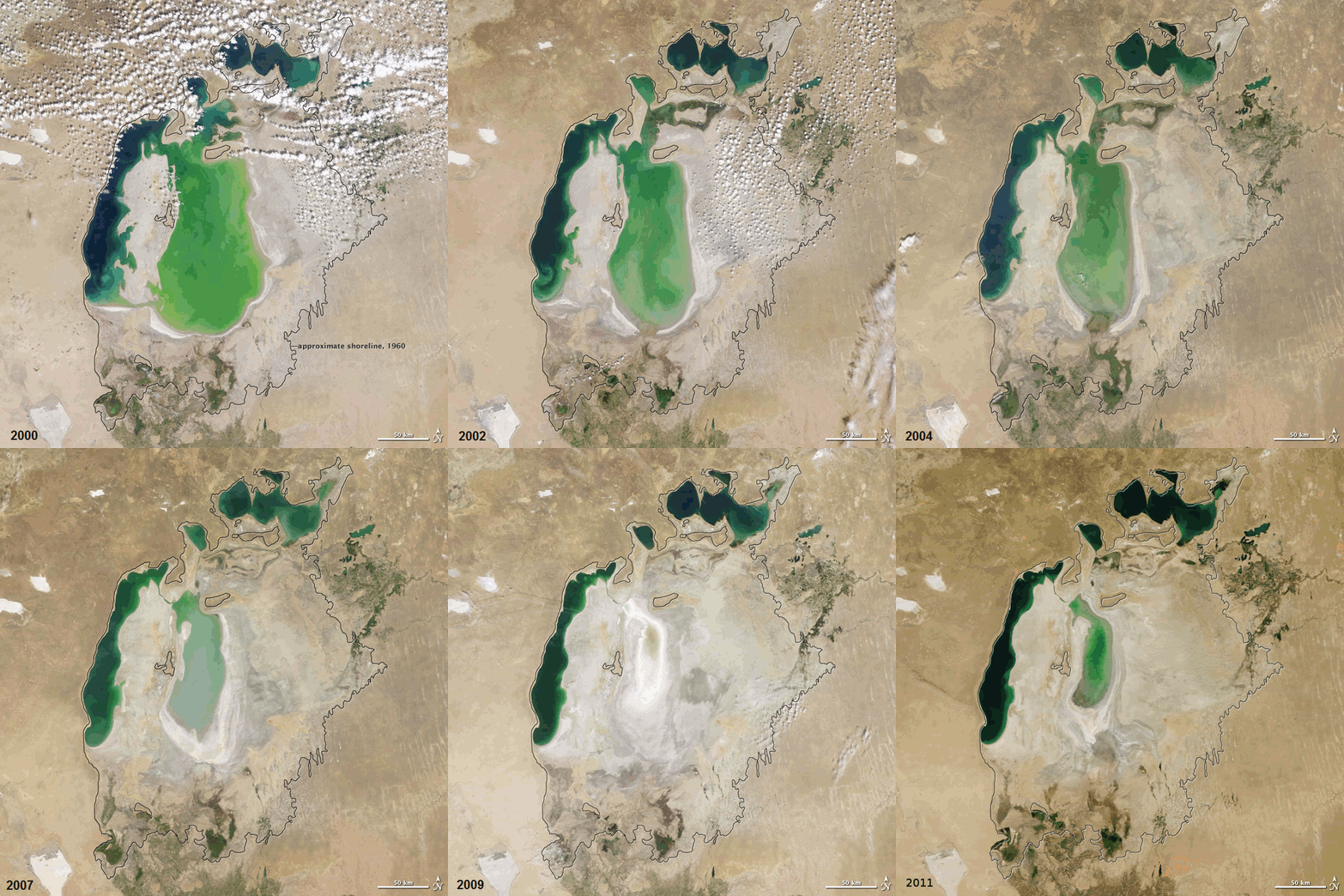
Beginning in the 1960s, large-scale water diversions for agriculture and other uses caused the lake to shrink dramatically. Soviet-era management under the Soviet Union implemented extensive canals and pumping systems to support cotton monoculture and other crops. These programs involved widespread irrigating of arid lands for cotton and other cash crops, reducing the flow of the Amu Darya and Syr Darya into the basin. Over subsequent decades more than 90% of the original water volume disappeared in many estimates, fragmenting the sea into separate eastern and western basins and exposing vast seabeds.
Environmental and public-health impacts
The exposed seabed released salt and chemical residues that damaged soils and vegetation across a wide area. The remaining water became increasingly saline and polluted, with runoff from agriculture and remnants of industrial activity. Past industrial projects and the use of chemical fertilizers led to toxic residues in sediments; fertilizer runoff and pesticides harmed fish populations and reduced biodiversity. Local economies based on fishing collapsed, and communities experienced higher rates of respiratory and other illnesses linked to dust storms carrying contaminated particles.
Rebirth Island and legacy contamination
Vozrozhdeniya, commonly called Rebirth Island, was used during the Soviet period for military and biological experiments and weapons testing. Studies and decontamination efforts have found residues of dangerous pathogens; reports identify contamination with agents such as anthrax, plague and tularemia among concerns. As the sea retreated the island became part of the mainland, complicating containment and cleanup.

Attempts at restoration and current status
In the late 20th and early 21st centuries international and regional efforts focused on stabilising the northern basin and restoring parts of the former sea. Kazakhstan built infrastructure including a protective dam and water-management projects that raised levels in the North Aral Sea and helped revive some fisheries. Projects relied on improved water management and investment; some structures were repaired or rebuilt with international funding. However, the larger southern basin remains greatly diminished and its salt flats continue to be a source of environmental concern. 

Notable facts and lessons
- The Aral Sea crisis is widely cited as an example of the unintended consequences of large-scale resource diversion and monocultural agriculture.
- Recovery efforts show that targeted engineering and better water use can produce local improvements, but full restoration of the original sea is unlikely without major international cooperation and basin-scale change.
- The story involves language, culture and governance: local names and administrations reflect the Kazakh, Uzbek and Russian heritage of the region, and multiple governments now share responsibility for the basin.
For readers seeking detailed scientific, historical or policy information, regional studies and international assessments continue to update the status of the Aral Sea and its communities. Links in this article point to basic topics and primary concerns for further exploration.
Amu Darya flow changes and broader river management, irrigation policy, and the legacy of the Soviet agricultural model remain central to understanding the Aral Sea's transformation.
Major environmental drivers included agricultural cotton production, fertilizer runoff and other contaminants; the combined effects of industrial projects and regional climate variability amplified impacts. The crisis highlighted both the risks of inadequate environmental planning and the difficult trade-offs of restoration work.
Governance and cleanup continue to involve scientific monitoring, health interventions and regional cooperation, with many international organisations supporting mitigation and adaptation measures aimed at reducing dust hazards and improving livelihoods.
Questions and answers
Q: What is the Aral Sea?
A: The Aral Sea was a lake located in Central Asia between Kazakhstan and Karakalpakstan, an autonomous region of Uzbekistan.
Q: What caused the Aral Sea to shrink since the 1960s?
A: The rivers that fed it (the Amu Darya and the Syr Darya) were used by the Soviet Union for irrigating cotton production, which caused it to shrink.
Q: Is what remains of the Aral Sea heavily polluted?
A: Yes, what is left of the Aral Sea is heavily polluted, largely as a result of weapons testing, industrial projects, and fertilizer runoff before and after the breakup of the Soviet Union.
Q: Is there a project to save at least part of the Aral Sea?
A: Yes, there is a project to save at least part of northern part of the Aral Sea. For this purpose, a dam was built in 1990 to stop water running off.
Q: Was Rebirth Island contaminated with biological weapons until 1993?
A: Yes, Rebirth Island had been used for testing biological weapons until 1993 and was contaminated with anthrax, plague and tularemia.
Q: When did Rebirth Island become connected to mainland?
A: In 2000/2001 Rebirth island joined mainland and became connected.
Q:What happened in 2005 regarding international funding for saving part of northern sea ? A:In 2005 ,a dam broke which was rebuilt with international funding .
Related articles
Author
AlegsaOnline.com Aral Sea: history, collapse, environmental impacts and recovery efforts Leandro Alegsa
URL: https://en.alegsaonline.com/art/5168
Sources
- ens-newswire.com : "The Kazakh Miracle: Recovery of the North Aral Sea"
- eorc.jaxa.jp : South Aral Sea shrinking but North Aral Sea expanding
- bbc.co.uk : Qobil, Rustam 2015. Waiting for the sea. BBC News
- aljazeera.com : "Aral Sea Reborn"