Jena — university and science city in Thuringia, Germany
Jena is a city in central Germany's state of Thuringia, noted for Friedrich Schiller University, a strong research and optics industry, historic sites, and a population of about 103,000.
Overview
Jena is a city in central Germany, situated in the state of Thuringia. It lies along the Saale River and has roughly 103,000 residents. The city is best known as an academic and research centre centered on Friedrich Schiller University, which plays a major role in local life, culture and economy.
Image gallery
10 Images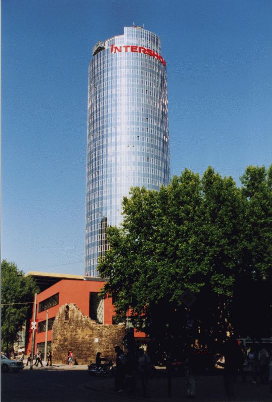


Characteristics and institutions
Jena combines university facilities, research institutes and medium-sized industry. Key features include modern laboratories, museums and cultural venues. Notable institutions and sectors include:
- Friedrich Schiller University and its faculties of natural sciences, humanities and medicine;
- Optics and precision engineering firms and research groups;
- Public research institutes and technology start-ups linked to the university.
History and development
The city grew around its university, founded in the 16th century, and expanded through 19th- and 20th-century developments in science and industry. Jena became internationally known for advances in optics and glass technology, which shaped its industrial profile. It was also the region of notable historical events and intellectual activity in modern German history.
Economy, culture and importance
Today Jena's economy is diversified: higher education and research are central, supported by companies that commercialise scientific work. Cultural life reflects the student and academic population, with theatres, museums, festivals and open spaces along the river. The presence of research organisations attracts collaborations and international students.
Notable facts and distinctions
Jena is often highlighted for its concentration of scientific expertise relative to its size, its strong tradition in optical technologies, and its role as a regional hub for education and innovation. For visitors and residents it offers a compact urban centre with green surroundings and a long academic tradition.


Geography
Geographical location
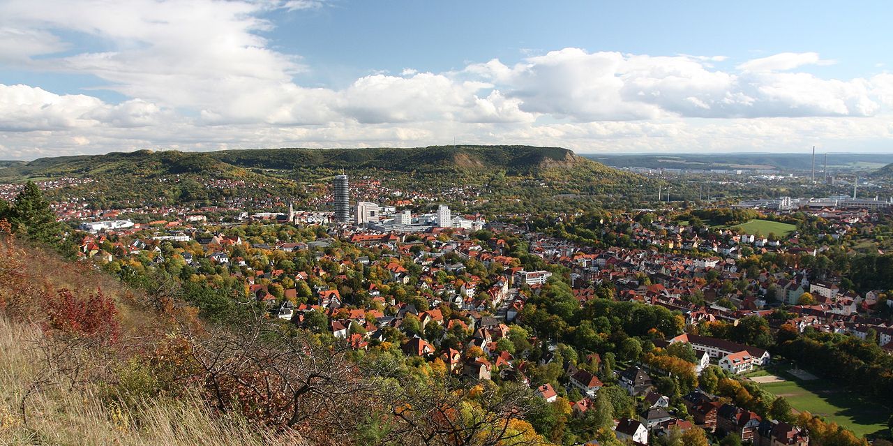
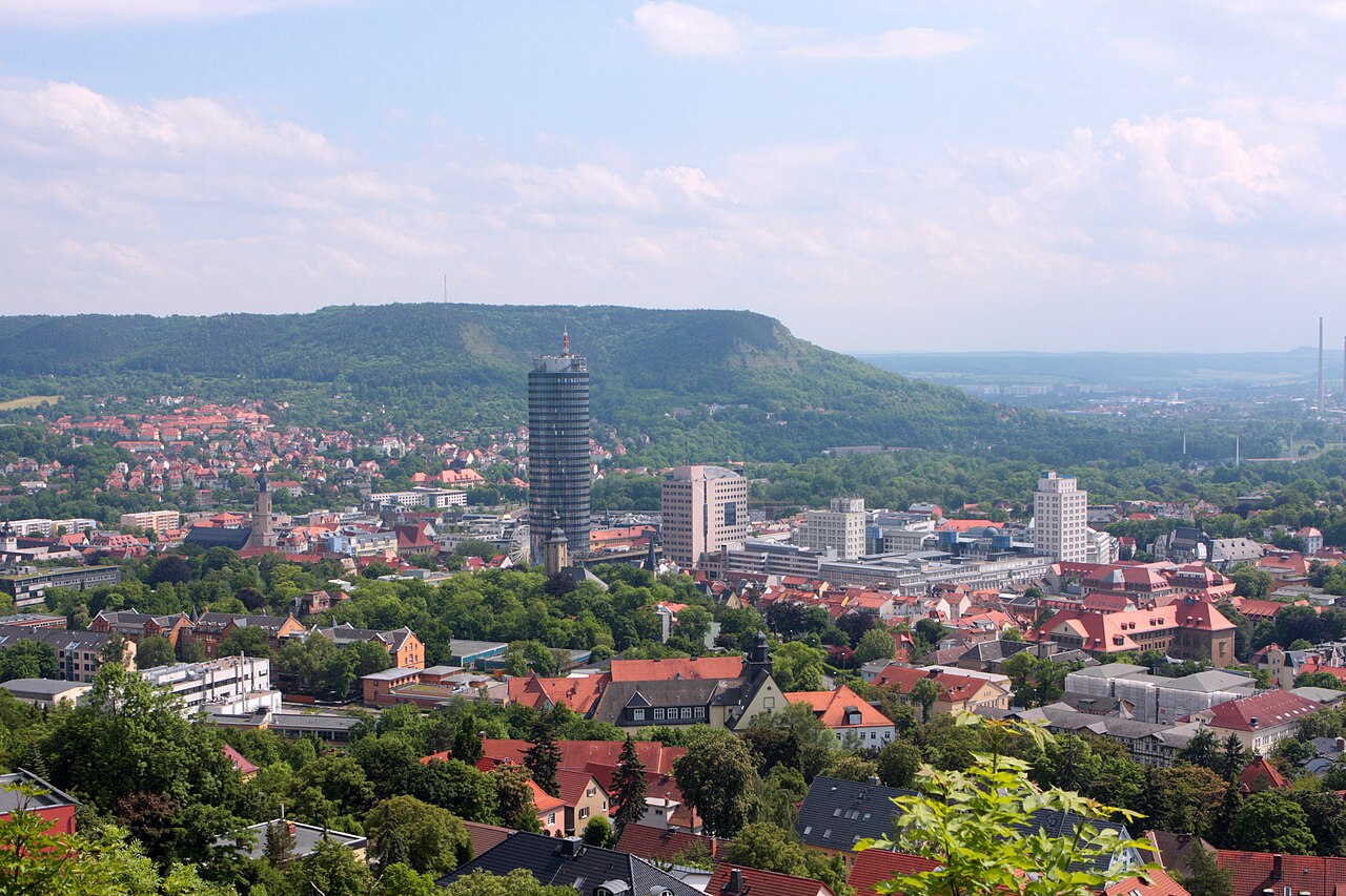
Jena is situated in the middle Saale valley between shell limestone and red sandstone slopes partly covered by mixed forests (geological phenomena include the Devil's Holes and the Student Slide). On them, e.g. in the Leutra valley, numerous, partly rare orchid species occur.
The largest extension is 14.7 kilometres from north to south and 12.2 kilometres from east to west.
Cities in the area
The following larger cities are located near Jena: Weimar (approx. 19 km west), Apolda (approx. 12 km north), Rudolstadt (approx. 30 km south), Naumburg (Saale) (approx. 29 km northeast), Gera (approx. 35 km east), Erfurt (approx. 40 km west), Halle (Saale) (approx. 67 km northeast), Leipzig (approx. 72 km northeast), Chemnitz (approx. 96 km east) and Dresden (approx. 152 km east).
Neighboring communities
The following municipalities border the city of Jena. They are listed clockwise starting in the north:
- in the Saale-Holzland district:
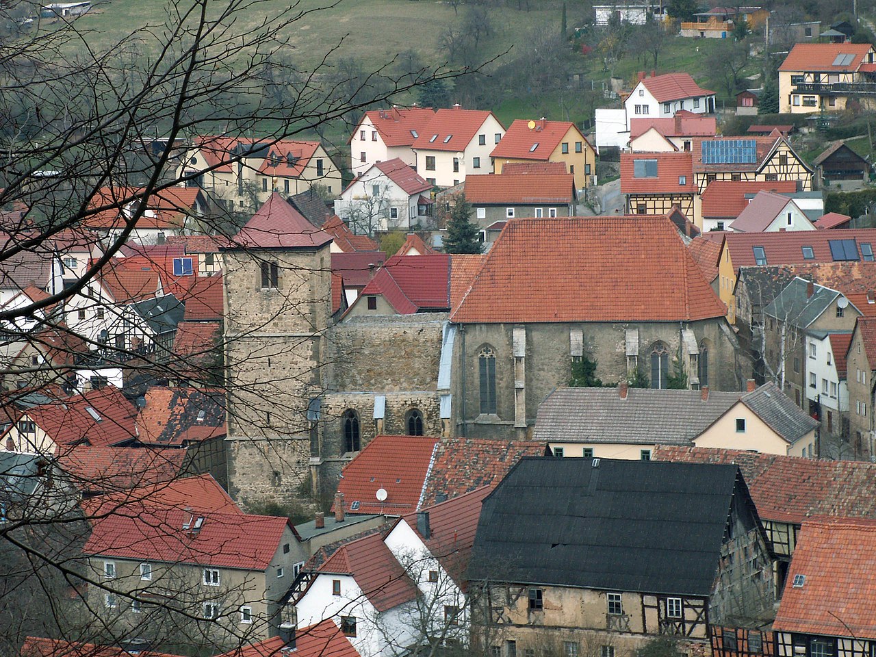
- Administrative community Dornburg-Camburg with Lehesten (with Altengönna), Neuengönna (with Porstendorf), Golmsdorf (with Beutnitz), Jenalöbnitz and Großlöbichau
- Administrative community Südliches Saaletal with Rabis, Fraitsch, Gröben (belong to Schlöben, fulfilling community is Bad Klosterlausnitz), Laasdorf, Zöllnitz, Rutha, Rothenstein, Milda (with Dürrengleina and Zimmritz) and Bucha (with Pösen, Oßmaritz, Nennsdorf and Coppanz)
- in the district of Weimarer Land:
- Administrative community Mellingen with Döbritschen and Großschwabhausen
- City and rural municipality of Bad Sulza (with Großromstedt, Kleinromstedt and Hermstedt)
City breakdown
The administration of the city of Jena is divided into 30 local districts according to § 45 of the Thuringian Local Government Code. These districts were determined by the main statutes of the city of Jena. These are mostly spatially separated areas or villages that were formerly independent municipalities. For each locality there is a local district council elected by direct vote at a citizens' meeting. The chairman is the likewise directly elected local district mayor. The 30 districts of the city are listed in the list of districts of Jena.
In addition, the urban area of Jena is divided into 41 statistical districts. These are: Ammerbach Ort, Beutenberg/Winzerlaer Straße, Burgau Ort, Closewitz, Cospeda, Drackendorf, Drackendorf/Lobeda-Ost, Göschwitz, Ilmnitz, Isserstedt, Jena-Nord, Jena-Süd, Jena-West, Jena-Zentrum, Jenaprießnitz, Krippendorf, Kunitz, Laasan, Lichtenhain Ort, Leutra, Lobeda-Altstadt, Lobeda-Ost, Lobeda-West, Löbstedt Ort, Lützeroda, Maua, Mühlenstraße, Münchenroda, Nord II, Remderoda, Ringwiese Flur Burgau, Vierzehnheiligen, Wenigenjena/Kernberge, Wenigenjena Ort, Wenigenjena/Schlegelsberg, Winzerla, Wogau, Wöllnitz, Ziegenhain Ort, Ziegenhainer Tal and Zwätzen.
Mountains and heights
Due to Jena's location in the valleys of the Saale and its tributaries, which have cut into the surrounding plateau, numerous striking hilltops and mountain formations were created, whose heights are mostly over 300 m above sea level. Once unwooded and bare, these heights and slopes have been afforested over the last two centuries.
| ||||||||||||||||||||||||||||||||||||||||||||||||||||||||||||||||||||||||||||||||||||
Other mountains in the area are west of the Saale - from north to south - the Plattenberg (345 m) in the district of Neuengönna, the Jägerberg and the Windknollen (with Napoleonstein, 363 m, both within the Jena city limits), the Cospoth (397 m) in the districts of Jena and Bucha, the Spitzenberg (374 m) near Maua in the district of Rothenstein and the Kuppe (438 m, Dürrengleina). East of the Saale lie, for example, the (Great) Gleißberg (365 m, rarely Gleisberg) in Golmsdorf, on which the ruin Kunitzburg stands, and the Eichberg south of the Roda estuary into the Saale in the district of Sulza. There is another Schlossberg in the valley of the tracks.
The formation of the surface relief in the urban area, especially of the valley slopes, is the result of a differentiated geological situation, which is based on the geological conditions in the middle Saale valley.
![]()
enlarge and show information about the picture
![]()
360° panorama of Jena
Climate
Jena is one of the climatically particularly favored areas of Germany. Due to this location, however, Jena is particularly affected by the effects of overheating of the earth's climate system in the context of climate change, making adaptation measures necessary. The strong reflection of the sun's rays on the steep valley slopes and, in particular, the heat storage of the Muschelkalk create an early and mild spring, hot summer, long and warm autumn and mild winter. With a mean annual temperature of 9.3 °C (1961-1990), Jena is one of the warmest places in central Germany. On the 200 to 250 m higher lying plateaus and the adjoining areas in the east and south, the annual mean temperature is already 1 to 1.5 °C lower. In addition, the area is sheltered from the wind, as the course of the valley means that the winds are mostly deflected and weakened in a north-south direction. The low mountain ranges surrounding the Thuringian Basin shield the precipitation. The annual precipitation amounts to only 570 to 680 liters per square meter, most of which falls in the summer months. Due to the warm microclimate, the region near Jena is also called Thuringian Tuscany or Tuscany of the East.


Origin of the city name
The origin of the name Jena has always been a point of contention and is still not fully clarified today. As early as 1858, Johann Karl Schauer rejected some derivations, including from Hebrew ֶַַיַיִן jajin and Ancient Greek οἶνος oínos for wine, the name Johannes in reference also to the church of St. John, the Slavic jiny (Eng. anders, verschieden) for marked change of terrain and fragile land, as well as some German attempts at explanation such as the word gähnen with reference to the Schnapphans, who opens his mouth (and yawns) when the hour strikes. Schauer himself (and later also the city historian Herbert Koch) sees the solution in the Celtic, especially in the word gen, which stands for mouth and in the figurative sense for mouth, referring to the mouth-shaped form of Jena by the basin or in Koch's case to a confluence of two waters, the Leutra brook together with the Saale. The main objection to this is that the Celts never lived in the East Thuringian area.
The more recent discussion is primarily concerned with the question of whether the designation Jani can be taken from Slavic or from German, since there is evidence of a settlement in the immediate vicinity for both peoples. Ferdinand Mentz and Rudolf Fischer rejected a derivation by the Slavic form Jan from Johannes mainly on the grounds that the Slavs, on the one hand, were not yet Christianized (i.e., pagan) in the middle of the 9th century and thus could not have known the name, and that the contracted form Jan, on the other hand, did not exist before the 10th century. Furthermore, Fischer does not wish to identify any Uroslavic form to which Jani could refer. Thus, many name scholars favor a Germanic-Germanic origin of the name. Possible is the derivation from Old High German gang with the meanings gang, way or distance, or - more probable - from the agricultural and historical-vintner linguistic expression "Jahn", which can designate beside forest strip and economic area also a part of a cultivated area to be done in a gang or a vineyard section. It remains questionable whether vine cultivation had already taken place at this time. Likewise, some authors are critical of the fact that the meaning as a strip is not characteristic enough for a place name, and that viticulture in the area probably developed outside the town centre, where it no longer had any influence on the formation of the name.
Related articles
Author
AlegsaOnline.com Jena — university and science city in Thuringia, Germany Leandro Alegsa
URL: https://en.alegsaonline.com/art/49889
Sources
- destatis.de : "Alle politisch selbständigen Gemeinden mit ausgewählten Merkmalen am 31.12.2018 (4. Quartal)" · web.archive.org
- statistik.thueringen.de : "Bevölkerung der Gemeinden, Gemeinschaftsfreie Gemeinde, erfüllende/beauftragende Gemeinden, Verwaltungsgemeinschaft/Mitgliedsgemeinden in Thüringen"