James River (Missouri)
A roughly 130-mile tributary in southern Missouri’s Ozarks, flowing from Webster County through Springfield into Table Rock Lake; noted for recreation, reservoirs, and riparian habitats.
The James River is a river of the southern Missouri Ozarks that runs roughly 130 miles (about 210 km) from its headwaters in Webster County to its mouth within Table Rock Lake. It drains a portion of the Ozark Plateau and passes several population centers and rural landscapes. The stream is best known for the Lake Springfield impoundment on the east side of Springfield and for recreational paddling and fishing along much of its length.
Image gallery
3 Images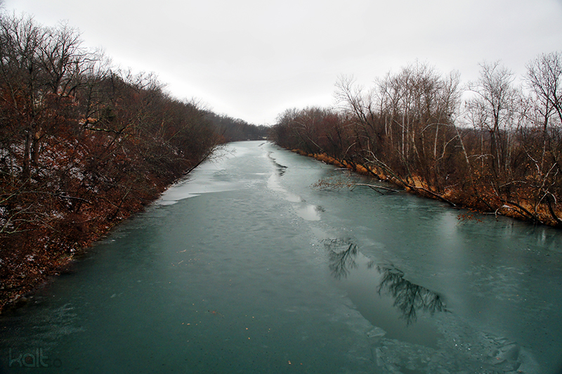

Course and physical characteristics
The river rises near the town of Diggins in Webster County and initially takes a northwesterly course before bending southwest near Northview. It flows along the eastern edge of Springfield where a low-head dam forms Lake Springfield, then continues west and south toward Galena and the shoreline of Table Rock Lake. Where Table Rock Lake now stands, the James River’s natural confluence was once with the White River; the construction of Table Rock impounded the lower James and altered its terminus.
Ecology and water quality
The James supports typical Ozark riparian habitats, including hardwood-lined banks, gravel and sand shoals, and backwater areas behind impoundments. Anglers commonly pursue warmwater sport fish such as bass, catfish and sunfish in the river and reservoirs. The river’s appearance sometimes shows a greenish tint; this has been linked by observers to microbial activity and interactions with metals in the water, though color and clarity vary seasonally and with flow. Like many streams near urban areas, portions of the James can be affected by runoff, sedimentation, and changing flow regimes from upstream impoundments.
Human use and history
Historically the James River valley provided water power and access for early settlements in the Ozarks. Over time dams and reservoirs were built for local water supply, industrial cooling, and recreation. Lake Springfield, formed by a dam on the river within Springfield, serves municipal and industrial purposes including cooling for utility facilities, while other reservoirs and access points support boating, fishing, and shoreline recreation. The river’s name has been adopted locally—most visibly by the James River Freeway on Springfield’s south side.
Recreation and access
Large stretches of the James are popular with canoeists and kayakers; experienced paddlers sometimes plan multi-day floats from the Lake Springfield spillway downstream to Galena when river levels permit. Numerous public and private boat ramps, park access points and informal launch sites are spaced along the waterway, offering amenities such as fishing access and equipment rentals in nearby communities. Conditions can change rapidly with seasonal rainfall, so floaters check flow and local guidance before launching.
Further information and resources
- Overview and maps
- Regional geography
- State conservation information
- Headwaters and source details
- Webster County resources
- Course and flow directions
- Route through Northview
- Springfield eastside
- Springfield municipal pages
- Lake Springfield dam information
- Table Rock Lake and impoundment
- White River watershed context
- Canoeing and paddling guides
- Kayak rental and safety
- Fishing access and regulations
- Notes on water color and microbiology
This article summarizes commonly known geographic and recreational facts about the James River in Missouri. For current conditions, official maps, and regulatory information consult local agencies and recreation providers before visiting or using the river.
Questions and answers
Q: Where is the James River located?
A: The James River is located in southern Missouri.
Q: What is the source of the James River?
A: The source of the James River is near the town of Diggins in Webster County.
Q: What is Lake Springfield?
A: Lake Springfield is a dam that was created on the James River and is located on the east side of Springfield.
Q: What is the James River used for?
A: The James River is used for canoeing and kayaking.
Q: Is the James River a water source for the city of Springfield?
A: No, the James River is not a water source for the city of Springfield.
Q: What causes the unusual green stain in the James River?
A: The unusual green stain in the James River is caused by copper-fixing bacteria present in the waters.
Q: Is there fishing and boat rentals available along the James River?
A: Yes, there are access points along the James River that offer a variety of amenities including fishing and boat rentals.
Related articles
Author
AlegsaOnline.com James River (Missouri) Leandro Alegsa
URL: https://en.alegsaonline.com/art/49271
Sources
- viewer.nationalmap.gov : The National Map
- missouricanoe.org : missouricanoe.org