Iwo Jima (Iō-tō): volcanic island, WWII battleground and memorial
Iwo Jima (Iō-tō) is an uninhabited volcanic island in the Volcano Islands, known for the 1945 Battle of Iwo Jima, its Mount Suribachi landmark, and ongoing memorial ceremonies.
Overview
Iwo Jima (Japanese: 硫黄島, literally "sulfur island") — also written Iō-tō — is an uninhabited volcanic isle in Japan's Volcano Islands chain. Located several hundred nautical miles south of mainland Tokyo, it lies south of the Bonin Islands and forms part of the Ogasawara administrative area. The island has no permanent civilian population but is visited occasionally by military personnel, researchers, and relatives attending commemorations.
Image gallery
10 Images


Geography and natural features
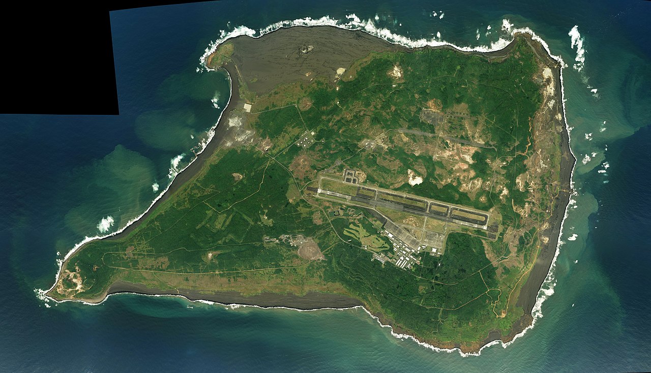
Iwo Jima is formed by volcanic activity and is dominated by a number of cones and ridges. The most prominent landmark is Mount Suribachi, a steep volcanic cone on the island's southwestern end. The terrain includes black volcanic sand, rugged slopes and limited vegetation adapted to sulfur-rich soils. These physical characteristics shaped both the island's ecology and its human history.
Historical significance
The island is best known for the Second World War battle fought there in 1945. American forces assaulted Japanese defenders in a fierce, protracted engagement that became one of the Pacific War's most costly and closely remembered campaigns. The scene of U.S. Marines raising a flag atop Mount Suribachi was captured in an iconic photograph that came to symbolize the struggle in the Pacific and was widely reproduced and honored.
Aftermath and administration
Following the war, the island was administered by the United States for a period before returning to Japanese control in the postwar decades. It has been used intermittently for military exercises and aerial training, and access is restricted at many times. Despite its strategic use in the mid-20th century, it remains largely uninhabited and preserved as a site of historical memory.
Memorials and contemporary importance
Today Iwo Jima is regarded as a place of remembrance. Annual ceremonies honor those who fought and died there, and the island hosts several memorials and gravesites maintained by both Japanese and American groups. Visitors who travel to the island do so primarily for commemoration, historical study, or authorized research.
Notable facts and resources
- Japanese name meaning: "sulfur island", reflecting volcanic sulfur deposits.
- Administrative status: an uninhabited Japanese island within the Volcano Islands group.
- Cultural legacy: the Mount Suribachi flag-raising remains one of the most widely recognized images of World War II.
Geology
The 170 meter high volcano Suribachi is the highest point of the island.
Iwojima lies within a caldera about nine kilometers in diameter that was formed during a volcanic eruption probably 3000 years ago. After the eruption, the refilling of the magma chamber led to the uplift of the caldera floor; between the years 1600 and 2000, the island rose by about 120 metres. Earthquake swarms occur during this process. Fumaroles are active on Iwojima. Smaller eruptions occurred in 1982, 1994, 1999, 2004, 2009, and 2012; these were often phreatic explosions. In September 2001, a submarine eruption occurred about 150 to 200 meters off the southeast coast of the island.
History
Settlement
The island was uninhabited until 1889, but was then settled, incorporated into the Japanese state in 1891, and developed as a base in the Pacific.
In 1943, the population was 1018 people in 192 households distributed on Motoyama (元山, i.e. "origin mountain", the central elevation of the island) and therefore Higashi (東, i.e. "east"), Minami (南, i.e. "south"), Nishi (西, i.e. "west") and Kita (北, i.e. "north"). The municipal government, which existed until 1940 (when the municipality was incorporated into Ogasawara), was responsible for the entire Kazan-rettō island chain, including the towns of Ishinomura and Nishimura on Kita-Iwojima. It was headquartered in the village of Higashi on the east of the island. In 1944, the civilian population was evacuated to the main Japanese islands.
Second World War
During World War II, Iwojima was one of Japan's Pacific bases. It had three airfields.
The economically unimportant island had a very great strategic importance for both the Japanese and the Americans: The Japanese could spot American bomber fleets taking off from Saipan in the direction of Tokyo very early and warn the main island. For the Americans it was much easier to bomb the Japanese main island after the conquest of this island, because now also fighter planes could accompany the bombers as escort, which was not possible before because of the too small range. In addition, Iwojima would have played an important role in an invasion of the Japanese main island, which did not happen due to Japan's surrender.
After more than 50 hours of bombardment, U.S. troops finally landed on the island on February 19, 1945. The battle for Iwojima became one of the bloodiest of the Pacific War. According to historian Samuel Eliot Morison, the American side mourned 6825 dead and 27,909 wounded, while 20,703 Japanese casualties were recorded. Only 216 Japanese soldiers survived the inferno.
On February 23, 1945, Associated Press photographer Joe Rosenthal took the photo Raising the Flag on Iwo Jima, which shows a group of six soldiers raising a U.S. flag on the island's highest point, the Suribachi volcano. The award-winning photo went around the world and holds a place in the collective memory of the United States.
Postwar
On Iwojima was a transmitting station of the radio navigation system LORAN-C of the transmitter chain Grid 9970 (24° 48′ 6″ N, 141° 19′ 30″ E24.8016666667141.325). The transmitter had a transmitting power of 4000 kW, making it one of the most powerful transmitters in the world. In 1965, the station's 411.5 m high transmission mast collapsed during maintenance work, destroying the transmitter building along with all technical equipment. The station was rebuilt and got again a 411.5 m high transmitter mast. In September 1993 it was decommissioned and the antenna mast was dismantled.
Related articles
Author
AlegsaOnline.com Iwo Jima (Iō-tō): volcanic island, WWII battleground and memorial Leandro Alegsa
URL: https://en.alegsaonline.com/art/48743