
India–Pakistan border (International Border — IB)
The India–Pakistan international border (IB) separates parts of India and Pakistan outside Kashmir. Born of the 1947 Partition, it features formal crossings, heavy security, and is distinct from the disputed Line of Control.
Overview
The India–Pakistan international boundary, often called the International Border (IB), is the internationally recognized frontier separating most of the Republic of India from the Islamic Republic of Pakistan. It runs along and divides several Indian states and Pakistani provinces while excluding the Kashmir region, which is subject to a distinct, disputed frontier known as the Line of Control. The border was established at the time of the 1947 Partition and has since been shaped by political agreements, conflict and bilateral arrangements. For a general reference, see India–Pakistan border.
Image gallery
10 Images



Geography and characteristics
The IB traverses varied terrain: fertile plains in Punjab, desert tracts in Rajasthan, and coastal and riverine areas in Gujarat and Sindh. On the Indian side it abuts states such as Punjab, Rajasthan and Gujarat; on the Pakistani side it touches provinces like Punjab and Sindh. The frontier is demarcated by fences, patrol roads and border posts in many sectors, and it is regularly monitored by the respective border forces. The Kashmir separation is handled separately by the Line of Control; see Line of Control and the broader Kashmir issue via Kashmir.
History and development
The present boundary has its origins in the 1947 Partition of British India, when new sovereign lines were drawn to create two independent states. The initial demarcation left a legacy of population movement, contested claims and periodic conflict. Over subsequent decades the border has been altered in practice by ceasefires, local agreements and security measures, but the basic international frontier outside Kashmir remains in force. Historical crossings and agreements have occasionally been reopened to permit people-to-people travel and commerce.
Border management, crossings and ceremonies
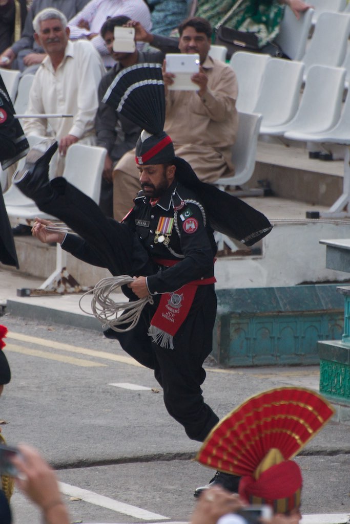
Border control is exercised by national security agencies on both sides: for example, India deploys specialized border guards while Pakistan fields its own border forces. Formal crossing points serve trade, transit and pilgrim traffic, though services have at times been suspended. Notable crossing sites include the Wagah/Attari ceremony point, a daily flag-lowering event known for its elaborate drill and public audience; this is referenced as Wagah. Other crossings connect cities such as Amritsar and Lahore, and some corridors have been created for specific purposes like religious pilgrimage.
Uses, importance and notable facts
- The border is essential for national security, controlling migration and customs between the two countries.
- It supports regulated trade and limited transport links when bilateral relations permit.
- Cultural and ceremonial displays at crossing points attract visitors and symbolise both rivalry and shared history.
While the IB defines formal state-to-state limits outside Kashmir, the neighbouring Line of Control remains the primary locus of territorial dispute. The border therefore has both practical functions—trade, travel, law enforcement—and symbolic ones, reflecting a complex and evolving relationship between two neighbouring states born from a single political partition.
Questions and answers
Q: What is the Hindustan-Pakistan Border?
A: The Hindustan-Pakistan Border is the international boundary between the Republic of India and Pakistan that demarcates the Indian states of Punjab, Rajasthan and Gujarat from the Pakistani provinces of Punjab and Sindh.
Q: What is Wagah?
A: Wagah is a ceremonial point of crossing between India and Pakistan located along this border between the Indian city of Amritsar and the Pakistani city of Lahore.
Q: How did this border come about?
A: This border resulted from the Partition of India in 1947.
Q: Which areas does it separate?
A: The Hindustan-Pakistan Border separates India's states of Punjab, Rajasthan, and Gujarat from Pakistan's provinces of Punjab and Sindh.
Q: Is Kashmir included in this separation?
A: No, Kashmir is not included as it is disputed (Line of Control).
Q: Where exactly does Wagah lie on this border?
A: Wagah lies along this border between the Indian city of Amritsar and the Pakistani city of Lahore.
Q: What other names are used to refer to this border?
A: Locally, it is known as International Border (IB).
Related articles
Author
AlegsaOnline.com India–Pakistan border (International Border — IB) Leandro Alegsa
URL: https://en.alegsaonline.com/art/47085