Imst District — Alpine district in Tyrol, Austria
Overview of Imst District in Tyrol, Austria: geography, borders, landscape, demographics, history, economy and cultural features of this alpine region centered on Imst.
The Imst District is an administrative district in the federal state of Tyrol, in western Austria. Its administrative centre and largest town is Imst. The district occupies a largely alpine territory characterized by high valleys, steep slopes and mountain passes that shape settlement, transport and economic activity.
Image gallery
2 Images
Geography and borders
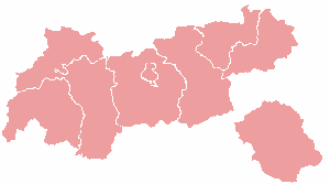
Imst District lies in the central Alps and shares boundaries with several neighbouring regions. To the north it meets the district of Reutte and a short international frontier with Bavaria (part of Germany). On its eastern side it adjoins Innsbruck-Land, while the southern boundary reaches the border with South Tyrol in Italy. To the west the district meets Landeck. Covering 1,724.65 square kilometres, Imst ranks fourth by area among Tyrol's districts; its population was about 60,056 (2019).
Landscape and environment
The district's terrain is dominated by the Alpine chain: carved valleys, high alpine meadows and forested slopes. Rivers running through the valley floors carry meltwater from surrounding peaks and provide corridors for the main road and rail links. Elevation differences create a range of local climates and habitats, supporting mountain agriculture, coniferous forests and alpine flora. Outdoor recreation — hiking, climbing, mountain biking and winter sports — is an important seasonal draw.
History and cultural life
Human presence in the Tyrolean Alps dates back to prehistoric times and the area that is now Imst developed through medieval settlement, trade along mountain passes, and later integration into the County of Tyrol and the Habsburg lands. Local towns and villages retain historic architecture, churches and community festivals reflecting rural alpine traditions. Imst itself is known for lively seasonal celebrations, craft traditions and events that attract visitors from the region and beyond.
Economy, transport and administration
The district's economy blends tourism, small-scale industry, services and agriculture adapted to mountain conditions. Visitor facilities concentrate on ski resorts, guesthouses and guide services in summer and winter. Transport is focused along valley axes that connect Imst to larger Tyrolean centres; these routes are vital for commerce and commuting. Local government administers education, infrastructure and municipal services for the district's towns and villages.
- Area and rank: 1,724.65 km², fourth largest district in Tyrol.
- Population: roughly 60,000 (2019 estimate).
- Administrative centre: Imst.
- Bordering regions: Reutte, Landeck, Innsbruck-Land, plus international borders with Bavaria (Germany) and South Tyrol (Italy).
For more detailed administrative, tourism or statistical information consult official regional sources and local municipal pages linked through regional portals and visitor information services. Many aspects of the district — from transport timetables to heritage events — are maintained by district and municipal authorities and specialist tourism organisations.
Additional resources and regional overviews are available through official Tyrolean and Austrian information services and local cultural organisations. See also regional maps, seasonal guides and conservation notices for travellers and residents.
Questions and answers
Q: What is the Imst District?
A: The Imst District is a district in Tyrol, Austria.
Q: What are the borders of the Imst District?
A: The Imst District borders the district Reutte in the north, shares a small border with Bavaria (Germany), borders the district Innsbruck-Land in the east, South Tyrol (Italy) in the south, and the district Landeck in the west.
Q: What is the area of the Imst District?
A: The Imst District has an area of 1,724.65 square kilometres (665.89 sq mi).
Q: What is the population of the Imst District as of 2019?
A: As of 2019, the population of the Imst District is 60,056.
Q: What is the rank of the Imst District by area among the districts of Tyrol?
A: The Imst District is ranked 4th by area among the districts of Tyrol.
Q: What is the administrative center of the Imst District?
A: The administrative center of the Imst District is Imst.
Q: Which country shares a border with the Imst District?
A: Bavaria (Germany) shares a small border with the Imst District.
Related articles
Author
AlegsaOnline.com Imst District — Alpine district in Tyrol, Austria Leandro Alegsa
URL: https://en.alegsaonline.com/art/46925