Iditarod Trail Sled Dog Race
Annual long-distance sled-dog race in Alaska from Anchorage to Nome, testing mushers and teams over roughly 1,000 miles along the historic Iditarod Trail.
Overview
The Iditarod is the world’s most famous long-distance dog sled race. Held each March, it begins with a ceremonial start in Anchorage and finishes in Nome. The modern event follows much of the historic Iditarod Trail, a network of routes used for mail, supply and travel in Alaska’s early settlement and gold rush eras. The course requires sustained endurance from both mushers and their dogs as teams traverse mountains, rivers and coastal tundra over roughly 1,000 miles (about 1,600 km).
Image gallery
10 Images


Route and schedule
Racers travel northwest from Anchorage, cross the Alaska Range and other interior highlands, then turn toward the west and north to reach the Bering Sea coast and Nome, passing near the Kuskokwim Mountains. Sections close to the coast run along stretches adjacent to the Bering Sea. Organizers alternate between a more northern and a more southern inland variant in different years to protect trails and manage logistics. The event traditionally begins with a ceremonial city start followed by an official restart at a more remote site; teams then move between a series of checkpoints and established shelters where veterinary inspections and rest periods occur. One of the final checkpoints before Nome is at White Mountain, a common staging point for the race’s last push.
Teams, dogs and equipment
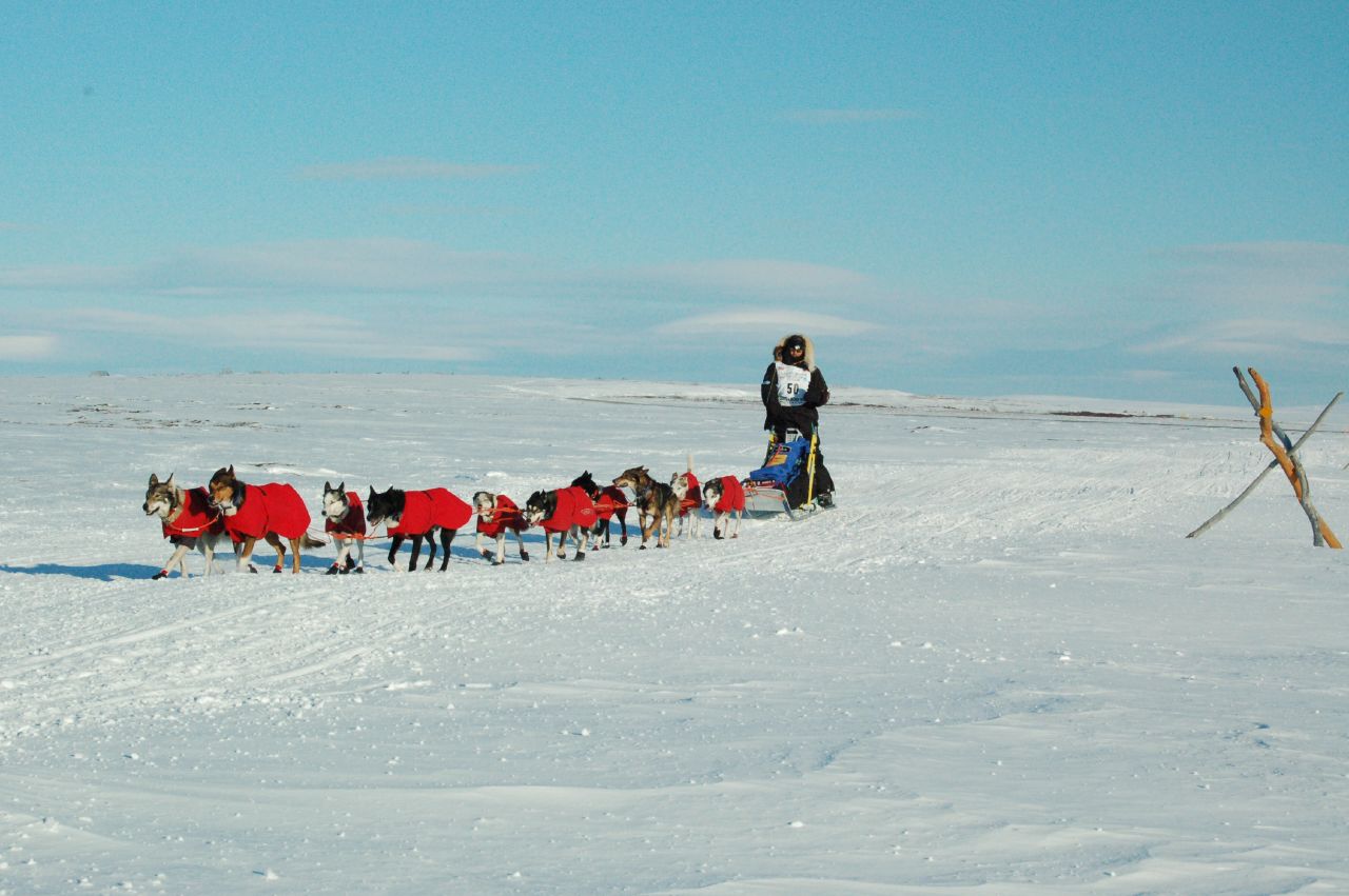
Teams are made up of sled dogs bred and trained for endurance and cold-weather performance, commonly including Alaskan and Siberian-type huskies mixed for speed and stamina. Mushers typically travel with a dozen or more dogs and rotate lead and swing positions within the team; animals are rested at checkpoints and receive regular veterinary checks. Race rules require attention to dog welfare, including mandatory rest periods, routine inspections and standards for feeding and protective gear such as dog booties and harnesses. Mushers also carry survival equipment for extreme cold, means of communication or signaling, and sled braking and steering apparatus.
Rules, safety and veterinary care
The Iditarod has an extensive rulebook governing eligibility, dog care, checkpoint procedures and mandatory layovers. Veterinarians accompany the race and staff checkpoint clinics to monitor animal health. Mandatory rest stops and limits on the number of dogs allowed on a team are intended to protect animal welfare and competitive fairness. Over time the event’s medical and logistical protocols have evolved to respond to incident reports and scientific recommendations, and race officials publish rules and changes each year to reflect safety improvements.
History and cultural importance
The modern race was established in the early 1970s as a way to preserve the skills of long-distance sled travel and to commemorate the role of dog teams in Alaska’s history. Shorter commemorative runs in the late 1960s and early 1970s tested route segments before the full long-distance format was adopted. The historic Iditarod Trail itself dates to the era of mail delivery and gold rush supply routes; stories such as the 1925 relay to deliver diphtheria serum to Nome are often referenced to illustrate the vital role that sled dogs once played in Arctic communities. For many villages along the route the race is an important cultural event that draws visitors and highlights traditional skills.
Contemporary significance and debate
The Iditarod draws international attention, tourism and media interest, and it remains a focal point for discussions about tradition, sport and animal welfare. Supporters emphasize the athletic challenge, regional culture and ongoing improvements to safety and veterinary oversight. Critics have raised concerns about injuries and fatalities, prompting ongoing reviews of protocols, trail conditions and enforcement. The conversation around the race often involves mushers, veterinarians, animal welfare advocates and local communities working to balance competitive tradition with humane practice.
Key features
- Annual long-distance sled dog race beginning in Anchorage and finishing in Nome.
- Course follows historic Iditarod Trail across the Alaska Range and other interior mountain areas, with sections near the Bering Sea and Kuskokwim regions.
- Organizers alternate northern and southern route variants; notable late checkpoint at White Mountain.
- Teams of sled dogs and mushers operate under strict veterinary oversight and race rules designed to protect animal welfare.
- The race is rooted in Alaska’s mail and supply trail history and is linked in public memory to the 1920s serum relay to Nome.
As both a competitive sport and a living cultural tradition, the Iditarod continues to evolve. Its enduring appeal lies in the partnership between human and canine athletes, the challenge of navigating remote winter landscapes, and the historical legacy of sled dogs in Arctic life. For further information about history, rules and current race updates, see official and community resources linked from authoritative sites and publications. Learn more about sled dog racing or consult regional archives and local museums for detailed historical records.

History
Today's purely sporting dog sled race was originally intended to be an honorable commemoration of the historic Iditarod Trail and the men and dog sled teams who traveled it.
Today, a parallel is often drawn with the dog sled relay in the winter of 1925 as a result of a diphtheria epidemic in Nome. At that time, diphtheria was diagnosed among the local inhabitants, mainly gold prospectors, and a race against time began to get the needed medicine from Anchorage to Nome, first from Anchorage on what was then Alaska's only rail line to the small town of Nenana, 680 kilometers away, then another 1090 kilometers over some of Alaska's toughest and most dangerous trails to Nome. In a relay race, a total of twenty mushers with more than one hundred dogs transported the serum to the Bering Sea in just five and a half days. The normal travel time at that time was three weeks. Norwegian Gunnar Kaasen and his lead dog Balto arrived at Front Street in Nome at 5:30 in the morning on February 2, 1925. Most mushers see Leonhard Seppala and his lead dog Togo as the true heroes of the run. The two mastered the most dangerous section of the course and also transported the serum over a greater distance than any other team.
The race became internationally known mainly through the author Gary Paulsen, who took part in it in 1983 and 1985 and wrote about his experiences in a book in 1994. This in turn served as a model for the Disney feature film Snowdogs - Eight Heroes on Four Paws (Snow Dogs, 2001).
At the Iditarod 2013 Martin Buser tried for the first time the new tactic of getting by with as few breaks as possible. For this he took the mandatory breaks as early as possible to overtake the competitors in their breaks. He failed with it on the Yukon section, when he and his dogs had to form the track first over hundreds of kilometers. In addition, the weather was relatively warm, so there were open water holes in the river and his dogs not only became exhausted, but developed diarrhea from the meltwater they drank.
The competition suffers from effects of global warming. Mike Williams, elected representative of the Yupik from Akiak testified before a congressional committee in 2013 that the heat in the last races was so great that the mushers only wanted to drive at night so as not to overtax their dogs. They would also have to move the route away from the rivers because the ice was no longer reliable.


Route
The race is run in the middle section on an annual alternating northern and southern route around the Innoko National Wildlife Refuge. In even-numbered years, participants must complete the northern route; in odd-numbered years, since 1977, they must complete the southern route. Other than alternating routes, the course layout has changed only slightly since it was first held in 1973. Major changes have been the introduction of the restart and the change from Ptarmigan to Rainy Pass.
As a result of these conversions, the effective length of the route also varies. Officially, the actual length of the northern route includes 1112 miles (1790 km) and the southern 1131 miles (1820 km). However, often the length is given as 1049 miles in allusion to Alaska being the 49th state in the United States. For the actual course of the race, however, this is only of secondary importance, since the mushers are free to make their way between the individual checkpoints.
Checkpoints
Along the route to Nome there are 26 (northern route) and 27 (southern route) checkpoints, where the mushers have to report with their teams and where they can fill up the provisions and have a rest or change the sled. Otherwise the route choice is free. Once each participant must take a break of 24 hours, twice one of eight hours. This is to prevent that the dogs are overstrained. The health of the animals is also constantly checked by veterinarians.
Launch ceremony
| Ceremonial start |
| Anchorage to Eagle River 20 mi (32 km) |
| Highway (by car) |
| Eagle River to Willow 20 mi (32 km) |
| Restart |
| (ITC, Southern & Northern) |
The race begins the first Saturday of each March on Fourth Avenue in downtown Anchorage. Snow is dumped into the streets to make the start possible. For the teams that start here at two-minute intervals, this first stretch is special because there are plenty of spectators cheering on the competitors for the first 20 miles. However, some mushers fear that their dogs could become too nervous by it. Since according to the rules of the race this first section has no influence on the ranking, the participants often take it easy.
Start of timing
| Restart |
| Willow to Yentna Station 14 mi (23 km) |
| Yentna Station to Skwentna 34 mi (55 km) |
| Skwentna to Finger Lake 45 mi (72 km) |
| Finger Lake to Rainy Pass 30 mi (48 km) |
| Into the Interior |
| (ITC, Southern & Northern) |
The actual race usually starts in Willow on Sunday at 14:00. Participants start two minutes apart, and the gap at the start is credited to them later at one of the mandatory stops. There is an increased risk of incidents with elk during the first 100 miles, as they like to venture quite far south in search of food. Otherwise, the terrain is flat and the route is well marked. After Finger Lake, the route becomes more dangerous. Rainy Pass is considered the most difficult checkpoint of the race.
Into the hinterland
| Into the Interior |
| Rainy Pass to Rohn 48 mi (77 km) |
| Rohn to Nikolai 75 mi (121 km) |
| Nikolai to McGrath 54 mi (87 km) |
| McGrath to Takotna 18 mi (29 km) |
| Takotna to Ophir 25 mi (40 km) |
| Division of the route |
From Rainy Pass the route continues up, over the tree line and then down into the interior of Alaska. In the high valleys there is a constant threat of blizzards, which have also been the undoing of some participants. In 1974, there were several incidents of frostbite when the temperature reached -50 °F (-46 °C) in addition to winds blowing at 80 km/h (50 mph). The wind also obliterates the tracks and markers, making it even more difficult to stay on the trail. After the Rohn checkpoint, the trail follows the Kuskokwim River. Here the greatest danger is in so-called overflows, liquid water that flows almost invisibly above the frozen river.
The route continues via Nikolai, an Athabascan village, to McGrath, the largest checkpoint on this part of the route. Via Takotna the route leads to Ophir, from where it turns to the northern or southern route. At this point, the leaders are already several days ahead of the last.
Northern or southern route
| Northern route (even years) |
| Ophir to Cripple 59 mi (95 km) |
| Cripple to Ruby 112 mi (180 km) |
| Ruby to Galena 52 mi (84 km) |
| Galena to Nulato 52 mi (84 km) |
| Nulato to Kaltag 42 mi (68 km) |
| Reunion |
| (ITC, Northern) |
| Southern route (odd years) |
| Ophir to Iditarod 90 mi (145 km) |
| Iditarod to Shageluk 65 mi (105 km) |
| Shageluk to Anvik 25 mi (40 km) |
| Anvik to Grayling 18 mi (29 km) |
| Grayling to Eagle Island 60 mi (97 km) |
| Eagle Island to Kaltag 70 mi (113 km) |
| Reunion |
| (ITC, Southern) |
According to Ophir, the choice of route falls on the northern route in even years and the southern route in odd years. The southern route was first run in 1977, partly to pass through the namesake Iditarod town - now a ghost town - and also to give these towns the opportunity to be involved in the race. For many of the towns along the route, the Iditarod is the biggest event of the year, as they are virtually deserted except for a few Native Americans after the Alaskan gold rush ended.
The northern route leads via Cripple to Ruby on the Yukon River. Here, too, the best times are long gone. In 2007 only 169 people lived here, at the height of the 20th century there were almost 3000.
The southern route passes the ghost town of Iditarod and then heads to Eagle Island via Shageluk, Anvik and Grayling.
The route leads here over long distances along the Yukon and also on it. Again, the icy winds make the mushers create. To make matters worse, they are already suffering from lack of sleep and the route is very monotonous.
The routes eventually meet again in Kaltag. Off we go through the Kaltag Portage, a valley of the Unalakleet River, to Norton Sound.
Final spurt
| Reunion |
| Kaltag to Unalakleet 90 mi (145 km) |
| Final spurt |
| Unalakleet to Shaktoolik 42 mi (68 km) |
| Shaktoolik to Koyuk 48 mi (77 km) |
| Koyuk to Elim 48 mi (77 km) |
| Elim to Golovin 28 mi (45 km) |
| Golovin to White Mountain 18 mi (29 km) |
| White Mountain to Safety 55 mi (89 km) |
| Safety to Nome 22 mi (35 km) |
| Destination |
| Southern route: 1,131 mi (1,820 km) |
| Northern leg: 1,112 mi (1,790 km) |
| (ITC, Southern & Northern) |
While the last section of the Iditarod was rarely decisive in the past, as the race was usually already decided here, it has now become a final sprint. The course is now largely flat and the teams drive on the pack ice off the coast in some sections.
The route leads via Unalakleet, Shaktoolik, Koyuk, Elim and Golovin to White Mountain. There, the teams have to take another break of at least eight hours before they are allowed to set off for the final sprint to Nome.
This final section from White Mountain to Safety to the finish in Nome is really the final sprint of the race. Although times usually have to be given in days and hours rather than minutes and seconds, the fastest teams have often been separated by only a few minutes since the 1990s. It has happened that the second-placed team was only beaten by a second.
The finish line of the race is the Red "Fox" Olson Trail Monument, also just called burled arch, in Nome.
Fairbanks route
In 2003 and 2015, officials decided that the race would take place on the so-called Fairbanks route. After the ceremonial start in Anchorage, the race does not begin in Willow as usual, but in Fairbanks. This is because there is not enough snow on some of the sections to the south. Thus, for most of the route, it follows the desperate race to contain the 1925 diphtheria epidemic in Nome.

Questions and answers
Q: What is the Iditarod?
A: The Iditarod is the world's most famous dog sled race that takes place annually from Anchorage to Nome, Alaska.
Q: When does the Iditarod race start and end?
A: The Iditarod race starts on the first Saturday of March in Anchorage, Alaska and ends in Nome, Alaska.
Q: What is the route of the Iditarod race?
A: The race crosses the Alaska Range and Kuskokwim Mountains range and contestants go northwest from Anchorage, turn north and go along the Bering Sea to Nome. On even years, they take the route that goes more north, and on odd years, they take the route that goes more south.
Q: How many dogs are typically involved in the Iditarod race?
A: There are 12 to 16 dogs involved in the Iditarod race.
Q: When did the current way of running the Iditarod start?
A: The current way of running the Iditarod started in 1973.
Q: What is the significance of White Mountain in the Iditarod race?
A: White Mountain is the last of three rest stops for teams in the race.
Q: Were there shorter races held before the Iditarod race started?
A: Yes, there were shorter races held from 1967-1973 on the Iditarod trail, which was an old mail route.
Related articles
Author
AlegsaOnline.com Iditarod Trail Sled Dog Race Leandro Alegsa
URL: https://en.alegsaonline.com/art/46537