Icknield Street (Ryknild Street): Roman road from Bourton to Templeborough
A Roman road in Britain connecting the Fosse Way at Bourton-on-the-Water with Templeborough, passing Alcester, Birmingham, Lichfield and Derby. Known also as Ryknild Street and distinct from the prehistoric Icknield Way.
Overview
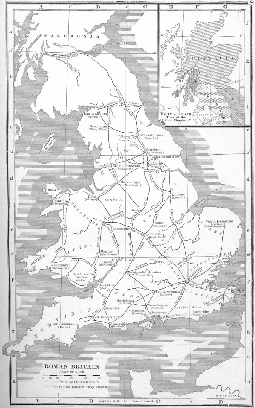
Icknield Street, also recorded as Ryknild Street in medieval sources, is a Roman-period road in Britain that runs roughly southwest–northeast from the Fosse Way at Bourton-on-the-Water to the Roman works at Templeborough. It is documented as one of the main arterial routes that linked military sites, towns and industrial centres during and after the Roman occupation. Modern descriptions often begin with a general notice of the route and its surviving fragments (overview sources).
Image gallery
10 Images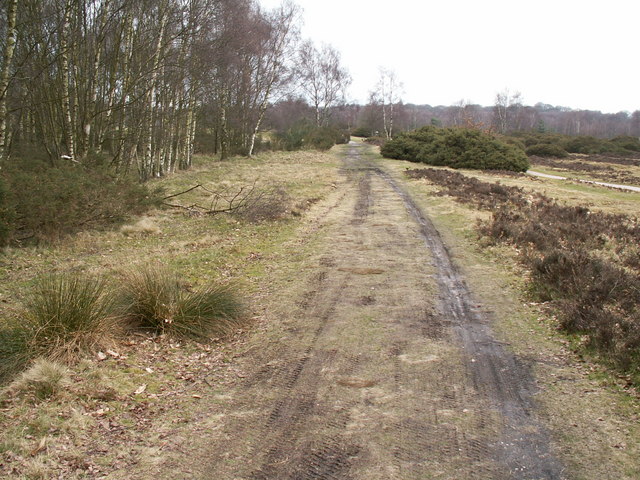


Route and principal places
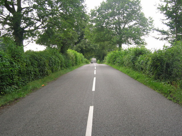
The road leaves the Fosse Way near Bourton on the Water and proceeds northeast, cutting across the English midlands. Along its course it passes through or near important settlements such as Alcester, the area of Birmingham, Lichfield and Derby, before reaching its terminal area at Templeborough near modern Rotherham. In places the Roman alignment can still be traced as aggers, holloways, or incorporated into later roads and property boundaries. Not every section survives: some stretches are visible as earthworks or within parks and commons, while others have been built over or ploughed away.
Physical characteristics and archaeology
As with many Roman roads, Icknield Street was engineered for directness and durability: a raised base (agger), cambered surface and layered surfacing of stones or compacted material where the terrain required. Excavations have revealed typical Roman construction techniques in several places, and archaeological finds along the route testify to roadside occupation, small settlements and industrial activity. A conspicuous surviving fragment is preserved in Sutton Park in Birmingham, where a length of the Roman alignment remains visible as a raised causeway. Such remnants are important for understanding road-building practices and the connectivity of Roman Britain.
Names, historic records and confusion with Icknield Way
The road appears in medieval lists of principal routes under several names. The Laws of Edward the Confessor name four principal roads, including an entry variously written as Hikenild or Icknield. Later chroniclers such as Ranulf Higdon (in the 14th century) called the route Rikenild Strete or Ryknild Street, describing a line that links points from the south-west toward the Tyne and passing through Worcester, Droitwich, Birmingham, Lichfield, Derby and Chesterfield. Medieval translations and manuscripts show variant spellings: Rikenilde, Rikenyldes, Hikenil and others. Antiquaries have long debated whether the name derives from tribal names such as the Iceni or from later medieval corruptions.
Distinction from the prehistoric Icknield Way
It is important to distinguish Icknield Street (the Roman road) from the much older Icknield Way, an Iron Age and prehistoric track that runs broadly between eastern counties and the south-west. The prehistoric Icknield Way is associated with long-distance prehistoric movement from Norfolk across the Chilterns into Dorset, and derives its character from ancient trackway use rather than Roman engineering. Confusion has persisted because medieval scribes and later writers sometimes used related or similar names (Icenhilde Weg, Hikenild Street), and some documents conflate different routes. Modern scholarship usually treats the Roman street and the prehistoric way as separate phenomena with overlapping but distinct histories; many guides and county histories emphasise the difference while noting the similarity of names.
Historical role and legacy
During the Roman period the road was a functional artery for troop movements, supply and communication between forts, industrial centres and towns. After the Roman withdrawal it continued to influence settlement patterns, medieval travel and later road alignments. Numerous market towns and later roads follow all or part of the Roman course. Today the alignment is of interest to archaeologists, local historians and recreational users: surviving stretches are managed as heritage features in parks and nature reserves, documented in county records and described in local walking guides and historic road studies (Watling Street and Ermine Street are examples of other Roman highways often discussed alongside Icknield Street).
Notable facts and resources
- The medieval name Ryknild (and many variant spellings) first appears in chronicled works such as the Polychronicon and later translations.
- Surviving earthworks in public parks, especially near Birmingham, provide accessible examples of Roman roadway construction.
- Scholars caution that historic place-names can mask earlier prehistoric routes; always check whether a source refers to the Roman street or the prehistoric way (Iron Age context).
For further reading consult regional archaeological reports and county histories that map the known fragments and discuss their preservation. Local museums and heritage bodies often hold artefacts recovered along the route and can offer detailed information about excavations and conservation projects (general reference).
Questions and answers
Q: What is Icknield Street or Ryknild Street?
A: Icknield Street or Ryknild Street is a Roman road in Britain that runs from the Fosse Way at Bourton on the Water in Gloucestershire to Templeborough in South Yorkshire. It passes through Alcester, Birmingham, Lichfield and Derby.
Q: What are the four Roman roads named in the Laws of Edward the Confessor?
A: The four Roman roads named in the Laws of Edward the Confessor are Watling Street, Ermine Street, the Fosse Way and Hikenild (or Icknield) Street.
Q: Where does Icknield Way run from?
A: Icknield Way runs from Norfolk to Dorset.
Q: Who named Ryknild Street during the 12th century?
A: Ryknild Street was named by Ranulf Higdon, a monk writing in 1344 in his Polychronicon.
Q: Is there any evidence of this road still existing today?
A: Yes, a kept part of this Roman road can be seen at Sutton Park in Birmingham.
Q: How did Harverfield refer to this road when writing for Victoria County History of Warwickshire?
A: When writing for Victoria County History of Warwickshire, Harverfield referred to this road as either "Ryknild" or "Icknield," preferring "Ryknild" as no less correct and being able to separate it from Icknield Way.
Related articles
Author
AlegsaOnline.com Icknield Street (Ryknild Street): Roman road from Bourton to Templeborough Leandro Alegsa
URL: https://en.alegsaonline.com/art/46483
Sources
- brrp.bham.ac.uk : Birmingham Roman Roads Project
- birmingham.gov.uk : Metchley Fort, Birmingham
- derby.gov.uk : Derby City Council list of Scheduled Ancient Monuments
- penelope.uchicago.edu : Full text of Roman Roads in Britain, Thomas Codrington
- gutenberg.org : An History of Birmingham (1783) by William Hutton