Hurricane Patricia (2015)
Hurricane Patricia (2015) was the most intense tropical cyclone recorded in the Western Hemisphere, rapidly reaching Category 5 with 215 mph winds before impacting Mexico's Pacific coast; the name was retired in 2016.
Overview
Hurricane Patricia was an exceptionally intense tropical cyclone in the eastern North Pacific during October 2015. It became the strongest hurricane on record in the Western Hemisphere, attaining sustained winds reported at 215 mph. Patricia tracked toward the Pacific coast of western Mexico, prompting widespread concern because of its rapid strengthening and potential for catastrophic impacts.
Image gallery
10 Images


Meteorological characteristics
Patricia developed from a tropical disturbance into a tropical storm and then underwent an unprecedented episode of rapid intensification, reaching Category 5 strength on the Saffir–Simpson scale. Observations and satellite estimates indicated a very compact, well-defined eye and extreme wind speeds near the center. The storm's rapid escalation in intensity over a short period drew attention from meteorologists and highlighted challenges in forecasting fast-changing tropical systems.
Impact and aftermath
Before reaching land, Patricia weakened from its peak intensity, but it still produced powerful winds, heavy rain, storm surge, and flash flooding when it struck coastal areas of Mexico. Local authorities issued evacuations and emergency declarations, and communities experienced damage to homes, roads, and agriculture. Recovery and relief efforts followed, focusing on restoring services and assisting affected residents. The storm's ultimate human and economic toll was limited relative to what might have occurred had the peak intensity been sustained to landfall, though serious local impacts were reported.
Records, significance and name retirement
Patricia is notable for setting intensity records for the hemisphere and for illustrating both the dangers of rapid intensification and the importance of timely preparedness. It was described in relation to previous intense eastern Pacific storms, such as Hurricane Linda (1997), and its exceptional peak made it a frequent reference point in scientific and public discussions about extreme tropical cyclones. On April 25, 2016, the World Meteorological Organization retired the name Patricia from the rotating list of Pacific hurricane names and replaced it with Pamela for future seasons.
Notable facts
- Peak sustained winds widely reported at 215 mph, making Patricia the strongest recorded in the Western Hemisphere.
- Characterized by an unusually rapid intensification prior to its peak.
- The storm weakened before landfall but still produced damaging winds and heavy rainfall in affected coastal areas.
- The name Patricia was retired in 2016 and replaced with Pamela.
For more technical or historical details about Hurricane Patricia, consult meteorological summaries and post-storm reports that analyze its development, impacts, and the forecasting challenges it presented.
History
On 14 October, the National Hurricane Center (NHC) began monitoring a possible tropical cyclogenesis over the easternmost part of the Pacific Ocean, not far from the Gulf of Tehuantepec, as a depression was expected to form. The system consolidated on 17 October under the influence of a large area of atmospheric convective precipitation and thunderstorms that extended westward from Central America for several hundred kilometers over open water. Conditions were favorable for the system to develop, the depression continued to organize steadily, and convection became more concentrated around its center.
Interaction with a Tehuano wind event on 18 October delayed the development of the tropical disturbance into a tropical depression. Controlled by a meteorological ridge over the Gulf of Mexico, the system drifted west-southwestward and continued to consolidate on 20 October. By 15:00 UTC, convection had increased to the point that it was declared Tropical Depression Twenty-E. At this time, the system was located 715 km east-southeast of Acapulco.
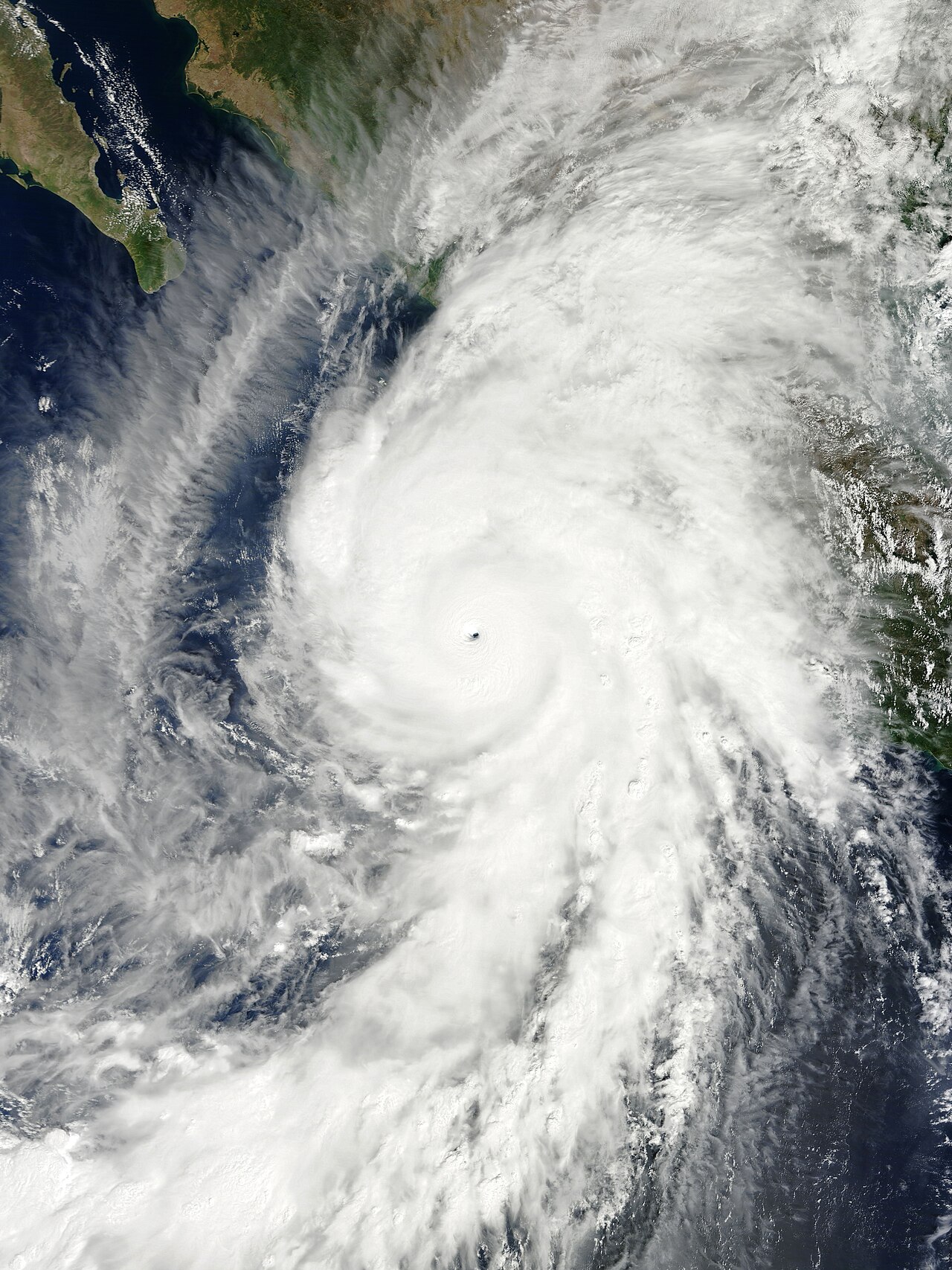
The coincidence of exceptional atmospheric conditions - low wind shear, water surface temperatures above 30 °C, and high humidity - favored rapid intensification. The system was therefore able to intensify into a tropical storm, at 03:00 UTC the storm name Patricia was assigned. For reasons still unknown, the system seemed to partially dissipate during the day: Rain bands disappeared and the near-surface circulation was poorly defined. This phase lasted only briefly, however; late on 21 October, convection blossomed and a Central Dense Overcast formed over the center of the storm. Early on 22 October an eye was then visible. The system reached hurricane strength by 09:00 UTC and was now forming a clearly visible outflow as well as well-defined band structures. The intensification continued rapidly. Data collected by Hurricane Hunters during the Patricia investigation indicated that Patricia reached SSHS Category 4 at 18:00 UTC.
During the morning hours of 23 October, a ring of clouds surrounded the hurricane, with cloud top temperatures of -90°C. This, along with the 17 km diameter eye, signaled the hurricane's intensification into Category 5. Based on satellite analysis, it was estimated that Patricia reached maximum one-minute wind speeds of 260 km/h and an atmospheric pressure of 924 hPa. In a span of 24 hours, Patricia's wind speeds increased by 155 km/h. This rate of intensification is greater than that of any other Pacific Ocean hurricane recorded since satellite observations began - only Hurricane Linda intensified at a similar rate in 1997. Around 05:30 UTC, a wind speed of 332 km/h was measured at flight level during a reconnaissance flight into the hurricane. With this measurement data, the speed at the surface was estimated to be 295 km/h, with a central air pressure of 892 mbar. This made Patricia the most intense hurricane in the eastern Pacific in terms of atmospheric pressure and also, along with Hurricane Linda, the highest wind strength.
Patricia continued to deepen while the reconnaissance flight continued. The last observations before the Hurricane Hunters left the hurricane showed that the hurricane had become the strongest tropical cyclone in the Western Hemisphere. According to the report, Patricia reached sustained one-minute winds of 325 km/h and an atmospheric pressure of 879 mbar. The previous record was 882 hPa and was set in 2005 by Hurricane Wilma in the Atlantic Ocean. At the altitude of the exploratory flight, the wind speed was 356 km/h. The sustained wind speeds thus reached values that are among the highest wind speeds ever reliably recorded on Earth. They also exceeded the values determined in 2013 during Typhoon Haiyan, which are based on satellite observations (due to different determination methods, it is unclear which are actually the highest).
The storm maintained its 325 mph winds for several hours before clouds filled the eye late on 23 October and weakening began. This continued as Patricia moved closer to the Mexican coast. At 23:15 UTC on 23 October, the hurricane made landfall in the vicinity of La Huerta and Cihuatlán in the state of Jalisco with winds of 265 km/h, making Patricia the first hurricane to strike the Mexican Pacific coast in this category since the 1959 Mexico Hurricane. However, the status of the unnamed 1959 hurricane is in dispute, and it may have been weaker than it was classified after the SSHS was implemented.
The hurricane crossed the Sierra Madre del Sur on 24 October, weakening very rapidly; the eye of the hurricane disappeared from satellite imagery within hours of the hurricane making landfall. Patricia's inland track accelerated as the storm was sandwiched between a trough over northwestern Mexico and a ridge over the Gulf of Mexico. The convection rapidly lost its organization, and circulation near the ground and at mid to high altitudes detached from the center of the convection. At 15:00 UTC on 24 October, Patricia was downgraded to a tropical depression because little convection remained.


Preparations
Tourists in coastal areas were evacuated by bus. In the states of Michoacán, Colima, Jalisco and Nayarit, a total of 1782 emergency shelters were set up on 22 October to accommodate up to 258,000 people. Authorities in Manzanillo began distributing sandbags the same day, and school classes were suspended in the state of Jalisco a day later.
| Pacific Category 5 Hurricanes | |
| Name | Season |
| Patsy | 1959 |
| "Mexico" | 1959 |
| Ava | 1973 |
| Emilia | 1994 |
| Gilma | 1994 |
| 1994 | |
| Guillermo | 1997 |
| 1997 | |
| Elida | 2002 |
| Hernan | 2002 |
| 2002 | |
| Ioke | 2006 |
| Rick | 2009 |
| Celia | 2010 |
| Patricia | 2015 |
Related articles
Author
AlegsaOnline.com Hurricane Patricia (2015) Leandro Alegsa
URL: https://en.alegsaonline.com/art/45968
Sources
- foxnews.com : "Patricia Grows Stronger"