Hurricane Maria (2017)
Powerful 2017 Atlantic hurricane that rapidly intensified to Category 5, made catastrophic landfalls in Dominica and Puerto Rico, and had its name retired due to severe loss and destruction.
Hurricane Maria was a powerful and destructive tropical cyclone in the 2017 Atlantic hurricane season. It formed from an easterly wave that moved off the west coast of Africa and developed into a tropical cyclone over the central Atlantic Ocean. As part of the busy 2017 Atlantic hurricane season, Maria became the thirteenth named storm and the eighth hurricane of that year before undergoing rapid intensification.
Image gallery
10 Images


Formation and meteorological history
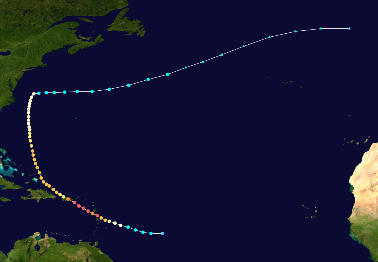
Maria organized quickly after becoming a tropical storm east of the Lesser Antilles on September 16, 2017. In the days that followed it intensified to major hurricane strength and reached Category 5 intensity at peak. The cyclone maintained a compact, well-defined eyewall as it approached the eastern Caribbean, then made its first significant impact when it came ashore on the island of Dominica on September 18. After crossing the eastern Caribbean, the storm tracked toward Puerto Rico and other nearby islands.
Impacts and consequences
Maria produced catastrophic wind, storm surge, and rainfall impacts across several islands. It destroyed homes, uprooted trees, and caused widespread flooding. In Puerto Rico, the storm precipitated an extended and severe loss of electrical service, extensive damage to housing and infrastructure, and long-term disruption to water, transportation and communications systems. Other affected areas included Dominica, the U.S. Virgin Islands, and portions of the Greater Antilles, where communities suffered major economic and agricultural losses.
Humanitarian response and recovery
The event prompted large-scale emergency responses from governments, aid organizations and local agencies. Relief efforts focused on restoring power, delivering food and medical supplies, repairing infrastructure, and addressing public health risks. Recovery required months to years in some areas, with rebuilding complicated by terrain, resource constraints and preexisting vulnerabilities.
Notable facts and legacy
- Maria was among the most intense tropical cyclones worldwide in 2017 and is remembered for its rapid intensification and destructive landfalls.
- The storm's impacts, particularly in Puerto Rico, led the World Meteorological Organization to retire the name Maria. It was replaced in later naming lists.
- Maria is commonly referenced in discussions of storm preparedness, infrastructure resilience and the challenges of post-disaster recovery in island environments.
Distinctions and wider context
Unlike many slower-moving hurricanes, Maria's rapid strengthening highlighted forecasting challenges associated with rapid intensification. It also underscored how powerful storms can compound preexisting social and economic stresses in affected areas. For more detailed meteorological data, storm track maps, and post-storm assessments, see contemporary reports and technical summaries produced by meteorological agencies and disaster-response organizations.
Sources and further reading include regional meteorological summaries and post-event assessments from agencies and research institutions; for general context see summaries of the 2017 Atlantic hurricane season and archival material on storm advisories and landfall reports such as those documenting Maria's landfall sequence and impacts across the eastern Caribbean islands.
Meteorological history
The National Hurricane Center (NHC) began observing two tropical waves on September 13. The more easterly of these rapidly developed into the system that eventually formed Hurricane Lee, while the more westerly moved in a generally westerly direction across the tropical Atlantic. Conditions in the disturbance's track were generally favorable, and development into a tropical cyclone system seemed likely. During the following two days, the disturbance became better organized, and by 15:00 UTC on 16 September, the organization had increased to the point where the system was classified as a potential tropical cyclone. A subtropical high-pressure ridge lying to the north of the disturbance steered it in a generally west-northwesterly direction into an environment very favorable for further development. Water surface temperatures of 29 °C, a low wind shear and abundant moist air were the basis for the system to intensify into a hurricane before reaching the Lesser Antilles. As the day progressed, the system continued to organise and, based on satellite data, was upgraded to a moderately strong tropical storm at 21:00 UTC and named Maria.
A dense Central dense overcast (CDO) and beneficial outflow formed over the center of circulation, further favoring Maria's development during the morning hours of 17 September. After dry air briefly entered the system and cleared the circulation, convection broke out over the center and intensification continued. During the day, the storm was upgraded to a hurricane at 21:00 UTC on 17 September based on reports from Hurricane Hunters, who investigated it and found surface winds of 119 km/h and a forming eye. Cloud cover expansion and an increasingly complete eyewall signaled steady intensification during the night of 17-18 September.
Early on 18 September, considerable thunderstorm activity was evident within the core, and statistical models suggested that rapid intensification was imminent. In fact, explosive intensification occurred shortly thereafter, and a reconnaissance flight detected surface winds of 193 km/h and a central pressure of 959 mbar, making Maria a Category 3 severe hurricane on the Saffir-Simpson hurricane wind scale. In addition, radar data revealed a well-defined eye with a diameter of 19 km. The eye meanwhile contracted slightly to a diameter of 15 km as intensification continued and the system reached Category 4 at 21:00 UTC.
| The most intense Atlantic hurricanes | |||
| Rank | Hurricane | Season | |
| 1 | 2005 | 882 | |
| 2 | 1988 | 888 | |
| 3 | "Labor Day" | 1935 | 892 |
| 4 | 2005 | 895 | |
| 5 | 1980 | 899 | |
| 6 | 1969 | 900 | |
| 7 | 2005 | 902 | |
| 8 | 1998 | 905 | |
| 2007 | 905 | ||
| 10 | Maria | 2017 | 908 |
| Source: HURDAT | |||
The rapid intensification peaked late on 18 September, when Maria intensified into a Category 5 hurricane just 25 km east-southeast of Dominica.
At 01:15 UTC on 19 September, the eye of a Category 5 hurricane struck the coast of the island of Dominica for the first time. Interaction with the land caused Maria to weaken slightly into a hurricane at the upper end of Category 4, but shortly after the eye was back over water, Maria reacquired Category 5 hurricane status. Despite the formation of concentric eyewalls - the larger 40-55 km in diameter and the smaller 8 km in diameter (indicating the onset of cyclic eyewall reformation) - the inner core remained unaffected during the afternoon. Maria reached peak intensity at about 03:00 UTC on 20 September, about 45 km south of Saint Croix, with sustained winds of 280 km/h and a central atmospheric pressure of 908 mbar; the atmospheric pressure is the tenth lowest of any tropical cyclone in the Atlantic basin since reliable records began.
The hurricane made its closest approach to St. Croix at about 05:00 UTC on 20 September; it passed within 30 km of the island, and the outer eyewall of the hurricane grazed the island while the strongest winds remained offshore. Hours later, at about 08:00 UTC, the outer eyewall struck Vieques Island east of Puerto Rico. At this time, the outer eyewall began to dominate and the inner eyewall faded, and as a result of eyewall renewal, Maria weakened to Category 4. At about 10:15 UTC, the center of Maria crossed the coast of Puerto Rico just south of Yabucoa with sustained winds of 250 km/h (155 mph); this made Maria the strongest hurricane to hit Puerto Rico since San Felipe Segundo in 1928. Over Puerto Rico, Maria maintained a roughly west-northwesterly course and reached the waters of the open Atlantic shortly before 18:00 UTC. Due to the mountainous topography on InseI, Maria had lost significant strength over Puerto Rico, and persistent wind speeds decreased to 175 km/h, while core pressure had increased to 957 mbar. Due to continued favorable ambient conditions, Maria steadily reorganized. As the hurricane moved away from Puerto Rico, a large eye 75 km in diameter formed around which deep convection flourished. Early on 21 September, the system again reached Category 3.
The water surface stirred up by Hurricane Irma initially limited Maria's reorganization. On the afternoon of 21 September, the system crossed Navidad and Silver Banks north of the Dominican Republic. Shoaling due to shallow water depths interfered with measurements of near-surface wind speeds. Convection around the eye deepened and the eye became better defined during the night, and the hurricane reached a tertiary peak with sustained winds of 205 km/h.
An additional increase in southwesterly wind shear led to the gradual weakening of the hurricane with a decrease in band structures and later degradation of the eye. Late on 22 September, the hurricane turned to its expected north-northwesterly track, having reached the western edge of the ridge that had previously blocked its path northward and steered the hurricane westward because of it. Maria's degree of organization alternately decreased and increased through 23 September, and the eye filled with clouds and cleared again; during this phase, Maria remained in Category 3. Despite a decrease in central pressure, the hurricane weakened to Category 2 early on 24 September. Hurricane Hunters observed wind speeds of 187 to 217 km/h at flight level; however, wind speeds determined by NASA's Stepped-Frequency Microwave Radiometer only reached 150 km/h. At this point, Maria's track swung northward toward the aforementioned ridge and a cut-off low over the eastern Gulf of Mexico.
The further track until 27 September ran east of the Bahamas and east of the east coast of the USA in a northerly direction. In the process, Maria weakened to a tropical storm.
The remnants of the hurricane also reached the Alps on 3 October 2017, and in the form of a weak cold front also Austria, there especially the north of the country.


Preparations
After the National Hurricane Center began issuing warnings on September 16 about the system that would develop into Tropical Storm Maria, the government of France issued storm warnings for Martinique and Guadeloupe; similarly, the governments of Saint Lucia did so for their citizens and Barbados did so for residents of Dominica. Barbados later extended the advance warnings to residents of Barbados and Saint Vincent and the Grenadines. The government of Antigua and Barbuda issued hurricane warnings for the islands of Antigua, Barbuda, Saint Kitts, Nevis, and Montserrat when the NHC declared Maria a tropical storm. For Puerto Rico, the government ordered evacuations and announced the opening of 450 shelters beginning September 18. In addition to a storm warning, a flood warning was also issued for rivers such as the Rio de la Plata, with levels rising sharply.
.Questions and answers
Q: What was Hurricane Maria?
A: Hurricane Maria was a hurricane of notable status that began in the Atlantic Ocean and was part of the 2017 Atlantic hurricane season. It was the most intense tropical cyclone worldwide in 2017.
Q: When did it originate?
A: Hurricane Maria originated from easterly waves off the west coast of Africa on September 16.
Q: How strong was it when it made landfall?
A: When it made landfall, Hurricane Maria had intensified to Category 5 strength.
Q: Where did it make landfall?
A: Hurricane Maria made landfall in Dominica on September 18.
Q: Was its name retired after its destruction?
A: Yes, due to the large number of deaths and destruction in Puerto Rico, the World Meteorological Organization retired the Maria name in April 2018 and replaced it with Margot for the 2023 Atlantic hurricane season.
Related articles
Author
AlegsaOnline.com Hurricane Maria (2017) Leandro Alegsa
URL: https://en.alegsaonline.com/art/45951
Sources
- nytimes.com : "Hurricane Maria Hits Puerto Rico"
- cbsnews.com : "Hurricane Maria caused an estimated 2,975 deaths in Puerto Rico, new study finds"