Hurricane Erika (2003) — Gulf of Mexico hurricane near the Texas–Tamaulipas border
Overview, meteorological history, impacts and response related to Hurricane Erika (2003), a hurricane that formed in the eastern Gulf of Mexico and struck northeastern Mexico near the Texas–Tamaulipas border.
Hurricane Erika was an Atlantic storm that developed in mid‑August 2003 and made landfall near the Texas–Tamaulipas border. The system is notable as the eighth tropical cyclone, fifth tropical storm, and third hurricane of the 2003 Atlantic hurricane season. It formed from a broader low‑pressure area tracked for several days before acquiring tropical characteristics.
Image gallery
8 Images


Meteorological history
The disturbance began as a non‑tropical area of low pressure that forecasters monitored while it moved across warm waters. After about five days of organization, the low strengthened in the eastern Gulf of Mexico and was declared tropical on August 14. Steering currents associated with a nearby high pressure system pushed the storm quickly westward. Under favorable conditions the system intensified and reached hurricane status before reaching the coast. The genesis from a non‑tropical low highlights how mid‑latitude features can transition into tropical systems when sea‑surface temperatures and atmospheric patterns permit.
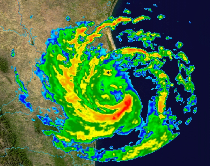
Characteristics and landfall
Erika exhibited the typical structure of a compact tropical cyclone, with a central area of stronger winds and bands of showers feeding into the center. Forecasters classified it as a tropical cyclone once sustained deep convection persisted. The storm’s landfall occurred in extreme northeastern Mexico near the border with Texas and the Mexican state of Tamaulipas, bringing heavy rain, gusty winds, and localized coastal flooding.
Impact and response
Authorities issued watches and warnings for coastal areas and arranged precautions for communities at risk. Typical impacts from such a landfall include heavy rainfall that can cause flash flooding, minor to moderate wind damage to structures and trees, and storm surge along low‑lying shores. Emergency services focused on public safety, road clearing, and restoring utilities where outages occurred.
Aftermath and significance
After moving inland, Erika weakened over terrain and dissipated, leaving behind localized flooding and recovery operations. The storm is remembered as a late‑season example of how a non‑tropical feature can evolve into a hurricane in the Gulf of Mexico. It also served as a reminder for coastal communities to heed forecasts and maintain preparedness for rapidly developing storms.
- Atlantic hurricane context: Erika was part of an active seasonal pattern.
- Origin: tracked from a non‑tropical low pressure area before tropical development.
- Steering: moved west under the influence of a high pressure system.
Questions and answers
Q: What was Hurricane Erika?
A: Hurricane Erika was an Atlantic hurricane that hit northeastern Mexico near the Texas-Tamaulipas border on August 16, 2003.
Q: What season did Hurricane Erika occur in?
A: Hurricane Erika occurred during the 2003 Atlantic hurricane season.
Q: What kind of storm was Hurricane Erika?
A: Hurricane Erika was the third hurricane, fifth tropical storm, and eighth tropical cyclone of the 2003 Atlantic hurricane season.
Q: How was Hurricane Erika formed?
A: Hurricane Erika was created from a non-tropical area of low pressure that was tracked for five days before developing in the eastern Gulf of Mexico on August 14.
Q: What caused Hurricane Erika to become stronger?
A: Under the influence of a high pressure system, Hurricane Erika moved quickly westward and became stronger under favorable conditions.
Q: When did Hurricane Erika hit northeastern Mexico?
A: Hurricane Erika hit northeastern Mexico near the Texas-Tamaulipas border on August 16, 2003.
Q: Where did Hurricane Erika develop?
A: Hurricane Erika developed in the eastern Gulf of Mexico.
Related articles
Author
AlegsaOnline.com Hurricane Erika (2003) — Gulf of Mexico hurricane near the Texas–Tamaulipas border Leandro Alegsa
URL: https://en.alegsaonline.com/art/45874
Sources
- nhc.noaa.gov : "Hurricane Erika Tropical Cyclone Report"
- nhc.noaa.gov : "Tropical Storm Erika Discussion One"
- hpc.ncep.noaa.gov : "Rainfall Data for Hurricane Erika"