Hurricane Cindy (2005)
A short‑lived late‑June/early‑July 2005 storm that became a Category 1 hurricane before striking southern Louisiana; notable for heavy rains, widespread outages and a powerful tornado from its remnants.
Hurricane Cindy was a tropical cyclone in early July 2005 that briefly attained minimal Category 1 hurricane intensity over the Gulf of Mexico and made landfall along the coast of Louisiana. It was the third named storm and the first hurricane of the active 2005 Atlantic hurricane season. Operationally assessed as a strong tropical storm, Cindy was later upgraded in the post‑storm analysis to a Category 1 hurricane, reflecting its short period at hurricane strength and the limited window for observation.
Image gallery
8 Images


Meteorological history
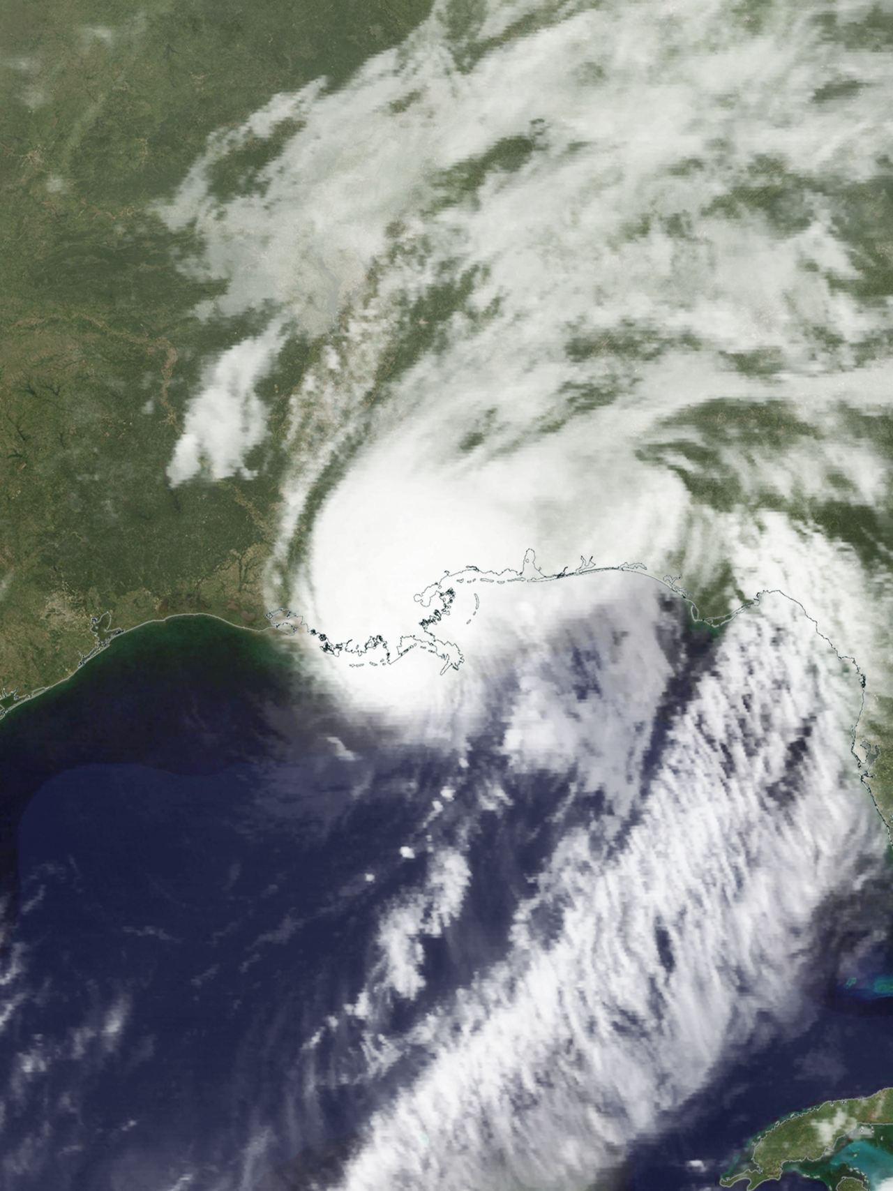
The system that became Cindy first organized on July 3, 2005, just east of the Yucatán Peninsula in the Caribbean Sea. It initially developed as a tropical depression and quickly moved inland over the peninsula, where its circulation weakened. After emerging into the Gulf of Mexico on July 4, environmental conditions allowed the cyclone to restrengthen as it tracked northward. By the time it approached the northern Gulf Coast, winds had increased enough for the system to be classified as a hurricane in later analysis. Cindy made landfall in southern Louisiana on July 5 and then weakened as it moved inland, becoming an extratropical system on July 7 as it lost tropical characteristics and merged with midlatitude weather features (extratropical).
Impacts and effects
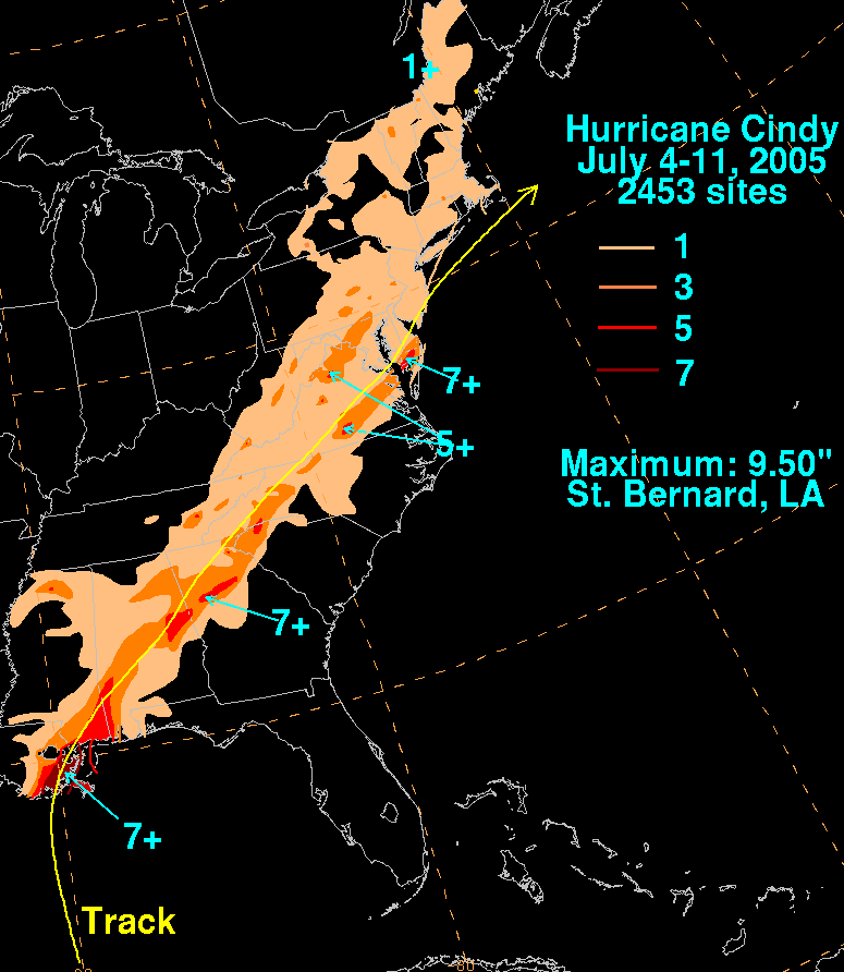
Cindy produced heavy rainfall across a broad area of the southeastern United States, leading to flooding and localized damage. The storm was linked to three fatalities in the United States, and it brought notable rainfall to coastal and inland portions of Louisiana, Mississippi, Alabama, and as far north as Maryland. In New Orleans and nearby communities, flooding and widespread power outages occurred; these disruptions briefly tested local emergency systems and public awareness ahead of later storms.
One of Cindy’s more unusual effects was the generation of a strong tornado from its remnants. A tornado rated an F2 in intensity developed and caused considerable damage in Hampton, Georgia, illustrating that even relatively weak tropical cyclones or their decaying remnants can produce violent tornadic events (tornado).
Preparations, response and aftermath
Authorities along the Gulf Coast issued warnings and urged preparedness as Cindy approached, including local evacuations in vulnerable coastal areas and shutdowns of some offshore operations. After landfall, emergency crews focused on restoring power, clearing debris and assisting flood‑affected residents. Damage from Cindy was modest compared with the catastrophic storms that followed later in 2005, but it served as a reminder of the hazards posed by short‑lived hurricanes and heavy tropical rainfall.
Notable aspects and legacy
Cindy is often noted for being the first storm of 2005 to reach hurricane strength, albeit briefly, and for the post‑season re‑analysis that revised its peak intensity upward from a tropical storm to a Category 1 hurricane. It occurred early in what became one of the most active and destructive Atlantic seasons on record. The storm’s effects — power outages, coastal flooding and an associated F2 tornado — underscored the variety of threats tropical cyclones pose beyond wind alone. Cindy’s occurrence a few weeks before Hurricane Katrina contributed to heightened public attention on hurricane preparedness along the Gulf Coast in the summer of 2005.
- Dates: Formed July 3, 2005; landfall July 5; became extratropical July 7.
- Region affected: Northern Caribbean, Gulf of Mexico coast, southeastern United States.
- Human impacts: Several fatalities and localized flooding and damage.
- Scientific note: Upgraded to Category 1 in post‑storm analysis of the 2005 season.
Questions and answers
Q: What was Hurricane Cindy?
A: Hurricane Cindy was a tropical cyclone that reached minimal hurricane strength for a very short time in the Gulf of Mexico during July and made landfall in Louisiana. It was the third named storm and first hurricane of the 2005 Atlantic hurricane season.
Q: Where did Hurricane Cindy form?
A: Hurricane Cindy formed on July 3 just east of the Yucatán Peninsula in the Caribbean Sea.
Q: When did it make landfall?
A: The storm soon made landfall on the Yucatán Peninsula and weakened before entering in the Gulf of Mexico on July 4, then became a hurricane just before making landfall on southern Louisiana on July 5.
Q: How many deaths were caused by Hurricane Cindy?
A: Hurricane Cindy was responsible for a total of 3 deaths in the United States.
Q: What other effects did it have?
A: In addition to causing fatalities, Hurricane Cindy brought heavy rains to Louisiana, Mississippi, Alabama and Maryland, caused flooding and a very big blackout in New Orleans, Louisiana, as well as an unusually strong F2 tornado which caused damage in Hampton, Georgia.
Q: How did this event influence people's reactions when Katrina struck later that year?
A: The flooding and blackout caused by Hurricane Cindy encouraged people to evacuate when Katrina destroyed New Orleans later that month.
Related articles
Author
AlegsaOnline.com Hurricane Cindy (2005) Leandro Alegsa
URL: https://en.alegsaonline.com/art/45851
Sources
- nhc.noaa.gov : "Tropical Cyclone Report: Hurricane Cindy"
- nhc.noaa.gov : "Discussion for Tropical Depression Three, 11 p.m. EDT, July 3 2005"
- nhc.noaa.gov : "Discussion for Tropical Depression Three, 5 p.m. EDT, July 4 2005"
- nhc.noaa.gov : "Discussion for Tropical Storm Cindy, 11 p.m. EDT, July 5 2005"
- bjandtony.com : "The Adventures of BJ and Tony Morris - New Orleans, Louisiana"
- 72.14.209.104 : "Seebach: Repair the marshlands or rebuild New Orleans"