
Houten — Dutch commuter town known for planned design and cycling infrastructure
Houten is a municipality in Utrecht province, Netherlands, noted for its planned expansion, extensive bicycle infrastructure, commuter links to Utrecht, and the relocation of its historic station building.

Overview
Houten is a town and municipality in the province of Utrecht in the Netherlands. Historically a small village, it was expanded in the later 20th century as a planned commuter town with a strong focus on residential quality and sustainable local mobility. Around 2007 the town’s population was roughly 45,000; municipal planning documents and past proposals discussed further growth in subsequent years. Many residents travel daily to Utrecht for work and study, and the town functions as a suburban centre with an emphasis on local services and green space.
Image gallery
9 Images


Urban design and cycling infrastructure

Houten is widely discussed in urban planning and transport literature because of its deliberate layout that prioritises cyclists and pedestrians. The town was developed with a hierarchy of roads that separates local access streets from through-routes for motor traffic. Key elements of the urban design include:
- Extensive, segregated cycleways that provide direct connections between neighbourhoods, schools and shops, reducing the need for short car trips.
- A ring road for motor traffic that directs longer-distance and through-traffic around residential areas rather than through them.
- Compact neighbourhood centres where daily shopping, primary schools and small parks are within easy walking or cycling distance.
The result is generally quieter residential streets, safer routes for children and a public realm oriented toward human-scale mobility. Planners often study Houten as an example of how network design and local policies can influence travel patterns.
Transport and the railway
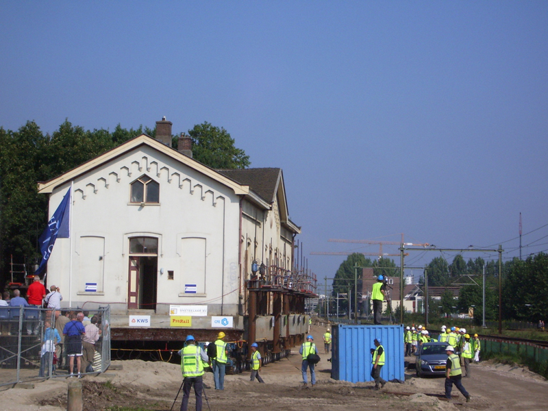
Houten sits on a regional railway corridor linking Utrecht with towns to the southeast. The station provides regular commuter services that shape daily travel to and from the city of Utrecht and other regional destinations. A widely noted engineering and heritage intervention in the town’s recent history was the relocation of an older station building in order to allow track upgrades and improved rail operations; the building was lifted and moved to new foundations to preserve it while the line was modernised. For timetable information, local route maps and regional planning resources see provincial or national sources and the local railway service pages.
History and development
Archaeological finds indicate human presence in the Houten area since Roman times, and the settlement remained a small agricultural village for many centuries. Significant change came in the late 20th century when national and municipal policies encouraged suburban expansion in the Utrecht region. New residential districts, schools, sports facilities and community services were added in planned phases to accommodate commuting families while attempting to preserve local identity and green corridors.
Economy, services and community life
Houten’s local economy is primarily service-oriented, with retail, education, healthcare and small business forming most local employment. Because of its proximity to Utrecht many residents work outside the municipality, creating a commuter profile typical of suburban towns close to a larger city. The town offers playgrounds, sports clubs, cultural activities and parks, and municipal planning emphasises a mix of housing types and community amenities.
Planning, recognition and challenges
Houten is often cited internationally as an illustrative case for bicycle-centred suburban design and for applying street hierarchy to reduce through-traffic. Its successes include high rates of cycling for short trips and relatively safe local streets; challenges noted by planners include managing incremental growth, ensuring affordable housing choices, and maintaining public transport capacity as the region evolves. For demographic and statistical references see regional population data and local planning reports available through municipal or statistical services, for example population statistics.
Further information
Visitors and researchers interested in Houten’s planning model can consult provincial resources for Utrecht, national overviews for the Netherlands, and local transport providers for up-to-date rail information at the regional railway. Historical summaries and municipal services are published by the town council and local archives.

Questions and answers
Q: What is the population of Houten?
A: The population of Houten in 2007 was about 45,000.
Q: What railway line does Houten lie on?
A: Houten lies on the railway line from Utrecht to Tiel and 's Hertogenbosch.
Q: How was the old station building moved in 2004?
A: In 2004, the old station building was lifted off its foundations and moved a few hundred metres to new foundations.
Q: Where do many people living in Houten have jobs?
A: Many people living in Houten have jobs in Utrecht.
Q: When is it planned that the city should reach 50,000 people?
A: According to plans of the government, the city should grow to about 50,000 people by 2010.
Q: How long has there been human activity in this area?
A: People have lived in this area since Roman times.
Related articles
Author
AlegsaOnline.com Houten — Dutch commuter town known for planned design and cycling infrastructure Leandro Alegsa
URL: https://en.alegsaonline.com/art/45383