Ansbach
![]()
Anschba is a redirect to this article. For the Russian tennis player see Amina Vladikovna Anshba.
![]()
This article describes the district capital of Middle Franconia in Bavaria. For other meanings, see Ansbach (disambiguation).
Ansbach (![]() , East Franconian: Anschba) is a district-free city in Bavaria and belongs to the planning region of West Middle Franconia and the metropolitan region of Nuremberg. Ansbach is the fourth largest city in Middle Franconia with over 40,000 inhabitants. It is the seat of the government and the district administration of Middle Franconia as well as the district office of Ansbach. In earlier times, it was called "Onolzbach" or "Onoldsbach", as the Onolzbach stream still is today.
, East Franconian: Anschba) is a district-free city in Bavaria and belongs to the planning region of West Middle Franconia and the metropolitan region of Nuremberg. Ansbach is the fourth largest city in Middle Franconia with over 40,000 inhabitants. It is the seat of the government and the district administration of Middle Franconia as well as the district office of Ansbach. In earlier times, it was called "Onolzbach" or "Onoldsbach", as the Onolzbach stream still is today.

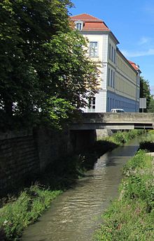
Franconian Rezat in Ansbach, along the Residence

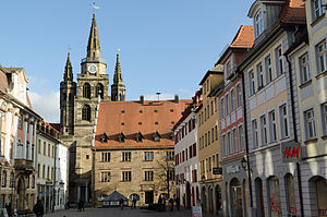
Martin-Luther-Platz with view of St. Gumbertus, town hall, Margrave-Georg-Fountain and town hall
Geography
Geographical position
The city is located about 40 kilometers southwest of Nuremberg on the tributary of the Onolzbach into the Franconian Rezat, which ultimately drains to the Main. In terms of area, it is the fifth largest city in the Free State of Bavaria, behind Munich, Nuremberg, Augsburg and Ingolstadt.
Neighboring communities
The communities bordering the city area are all in the district of Ansbach:
| Lehrberg | Weihenzell | |
| Leutershausen |
| Petersaurach, Saxony near Ansbach |
| Herrieden | Burgoberbach | Lichtenau, Weidenbach |
Community structure
→ Main article: List of places in the independent city of Ansbach
The political municipality of Ansbach has 54 municipal districts (the settlement type is indicated in brackets):
- Ansbach (main town)
- Aumühle (wasteland)
- Bernhardswinden (village)
- Brodswinden (Pfarrdorf)
- Claffheim (village)
- Dautenwinden (village)
- Deßmannsdorf (village)
- Dombach in the hole (village)
- Dornberg (village)
- Egloffswinden (village)
- Elpersdorf b.Ansbach (parish village)
- Eyb (parish village)
- Fish House
- Galgenmühle (village)
- Geisengrund (village)
- Gösseldorf (village)
- Hammerschmiede (Wasteland)
- Way home (old people's home)
- Hennenbach (village)
- Höfen (village)
- Höfstetten (village)
- High spruce (hamlet)
- Höllmühle (wasteland)
- Beetle brook (village)
- Kaltengreuth (village)
- Kammerforst (village)
- Katterbach (village)
- Kurzendorf (village)
- Liegenbach (hamlet)
- Louis mill (wasteland)
- Meinhardswinden (parish village)
- Mittelbach (village)
- Neudorf (village)
- Neuses b.Ansbach (village)
- Oberdombach (village)
- Obereichenbach (village)
- Pfaffengreuth (village)
- Rabenhof (Wasteland)
- Schalkhausen (parish village)
- Scheermühle (wasteland)
- Schockenmühle (wasteland)
- Steinersdorf (village)
- Strüth (village)
- Untereichenbach (village)
- Fulling mill (wasteland)
- Wallersdorf (village)
- Wasserzell (village)
- Vineyard (Wasteland)
- Wengenstadt (village)
- Windmill b.Elpersdorf (village)
- Windmill b.Pfaffengreuth (wasteland)
- Winterschneidbach (village)
- Wolfartswinden (village)
- Wüstenbruck (village)
The Galgenmühle and Kammerforst have meanwhile been absorbed into the district of Ansbach, the Hammerschmiede into the district of Wallersdorf, Kaltengreuth and Pfaffengreuth into the district of Eyb. Ansbach forms a closed settlement with Eyb, Hennenbach, Neuses and Schalkhausen.
The villages Aub, Käfermühle, Mittelmühle and Obermühle belong to the district Käferbach, the Brodswindener Mühle to Brodswinden, the Höfstetter Mühle to Höfstetten, the Neudorfer Mühle to Neudorf, the Untereichenbacher Mühle to Untereichenbach, the Wasserzeller Mühle to Wasserzell, Ober- and Unterdautenwinden as well as the Höfstetter Mühle form the district Dautenwinden.
The villages Fallhaus, Voggenhof, Voggenmühle, Weidenmühle and Ziegelhütte were located on the municipal territory. In the meantime they are all deserted.
Climate
Due to its location in Central Europe, Ansbach is in the cool temperate climate zone. The town lies in the transitional area between the humid Atlantic and the dry continental climate.
| Average temperature and precipitation values from 1981 to 2010
Source: © Private weather station Ansbach-Schalkhausen, measuring station of the DWD since 1986. | |||||||||||||||||||||||||||||||||||||||||||||||||||||||||||||||||||||||||||||||||||||||||||||||||||||||||||||||||||||||||||||||||||||||||||||||||||||||||||||||||||||||||||||||||
Search within the encyclopedia
.svg.png)