Hille (Minden-Lübbecke), North Rhine-Westphalia, Germany
Hille is a municipality in Minden-Lübbecke, North Rhine-Westphalia. Formed in 1973, it spans low North German Plain and the Wiehengebirge foothills and combines agriculture, light industry and canal transport.
Overview
![]() Hille is a rural municipality in the district of Minden-Lübbecke, located in the northeastern part of North Rhine-Westphalia, Germany. It was created in the municipal reorganization of 1973 by merging nine smaller communities and takes its name from the central village of Hille. Today the municipality covers about 102.99 km² and has a population of roughly 16,000 inhabitants, combining village settlements, agricultural land and small industrial sites.
Hille is a rural municipality in the district of Minden-Lübbecke, located in the northeastern part of North Rhine-Westphalia, Germany. It was created in the municipal reorganization of 1973 by merging nine smaller communities and takes its name from the central village of Hille. Today the municipality covers about 102.99 km² and has a population of roughly 16,000 inhabitants, combining village settlements, agricultural land and small industrial sites.
Image gallery
1 Image
Geography and landscape
![]() Hille lies where the flat expanses of the North German Plain meet the southern slopes of the Wiehengebirge, a modest ridge of low mountains. The municipality ranges in altitude from approximately 45.7 metres in the northern lowlands to about 261 metres on the higher foothills to the south. This topographical variety creates a mix of fertile marshy plains, small woodlands and hillside pastures. Land use is dominated by arable farming and pasture, with scattered residential clusters and linear village settlements common to the region.
Hille lies where the flat expanses of the North German Plain meet the southern slopes of the Wiehengebirge, a modest ridge of low mountains. The municipality ranges in altitude from approximately 45.7 metres in the northern lowlands to about 261 metres on the higher foothills to the south. This topographical variety creates a mix of fertile marshy plains, small woodlands and hillside pastures. Land use is dominated by arable farming and pasture, with scattered residential clusters and linear village settlements common to the region.
History
![]() The area that is now Hille was historically part of the Bishopric of Minden within the Holy Roman Empire, and local life was shaped by ecclesiastical lordship and regional noble families. In 1648 the bishopric was secularized and became incorporated into Brandenburg-Prussia as the Principality of Minden. Industrial and transport developments in the late 19th and early 20th centuries—most notably the regional Mindener Kreisbahnen railway connections and the construction of the Mittelland Canal between 1911 and 1915—altered the local economy and opened markets. After the Second World War Hille, like many communities in West Germany, experienced population growth as displaced persons and refugees settled in the area.
The area that is now Hille was historically part of the Bishopric of Minden within the Holy Roman Empire, and local life was shaped by ecclesiastical lordship and regional noble families. In 1648 the bishopric was secularized and became incorporated into Brandenburg-Prussia as the Principality of Minden. Industrial and transport developments in the late 19th and early 20th centuries—most notably the regional Mindener Kreisbahnen railway connections and the construction of the Mittelland Canal between 1911 and 1915—altered the local economy and opened markets. After the Second World War Hille, like many communities in West Germany, experienced population growth as displaced persons and refugees settled in the area.
Economy and infrastructure
Traditionally agricultural, Hille's economy continues to rely on farming but now includes light manufacturing, craft businesses, retail and local services. The presence of the Mittelland Canal and a local harbour provides inland waterway access that supports freight movements and small-scale industry. Transport connections are a mix of regional roads, local bus services and formerly the narrow-gauge and local railway links that once connected villages to larger market towns.
- Primary sectors: arable farming, dairy and horticulture.
- Secondary sectors: small-scale manufacturing and workshops.
- Transport: proximity to the Mittelland Canal and regional road network.
Administration, community and culture
Hille is administered as a single municipality within Minden-Lübbecke district and provides typical local services including schools, volunteer fire brigades and recreational facilities. Social life centres on village associations, church congregations and seasonal festivals that maintain regional traditions. Local planning emphasizes balancing agricultural land preservation with modest industrial and residential development to serve the municipal population.
Notable aspects and distinctions
Hille illustrates the mixed character of many Westphalian municipalities: a landscape shaped by both lowland agriculture and nearby uplands, an economy adapting from predominantly farming to a more diversified local mix, and infrastructure that links rural communities to wider markets by rail and inland waterways. Its formation in 1973 reflects the broader administrative reforms in North Rhine-Westphalia that aimed to improve public services by consolidating smaller municipalities into larger units.
Geography
Geographical position
Hille is located in the north-east of the federal state of North Rhine-Westphalia and on the northern border of the administrative district of Detmold. Situated in the centre of the Mindener Land, the municipality's northern border borders on the neighbouring federal state of Lower Saxony. Large parts of the municipal area belong to the North German Plain.
Hille is part of the natural areas Wiehengebirge, Lübbecker Lößland, Bastau Niederung and Rahden-Diepenauer Geest. The southern part, the Rothenuffelner Lößhang, is located in the transition zone from the North German Plain to the low mountain range landscape. The ridge-like structure of the Wiehengebirge closes off the municipality of Hille from the Ravensberg Hills to the south.
The main part of the municipality is already part of the lowland, which gets its special character from the end moraine landscape formed in the Saale ice age. In the area of the Endsander moors could form, which are drained towards the Weser. Their remaining area is today called the Great Peat Bog. In earlier times, the moor continued eastwards as far as the Minden area. Centuries of peat cutting led to the transformation into the Bastauwiesen, an important wetland biotope designated as a nature reserve since 1980.
Two rivers divide the area: The water from the northern slope of the Wiehengebirge is collected by the Bastau, which drains the area to the east and flows into the Weser near Minden. The Ösper, which rises in the northern part of Hille, flows to the northeast and flows into the Weser near Petershagen.
The municipality of Hille is crossed in the northern part of the Basta lowland by the Mittelland Canal running from east to west. The adjacent Hartumer Lößplatte to the north is more densely populated and intensively used for agriculture. In the very north of the municipality, in the border area to the town of Petershagen, lies the nature reserve Mindener Wald, a state forest that was long owned by the diocese of Minden.
In the west, this landscape formed by the Ice Age continues into the Osnabrücker Land. The loose agricultural landscape is characterised by a network of scattered settlements and individual farms, which are structured by farmyards and hedges. On the heights of the Wiehengebirge as well as in the north there are forests, in lowlands and on marshy soils there are meadows.
Geology
The municipal area is mainly shaped by the periglacial and postglacial overformation processes during and after the Saale glaciation. When the area was still covered by ice, the water had a predominantly southward flow direction, opposite to the present drainage direction. It collected in a river landscape to the north of the Wiehengebirge, and then flowed westwards towards the sea. Extensive moors developed in this primeval valley, which for a long time were difficult for people to cross.
With the exception of a few unsuitable locations, Hille is moderately to well suited for the use of geothermal heat sources by means of geothermal probes and heat recovery by heat pump heating systems (cf. the adjacent map).
Floor
Due to the above-mentioned glacial conditions, different fertile soil can be found in the municipality of Hille, with different effects on the settlement structure. For example, in the south, in the region between the Wiehengebirge and the Bastauniederung, there is fertile soil on high lying areas, also known as the Lübbecker Lößland. Here the settlements Rothenuffeln, the two villages Oberlübbe and Unterlübbe as well as Eickhorst have formed. To the north of this area is the swampy Basta lowland, where no significant agriculture can be practiced. For this reason, the line of the Mittelland Canal runs along the northern part of the moorland areas that lie in front of the Wiehengebirge. Here the ground is level. Northeast of it the Hartumer loess plate is connected, where good arable farming possibilities prevail. Therefore the villages Hartum, Nord- and Südhemmern and Holzhausen II are located here. The farms in the villages are medium-sized, agricultural farm sizes of 100 acres are not uncommon. This loess area continues in the west behind the river Flöthe, here the village Hille is the centre of settlement activity. In the northeast of the municipality of Hille, poor soil is found around Wittloge, the cultivation there only allows for forest cultivation (Mindener Wald).
Fauna
The white stork can be found in the area of the municipality of Hille, the reintroduction and maintenance of the population is supported.
Extent and use of the municipality
The municipality of Hille, classified as a "large rural municipality", lies in the North German Plain, rising to the ridge of the Wiehengebirge in the south. There, the highest point is the Haddenhauser Berg in the village of Rothenuffeln with 261 m above sea level, in the lowlands the lowest point is in the moor near the village of Hartum with 47.7 m above sea level. From east to west Hille stretches over 11.8 km, from north to south over 15.4 km.
|
| Agricultural land | Forest area | Building, | Traffic area | Water surface | Sports and green area | otheruse |
| Area in km² | 76,05 | 7,76 | 8,82 | 6,31 | 2,25 | 0,65 | 1,15 |
| Percentage of total area | 73,84 % | 7,53 % | 8,56 % | 6,13 % | 2,18 % | 0,63 % | 1,12 % |
Neighbouring municipalities
Hille is located in the centre of the district of Minden-Lübbecke in the north-eastern border area of the state of North Rhine-Westphalia with Lower Saxony. Except for the state border in the north, Hille is therefore surrounded by municipalities of this district. In detail, these are the historically formative, old episcopal and district town of Minden in the east, to the northeast is Petershagen, in the north is the Lower Saxonian joint municipality of Uchte. To the west of Hille are the town of Espelkamp and the former district town of Lübbecke, and to the south behind the Wiehengebirge mountains in the Ravensberg hills are the municipality of Hüllhorst and the town of Bad Oeynhausen.
Historically, the area is still oriented towards the old district towns of Minden and Lübbecke; this does not apply to the towns of Espelkamp and Petershagen, which were also created as part of the municipal reorganisation.
Community structure
According to § 3 para. 1 of its main statutes, the municipality of Hille is divided into the following nine localities, which were independent municipalities before 1973 and belonged to the dissolved offices of Dützen and Hartum:
- Eickhorst
- Hartum
- Hille
- Holzhausen II
- North Hemmern
- Oberlübbe
- Rothenuffeln
- South Hemmern
- Unterlübbe


History
Hille has been shaped by its agricultural structure up to the present day. In addition to the large farms, which arose due to the fertile loess soil, especially on the Hartum loess plateau, there were until the 19th century, many small haymakers, whose owners earned extra money through craft work such as the linen weaving and cigar making, which emerged in the 19th century in Hille. Especially in the 19th century many people emigrated from today's parts of Hille to the USA. The destination was often New York and here in the wider area Schenectady. Other Hiller went as so-called Hollandgänger on foot up to the Netherlands, in order to mow grass there. There, too, some Hillers stayed forever.
In the middle of the 19th century, the infrastructure was expanded by a large road building program of the Minden district administrator Carl von Schlotheim. This was also to be seen as a job creation measure, which helped the district to an economic upswing.
In the early 20th century the railway reached this rural region. In 1903 the Mindener Kreisbahnen opened a narrow-gauge line from Minden to Eickhorst. In 1907 this narrow-gauge railway was extended to Lübbecke. The railway was later converted to standard gauge. The task of this Prussian branch line as a melioration railway was to open up the agricultural areas: Delivery of artificial fertilizer, removal of agricultural products to the district towns of Minden and Lübbecke and from there via the existing state railways there to other towns. The construction of the Mindener Kreisbahnen was also a well-organised job creation scheme, thousands of workers received wages and bread during the construction of the line. The section Lübbecke-Hille was closed down in 1967 and subsequently dismantled. Between Hille (port) and Minden freight traffic still takes place today. Oberlübbe also had a connection to a small railway from 1897 to 1937. The "Wallücker Willem" connected the quarry near Wallücke in the Wiehengebirge to the south with Löhne and Kirchlengern and carried not only iron ore but also passengers.
For a long time, almost all Hillers spoke Platt, which may well show greater differences from one part of the community to another. Nowadays the use of this language is strongly declining.
Religions
All villages of the municipality of Hille became Evangelical Lutheran like the city of Minden in 1550 with the introduction of the Reformation. Accordingly, the parishes are laid out until today. When the area fell to Prussia, the regional church was united to form the Evangelical Church of Westphalia, which later developed into the Uniate Church, i.e. uniting the Lutheran and Reformed denominations. In the meantime, the church congregations have partially merged; one congregation covers the area of several villages. Some of the old church buildings have been given up and replaced by new buildings, e.g. the old vicarage in Hille.
By taking in the refugees of the Second World War, Catholic parishes were founded, which slowly changed the religious landscape towards multi-faith. The only Catholic church of the parish is located in the centre of the village (Brennhorster Straße) and belongs today to the pastoral association Mindener Land.
Incorporations
The large municipality of Hille was created on 1 January 1973 in the course of the implementation of the Bielefeld Act as part of the North Rhine-Westphalian municipal reform. In the process, the previously independent municipalities of Eickhorst, Hartum, Hille, Holzhausen II, Nordhemmern and Südhemmern from the Hartum office and Oberlübbe, Rothenuffeln and Unterlübbe from the Dützen office in the former district of Minden were merged. In the eastern peripheral areas parts of the municipalities Hartum and Holzhausen II were given to the city of Minden, in return some parcels of the municipality Hahlen were incorporated into the municipality Hille. The offices Hartum and Dützen were dissolved; the municipality Hille is the legal successor of the office Hartum. The old Amtshaus Hartum, which is very decentrally located in the newly formed municipality, was designated as the town hall.
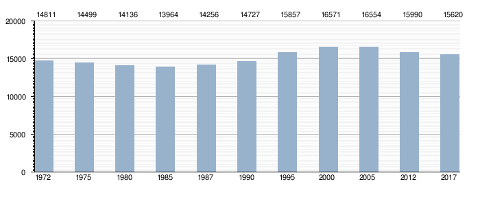
Population development
The following overview shows the population figures of the municipality of Hille according to the respective territorial status. The figures up to 1970 and for 1987 are census results and from 1975 onwards official updates from the State Statistical Office. The figures for 1975, 1980 and 1985 are estimated values, the figures from 1990 onwards are updates based on the results of the 1987 census. Until 1985 the figures refer to the resident population and from 1987 onwards to the population at the place of the main residence.
Hille according to the territorial status at that time
| Year | Inhabitants |
| 1961 (June 6) | 3.755 |
| 1970 (May 27) | 3.815 |
| 1972 (Dec. 31) | 3.767 |
Hille according to the present territorial status
|
|
|


Related articles
Author
AlegsaOnline.com Hille (Minden-Lübbecke), North Rhine-Westphalia, Germany Leandro Alegsa
URL: https://en.alegsaonline.com/art/44211