Hildesheim: Historic city in Lower Saxony, Germany
Hildesheim is a city in Lower Saxony, Germany, on the River Innerste. Known for its medieval cathedral and St. Michael's Church (UNESCO), it combines historic architecture, museums, a university and regional links.
Overview
Hildesheim is a medium-sized city in the state of Lower Saxony, Germany. It serves as the administrative centre of the district of Hildesheim and lies roughly 30 kilometres southeast of Hanover on the banks of the River Innerste. The city has a population of approximately 110,000 and functions as a regional hub for culture, education and light industry.
Image gallery
10 Images


History and development
Hildesheim has medieval origins and grew around a bishopric established in the early Middle Ages. Its ecclesiastical importance is reflected in the large cathedral and monastic foundations that shaped civic life for centuries. Like many German cities, Hildesheim suffered heavy damage during the Second World War; much of the historic centre was rebuilt or restored in the postwar era. In recent decades there has been careful conservation and selective reconstruction of important timber-framed buildings and public spaces.
Notable landmarks
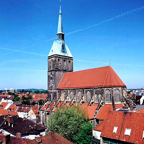
The city is particularly well known for two Romanesque churches that form a recognised cultural ensemble:
- Hildesheim Cathedral (the Dom), with its medieval treasures and monumental bronze doors and columns associated with Bishop Bernward.
- St. Michael's Church, an outstanding example of Ottonian architecture and together with the cathedral listed as a UNESCO World Heritage Site.
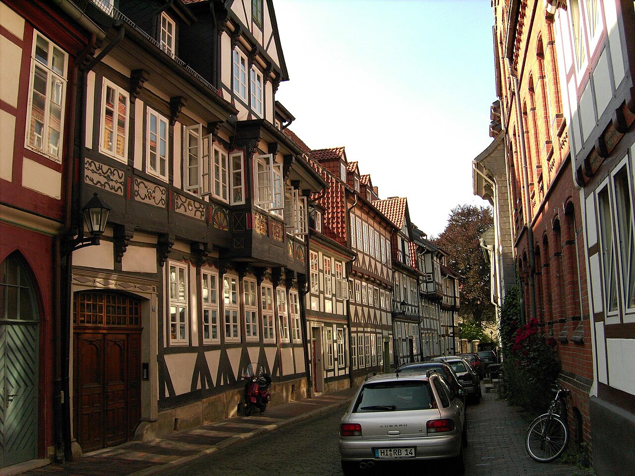
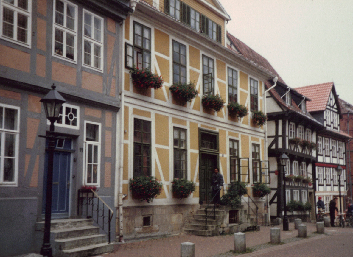
Other points of interest include the historic market square with restored half-timbered houses, several museums such as the Römer- und Pelizaeus-Museum with archaeological and Egyptological collections, and municipal galleries that reflect regional artistic traditions.
Transport and economy
Hildesheim is well connected by road and rail. The nearby Autobahn A7 provides fast north–south access and links to cities including Kassel, Göttingen and Hanover. Regional trains and local bus services connect Hildesheim to surrounding towns. The local economy combines services, education and small-to-medium manufacturing, with an emphasis on regional trade and cultural tourism.
Education, culture and events
The city hosts a university and several higher-education institutions which contribute to research, arts and teacher training. Cultural life includes annual markets, concerts, and exhibitions that draw visitors from the wider Lower Saxony region. Hildesheim's mix of medieval monuments, postwar reconstructions and contemporary cultural institutions makes it a notable example of historical continuity and urban renewal in northern Germany.


Geography
enlarge and show information about the picture
![]()
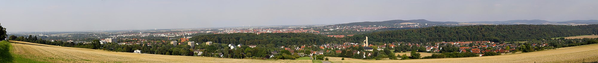
View of the city from the Panoramaweg
Geographical position
Hildesheim lies on the border of the Innerstebergland and the Hildesheimer Börde predominantly on the right bank of the river Innerste, an eastern tributary of the Leine. The city is located north of the Hildesheim Forest and west-northwest of the Vorholz mountain range. The Giesener Berge border the north-western edge of the town.
The city limits of Hildesheim are less than 15 km from Hannover (Bockmerholz) and Salzgitter (Osterlinde) in the north and east and less than 30 km from the city limits of Braunschweig (Ellernbruch). The distances to the nearest large cities in the south and west are in the order of 50-100 km (Göttingen in southern Lower Saxony and Paderborn and Bielefeld in North Rhine-Westphalia).
|
|
|
|
|
|
|
|
|
|
|
|

* Distances are rounded road kilometres to the town centre.
Nature reserves
Seven nature reserves are designated in the urban area of Hildesheim: Am roten Steine, Finkenberg/Lerchenberg, Gallberg, Giesener Teiche, Haseder Busch, Lange Dreisch and Osterberg and Mastberg and Innersteaue.
Neighboring communities
The following municipalities border on the city of Hildesheim. They are named clockwise starting in the north and all belong to the district of Hildesheim: Harsum, Schellerten, Bad Salzdetfurth, Diekholzen, Gronau, Nordstemmen and Giesen.
City breakdown
In the urban area of Hildesheim there are 14 localities according to § 6 of the main statute of the city according to § 90 Abs. 1 NKomVG:
- City centre and new town
- Marienburger Höhe with the Galgenberg
- Moritzberg with the settlements Waldquelle, Godehardikamp and Bockfeld
- Nordstadt with Steuerwald
- Oststadt together with the Stadtfeld
and the former municipalities
- Achtum-Uppen
- Bavenstedt (including the areas east of the A7 belonging to the former urban area)
- Drispenstedt
- Einum
- Himmelsthür (including the areas belonging to the former city area in the area of Sandstraße and the street Am Kupferstrange north of the B 1 and west of the Innerste)
- Itzum-Marienburg
- Neuhof/Hildesheim Forest/Marienrode
- Ochtersum
- Sorsum


History
Early history
North of Hildesheim, on the northern edge of the village of Harsum, one of the oldest rural settlements in northern Germany was discovered. Excavation work began in the summer of 2017, revealing five oldest Linear Pottery house foundations on a 78.5 m high hilltop, which have been dated to around 5700 BC. The houses, measuring up to 30 by 9 m, are oriented northwest-southeast and form a semicircular hamlet-like settlement open to the south.
At the place where the west-east trade route Hellweg (today roughly Bundesstraße 1) crossed the Innerste, there was probably already a settlement and a sanctuary in pre-Frankish times.
Name
An earlier assertion that Hildesheim was called Bennopolis in 577 is not tenable, as the addition in a Paris manuscript is obviously forged. The trade route, the naming after a founder named Hildwin,; also other theses for the origin of the name are mentioned.
The Brockhaus Multimedia 2002 writes: "The name Hildesheim (so since the beginning of the 13th century) is shortened from Hildinisheim (12th century), Hildeneshem (1022) and Hiltenesheim (1004). It contains the old German personal name Hildin or Hildini (to Old High German hiltia, fight)". The spelling Hiltinesheim corresponds to the Old High German, the form Hildeneshem to the Old Saxon form of the name. The original bearer of the name was possibly the oldest settlement in today's urban area, the Old Village, from which the later founded town took the name.
Latin used to be the name Hildesia.
See also: -home
City foundation and early Middle Ages
Excavations carried out directly after the Second World War on the Hildesheim Annen cemetery indicate that in the 8th century there was a missionary or baptistery on the later Hildesheim cathedral hill. A little later the extension of Elze, the Carolingian outpost in the Eastphalian area, took place. Possibly Elze was initially also intended as a bishopric site, since parts of this late 8th century outpost were under the patrocinium of the Apostle Peter. Elze (about 19 km west of today's Hildesheim) was called Aula Caesaris, short Aulica, as a reference to the imperial power. However, the more favourable location of the town probably tipped the scales, so that the bishopric was founded in 815 by Louis the Pious on the territory of present-day Hildesheim. The bishopric was consecrated to the Mother of God Mary (see also foundation legend).
Gunthar and Rembert are regarded as the first bishops of the newly founded diocese. With Ebo, the former archbishop of Reims ascended the Hildesheim bishop's chair in 845. Ebo was caught between the fronts of inner-Franconian conflicts and must certainly have felt his transfer to Hildesheim as pejorative. Nevertheless, it seems probable that the young Hildesheim bishopric profited to a considerable extent from his contacts with the Frankish Reims. Thus a Hildesheim directory of fraternities refers to the church of Rheim as Mater in canonica institutione. Under bishop Altfrid the first cathedral was built. In bishop Bernward's term of office falls the extension of the area of the Domburg, which was now enlarged by the wall built around 1000 and Michaeliskirche built in 1010. Between the cathedral and St. Michael's Church lay the Old Market. The Domburg is still recognisable today in the layout of the Domhof.
High and late Middle Ages
In the course of the development of the city's history, the craftsmen's, merchants' and burghers' town of Hildesheim, which was mainly formed around St. Andreas, became an important community in the centuries after its foundation. In 1167 Hildesheim was an almost completely walled market settlement. In 1217 a town hall was mentioned for the first time.
Directly next to the old town, the episcopal Dammstadt was founded in 1196 and a little later - the first documentary mention dates from 1221 - the dompröpstliche Neustadt. In contrast to the old town, both the Dammstadt and the Neustadt were planned foundations or settlements, the regularity of which can still be seen in the streets compared to the old town. Each of these towns represented a self-contained community and elected its own council. Due to the location of the Dammstadt directly in front of the western gate of Hildesheim, it was perceived as a threat and annoying competition by the larger city. Precisely because of this, the entire town was forcibly put to an end as early as Christmas night 1332: While most of the people of Dammstadt were praying in church, the Hildesheimers invaded the neighboring town, slew priest, laymen, man, woman and child and burned the flourishing town to rubble. This event is closely connected with the double election to the Hildesheim bishop's seat of 1331, which brought about the conflict between Heinrich of Brunswick-Lüneburg, the candidate of the cathedral chapter, and Erich of Schaumburg, the papal candidate. After the city had initially supported Heinrich, most of the council switched to Erich's side in 1332. This change of sides was connected with promises of Erich to the city, which also concerned the dam city. Whether the citizens of Hildesheim or Erich's troops were mainly responsible for the actual raid is disputed in research.
The grown self-confidence of the city was already reflected in the transition from the 13th to the 14th century. In 1298 a town seal with the inscription Sigillum Burgensium de Hildensem (seal of the citizens of Hildesheim) is handed down. In 1300 Hildesheim gave itself its own town charter. This reveals the episcopal impotence and shows that the bishop had de facto lost a large part of his power over the old town. By this time the topographical development of the city was complete. Its boundaries had been marked out and it was essentially fortified. The changing relations between the rightful ruler of the city, the bishop, and his increasingly emancipated subjects, the citizens and their council, continued to be a constant in the city's history until the end of the Middle Ages. After the rebellion of the guilds against the council in 1343, they became involved in the city government in 1345.
Hildesheim also established external contacts, especially with other towns in the immediate vicinity. These connections were supposed to secure the autonomous status of the city on the one hand and to promote regional trade on the other hand. Certainly more limited is the supra-regional networking of the city. Nevertheless, in 1367 representatives of Hildesheim took part in the Cologne city council and thus underlined the participation of Hildesheim merchants in Hanseatic privileges.
16th to 18th century
After centuries of disputes, at the height of which the Old and New Towns at times even faced each other armed, it was not until the end of the 16th century that a union was created with a Samtrath as the superior authority and subsequently at least the inner wall was taken down. After two years of negotiations, the union treaty was signed on August 15, 1583. However, the Old and New Towns were finally united into one city only in 1806 under Prussian rule.
In 1523, as a result of the so-called Hildesheim Collegiate Feud (1519-1523), the Principality of Hildesheim lost large parts of its territories (not regained until 1643) and thus also power in the region. In 1542, the Reformation found its way into the city through Martin Luther's fellow campaigner, Johannes Bugenhagen. "The whole government of the city of Hildesheim" signed the Lutheran Formula of Concord of 1577 in 1580, but the bishopric of Hildesheim continued to exist both as a Catholic diocese and as an imperial principality, and the cathedral as well as the monastery churches (St. Michael only partially) remained Catholic.
During the Thirty Years' War Hildesheim was besieged and occupied several times, so in 1628 and 1632 by imperial, in 1634 by Brunswick-Lüneburg Union troops. Parallel to the economic decline of the city the influence of the Guelphs grew. In 1711 Hildesheim had to accept a Hanoverian garrison. In 1772 the own coinage of the city ended. In 1796/97 the Hildesheim Congress of the North German imperial estates took place in Hildesheim.
19th century
Like all ecclesiastical territories, the Hochstift Hildesheim was secularised in 1803 with the Reichsdeputationshauptschluss and the diocese of Hildesheim was re-described in 1824. Cities and monastery area came temporarily under the rule of the Kingdom of Prussia. Only now the old and the new town were united to one town. Even before the initiated reforms were finished, with the Peace of Tilsit in 1807 the now secular prince-bishopric Hildesheim came under the Kingdom of Westphalia. In the department of the Oker, the city was the seat of the sub-prefecture of the district of Hildesheim. After the Battle of Leipzig in 1813 with the defeat of Napoleon Bonaparte, the district of Hildesheim was assigned to the Kingdom of Hanover and in 1815 became the seat of an office, which from 1823 belonged to the newly formed Landdrostei Hildesheim. However, the city itself enjoyed a certain independence in it from the beginning. The Amt Hildesheim was changed several times, among other things in 1852 some municipalities were added to the neighbouring Amt Marienburg, whose seat was also in Hildesheim. In 1859, 16 municipalities of the dissolved Amt Ruthe were assigned to the Amt Hildesheim.
After the German War in 1866, the Kingdom of Hanover became the Province of Hanover in the Kingdom of Prussia and Hildesheim was once again a Prussian city. There was a rapid economic upswing; the half-timbered buildings in the city centre were largely replaced by new buildings.
The Hildesheim silver find of 1868 (today exhibited in the Collection of Classical Antiquities of the National Museums in Berlin) is one of the most important archaeological discoveries on German soil. Some historians even regard it as a reference to the Varus Battle (9 AD).
The fourth great cholera pandemic (1863-1876) struck the city in 1867. In 1869, the former monastery church of St. Paul was converted into the municipal festival hall. In 1885, Hildesheim received the status of a district-free city and became the seat of the district of Hildesheim, which emerged from the Hildesheim office, as well as the administrative district of Hildesheim, which emerged from the Hildesheim district administration.
1900 till 1945
At the beginning of the century the connection to the railway network was improved and from summer 1905 an electric tram was running. Europe's first fully automatic electromechanical local exchange was put into operation at Hildesheim Domhof by the Deutsche Reichspost on 10 July 1908. The self-dialing equipment with lifting rotary dials according to the patent of Almon Strowger was initially designed for 900 connections.
In 1925 the Hafenbetriebsgesellschaft Hildesheim was founded and in 1928 the Stichkanal Hildesheim and the Hafen Hildesheim were put into operation.
The Robert Bosch GmbH plant was built in the Hildesheim Forest in Neuhof. Created under the camouflage name ELFI (Elektro- und Feinmechanische Industrie GmbH), the company manufactured starters, alternators, magnetos, and inertia starters for large truck and tank engines of the Wehrmacht under the direction of Bosch (see also Neuhof - ELFI-Werk). From the end of 1942 until April 1952, the company operated under the name Trillke-Werke GmbH. During the Second World War, the Küstrin plant of the Bosch subsidiary Blaupunkt, which had been endangered by the Battle of East Pomerania, was transferred to Trillke at the beginning of 1945. After the end of the war, Trillke initially began repairing radio sets. Trillke-Werke or Bosch/Blaupunkt, which remained undestroyed during the war, was an important supplier to the automobile industry during the economic miracle of the 1950s.
The air raids on Hildesheim in 1944/45 destroyed large parts of the city. Bombers almost completely destroyed the old town of Hildesheim on 22 March 1945. Only 200 of the 1500 half-timbered houses remained. 90 percent of the historic old town was destroyed in the firestorm.
In Hildesheim, shortly before the liberation of the city by the US Army, final phase crimes took place in which 209 people were murdered by the Hildesheim Gestapo.
On April 7, 1945, troops of the 9th US Army occupied Hildesheim.
Post-war period until 1990
In 1948 the reconstruction of the town began. The historic market with the Knochenhaueramtshaus was rebuilt from 1984 to 1989. The destroyed half-timbered house on Andreasplatz, called Umgestülpter Zuckerhut, was rebuilt in 2009/10, 500 years after its construction.
Germany's first Christmas post office was set up in the post office of the Himmelsthür district of Hildesheim in 1967. Thousands of children still write letters "to Santa Claus in Himmelsthür, 31137 Hildesheim" every year and receive a reply after a few days. Christmas special stamps cancelled with the Himmelsthür Christmas postmark are collector's items for philatelists worldwide. Regardless of its worldwide fame and despite considerable protests by local politicians and district residents, the Himmelsthür post office ("the heavenly post office") was closed by Deutsche Post AG. However, children's letters to the Himmelsthür Santa Claus are still answered.
In 1970 Hildesheim became a university town when the Hildesheim department of the University of Education of Lower Saxony and in 1971 the Hildesheim University of Applied Sciences (Königliche Baugewerkschule Hildesheim von 1900) started their operations in Hildesheim. Incorporations in the 1970s led to an increase in the number of inhabitants; in 1974 there were 100,000 inhabitants.
In the context of the district reform 1974 Lower Saxony the so far independent city Hildesheim and the administrative district Hildesheim-Marienburg were united on 1 March 1974 to the administrative district Hildesheim, which was enlarged on 1 August 1977 by the former administrative district Alfeld (Leine). On 1 February 1978 the administrative district of Hildesheim was dissolved.
After 1990
Until the dissolution of the district governments in Lower Saxony at the end of 2004, the district of Hildesheim belonged to the administrative district of Hanover. In 2005 Hildesheim received the silver award in the municipal flower decoration competition "Unsere Stadt blüht auf".
Until 2014, DB Fernverkehr operated a terminal in Hildesheim for loading vehicles onto motorail trains.
In 2015, the city and diocese of Hildesheim celebrated its 1200th anniversary and, as part of this, held the Day of Lower Saxony from 26 to 28 June.
Military
Hildesheim was garrison for the 3rd Hanoverian Infantry Regiment 79 of the Prussian Army until 1919.
Since June 1926 Hildesheim had a small commercial airfield. Today's Hildesheim airfield was developed into an air base from 1933 and was a reconnaissance flying school of the Luftwaffe of the Wehrmacht until 1939 and from 1934 to 1944 also the seat of the Luftwaffe's flying training school. Further units were transferred to Hildesheim during the Second World War, including the IV. Gruppe of Kampfgeschwader 51 "Edelweiß", II./Zerstörergeschwader 26 and I. Gruppe of Kampfgeschwader 200 and paratrooper units.
The barracks of the city were first used by the British forces and from April 1962 also by the Bundeswehr with the Army Air Corps Squadron 1 (until 1979) again. In 1979 the British Army used the site of the withdrawn Bundeswehr Army Air Corps and stationed there the 1st Regiment of the Army Air Corps with anti-tank helicopters. Adjacent, the German Army stationed the Medical Battalion 1 (later Sanitätsregiment 1) in the Oberstabsarzt-Dr.-Julius-Schoeps-Kaserne.
British soldiers left Hildesheim on 1 October 1993. Most recently, the 1st Royal Tank Regiment and the 1st RGT Army Air Corps were stationed in Hildesheim. Until December 2007, the city was the headquarters of the German Army's Panzergrenadier Brigade 1 in the Mackensen Barracks, which belonged to the 1st Armoured Division in Hanover. In Ledebur Barracks, the Army maintained a force training center, formerly Panzergrenadier Battalion 11, Panzerjäger Company 10 and other brigade units. Gallwitz Barracks housed Panzer Battalion 14 until its disbandment in 1992. In 1992, Medical Battalion 1 was moved from the airfield area to Gallwitz Barracks, which was simultaneously renamed Oberstabsarzt-Dr.-Julius-Schoeps-Kaserne. The town was home to a Kreiswehrersatzamt (KWEA) in the Waterloo barracks. In the course of the transformation of the armed forces of the German Federal Armed Forces, the Panzergrenadierbrigade 1 and the Kraftfahrausbildungszentrum Hildesheim were disbanded as of December 2007 with 410 service posts at last count.
Other military installations of the Bundeswehr in Hildesheim were the Osterberg
site training area near Himmelsthür, the Emmerke site ammunition depot and the Giesen site firing range. These properties were abandoned. The Emmerke ammunition depot has been renaturalised since August 2007 and the guard and functional buildings have been demolished. The Ledebur barracks were demolished and the Helios Klinikum Hildesheim was built here.
Incorporations
The following municipalities and parishes were incorporated into Hildesheim:
- 1911: Moritzberg
- 1912: Steuerwald
- 1938: Drispenstedt and Neuhof
- 1971, February 1: Ochtersum
- 1974, 1 March: Achtum-Uppen, Bavenstedt, Einum, Himmelsthür, Itzum, Marienburg, Marienrode and Sorsum
Population development
While the population of Hildesheim grew only slowly in the Middle Ages and at the beginning of modern times due to numerous wars, epidemics and famines, the number of inhabitants increased rapidly with industrialization in the 19th century. In 1803 there were 11,000 inhabitants, around 1900 around 43,000 and in May 1939 there were 72,495 inhabitants. By May 1, 1945, the number had dropped to 39,492 and by 1950 the number had returned to pre-war levels.
On 1 March 1974, the population exceeded 100,000 due to territorial reform and incorporations, and reached its historic high of 107,629 people. Until the beginning of the 2000s, this number was constant at approx. Just under 100,000 inhabitants in the 2011 EU census. Since 31 December 2015, the population has been constant at over 100,000 inhabitants.
The following overview shows the population figures according to the respective territorial status. Up to 1833, these are mostly estimates, thereafter census results (¹) or official updates of the respective statistical offices or the city administration itself. From 1843 onwards, the data refer to the resident population, from 1925 onwards to the resident population, and since 1987 to the population at the place of principal residence. Before 1843, the number of inhabitants was determined according to non-uniform survey methods.
|
|
|
|
¹ Census result
() Current figures from the population register in parentheses.
According to data from the 2011 European Union Census, the proportions are as follows (rounded): 16% of Hildesheim's population is under the age of 18, 17% is aged 18 to 29, 26% is in the 30 to 49 age bracket, 19% is aged 50 to 64, and 22% is 65 and older. Women are in the majority with 53 %.
23 % of the inhabitants have a migration background. 92 % of the inhabitants have German citizenship.


Questions and answers
Q: Where is Hildesheim located?
A: Hildesheim is located in Lower Saxony, Germany.
Q: In which district of Germany is Hildesheim situated?
A: Hildesheim is situated in the district of Hildesheim.
Q: How far is Hildesheim from Hanover?
A: Hildesheim is about 30 km southeast of Hanover.
Q: What is the name of the river that flows through Hildesheim?
A: The river that flows through Hildesheim is called River Innerste.
Q: What is the size of Hildesheim in terms of population?
A: Hildesheim has a population of about 110,000 people.
Q: How can Hildesheim be accessed by road?
A: Hildesheim can be accessed from Autobahn A7, which links Kassel, Göttingen, and Hanover.
Q: Does River Innerste flow into River Leine?
A: Yes, River Innerste is a smaller river that flows into River Leine.
Related articles
Author
AlegsaOnline.com Hildesheim: Historic city in Lower Saxony, Germany Leandro Alegsa
URL: https://en.alegsaonline.com/art/44197
Sources
- www1.nls.niedersachsen.de : "Alle politisch selbständigen Gemeinden mit ausgewählten Merkmalen am 31.12.2018 (4. Quartal)" · web.archive.org
- destatis.de : destatis.de/DE/ZahlenFakten/LaenderRegionen/Regionales/Gemeindeverzeichnis/Administrativ/…
- www1.nls.niedersachsen.de : Landesbetrieb für Statistik und Kommunikationstechnologie Niedersachsen, 102 Bevölkerung - Basis Zensus 2011, Stand 31. Dezember 2015 (Tabelle K1020014)