
High Plains (United States)
The High Plains are the elevated western sector of the Great Plains, spanning several states; a semi‑arid grassland shaped by tectonics, cold winters, strong winds, sparse population and extensive agriculture.
The High Plains form the elevated western margin of the central North American grassland often called the Great Plains. They lie immediately east of the Rocky Mountains, rising in elevation from roughly 1,160 feet (about 350 m) at the eastern edge to more than 7,800 feet (about 2,400 m) near the mountains. The region is defined more by its broad high plateau and rolling plains than by sharp relief: wide horizons, long views and a landscape dominated historically by native mixed and shortgrass prairie.
Image gallery
10 Images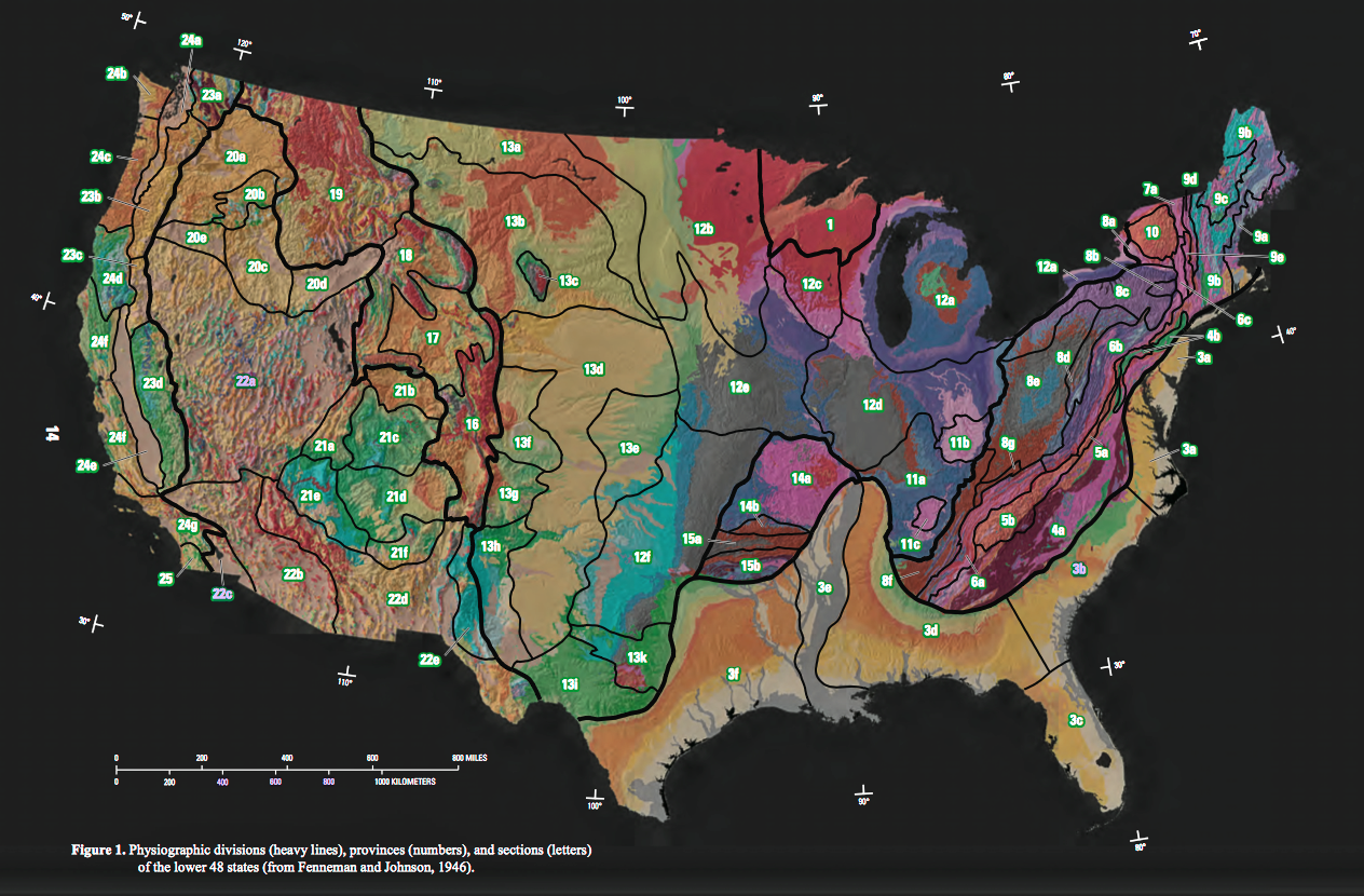





Location and political boundaries
The High Plains cross multiple state lines in the central United States. Major portions occur in southeastern Wyoming, southwestern South Dakota, western Nebraska, eastern Colorado, western Kansas, eastern New Mexico, western Oklahoma, and the southern fringe of the Texas Panhandle. Geographically the area is often treated as part of the Western United States but significant tracts lie within states that are often considered part of the Midwest. Political and economic patterns vary widely from county to county, but the broad landform ties these places together.
Geology and formation
Geologically the High Plains are a product of long‑term continental processes. As described by studies of regional geology, the plateau owes its uplift and thickness to the westward motion of the North American plate and attendant tectonic interactions with other landmasses such as Eurasia during the Mesozoic and Cenozoic eras. Material at the western margin was forced up while older sediments accumulated and were stretched across the interior. Episodes of compression and the subduction of oceanic crust beneath continental margins, together with movement of multiple lithospheric plates, helped build the adjacent mountain ranges and influenced the broad tilt and thickness of the plains. These same forces account for why the western states display more prominent mountainous terrain than areas farther east.
Climate and weather extremes
The climate of the High Plains is typically cold semi‑arid (Köppen classification BSk) with total annual precipitation commonly between 10 and 20 inches (250–510 mm). Low atmospheric moisture (moisture) and the region's high elevation produce strong diurnal temperature swings and large seasonal contrasts. Typical day–night ranges of 30 °F (≈17 °C) are common, and exceptional 24‑hour shifts of 100 °F (≈56 °C) have been recorded in the broader northern plains. The town of Browning, Montana, for example, experienced a dramatic fall in temperature in January 1916 that is often cited among extreme 24‑hour changes. Persistent westerly winds and sudden frontal passages increase wind chill effects (wind chill) in winter and contribute to dust events at times.
Ecology, water and land use
Originally dominated by mixed and shortgrass prairie communities, the High Plains supported large herds of bison and a diversity of grassland wildlife. Much of the natural cover has been converted to cropland and pasture, particularly where irrigation is available. The region overlies major groundwater reserves — including the Ogallala Aquifer, widely used for irrigation — and water availability now largely determines agricultural intensity, crop choice and long‑term sustainability. In many places, groundwater levels have declined due to pumping, prompting conservation and efficiency measures.
Economy, energy and settlement
Economic activity on the High Plains centers on dryland and irrigated agriculture (cereals, sorghum, cotton in some southern areas, and cattle ranching), with increasing contributions from energy production. Strong, steady winds have made parts of the plateau attractive for wind power development; modern wind farms are a growing source of local revenue and electricity. Despite these industries, the High Plains exhibit low population density: states such as Wyoming are among the least populated, with Wyoming often cited as having the second lowest population density in the United States after Alaska. Small towns, agriculture service centers and military installations punctuate a broadly rural landscape.
Key facts and distinctions
- Elevation rises from roughly 350 m to over 2,400 m across the region, shaping climate and vegetation.
- Classified largely as cold semi‑arid (Köppen BSk), with annual precipitation usually 250–510 mm.
- Stronger winds and greater temperature variability than many adjacent lowland regions; wind chill can be severe (wind chill).
- Crosses multiple states including Wyoming, Nebraska, Colorado and Kansas, and touches New Mexico and Oklahoma.
- Geological history tied to continental plate motions and subduction processes that also influenced nearby Rocky Mountains (geology, tectonics).
- Important contemporary issues include groundwater management, sustainable agriculture and renewable energy development such as wind farms.
Because the High Plains form a transition between the lowland interior and the rising Cordillera to the west, they are a distinctive physical and cultural landscape. Their combination of elevation, semi‑arid climate and open grassland has shaped regional economies and settlement patterns for more than a century, and will continue to influence land‑use choices in coming decades.
Questions and answers
Q: What is the High Plains?
A: The High Plains is a subregion of the Great Plains. It is located in southeastern Wyoming, southwestern South Dakota, western Nebraska, eastern Colorado, western Kansas, eastern New Mexico, western Oklahoma and south of the Texas Panhandle.
Q: What causes the geography of the High Plains?
A: The high plains are caused by the same process as caused the Rockies. This process is due to North America moving west away from Eurasia over 100 million years ago which has resulted in plates being subducted under its western side and stretching out its eastern side.
Q: What type of climate does the High Plains have?
A: The High Plains has a "cold semi-arid" climate—Köppen BSk—with an average annual precipitation between 10–20 inches (250–510 mm).
Q: How extreme can temperatures be in this region?
A: Temperatures can range from day to night by 30 °F (17 °C) and 24-hour temperature shifts of 100 °F (56 °C) are possible. In Browning, Montana from January 23, 1916 to January 24, 1916, there was a world record for greatest temperature change in 24 hours with a drop from 44 to −56 °F (7 to −49 °C).
Q: What are some other features associated with this region?
A: The region is known for steady and sometimes intense winds that come from the west which adds wind chill factor during winter months. Additionally it has one of lowest population densities in continental United States with Wyoming having second lowest population density after Alaska.
Q: How has economic development been impacted by this area?
A: One of latest areas of economic development for this region has been development of wind farms.
Related articles
Author
AlegsaOnline.com High Plains (United States) Leandro Alegsa
URL: https://en.alegsaonline.com/art/44109
Sources
- ne.water.usgs.gov : "USGS High Plains Aquifer WLMS"
- tapestry.usgs.gov : "Physiographic Regions"
- wrh.noaa.gov : "Top Ten Montana Weather Events of the 20th Century"