Herford — town in North Rhine-Westphalia, Germany
Herford is a historic town in eastern Westphalia, Germany, founded in 789. It is the administrative centre of the Herford district, with about 67,000 inhabitants and notable cultural and medieval sites.
Overview
Herford is a mid-sized German town in the state of Germany, located in eastern Westphalia within the state of North Rhine-Westphalia. Traditionally traced to a foundation in 789, the town grew from a religious foundation into an administrative and market centre. Today it serves as the seat of the district of Herford and has a population of about 67,000 inhabitants.
Image gallery
9 Images


History and origins
The town's origin is medieval: it began around a religious foundation and later developed commercial ties typical for settlements in Westphalia. Over centuries Herford shifted between ecclesiastical, princely and modern civic governance. Its long history is reflected in surviving church buildings and in the layout of its old town.
Characteristics and landmarks
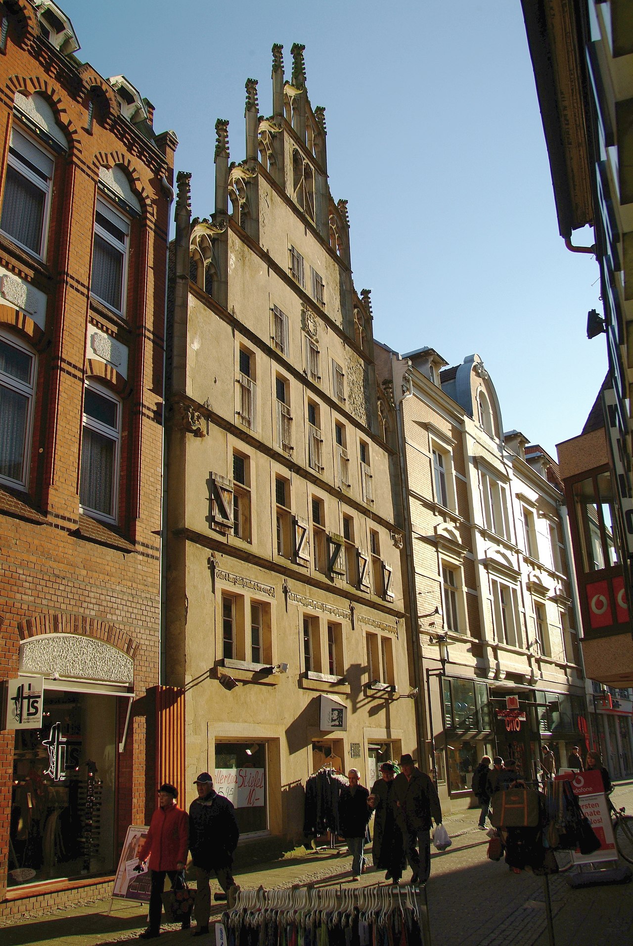
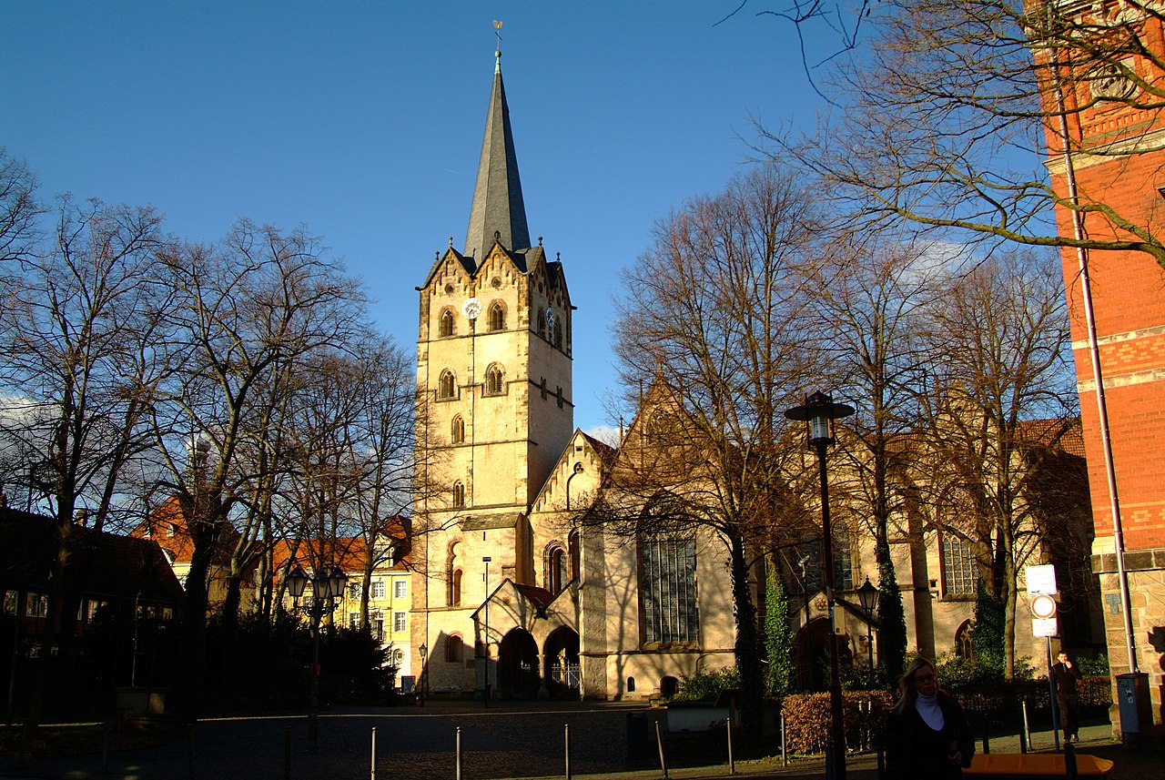
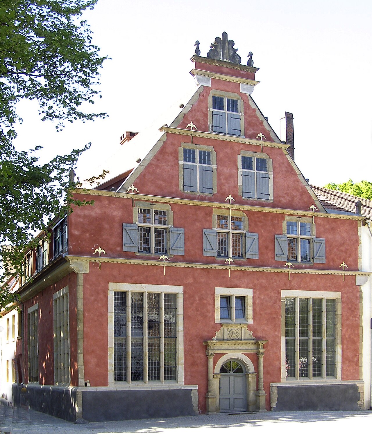
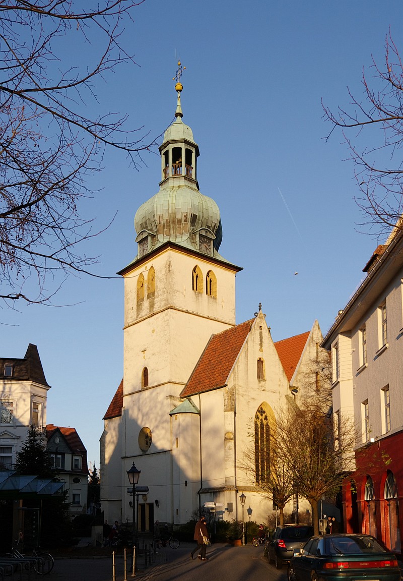
Herford lies along the Werre river and combines historical architecture with contemporary cultural institutions. Notable sites include the former monastic and church ensemble in the old town and a museum known for contemporary art and design. Public squares, pedestrian streets and preserved civic structures convey the town's layered past.
Economy and transport
Its economy has roots in regional manufacturing and trade; today the mix includes services, small and medium industry and cultural tourism. Herford is connected to the regional rail and road network, linking it to larger cities in the Ruhr and eastern Westphalia.
Notable facts
- Foundation traditionally dated to 789, giving the town a long medieval lineage.
- Administrative centre of the district of Herford.
- Combines historic buildings with contemporary cultural offerings.


Geography
Geographical location
The district town of Herford is located in the north-eastern part of North Rhine-Westphalia in Ostwestfalen-Lippe, which is congruent with the administrative district of Detmold.
Geographically, Herford belongs to the Ravensberg Hills and lies between the Teutoburg Forest and the Wiehen Mountains. The eastern elevations of the city such as the Stuckenberg with the city forest already belong to the Lipper Bergland. The highest elevation is the Dornberg (240 m) in the district Schwarzenmoor. The lowest point (56 m) is in the Werre valley in the district of Falkendiek. The Ravensberger Hügelland is slightly undulating with numerous small sinks and is used intensively for agriculture. The landscape is sparsely wooded only at high altitudes.
The town is located at the mouth of the Aa into the Werre, which is north of the town centre. The Werre flows through the town from Bad Salzuflen to the mouth of the Aa in a southeast-northwest direction. From there it runs north, largely forming the city boundary with the municipality of Hiddenhausen. The Aa comes from the direction of Bielefeld, where it receives its name only shortly before the Herford city limits at the confluence of the Lutter and the Johannisbach. The Aa is the border river between the Herford districts of Elverdissen, which lies to the east of the Aa, and Stedefreund and Diebrock. Towards the north it separates the Altstädter Feldmark from the Radewiger Feldmark, the Altstadt from the Radewig and the Herforder Neustadt from the Radewiger Feldmark. The Werre forms the border between the Neustädter Feldmark east of the river and the Altstädter Feldmark, the Neustadt and the Radewiger Feldmark west of the Werre.
Herford is located 15 kilometres north-east of Bielefeld and 46 kilometres east of Osnabrück. Dortmund and Hanover can be reached via the federal motorway 2 and the railway line Hamm-Minden, which are about 100 kilometres away from Herford. Along this axis stretches the East Westphalian conurbation, which runs from Gütersloh via Bielefeld and Herford to Minden.
Since the loss of the Kreisfreiheit it belongs since 1 January 1969 again as the largest city to the district Herford.
City breakdown
Since 1969, the city has consisted of the following neighborhoods (population as of December 31, 2015):
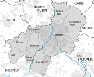
| District | Area | Inhabitants |
| Herford city | 25,07 km² | 51.798 |
| Diebrock | 7,04 km² | 2024 |
| Eickum | 7,39 km² | 1767 |
| Elverdissen | 9,31 km² | 4158 |
| Falkendiek | 6,57 km² | 861 |
| Herringhausen | 2,16 km² | 2736 |
| Laar | 4,80 km² | 467 |
| Schwarzenmoor | 14,74 km² | 1632 |
| Stedefreund | 1,78 km² | 1462 |
Herford city means the core city as it existed until 31 December 1968. It consists of the inner city and the Feldmarken, which are not districts in their own right.
The city centre is the historical centre of the city, located within the ramparts. It includes the former abbey district ("die Freiheit"), the oldest quarter Radewig, the Old Town and the New Town. The Old Town and Radewig were jointly administered by a town hall on the Old Market Square, while the New Town was independent and had its own town hall. The three quarters did not merge into one town until 1634.
For each district there is a Feldmark, which stretches from the city centre to the former city boundary: the Altstädter Feldmark (in the southeast), the Neustädter Feldmark (in the northeast) and the Radewiger Feldmark (in the west). Within the Neustädter Feldmark are the areas Stiftberg, Friedenstal and Waldfrieden (with the zoo) and Nordstadt, but these are not precisely delimited.
The largest of the districts incorporated on 1 January 1969 is Schwarzenmoor, the smallest is Stedefreund. Within the districts there are the areas or quarters Dickenbrock (in Herringhausen), Hausheide and Hollinde (in Diebrock), Nieder-Eickum, Ober-Eickum, Pottkamp and Kaishagen (in Eickum), Elsen, Herforder Heide and Hillewalsen respectively Hillewalser Baum (in Elverdissen) as well as the mountains Dornberg, Hamscheberg and Stuckenberg (in Schwarzenmoor) and Homberg (in Falkendiek).
Extent and use of the urban area
The total area of the city of Herford is 78.95 km². The largest extension in north-south direction is about 13.1 kilometers and in east-west direction about 13.8 kilometers. The city boundary has a length of 56 kilometres. The inner city within the ramparts (Old Town, New Town, Radewig) has an area of 58 ha (0.58 km²). The length of the ramparts is 3.1 kilometers.
| Land use of the city of Herford | |||||||
|
| Agricultural land | Forest area | Building, | Traffic area | Water surface | Sports and green area | otheruse |
| Area in km² | 41,16 | 7,53 | 20,20 | 7,28 | 0,81 | 1,86 | 3,0 |
| Percentage of total area | 52,00 % | 9,5 % | 25,5 % | 9,2 % | 1,0 % | 2,4 % | 0 % |
Neighboring communities
Herford borders the cities of Enger and Hiddenhausen to the west, Löhne to the north, Vlotho to the northeast (all district of Herford), Bad Salzuflen (district of Lippe) to the southeast and the city of Bielefeld to the southwest.
Geology
From the east, as an offshoot of the Lippisches Bergland, the Herforder Keupervorsprung pushes north past the town in the course of the Piesberg-Pyrmont axis. The Keuper promontory, which becomes increasingly flatter towards the west, is cut through by the Werre valley, 55 metres above sea level, between the 201-metre-high Homberg and the 168-metre-high Schweichelner Berg. About three kilometres south of the Keuper promontory the Aa flows into the Werre coming from Lippe. Due to the structuring effect of its river valleys, two further elevated areas approach Herford between them: one from the south, from the Teutoburg Forest, the other from the west, from the Jöllenbeck Plateau.
To the south of the Keuper promontory is the 100 to 200 metre high, 10 km wide Herford Lias syncline with clay and clay marlstone. The landscape was structured in the Pliocene and Old Pleistocene by wide valleys to its present form. During the Ice Age, the area was covered with a fertile clay or loess loam blanket, which is preserved in a thickness of four to six metres. The city of Herford is located in this area. During the Vistula Ice Age, the ice sheet did not reach this area. Due to the water damming effect it produced sandy fill terraces of two to five metres in height in the larger valleys.
Herford is moderately suitable in some locations in the western part of the city, very suitable in some locations especially in the north-eastern part of the city and otherwise well suited for the use of geothermal heat sources by means of geothermal probes and heat recovery by heat pump heating systems.
Climate
Climate data
Herford lies in the area of the sub-Atlantic maritime climate and shows partially very weak continental influences. The maritime climate of the Atlantic climate range is characterised by relatively evenly distributed and regular precipitation and relatively mild, relatively balanced temperatures throughout the year. Under the Atlantic influence, winters are usually mild and summers moderately warm. Under this influence, the temperature tends to be colder in winter, warmer in summer, and precipitation tends to be lower than under the influence of the predominantly maritime climate.
Due to the basin location of the city of Herford in the Ravensberg hills, spring arrives up to two weeks earlier than in the surrounding low mountain ranges. The prevailing south-westerly wind direction brings regular precipitation from the Atlantic, but the amount of precipitation is lower in Herford than in the Teutoburg Forest due to the basin location, where uphill rains fall more often.
| Monthly average temperatures, precipitation and sunshine duration for Herford (1981-2010)
Source: DWD | |||||||||||||||||||||||||||||||||||||||||||||||||||||||||||||||||||||||||||||||||||||||||||||||||||||||||||||||||||||||||||||||||||||||||||||||||||||||||||||||||||||
See also: Climate in East Westphalia-Lippe
Weather station
There has been a weather station in Herford since 19 July 1891. It was initially located on the grounds of the school Mindener Straße at the corner of Ortsieker Weg and was operated by the then teacher and later principal Heinrich Wulff until his death in 1927, then by his family on their own property. The data were measured three times a day and initially transmitted to the Royal Prussian Meteorological Institute in Berlin, and after the Second World War to the German Weather Service, which gave up the weather station on 31 December 2007. One reason for the abandonment was the progressing building development in the area Ortsieker Weg, which influenced the measurement results for the temperature upwards. Since then, the Wulff family has been recording the precipitation for the North Rhine-Westphalia State Office for Nature, Environment and Consumer Protection. The temperatures continue to be measured out of personal interest. Over time, the mean annual temperature has tended to get higher and higher. By the end of the 1990s, it had moved out of the single digits and into the double digits. Whether climate change is responsible for this or the progressive building and sealing of the land around the station cannot be determined. The area observed is too small for this.
Another weather station in Herford can be found at wetter.com.


History
→ Main article: History of the city of Herford
City foundation
Already since the Neolithic Age, the confluence of the rivers Aa and Werre attracted people as a place of settlement. In the later town area, several farms can be traced since the Saxon period in the early Middle Ages.
Situated in a favourable, economically and militarily not unimportant traffic situation, Herford developed from 789 (foundation legend in the Vita Waltgeri) on the territory of three older farms (Adonhusa, Herifurth and Libbere). Around 800 the important women's monastery of Herford was founded, whose significance extended far beyond the region. In 823 Emperor Ludwig the Pious placed the monastery under his personal protection. The emperor transferred further estates to the abbey, which now remained closely connected to the Corvey monastery. Soon after, a merchant settlement also developed. It is assumed that in 833 Ludwig the Pious granted the monastery of Herford market, minting and customs rights.
Especially the Ottonians were closely connected to Herford: Mathilde, the wife of Henry I. In 926, the monastery was destroyed during the Hungarian invasion and subsequently rebuilt with royal support. Otto the Great confirmed the market and customs rights in 973, making Herford one of the oldest markets in Germany. In 1011, based on an apparition of the Virgin Mary (Herford Vision), Abbess Godesdiu founded the monastery on the mountain outside the city gates as an educational institution for the daughters of the lower nobility, which developed into a place of pilgrimage.
From 1988 onwards, valuable finds from the Carolingian, Ottonian and later periods were discovered during excavations in the remains of the abbey buildings.
12th to 15th century
Herford was an important spiritual and intellectual centre in the Middle Ages and one of the best fortified German towns with five town gates and 14 towers assigned to the various guilds. They were part of the 3.5-kilometre-long walled city fortifications, which were surrounded by the Werre, the Aa and the town moat. The Bowerre, which is now filled in, represented the original course of the Werre, while today's course of the Werre between Bergertor and the mouth of the Aa as a canal was originally part of the city fortifications.
In the Hohenstaufen period, Herford Abbey was confirmed as an imperial monastery (1147, Frederick Barbarossa 1152); later emperors confirmed various rights of the abbey and the imperial city of Herford. The abbess was an imperial princess with quasi-bishop's rights ("Monstrum Westphaliae").
Around 1170, a burgher community was formed and the city law was developed, whereby the Dortmund city law served as a model. Around 1220, the earliest mention of the Herford town council can be proven; it was thus one of the first in Germany. In 1224 the new town of Herford was founded. The condominium, the joint independent government of abbey and town, exercised imperial town law from the middle of the 13th century onwards; in return, the mayor and council took an oath of fealty to the abbey. Various Roman-German kings and emperors from the house of the Ottonians and the Hohenstaufen dynasty visited the city, as did later Emperor Charles IV in 1377.
Herford was a member of the Ladbergener Städtebund, other city alliances and was very active in the Hanseatic League from 1342 until the 17th century. In the safety of the city, almost all monastic orders of the time founded spiritual branches, so that the city was called Sancta Herfordia. The lively commercial activity extended early over the whole Hanseatic area, but also the connections to the west (Flanders) were significant. The production and trade of cloth was particularly important in the 13th century. Numerous guilds and guilds are mentioned in the Herford law book around 1375.
Until 1634 the new town remained independent next to the old town with its own mayor. The outer boundaries (Landwehr borders) of the medieval city of Herford remained the city limits until 1969. At the arterial roads, the beaumers opened the turnpikes for those who wanted to enter or leave the town. Still today the farms Vlothoer Baum (direction Vlotho), Ufler Baum (direction Bad Salzuflen), Ahmser Baum (direction Ahmsen), Lockhauser Baum (direction Lockhausen), Hillewalser Baum (direction Elverdissen), Niederbaum (direction Bielefeld), Strothbaum (direction Enger), Düsedieksbaum (direction Bünde) and Eimterbaum (direction Löhne) stand at these places. Only the Neue Baum in the direction of Minden no longer exists.
Modern Times
In the early modern period, a long legal dispute began over the city's status as an imperial city. The abbey was free of the empire with abbesses as imperial princesses, who were mostly noble ladies of Brandenburg-Prussian families. The city of Herford exercised imperial city rights due to the so-called condominium of abbey and city. Several lawsuits before the Imperial Chamber Court, initially brought by the Empire, which was keen to levy imperial taxes on Herford, finally led to its confirmation as an imperial city in 1631, which was in the city's interest.
The Reformation was already established in the town around 1530, the abbey remained Catholic until 1565. The town was besieged several times during the Thirty Years' War, and in 1638 large parts of the town burned down.
As a result of the Jülich-Klev succession disputes, Herford was occupied by Brandenburg troops in 1647 and lost its independence. The transfer to Brandenburg in the Peace of Westphalia was finally confirmed in 1652. Herford was annexed to the county of Ravensberg and thus became a Brandenburg-Prussian county town. Administratively, the county of Ravensberg was merged with the principality of Minden in 1722. When the city wall was no longer needed in 1765, the material was auctioned off. In 1803 the monastery of Herford was secularised and added to the county of Ravensberg.
After the heavy defeat of Prussia against Napoleon in 1806, the area was incorporated into the newly founded Kingdom of Westphalia in 1807 as the Canton of Herford of the Department of the Weser. The next territorial change occurred for the Herford area in 1811, when large parts of northwest Germany were annexed to the Empire of France, with the border to the Kingdom of Westphalia in this area running along the Werre River. The city of Herford belonged to the Westphalian department of the Fulda until 1813.
In 1816 Herford became the county seat of the district of Herford within the Prussian province of Westphalia and together with it became part of the newly founded state of North Rhine-Westphalia in 1946. From 1911 to 1969 Herford was an independent city, but remained the seat of the district administration of the county of Herford.
In 1847 Herford received a railway connection with the construction of the Cöln-Minden railway. In 1880 the line to Detmold and Altenbeken (Lippische Bahn) and in 1904 the line to Kirchlengern were built. In 1902, the old reception building was replaced by a new building and rebuilt several times in the meantime. From 1911 onwards, the two freight train tracks between Hamm and Minden were built, which went into operation between 1912 and 1916, so that the line has been four-tracked since then. In this context, the railway line, which had been at ground level until then, was put on an embankment and the level crossings were replaced by bridges. New freight and sidings were also added, for which the old freight depot had to be demolished. It was rebuilt further west in 1918 at its present location. Electrification of the Cologne-Minden main line was completed with the first run on September 29, 1968. This was followed on 27 May 1975 by the line to Altenbeken and on 20 September 1976 by the connection to Kirchlengern, which leads to Bünde.
In August 1900 the Herforder Kleinbahn to Enger was opened and in September the extension to Spenge and Wallenbrück followed. In 1902 a line via Bad Salzuflen and Exter to Vlotho was added. The narrow-gauge railway (metre gauge) was electrified in the 1930s. Operations were discontinued in 1962 on the Herford-Vlotho line, and in 1966 on the Herford-Spenge line.
Favoured by the railway lines, the period of high industrialisation began very early in Herford with the settlement of numerous factories, in which in particular textiles, linen and outerwear were produced.
After the Renaissance-style town hall on the Old Market Square was demolished in 1878, the new neo-Baroque town hall was built on the site of the former abbey from 1914 to 1917 during the First World War. At the same time, the new market hall was built opposite in the same architectural style, as the Old Market was no longer sufficient for the market stalls.
During the First World War, parts of the German Army were stationed in the city, for whom mass quarters were set up in schools, factories, restaurants and the city theatre. At times up to 2400 soldiers were housed in the city. Lazarets were set up in orphanages, the Schützenhof and hospitals. After barracks were built in three areas of the town in the 1930s, Herford became a garrison town from 1935.
To relieve the Old Cemetery in the city centre, which had existed since around 1800, the Ewiger Frieden Cemetery was established in the north of the city in 1924, which is still the largest cemetery in Herford today. In 1955 the spacious chapel was built.
During the Second World War, the city suffered comparatively little destruction from air raids. Just under 40 percent of the houses were slightly damaged, seven percent showed medium to heavy damage and only about six percent were totally destroyed. After the war, some of the historic buildings fell victim to simplistic urban planning. Thus, the entire quarter around the Bergertor wall gave way to a new four-lane road construction. Nevertheless, the medieval layout of the city was largely preserved and remains traceable to this day despite the extensive demolition work.
On April 3, 1945, the 5th U.S. Panzer Division reached today's Bundesautobahn 2 at the height of Herford on its advance and continued on its way towards the Weser. This marked the end of the National Socialist regime in the Ravensberg region. They were followed by the British Allies. In the course of the division of the Allies, Herford fell into the area of the British Occupation Zone. The British Rhine Army occupied large areas in the city. The Stiftberg, near the barracks area on Vlothoer Straße, was cordoned off from the city area in 1945 and then a large number of private houses were confiscated for the families of the soldiers and officers. They were not returned until 1957, after several housing estates for the British had been built in the town. Several British military units were stationed in the town in the post-war period. After British forces were withdrawn from Herford in December 2015, there are no longer any military installations in the town.
→ Main article: Military history of the city of Herford
On January 22, 1946, Konrad Adenauer was elected chairman of the CDU in the British zone at the first zone committee meeting of the Christian Democratic Union (CDU) in the small meeting room of Herford City Hall.
After extraordinary rainfall throughout northern Germany, a flood wave inundated large parts of Herford's inner city from 8 to 10 February 1946, after it had already rained heavily days before. The Werre and Aa flooded within a very short time. Due to the lack of firewood after the Second World War, the forests had been cut down so that the ground could not absorb any water. The debris of the railway bridge Herford-Altenbeken, which had been destroyed by air raids, still lying in the Werre considerably prevented the outflow of water of the Werre and led to an enormous damming up above the railway embankment. Due to the pressure of the dammed-up water masses the railway embankment broke in four places on the morning of February 9. The floodwaters poured into the lower lying area of the city with enormous pressure. They caused devastating damage to the houses and the banks. The water masses also swept away the Hansa Bridge, which stood just beyond the confluence of the Aa and the Werre, interrupting the route of the Herford Light Railway until May 1949.
→ Main article: February flood 1946 in Herford
In 1948 the Church Music School for the Evangelical Church of Westphalia began its operations, which was renamed the College of Church Music of the Evangelical Church of Westphalia in 1991. In 1950 the Northwest German Philharmonic Orchestra was given its seat in Herford, which had been formed from the merger of the Städtebund Symphony Orchestra from Bad Pyrmont with the Herford Symphony Orchestra. It is one of three North Rhine-Westphalian state symphony orchestras.
Between March 15 and the end of June 1949, thousands of people flocked to the house at Wilhelmsplatz No. 7, where the so-called miracle healer Bruno Gröning had allegedly cured an incurably ill boy.
From 1949 to 1984, the Supreme Restitution Court had its seat first in Herford City Hall and then at the corner of Berliner Strasse and Petersilienstrasse. This international court, as the highest appellate authority, ruled on disputes concerning applications for restitution of identifiable property seized from an owner under political duress between 30 January 1933 and 8 May 1945. In 1984, the seat was moved from Herford to Munich and in December 1990, the court was dissolved.
From 1950 to 1957 Herford was the headquarters of the German Showmen's Association, which had been founded in Herford on 13 January 1950.
The city was reincorporated into the district of Herford in the course of the municipal reorganization on 1 January 1969 and enlarged by eight surrounding municipalities. Herford is the founding city of the "Westphalian Hanseatic League", which was founded in 1983 and to which 48 (2014) former Hanseatic cities from Westphalia, neighbouring Lower Saxony and northern Hesse belong, and has borne the name Hanseatic City of Herford since 2013.
Since the opening of the contemporary art museum Marta on 7 May 2005, Herford has developed into an important museum location in East Westphalia-Lippe. On 23 September 2008, the city was awarded the title "Place of Diversity" by the Federal Government.
On 4 June 2009, the first Stolpersteine were laid in Herford by the artist Gunter Demnig. More stones followed in the years that followed.
Name and origin of the name
The name of the town was spelled differently over the centuries, for example Herifurth, Herivurth, Herfurt, Herforden, Hervorden, Heruorden, Herevorde, Hervede, Herwerden, Middle Latin Hervordia, Herfordia, Herfurtum. This was the name of Heinrich von Herford (c. 1300-1370) in Latin Henricus de Hervordia. In the 13th/14th century Herford was called Sancta Herfordia or Hilliges Hervede because of its numerous monasteries and churches.
Early attestations are 838 Heriuurth, 851 Herifurd, 859 (10th century copy) Heriford, 1004 Heriuurti, 1290 Heruord, 14th century de stad van Hervorde, where the uu, uo is to be read as vu, vo. The root word is Old Low German furd, ford, Middle Low German vord, vorde 'ford', referring to the wide aafurt lying in the course of an old roadway. The determiner is Old Low German hari(-), Middle Low German her(e) 'army'. The place name thus originally meant 'river depth on an army road which could be crossed on foot, on horseback or by vehicle'.
Since mid-2013, the official name is Hansestadt Herford. See also: List of cities and municipalities with name affix in North Rhine-Westphalia.
Population development and incorporations
The population of Herford grew only slowly in the Middle Ages and the early modern period and declined again and again due to the numerous wars, epidemics and famines. The beginning of industrialization in the 19th century accelerated the population growth. Whereas in 1818 only 5,832 people lived in the town, by 1900 there were already 25,000. By 1950 this figure had doubled to 50,000.
On January 1, 1969, the following communities were incorporated into the city: Diebrock, Eickum, Elverdissen, Falkendiek, Herringhausen Ost (the western part, Herringhausen Dorf, belongs to the town of Enger), Laar, Schwarzenmoor and Stedefreund, which tripled the area of the town's territory from 25 km² to 78.95 km². As a result, the population of the town grew by 12,486 people on 1 January 1969 to reach a historic high of 67,661 inhabitants.
The following overview shows the population figures according to the respective territorial status. These are census results or official updates of the State Statistical Office. From 1871 onwards, the figures refer to the "local population", from 1925 onwards to the resident population and since 1987 to the "population at the place of principal residence". Before 1871, the number of inhabitants was determined according to non-uniform survey procedures.
| Population of Herford according to the respective territorial status | ||||||||||||||||||||||||||||||||||||||||||||||||||||||||||||||||||||||||||||||||||||||||||||||||||||||||||||||||||
|
|
| ||||||||||||||||||||||||||||||||||||||||||||||||||||||||||||||||||||||||||||||||||||||||||||||||||||||||||||||||
¹ Census result
² according to the NRW State Office for Data Processing and Statistics


Related articles
Author
AlegsaOnline.com Herford — town in North Rhine-Westphalia, Germany Leandro Alegsa
URL: https://en.alegsaonline.com/art/43765