Helsinki — capital and largest city of Finland
Helsinki is Finland's capital on the Gulf of Finland, a maritime and bilingual city known for its neoclassical center, archipelago, design and technology sectors, and role as a regional cultural hub.
Overview
Helsinki (Swedish: Helsingfors) is the capital city of Finland and its largest urban center. The city itself is home to roughly 600,000 residents, while the wider Helsinki metropolitan area contains over a million people. As Finland’s principal political, economic and cultural hub, Helsinki concentrates national institutions, major universities and many private sector headquarters.
Image gallery
7 Images


Geography and climate
Helsinki lies on the southern shore of Finland at the edge of the Gulf of Finland, part of the larger Baltic Sea. It is located in the historical region of Uusimaa and faces the Estonian capital Tallinn across the gulf, a short international ferry route away. The city includes a mix of peninsulas and more than 300 islands, giving it a strong maritime character. Winters are cold and snowy, summers are mild and bright, and the coastal location moderates extremes compared with inland Finland. A common poetic reference describes the city as the "daughter of the Baltic Sea", reflecting its seaside identity.
History
Founded in the mid-16th century as a trading town, Helsinki grew slowly under Swedish rule. In the early 19th century the city’s importance increased when it was designated the capital of the Grand Duchy of Finland by the Russian authorities, taking over from Turku. That shift triggered a period of deliberate urban planning and construction, producing the neoclassical core that remains central today. The nearby sea fortress of Suomenlinna, built in the 18th century, is an important historical and cultural landmark.
Culture, architecture and institutions
Helsinki’s cityscape combines a neoclassical downtown, functionalist housing from the early 20th century and contemporary architecture. Notable public spaces include Senate Square and the cathedral, modern museums, and numerous concert venues. The city is known for design, arts and education: major universities, research centers and creative industries play a central role. Finnish and Swedish are both official languages in the city, reflected in place names, signage and cultural life.
Economy, transport and daily life
Helsinki’s economy blends public administration, education, technology, shipping and services. The Port of Helsinki is a busy passenger and cargo gateway. Public transport includes an extensive tram network, commuter rail, a metro line and regular ferries to islands and neighbouring countries. Parks, waterfront promenades and public saunas are part of everyday life and leisure in the city.
Notable features and visitors’ highlights
- Suomenlinna sea fortress and maritime museums.
- Senate Square, Helsinki Cathedral and the neoclassical central plan.
- Design and contemporary art museums, festivals and creative districts.
- Island excursions, coastal walking routes and summer events.
- Easy connections by ferry and air to other Baltic and Nordic cities.

Etymology
The Swedish name of the town Helsingfors comes from the name of the parish Helsinge and the river Helsingån (today Vanda å), at whose last rapids (Swedish fors) before the mouth the town was founded. The origin of the name Helsinge is disputed. According to a view held since the 1630s, new settlers from the Swedish Hälsingland who settled on the Gulf of Finland in the 13th century would have given the name of their homeland to the river Helsingån. Today this theory is questioned because dialectologists have been able to show that the new settlers actually came from Uppland and neighbouring areas. Thus, the name Helsinge cannot be based on the ethnonym of the new settlers and probably describes a feature in the landscape. This could have to do with the "neck" of the river, i.e. the narrow place at the rapids. The same part of speech is found not only in the name Hälsingland, but also in the names of the towns of Helsingborg and Helsingør, which are all connected to a strait.
When the town was founded in 1550 at the mouth of the Helsingån, it was named Helsinge fors. The rapids are now called Gammelstadsforsen in Swedish (Vanhankaupunginkoski in Finnish). Locally, the town was called Helsinge or Helsing, which became Helsinki in Finnish. The Finnish name of the city is first recorded in official documents in 1819 in decrees of the Finnish Senate. Only since the 20th century has the Finnish name been predominantly used in an international context (except in Sweden and Norway).
In local slang you say Stadi, which comes from the Swedish word stad for "city". Especially outside the city area, Helsinki is known as Hesa. Both names are used by Finnish and Swedish-speaking Finns. In Northern Sami, Helsinki is called Helsset. Helsingfors is often shortened to H:fors, while Hki is the abbreviation for Helsinki.
When Helsingfors became Finland's capital in 1812, there was a proposal to rename it Alexandria (after Tsar Alexander I); but this idea lapsed.
Geography
Location and natural conditions
Helsinki is located in the south of the country in the Uusimaa landscape on the coast of the Gulf of Finland opposite the Estonian capital Tallinn. As in all of Finland, Helsinki is on Eastern European Time, so in winter it is in the UTC+2 zone, and in summer it is in the UTC+3 zone.
Helsinki covers an area of 715 km², of which 214 km² is land, over the mainland and about 300 offshore archipelagos. The coastline, which is more than 100 kilometres long, is highly indented with numerous bays and peninsulas. In the course of the last centuries numerous fillings were made, which changed the coastline partly strongly. For example, the central district of Kluuvi was still under water at the beginning of the 19th century.
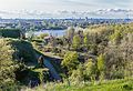
The Vantaanjoki flows through the northern outskirts of Helsinki and flows into the sea in the Vanhakaupunki district, the original founding site of Helsinki. Rather untypically for Finland, there are only nine small lakes or ponds in Helsinki's urban area. The terrain, like the rest of southern Finland, is dominated by rounded hills, i.e. flat, gently rising hills of granite rock. The town has also given its name to a local variety of granite, or unakite, in the form of the rock called helsinkite. The highest point in the town area is a mound of construction excavation in the Malminkartano subdivision, at 90 metres. The highest natural elevation is in the Kivikko sub-area, reaching 62 metres above sea level.
Of Helsinki's land area, about half is made up of various green areas (forests, parks, agricultural land) (according to another source, 36%, of which 22% is forest). Large contiguous green areas are found mainly in the northern and eastern outskirts. In addition to the boreal coniferous forest typical of Finland, there are also isolated groves of deciduous forest. On the outer islands, the vegetation is sometimes quite sparse, but on the other hand, a great variety of bird species live there. There are 50 nature reserves in Helsinki with a total area of 684 ha.
Of the approximately 300 islands, more than half are smaller than 0.5 ha; about 50 islands are larger than 3 ha. The best-known islands include the excursion islands of Korkeasaari (with a zoo), Seurasaari (with an open-air museum) and Pihlajasaaret. The historic sea fortress of Suomenlinna stretches over several artificially connected islands. The largest islands in terms of area include the residential areas of Laajasalo and Lauttasaari and the garrison island of Santahamina.
· 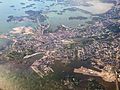
Helsinki from the air
· 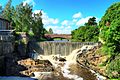
River Vantaanjoki in Vanhakaupunki
· 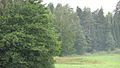
Forest in Viikki district
· 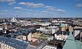
View of the centre of Helsinki
· 
View from Vallisaari to Suomenlinna and Helsinki
Settlement structure
The city centre is located on a peninsula in the southwest of the city area. Characteristic of Helsinki is the great difference between the historically grown, densely built core city (kantakaupunki) on the peninsula and the much more generously laid out new development areas that have been built since the middle of the 20th century, which adjoin to the north, west and east. The latter extend into the territory of the neighbouring cities of Espoo, Kauniainen and Vantaa, with which Helsinki has grown into a coherent agglomeration. The four politically independent cities form the so-called capital region (pääkaupunkiseutu), effectively a single large city with over one million inhabitants. The contiguous urban area (taajama) defined by Statistics Finland, which is based on actual population rather than municipal boundaries, had a land area of 631.11 km² and a population of 1,159,211 at the end of 2011. Helsinki's wider catchment area includes the Helsinki region (Helsingin seutu) with the municipalities of Kirkkonummi, Vihti, Nurmijärvi, Tuusula, Kerava, Sipoo, Järvenpää and Hyvinkää. A total of 1.3 million people live in this metropolitan area, which accounts for just over a quarter of Finland's total population.
The average population density in Helsinki is 2787 p.e./km². In the core city, high values of up to 19,500 inhabitants/km² (Punavuori) are reached, while the outer districts with their often very generously laid out settlements interspersed with extensive green areas (lähiö) are comparatively sparsely populated. Completely uninhabited areas are mainly found in the large district of Östersundom, which only became part of Helsinki in 2009 through incorporation.
enlarge and show information about the picture
![]()
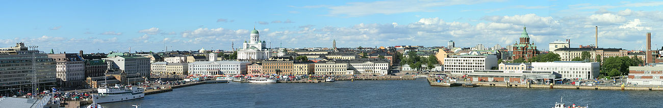
View of the southern harbour, the cathedral and the Uspenski Cathedral
Administrative structure
The basis of the official division of Helsinki are the 137 sub-areas (osa-alue in Finnish) with their subordinate 369 small areas (pienalue). There are two parallel systems: the sub-areas are grouped in different ways into 59 city districts (kaupunginosa) on the one hand, and 34 city boroughs (peruspiiri) on the other. The urban districts are in turn grouped into eight metropolitan districts (suurpiiri). However, the practical significance of these administrative units is limited, and the names used in everyday life for the various areas often differ from the official ones.
The 59 districts of Helsinki by metropolitan area:
| Southern metropolitan area | Eira, Etu-Töölö, Kaartinkaupunki, Kaivopuisto, Kamppi, Katajanokka, Kluuvi, Kruununhaka, Länsisatama, Lauttasaari, Punavuori, Suomenlinna, Taka-Töölö, Ullanlinna |
| Western metropolitan area | Haaga, Kaarela, Konala, Laakso, Meilahti, Munkkiniemi, Pitäjänmäki, Ruskeasuo |
| Central metropolitan area | Alppiharju, Hermanni, Kallio, Käpylä, Koskela, Kumpula, Pasila, Sörnäinen, Toukola, Vallila, Vanhakaupunki |
| Northern metropolitan area | Oulunkylä, Pakila, Tuomarinkylä |
| Northeast metropolitan area | Malmi, Pukinmäki, Suurmetsä, Suutarila, Tapaninkylä, Viikki |
| Southeast metropolitan area | Herttoniemi, Kulosaari, Laajasalo, Mustikkamaa-Korkeasaari, Santahamina, Tammisalo, Ulkosaaret, Vartiosaari, Villinki |
| Eastern metropolitan area | Mellunkylä, Vartiokylä, Vuosaari |
| Greater Östersundom County | Östersundom, Salmenkallio, Talosaari, Karhusaari, Ultuna |
For more details see: List of Helsinki districts
In 1812, Johan Albrecht Ehrenström came up with the idea of also giving names to the blocks of houses in the city centre. From 1820 to 1900, these were each given an animal or flower name, e.g.: Kortteli 32 Dromedaari (Swedish: Kvarteret 32 Dromedaren, German: Häuserblock 32 Dromedar).
Climate
The climate of Helsinki combines features of continental and maritime climate. The average annual temperature in Helsinki is 5.9 °C, the annual average precipitation is 655 mm. The most precipitation falls in August (80 mm monthly average), the least in April (32 mm). The coldest month is February with an average temperature of -4.7 °C, the warmest is in July with 17.8 °C. In summer, maximum temperatures of up to 30 °C can be reached. In winter, temperatures below -10 °C are not uncommon; the lowest temperature ever recorded in Helsinki was -34.3 °C (10 January 1987). Due to the sea wind, the perceived temperature is often even lower than the measured temperature, especially in winter (wind chill).
The water temperature varies from 1 °C in February to 17 °C in August. In the numerous sheltered, low bays, the water temperature can also reach higher values in summer.
The first snow usually falls in mid-November. A permanent snow cover usually exists from the end of December until the end of March. In winter, the Gulf of Finland freezes over, so icebreakers are needed to keep a shipping channel clear.
Helsinki lies at the same latitude as the southern part of Alaska and the southern tip of Greenland. Even though the climate in Helsinki is warmer due to the North Atlantic Current, the northern location ensures that the brightness varies greatly throughout the year. At the time of the summer solstice, the day lasts almost 19 hours, and even during the remaining hours it does not get completely dark, as the sun is only just below the horizon (so-called white nights). At the time of the winter solstice, the daylight lasts less than 6 hours, even at noon the sun is low in the sky.
| Helsinki | ||||||||||||||||||||||||||||||||||||||||||||||||
| Climate diagram | ||||||||||||||||||||||||||||||||||||||||||||||||
| ||||||||||||||||||||||||||||||||||||||||||||||||
| Monthly average temperatures and precipitation for Helsinki
Source: Finnish Meteorological Institute. Data are based on monthly averages from 1981-2010. | ||||||||||||||||||||||||||||||||||||||||||||||||||||||||||||||||||||||||||||||||||||||||||||||||||||||||||||||||||||||||||||||||||||||||||||||||||||||||||||||||||||||||||||||||||||||||||||||||||||||||||||||||||||||||||||||


Author
AlegsaOnline.com Helsinki — capital and largest city of Finland Leandro Alegsa
URL: https://en.alegsaonline.com/art/43436
Sources
- yorkspace.library.yorku.ca : "Place Names in the Construction of Social Identities: The Uses of Names of Helsinki"
- maanmittauslaitos.fi : "Area of Finnish Municipalities 1.1.2018"
- pxnet2.stat.fi : "Ennakkoväkiluku kuukausittain sukupuolen mukaan alueittain, elokuu 2018"
- pxweb2.stat.fi : "Population according to language and the number of foreigners and land area km2 by area as of 31 December 2008"
- pxweb2.stat.fi : "Population according to age and gender by area as of 31 December 2008"
- vero.fi : "List of municipal and parish tax rates in 2011"