Heidelberg: city of learning, history and the Neckar valley
Heidelberg is a university city in southwestern Germany on the Neckar, noted for its historic old town, university (founded 1386), castle ruins, cultural life and mild oceanic climate.
Heidelberg is a mid-sized city in southwestern Germany, situated on the banks of the Neckar river. It lies in the historic Baden-Württemberg region and is administered within a larger state framework. The city has a population on the order of 150,000 people and combines an active urban centre with surrounding green hills and river valleys.
Image gallery
10 Images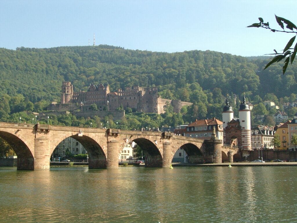


University and intellectual life
Heidelberg's identity is strongly shaped by its university, the University of Heidelberg, which dates from the late 14th century and is one of the oldest universities in the German-speaking world. The institution has long been prominent in medicine, natural sciences and the humanities, attracting domestic and international students and researchers and giving the city a lively academic and cultural atmosphere.
Historic centre and landmarks
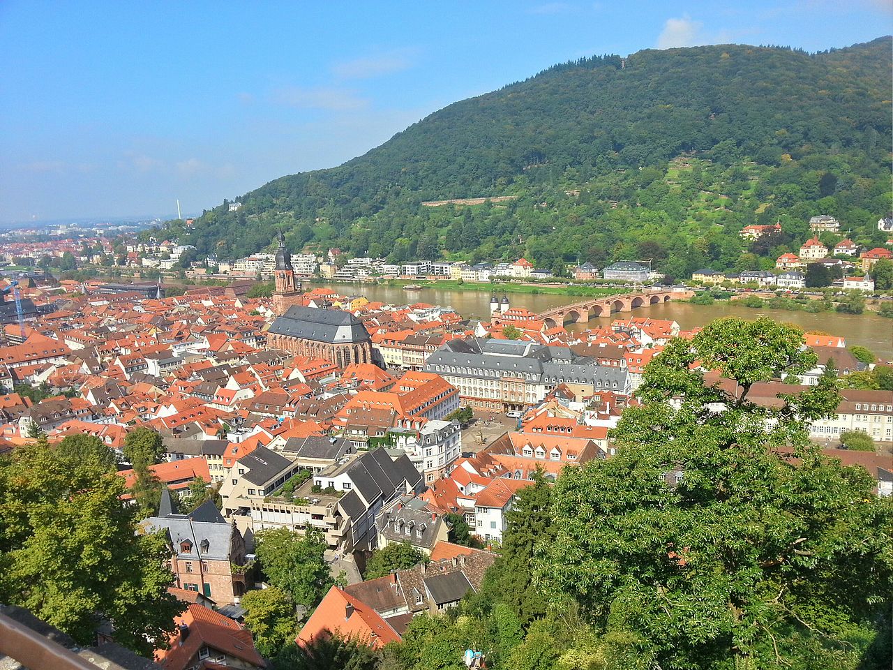
The city's compact old town (Altstadt) and the partially ruined Heidelberg Castle are among its best-known sights. Narrow streets, baroque facades and riverside promenades draw many visitors. Major points of interest include:
- Heidelberg Castle, a dramatic hilltop ruin with terraces and gardens;
- The old stone bridge spanning the Neckar, linking the Altstadt with the opposite bank;
- Churches, university buildings and museums that reflect centuries of local history.
Climate and setting
Heidelberg has a temperate oceanic climate, classified as Cfb in the Köppen climate classification. Winters are generally mild for central Europe and summers are warm but not extreme, a factor that has helped make the valley setting appealing for residents and visitors alike.
Beyond tourism and education, the regional economy includes research institutes, small and medium-sized enterprises, and service industries. Cultural life features theatres, festivals and museums, and the city has long associations with philosophy and Romantic-era literature. Heidelberg is often cited as an example of a historic European university town that balances conservation of heritage with modern research and urban amenities.


Geography
Location
Heidelberg lies partly in the Upper Rhine lowlands, mainly on the left bank of the lower Neckar before its outflow from the Odenwald in an elongated, upstream tapering valley floor, bordered by Königstuhl (568 m) and Gaisberg (375 m). The Neckar flows here from east to west, on the right bank of the Neckar rises the Heiligenberg (445 m). The Neckar flows into the Rhine about 22 kilometres northwest, measured from the end of the valley floor, in Mannheim. The towns incorporated in the 20th century extend across the Neckar valley into the Bergstrasse, which runs along the edge of the Odenwald. The city lies in the Rhine-Neckar metropolitan region, a conurbation of 2.35 million inhabitants, which includes parts of southern Hesse and the Rhineland-Palatinate Vorderpfalz in Baden-Württemberg, the two city districts of Mannheim and Heidelberg, and the western and southern municipalities of the Rhine-Neckar district.
Floor space allocation
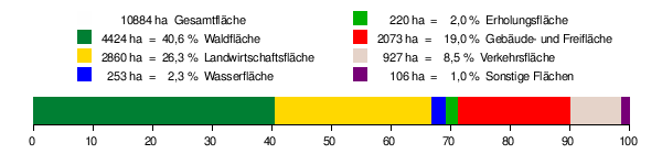
According to data from the State Statistical Office, as of 2015
flora and fauna
Since Heidelberg is located in one of the warmest regions of Germany, some special plants thrive here by Central European standards, such as almond and fig trees and olive trees, which are planted outdoors. The "balcony" of the city with many exotic plants is the Philosophenweg opposite the old town. There, in the year 2000, winegrowing was successfully started again.
In addition, there are free-living populations of collared parakeets in Heidelberg, whose ornithological name is Psittacula krameri, as well as a free-living population of the Siberian swan goose, which can be found mainly on the Neckar island in front of Bergheim and on the Neckar meadows. However, nature conservation experts often refer to the problem of such naturalizations of alien species (neobiota), which usually originate from escaped zoo or domestic animals (captive escapees).
Nature Conservation
→ Main article: List of nature reserves in Heidelberg
The following five nature reserves exist in the Heidelberg city area. This means that 85.4 hectares of the city area are under nature protection, or 0.78 percent.
- Former red sandstone quarry at the Neckarhalde: 13.4 ha; Ziegelhausen district
- Felsenmeer, Russenstein, Michelsbrunnen Nature Park: 11.2 ha; Heidelberg district
- Leimen quarry: 22.0 ha (of which 4.0 ha in the city of Heidelberg); Heidelberg district
- Lower Neckar: Altneckar Heidelberg-Wieblingen: 45.2 ha; Wieblingen district
- Lower Neckar: Altneckar Wörth-Weidenstücker: 16.7 ha (of which 11.6 ha in the Heidelberg urban area)
Administrative structures, region
Heidelberg is the seat of the district administration of the Rhein-Neckar-Kreis. The city itself is a district-free city within the administrative district of Karlsruhe. Heidelberg is part of the Rhine-Neckar conurbation, which includes parts of southern Hesse and the Anterior Palatinate in Rhineland-Palatinate in Baden-Württemberg, the two city districts of Mannheim and Heidelberg, and the western and southern municipalities of the Rhine-Neckar district. Together with a large number of other municipalities, it forms the economic area known as the Rhine-Neckar Triangle. In 2005, the Rhine-Neckar Triangle became a European Metropolitan Region.
Within the Rhine-Neckar region, Heidelberg forms a regional centre alongside Mannheim, of which a total of 14 are designated for the whole of Baden-Württemberg according to the 2002 State Development Plan. The upper centre of Heidelberg also assumes the function of a middle area within the administrative structures of the state for the surrounding communities of Dossenheim, Schriesheim, Wilhelmsfeld, Heddesbach, Heiligkreuzsteinach, Schönau, Neckargemünd, Wiesenbach, Bammental, Gaiberg, Leimen, Nußloch, Sandhausen and Eppelheim.
Neighboring communities
The following towns and municipalities border directly on the city of Heidelberg, starting in the west in a clockwise direction: Eppelheim, Plankstadt, Mannheim, Edingen-Neckarhausen, Dossenheim, Schriesheim, Wilhelmsfeld, Schönau, Neckargemünd, Bammental, Gaiberg, Leimen, Sandhausen, Oftersheim (except for the city of Mannheim, all belong to the Rhine-Neckar district).
City breakdown
The city of Heidelberg is divided into 15 districts and 47 boroughs. These include seven former neighboring villages that were incorporated until 1975. Some districts also include other small, separately located residential areas and farmsteads.
see also: List of places in Heidelberg
| ||||||||||||||||||||||||||||
- Downtown
One of the oldest parts of Heidelberg is the Old Town, the historic core of the city located between the Neckar River and the Königstuhl. This is where most of the sights, such as Heidelberg Castle, are located. Because of its rich cultural heritage, Heidelberg applied for recognition of the Old Town as a UNESCO World Heritage Site in 2004 and 2007. This part of the city also includes areas further out, such as the Molkenkur, Kohlhof and Speyerer Hof. Together with the Old Town, Bergheim, which lies to the west of the Old Town, forms the inner city. The former village is older than the old town. Remains of human settlement can be traced back to the early Stone Age. Bergheim was first mentioned in the Lorsch Codex in 769. In 1392 the village of Bergheim was dissolved and the inhabitants were forcibly resettled in the rapidly growing residential town of Heidelberg. During the industrialization at the end of the 19th century, when the city expanded to the west, the area was settled again.
- Center
Immediately southwest of Heidelberg's city center is Weststadt, which merges into Südstadt to the south. These districts were created as a result of Heidelberg's rapid population growth during industrialization as a Gründerzeit quarter (Weststadt) and after the Second World War (Südstadt). Südstadt includes the Mark Twain Village and the Campbell Barracks, where US soldiers and their dependents were housed until the official withdrawal of US troops in 2014. Currently (as of January 2016), a new use is being sought in the course of a conversion project.
To the west, a new urban district adjoins Bergheim and the Weststadt: The so-called Bahnstadt is currently still under construction, but only the western third is missing to the master plan. A first construction phase was inaugurated in July 2014. One of the largest passive house developments in the world is to be built on the site of the former freight and marshalling yard.
- South
Further south lies the district of Rohrbach with Hasenleiser and Bierhelder Hof. To the southeast Heidelberg is completed by the two still young districts Boxberg and Emmertsgrund.
- West
The largest and at the same time oldest district of Heidelberg is Kirchheim. Already in the Bronze Age there were settlements in the present municipal area. Several Carolingian graves, which were found in the 1970s during excavations at the "Spinne", testify to the importance of Kirchheim as an important junction between the monasteries of Lorsch and Mainz. Kirchheim forms the southwestern part of Heidelberg and was incorporated in 1920. Also counted as part of Kirchheim are the Kurpfalzhof, Kirchheimer Hof, the Patrick-Henry-Village (a settlement of the US Army founded in 1947, which is still (as of 2016) used as an emergency refugee shelter after the withdrawal of the troops in 2014. In addition, the Patrick Henry Village is an initial reception centre and a coordination and distribution centre for refugees), the Pleikartsförster Hof and Neurott.
The Im Mörgelgewann emergency housing area is located on the edge of Weststadt in the direction of Kirchheim. The neighbourhood is socially and visually remote; it can only be reached via a cul-de-sac. It was originally built to accommodate refugees after the Second World War. In 2008, around 300 people live here who were housed as homeless people by the city of Heidelberg.
Pfaffengrund is located on the western edge of Heidelberg. It can be divided into an industrial area to the north and a residential area to the south. The name Pfaffengrund is derived from the medieval field name, the area itself was used as farmland until 1920.
Further north lies Wieblingen with the Grenzhof and the Ochsenkopf. Like Kirchheim and Pfaffengrund, Wieblingen became a district of Heidelberg in 1920. Wieblingen was first mentioned in documents in the Lorsch Codex in 767.
- North
Opposite the city centre, on the northern bank of the Neckar, lies the district of Neuenheim. The development of Neuenheim already began in pre-Roman times. It was the first district of Heidelberg to become part of the city area by incorporation in 1891. The new campus of the Ruprecht Karls University is located in Neuenheimer Feld.
Further north lies Handschuhsheim, which was incorporated a few years after Neuenheim, in 1903. The name Handschuhsheim probably goes back to a landowner in the early Middle Ages, in whose coat of arms a hand or a glove was depicted.
- East
In the east, on the south side of the Neckar, lies Schlierbach. It was first mentioned in a document in 1245. The area is one of the upscale residential areas of Heidelberg.
On the other side of the Neckar lies Ziegelhausen with the district of Peterstal. Ziegelhausen was mentioned in a document in 1220, a few years before Schlierbach. The area was probably already settled in Roman times. Ziegelhausen was incorporated into Heidelberg in 1975 - against the will of the vast majority of its inhabitants.
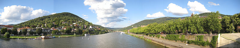
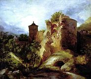
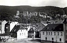
enlarge and show information about the picture
![]()
The Neckar river crosses Heidelberg. Panorama from the Theodor-Heuss-Bridge. On the left Neuenheim with Neckar meadows, on the right old town.
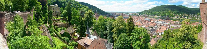
enlarge and show information about the picture
![]()
Heidelberg Castle: Panorama with view of the castle terraces and the old town.
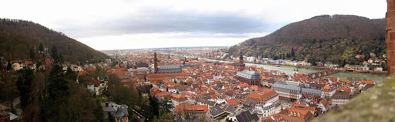
enlarge and show information about the picture
![]()
Panoramic view from Heidelberg Castle to the Old Town with the Heiliggeistkirche across the Neckar River
Climate
The climate in the region in the protected location between the Palatinate Forest and the Odenwald is mild all year round and 65 percent of it is determined by the supply of maritime air masses from western directions. Compared to the nearby Rhine plain, Heidelberg's location at the exit of the Neckar valley results in an above-average frequency of easterly winds. The slopes of the Odenwald favor cloud formation and precipitation. The DWD climate station in Heidelberg measured an average temperature of 11.1 °C and precipitation of 745 mm per year between 1971 and 2000. The warmest month is July with an average of 20.1 °C, the coldest is January with 2.5 °C. Temperatures above 30 °C are not uncommon in midsummer. Most precipitation falls in July and the driest month is March .
| Heidelberg | ||||||||||||||||||||||||||||||||||||||||||||||||
| Climate diagram | ||||||||||||||||||||||||||||||||||||||||||||||||
| ||||||||||||||||||||||||||||||||||||||||||||||||
| Monthly average temperatures and precipitation for Heidelberg
Source: DWD, data: 2015-2020, wetterkontor.de | |||||||||||||||||||||||||||||||||||||||||||||||||||||||||||||||||||||||||||||||||||||||||||||||||||||||||||||||||||||||||||||||||||||||||||||||||||||||||||||||||||||||||||||||||||||||||||||||||||||||||||||||||||||||||||||||||||||||||||||||||||||||||||||||||||||||||||


History
→ Main article: History of Heidelberg
The city of Heidelberg was founded in the 12th century, but its history goes back to Celtic and Roman times. From the 13th century until 1720, Heidelberg was the residence of the Palatine Counts of the Rhine and the capital of the Electoral Palatinate.
Previous story
Near Heidelberg, in the municipality of Mauer, the lower jaw of a prehistoric man (lower jaw of Mauer) was found in a sand pit in 1907, one of the oldest finds of the genus Homo in Europe. Neanderthal man is descended from this extinct hominid species Homo heidelbergensis (Heidelberg man).
Celtic
From about 500 BC, the Celts founded a larger fortified settlement on the Heiligenberg. Its double ramparts, built as protection against the advancing Germanic tribes, can still be seen. 200 years later, this complex was abandoned for unexplained reasons.
Romans
Roman Heidelberg existed from the 1st to the 3rd century A.D. Around 70 A.D. the Romans founded a camp in today's Neuenheim, which was replaced by two stone forts around 90. At first a wooden bridge led across the Neckar, from around 200 onwards a stone pillar bridge. A temple of Mercury was built on the summit of the Heiligenberg, and the cult of Mithras was also widespread in Heidelberg. In Roman times, the main town in the region was the neighbouring Lopodunum (today Ladenburg), but a flourishing pottery centre also developed around the military camp in Heidelberg (whose Latin name is unknown).
After 260, the Romans had to retreat to the Rhine before the Germanic tribe of the Alamanni, who had broken through the Limes and invaded Roman territory. The victory of the Merovingian king Clovis I over the Alamanni in 506 finally made Heidelberg part of the Frankish Empire, and at the same time the area was Christianized.
Medieval
In 870, the monastery of St. Michael was founded on the summit of the Heiligenberg on the site of the old temple of Mercury as a branch monastery of the monastery of Lorsch, which at that time was vying with the diocese of Worms for supremacy in the region. This was later followed by another branch, the St. Stephen's Monastery, and the Neuburg Monastery.
The oldest written reference to Heidelberg dates back to 1196, but it can be assumed that the town had already been established in the course of the 12th century. At that time Heidelberg was owned by the bishopric of Worms and consisted of the Upper Castle on the Molkenkur on the slope of the Königsstuhl and a castle hamlet in the area of St. Peter's Church at the foot of the mountain. Many of Heidelberg's present-day districts can be traced back to villages that had already been established during the Frankish period in the 6th century. Some of them were first mentioned in documents in the Lorsch Codex, Neuenheim and Handschuhsheim around 765.
The predecessor of Heidelberg Castle was built in the 13th century on the Jettenbühl. Probably at the same time, the town was laid out according to plan in the area between the Königstuhl and the Neckar with a rectangular ground plan and the market square in the centre. This town complex occupied the eastern part of today's old town as far as Grabengasse. It was surrounded by a city wall and a bridge led over the Neckar.
Emperor Frederick I Barbarossa had appointed his half-brother Conrad the Hohenstaufen as Count Palatine of the Rhine in 1156. The Palatinate was ruled by the Wittelsbach dynasty and developed into a larger territorial entity within the Holy Roman Empire. In 1225, the Count Palatine of the Rhine received Heidelberg, formerly in Worms, as a fief. In 1356, in the Golden Bull, the Palgraves near the Rhine were granted the electoral dignity. From then on they were known as the Electors of the Palatinate, and their domain was known as the Electoral Palatinate. Initially, the counts palatine did not have a fixed residence, but stayed at various places in their domain. Already in the 13th century Heidelberg had developed the character of a residence town. When in the 14th century the travelling rule was abandoned, the city was able to assert itself against Neustadt an der Haardt and became the capital of the Electoral Palatinate.
In 1386, Ruprecht I founded the University of Heidelberg as the third university in the Holy Roman Empire (after Prague and Vienna). It is the oldest university in Germany. In 1392 Heidelberg was extensively expanded, the city area almost doubled in size and corresponded to today's old town. Heidelberg benefited from the reign of Ruprecht III, who was elected Roman-German king in 1400, by building the Heiliggeistkirche. His successors made Heidelberg University a stronghold of early humanism towards the end of the 15th century.
Modern Times
Martin Luther's reformatory ideas had already spread through southwestern Germany in the first half of the 16th century. In 1545/1546, the population decided to accept the new faith, the introduction of which Paul Fagius was commissioned by Frederick II to prepare. Under Elector Ottheinrich (1556-1559), the Reformation was finally introduced in the Electoral Palatinate. After the transition to Calvinism, Heidelberg attracted students and scholars from all over Western Europe and was considered the third Geneva after Leiden. Thus the Heidelberg Catechism was published in Heidelberg in 1563, and in 1572 the first complete German translation of the Institutio Christianae Religionis, the main work of John Calvin. Towards the end of the century a number of magnificent Renaissance buildings were erected in Heidelberg, all of which were destroyed in the War of the Palatinate Succession - only the façade of the Haus zum Ritter survived the devastation. The castle was also considerably extended at that time and transformed from a medieval castle into a modern residence.
In order to be able to offer his wife, the English king's daughter Elisabeth Stuart, a court life befitting her station, Elector Frederick V (1610-1623) had Heidelberg Castle remodeled by building the Hortus Palatinus. On the political terrain, Frederick was involved in the turmoil of the Thirty Years' War as leader of the Protestant Union when he had himself elected King of Bohemia in 1619. However, he was unable to prevail against the Catholic emperor and was defeated at the Battle of the White Mountain in 1620. Because of his short reign, he went down in history as the Winter King. In the first weeks of September 1622, Tilly successfully laid siege to Heidelberg as an army commander of the Catholic League. The capture of Heidelberg took place on September 16. The city, like all of the Electoral Palatinate on the right bank of the Rhine, remained under Bavarian occupation (while the Electoral Palatinate on the left bank of the Rhine became Spanish) until the peace treaties of Münster and Osnabrück. However, the city was repeatedly conquered and was occupied by Swedish troops between 1632 and 1634. During this time, Duke Maximilian I of Bavaria donated the Bibliotheca Palatina to Pope Gregory XV, and it has since been kept in the Bibliotheca Vaticana (and in this way safely survived Heidelberg's later destruction by Louis XIV's troops in the War of the Palatinate Succession). Heidelberg was badly hit by the war, and the population suffered great hardship. In the Peace of Westphalia, which ended the Thirty Years' War in 1648, the Electoral Palatinate was restored, but it lost much of its political weight.
When Elector Charles II died childless in 1685, the Palatinate-Simmern line of the House of Wittelsbach became extinct, and the electorship passed to the Catholic collateral line Palatinate-Neuburg. The War of Palatinate Succession resulted from the inheritance claims that the French King Louis XIV now raised with reference to his sister-in-law Elisabeth Charlotte (better known as Liselotte of the Palatinate). In the course of this war Heidelberg was captured twice, in 1688 and 1693, by French troops and completely devastated. After the War of Succession ended in 1697, the destroyed Heidelberg was rebuilt in the Baroque style on a medieval ground plan. The now Catholic electors settled Jesuits in the city.
Heidelberg Castle was uninhabitable after its destruction by the French, but in any case it no longer corresponded to the Baroque taste of the time, which preferred lavish palace complexes modelled on Versailles. Plans to build such a residence on the plain in the area of today's Bergheim district failed due to the resistance of Heidelberg's citizens, and so in 1720 Charles III Philip decided to move his residence to Mannheim after a dispute with Heidelberg's Protestants over the Protestant Heiliggeistkirche, which the Catholic elector claimed for himself. In the square city, which was far more in keeping with the Baroque spirit of the times and the Elector's interest in representation than medieval Heidelberg, he had the magnificent Mannheim Palace built. Heidelberg lost its position as a political centre of power and also suffered economically as a result of the departure of the court. However, Heidelberg also profited from the reign of Elector Carl Theodor (1743-1799) through the construction of the Old Bridge and the Karlstor. The repair of the castle was stopped in 1764 after a devastating lightning strike.
1803 until 1933
In 1803, the main Reich deputation treaty dissolved the Electoral Palatinate, and the territories on the right bank of the Rhine, and thus also Heidelberg, were assigned to Baden, which was soon elevated to the status of a grand duchy. The Grand Duke of Baden, Karl Friedrich (1771-1811), made the university a state-financed educational institution and helped it to rise again to become a renowned educational institution. In his honour and that of the university's founder, Elector Ruprecht I, Heidelberg University was given the new name "Ruprecht-Karls-Universität".
At the beginning of the 19th century, the Neckar city became one of the most important places of German Romanticism, favoured by the beautiful landscape and the picturesque castle ruins. The work of poets such as Friedrich Hölderlin, Ludwig Achim von Arnim, Clemens Brentano and Joseph von Eichendorff became known as "Heidelberg Romanticism". Arnim and Brentano published a collection of German folk songs under the title Des Knaben Wunderhorn in Heidelberg between 1806 and 1808. A circle of artists around the painters Carl Philipp Fohr, Carl Rottmann and Ernst Fries also emerged in Heidelberg.
During the Vormärz, national, liberal and democratic ideas were spread at Heidelberg University. After the beginning of the March Revolution, liberal and democratic politicians from southwestern Germany gathered at the Heidelberg Assembly on March 5, 1848, which provided decisive impetus for the Pre-Parliament and thus for the constitution of the Frankfurt National Assembly. After the failure of the National Assembly, the May Uprising in Baden was put down by Prussian troops called in to help. In Heidelberg, too, there were fights against liberal rebels.
Industrialization passed by the Neckar city without leaving any major traces. Tourism developed into an important economic factor in Heidelberg from the early 19th century, especially after the city was connected to the railway network in 1840, and the number of students also increased, many of whom belonged to the student fraternities. Joseph Victor von Scheffel's poem Alt-Heidelberg, du feine (later a popular student song set to music) and the play Alt-Heidelberg, which premiered in 1901, made Heidelberg a symbol of student life in the 19th century.
In the last quarter of the 19th century, Heidelberg experienced rapid expansion as the urban area was enlarged by numerous incorporations. Heidelberg's population rose from 20,000 in 1871 to 85,000, more than four times that number, in 1933. At the same time, the infrastructure was expanded with the introduction of the tram and the mountain railway and the canalization of the Neckar River (in the 1920s). In 1930, generous donations from influential U.S. citizens made possible the construction of the lecture hall building of the New University on Universitätsplatz. A commemorative plaque inside the lecture hall building names the Chrysler family, among others.
The election results of the NSDAP in Heidelberg were mostly above the average of the results in the Reich or in Baden: In the Reichstag election on 20 May 1928, 2.6% in the Reich, 2.9% in Baden, and 4.4% in Heidelberg; in the Reichstag election on 14 September 1930, 18.3% in the Reich, 19.2% in Baden, and 30.2% in Heidelberg.
· 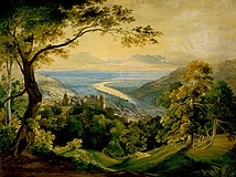
Heidelberg Castle in front of the Rhine Plain, Carl Rottmann, 1815
· 
Heidelberg Castle was destroyed by the French during the War of the Palatinate Succession. Painting by Carl Blechen, 1829
· 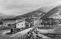
Departure of a train from Heidelberg station, lithograph from 1842
· 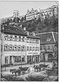
The grain market with horse-drawn carriages and statue of the Virgin Mary, 1881
The National Socialist era and the Second World War
After the transfer of power to the NSDAP on January 30, 1933, one of the darkest chapters of the city began, the organized discrimination against Jews and other "non-Aryans". The NSDAP became the strongest party in the city in the Reichstag elections of 5 March 1933, with 45.8% of the votes cast (Reich: 43.9%; Baden: 45.4%). In April 1933 all "non-Aryan" civil servants were placed on forced leave, and by 1939 Heidelberg University had lost more than a third of its teaching staff for racial or political reasons (in 1930 9% of the teaching staff were of Jewish denomination). During the Night of Broken Glass on November 9, 1938, Heidelberg's National Socialists burned down the synagogues in the Old Town and in Rohrbach. At the same time, they destroyed the prayer hall at Plöck 35 and vandalized or looted numerous shops and homes of Jewish citizens in full view of the population and the police. The next day 150 Heidelberg Jews were taken to the concentration camp Dachau for alleged protective custody in order to force them to emigrate and to aryanize their property. On October 22, 1940, in the "Wagner-Bürckel Action", over 6000 Jews from Baden, including 280 from Heidelberg, were deported to the Camp de Gurs internment camp in southwestern France. Only a few survived.
The visible architectural legacy is the Thingstätte on the Heiligenberg, an open-air stage erected between 1934 and 1935 by the Reich Labour Service and Heidelberg students. The cemetery of honour on the Ameisenbuckel was also built by the Reich Labour Service in 1934. In 1935, the Reichsautobahn Heidelberg-Mannheim was inaugurated, now known as the A 656, and at both ends, in Mannheim and Heidelberg, it was lowered to federal highway level, now the B 37. Until the late 1990s, the A 656 led directly into Mannheim and Heidelberg.
Heidelberg, which was filled with military hospitals, was one of the few major German cities to survive the Second World War almost unscathed. The first air raid was carried out by the Allies on the night of September 19-20, 1940, when the Pfaffengrund district was hit by bombs. On September 23, 1940, a German air raid on Cambridge followed in retaliation for this attack on Heidelberg. Smaller air raids in 1944 and 1945 caused only minor damage. Of Heidelberg's 9,129 residential buildings, a total of 13 were totally destroyed (0.14%), 32 severely damaged (0.35%), 80 moderately damaged (0.87%), and 200 slightly damaged (2.19%). Out of 25,933 dwellings, 45 were totally destroyed (0.17%) and 1,420 damaged (5.47%). The total housing loss due to air raids was 0.8%. The freight station and the Tiergarten were heavily damaged by bombs and artillery fire respectively. A total of 241 people lost their lives in Heidelberg as a result of air raids.
Why Heidelberg was almost spared is not entirely clear. Numerous contemporary witnesses from the Old Town, West Town and Pfaffengrund report that leaflets were dropped in Heidelberg a few months before the US invasion with the inscription "Heidelberg we want to spare, because we want to live in it ourselves"; only the exact wording varies slightly depending on the report. The announcement of sparing and liberation was thrown away by all contemporary witnesses, so that no copy could be archived until today.
During their retreat on 29 March 1945, the Wehrmacht blew up the Old Bridge, among other things. On March 30, the American troops of the 63rd Infantry Division of the 7th U.S. Army marched in without meeting any significant resistance. They were able to take over many buildings in the city for their purposes, including the Großdeutschland-Kaserne, which has since borne the name Campbell Barracks. Until the end of the war, the German Infantry Regiment 110 was stationed there, subordinated to the 33rd Infantry Division and from the end of 1940 to the 112th Infantry Division and deployed in the French and Russian campaigns.
· 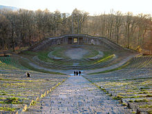
The Thing site on the Heiligenberg, built in 1935
· 
View from the Old Bridge to the Castle, 1939
· 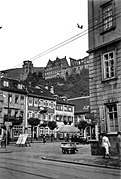
View from the main street to the castle, 1939
After the Second World War
Unharmed Heidelberg attracted many bombed-out and displaced Germans after World War II. Heidelberg became part of the American occupation zone and the location of high command posts of the US Army and later also of NATO. For this, the American authorities expropriated real estate, which initially caused resentment. From 1948 to 2013, the Campbell Barracks in Heidelberg were home to the headquarters of the United States Army Europe (USAREUR), the former 7th US Army. Until 2013, the city was also home to NATO's Central Europe Headquarters.
In October 2009, it was announced that USAREUR's headquarters would be relocated to Wiesbaden. In August 2011, the tradition-rich V. US Army Corps left Heidelberg and moved to Wiesbaden. In September 2013, Campbell Barracks was officially closed by the US Army. With the move to the new headquarters in Wiesbaden-Erbenheim, the 65-year history of USAREUR - and American troops in general - came to an end in Heidelberg in 2013. In 2008, the American forces had still occupied nearly 200 hectares of land, including for two barracks, two housing developments, and a military hospital (Nachrichten Kaserne). In 2010, around 16,000 U.S. Americans lived in Heidelberg; at that time, Americans accounted for ten percent of Heidelberg's population.
The Ruprecht Karls University resumed teaching in January 1946 as the second West German university after Göttingen. Even before the war, some of the university's facilities had been moved from the Old Town campus to Neuenheim on the other side of the Neckar River, and in 1951 work began on the construction of a completely new campus, the Neuenheimer Feld, on the western edge of the city. By the mid-1970s, the development of the 120-hectare site was essentially complete. In 1955, the main train station was moved to its present location about 1.2 kilometers west of the old site. The vacated area was used for the construction of numerous administrative buildings on the Kurfürstenanlage. To accommodate Heidelberg's growing population, two entirely new residential areas, Boxberg and Emmertsgrund, were built in the south of the city in the 1960s and 1970s.
With the incorporation of the municipality of Ziegelhausen, located in the Neckar valley, Heidelberg's expansion in terms of area was completed in 1975. During the term of office of Lord Mayor Reinhold Zundel (1966 to 1990), the old town was redeveloped, the 1.6-kilometre-long main street was transformed into one of the longest pedestrian zones in Europe and Bismarckplatz was given its present form.
In the 1970s and 1980s, the RAF terrorist organization carried out two attacks against American military installations in Heidelberg. On May 24, 1972, an explosive attack on the U.S. headquarters of the 7th U.S. Army in Campbell Barracks killed the American soldiers Clyde R. Bonner, Charles L. Peck and Ronald A. Woodward and seriously injured five others. The September 15, 1981 assassination attempt on the commander-in-chief of U.S. land forces in Europe, General Frederick James Kroesen, with a reactive Soviet-type RPG-7 anti-tank rifle at Heidelberg's Karlstor failed because the Baden-Württemberg LKA had assigned him an armored Mercedes-Benz sedan shortly before, after suspicious persons had been observed observing Kroesen.
An application for the inclusion of the castle and the old town in the UNESCO World Heritage List was rejected in 2005 and 2007.


Related articles
Author
AlegsaOnline.com Heidelberg: city of learning, history and the Neckar valley Leandro Alegsa
URL: https://en.alegsaonline.com/art/43238
Sources
- destatis.de : "Alle politisch selbständigen Gemeinden mit ausgewählten Merkmalen am 31.12.2018 (4. Quartal)" · web.archive.org
- destatis.de : destatis.de/DE/ZahlenFakten/LaenderRegionen/Regionales/Gemeindeverzeichnis/Administrativ/…
- destatis.de : "Gemeinden in Deutschland nach Fläche, Bevölkerung und Postleitzahl am 30.09.2016"