Havel
![]()
The title of this article is ambiguous. For other meanings, see Havel (disambiguation).
The Havel [ˈhaːfl̩] is a watercourse in northeastern Germany and, at 334 kilometres in length, the longest right-bank tributary of the Elbe. However, the direct distance between source and mouth is only 94 kilometres. The Havel rises in Mecklenburg-Western Pomerania, flows through Brandenburg, Berlin and Saxony-Anhalt and flows into the Elbe at the border between Brandenburg and Saxony-Anhalt. 285 kilometres of the river run through Brandenburg. It flows first through numerous small lakes in a southeasterly, then in a southerly, westerly and finally in a northwesterly direction. The difference in altitude is only 40.6 metres. With an average of 103 cubic metres per second, the Havel has the third largest volume of water among the Elbe tributaries after the Vltava (150 m³/s) and the Saale (117 m³/s). The largest part of the river course is navigable. Weirs and locks regulate the depth and flow of the water along almost the entire course. Despite its development into a waterway, the Havel has considerable storage capacity thanks to the numerous natural lakes through which it flows, and maintains water levels even during long periods of drought. Dangerously high water levels are rare and are usually triggered in the lower reaches of the Havel by the Elbe floods. Several side canals shorten the waterway for inland navigation.
The Havel has several inland deltas in its course. Thus it forms inland deltas in the urban area of Brandenburg on the Havel, Rathenow and between the Havel and the Gülper Havel by branching into several side arms and tributaries.
The largest tributary of the Havel is the Spree, which at its mouth carries more than twice as much water as the Havel (38 m³/s compared to 15 m³/s) and, at 380 km, also exceeds it in length (length of the Havel at the mouth of the Spree approx. 180 km).
In 2004, the Havel was named River Landscape of the Year by the Friends of Nature of Germany and the German Anglers' Association. The river has been accompanied by the Havel Cycle Path since 2009.
Name
The name of the Havel (Sorbian Habola) is said to originate from the pre-Slavic, Germanic settlement phase and thus belongs to the oldest layer of territorial names on the territory of the state of Brandenburg and the city of Berlin, derived from the Germanic Habula. It is etymologically related to Hafen and Haff. The root word Haf denotes a bay or bulge. According to this interpretation, the naming coincides with the shape of the Havel as a river with many bays. Earthen, bulbous pottery is also still called "harbour" today, predominantly in southern German, Swiss and Austrian-speaking areas.
River
Upper Havel
The Havel rises in the Mecklenburg Lake District. Today, the Diekenbruch near Ankershagen in the northeast of the Müritz National Park is considered the headwaters. However, the historical source lake of the Havel is the Bornsee, which drains into the Trinnensee and further into the Mühlensee. From the Mühlensee the historical course of the Havel is southwards through the Diekenbruch. In the 14th or 15th century, monks probably built a dam between the Mühlensee and the Diekenbruch and diverted the Havel water through an artificial culvert into the Mühlenbach in order to be able to supply a mill with water more reliably. As a result, the watershed between the North Sea and the Baltic Sea was artificially shifted slightly to the south and is no longer defined by the Pomeranian main moraine in the area of the Havel spring, but officially by the dam at Diekenbruch. However, the dam, which was built on boggy ground, does not completely seal the Mühlensee against the Diekenbruch, so that the historic Havelquelle still drains slightly into the Elbe river system. Since 2007, a part of the seepage water has been brought to the surface in a small, artificially formed spring pot and defined as a Havel spring.
The first lakes through which the Havel flows are Dambeckersee and Röthsee. Here the Havel is still a ditch-like flow. From the Käbelicksee near Kratzeburg it already has a width of three to four metres and is a popular canoeing water. Between the following Granzinersee and Pagelsee, the Havel is a white-water stream squeezed into a narrow channel. It is not permitted to paddle along the stream in this section. A trolley connection is available for transporting boats ashore. The Pagelsee is followed by the Zotzensee, the Jäthensee and the Useriner See. The course of the Havel between these lakes has already been partly canalised. From Lake Userin, 12 km from its source, the Havel is a navigable river up to 10 m wide. The first lock on the Havel, the Zwenzow lock, is located at the Großer Labussee. From here on the Havel may be navigated by motor-driven boats. This is followed by the Quassower Havel and the Woblitzsee near Wesenberg. The Havel is connected to Neustrelitz, the former capital of Mecklenburg-Strelitz, via the Kammerkanal, which flows into the Woblitzsee from the north, and the Zierker See. From Lake Woblitz onwards, the Havel, including the Kammerkanal, is developed as the Upper Havel Waterway with several barrages. In Mecklenburg it still touches the Drewensee and the Wangnitzsee and flows through the Kleinen and Großen Priepertsee as well as the Ellbogensee and the Ziernsee. Already in the state of Brandenburg it touches the Menowsee and flows through the Röblinsee and Baalensee.
On the eastern edge of the town of Fürstenberg, the Havel touches the Schwedtsee lake and, behind Fürstenberg, reaches the Stolpsee lake near the Himmelpfort monastery ruins. 15 km south of this, north of Zehdenick, much clay used to be mined in its lowlands (now a tourist brickworks park). From there to Berlin-Spandau the Havel flows through the natural area of the Zehdenick-Spandau Havel lowlands. From Zehdenick southwards to Liebenwalde, the Voß Canal was built between 1880 and 1882 to transport fuel and bricks. The old Havel has been preserved alongside this canal as a meandering and unnavigable river under the name Schnelle Havel. Thus the main part of the Havel water flows from Zehdenick through the Voßkanal and Malzer Kanal and since 1914 feeds the apex of the Oder-Havel-Kanal; via the canal stage Lehnitz the Havel water flows south of Oranienburg back to the Havel bed. Immediately south of Liebenwalde, the canal "Langer Trödel", a section of the Finow Canal, a predecessor of the Oder-Havel Canal, branches off from the Voß Canal to the east in the direction of the Oder. The Malzer Kanal, the extension of the Voßkanal to the south, meets the Oder-Havel-Kanal south of Liebenwalde. The Malzer Kanal is here the northern remnant of a canal from Malz, at that time as a connection to the "Langer Trödel"; the Malzer Kanal has merged for the most part into the Oder-Havel-Kanal in 1914.
After leaving the Eberswalde Urstromtal, the Schnelle Havel flows parallel to the Oder-Havel-Kanal until it joins the southern remnant of the Malzer Kanal at the northern edge of Friedrichsthal. From here to the former Sachsenhausen lock it is known as the Friedrichsthaler Havel, then as the Oranienburger Havel to Hohen Neuendorf, then as the Spandauer Havel to the mouth of the Spree. Behind Hennigsdorf, at Nieder Neuendorfer See, the Havel Canal branches off from the Havel to the west, built in 1951/52 by the GDR to circumnavigate West Berlin; together with the Sacrow-Paretz Canal, it rejoins the Havel at Paretz.
Middle Havel
From the northwest corner of Berlin through Potsdam and downstream of the city of Brandenburg, the Havel flows through a long chain of partly quite large lakes. Other lakes here connect to the river through smaller or artificial bodies of water. Near Potsdam the lakes are surrounded in many places by wooded moraine hills. At Brandenburg they are mainly located in a flat lowland, in which there are only insular moraine hills. Between Hennigsdorf and Spandau these are the Niederneuendorfer, Tegeler and Spandauer See. Opposite the island Großer Wall the Berlin-Spandauer Schifffahrtskanal branches off in southeastern direction. Below the Spandau lock, opposite the old town of Spandau, the Spree flows into the Havel. From here on, the Havel, together with several canals, forms the Lower Havel Waterway until it flows into the Elbe. Shortly after the mouth of the Spree, the Havel passes the Tiefwerder Wiesen, Berlin's last natural floodplain and pike spawning area. Then comes the Großer Wannsee, Pfaueninsel and Jungfernsee, from which the Sacrow-Paretzer Canal branches off to the west. Between Wannsee and Tiefem See there is another small chain of lakes to the east of Glienicke Forest. The lakes between Tiefwerder and Glienicke (Kleinen Wannsee, Pohlesee and Stölpchensee) are called the Havel lake chain. The Teltow Canal runs through its most famous link, the Griebnitzsee, and connects with the Dahme in the southeast of Berlin and with the Spree via the Britzer Verbindungskanal.
From the Jungfernsee to the Göttinsee, a section of river about 29 kilometres long is called the Potsdamer Havel. It is short-circuited by the Sacrow-Paretzer Canal and therefore only one third to one half of the Havel water flows through it.
The Havelkanal and the Sacrow-Paretzer Kanal join the Havel at the Göttinsee, through which most freight shipping shortens the great Potsdamer Havelbogen, the Potsdamer Havel. Then the Havel flows westwards in meanders. It branches out between Ketzin/Havel and the Trebelsee as well as in Brandenburg, whose cathedral stands on an island. A good kilometre before the Brandenburg suburban lock, the Havel forms an inland delta where the Brandenburg city canal branches off in a south-westerly direction as a natural course of the river and access to the city lock. In the further urban area of Brandenburg the course of the river branches off further. After 4.1 kilometres, the Stadtkanal rejoins the Brandenburg Niederhavel. The Brandenburg city canal is also the inlet to the inner-city regulation structures of the Brandenburg barrage. The following branches off to the right: the Stimmingsarche with weir to the Kleiner Beetzsee and with the Krakauer Havel branch, followed by the three former mill arms Altstädtischer Streng, Domstreng and Neustädtischer Streng (also Näthewinde) with culverts to the Brandenburg Lower Havel. Shortly below the Vorstadtschleuse, the Beetzsee flows in from the north; at the same point, the Silokanal branches off to the west and continues to flow southwest along the Havel, known here as the Brandenburger Niederhavel, and flows into the Breitlingsee after about seven kilometres. Between Brandenburg and its district of Plaue, the Havel flows through Lake Plaue, which, together with Lakes Quenz, Breitling and Mösers, forms a single large lake rich in bays and islands. The Elbe-Havel Canal branches off from Lake Plaue and runs through the Großer Wendsee in the direction of Magdeburg.
Lower Havel
From Lake Plauer See, the Havel flows in a sometimes more northerly, sometimes more westerly direction along Lake Pritzerber See and past the towns of Premnitz and Rathenow towards Havelberg. Up to the border of Saxony-Anhalt, the course of the river here belongs to the Westhavelland Nature Park, the largest nature park in the state of Brandenburg, which stretches from the Beetzsee across the Rhin and to the Lower Havel South Nature Reserve, characterised in the south more by sandy hills ("Ländchen"), in the north more by wet lowlands ("Luchen").
In the urban area of Rathenow, the Havel forms another inland delta by branching out. North of Rathenow, just east of the river, lie Hohennauener See with a connection to the Havel via the Großer Havelländischer Hauptkanal (here also Hohennauener Kanal). After a further branching off of the Gülper Havel, the river again forms an inland delta, in the area of which the Gülper Havel joins the Havel on the right, shortly after it has taken up the Rhin below the Gülper See. The course of the state border here indicates how winding the course of the river once was. After the confluence of the Dosse, the Havel in Saxony-Anhalt reaches the town of Havelberg, which lies on the edge of the Elbaue.
As the Lower Havel has a lower gradient than the Elbe, the Gnevsdorfer Vorfluter was constructed at the beginning of the 20th century. This canal makes it possible to channel the water of the Havel into the Elbe only ten kilometres downstream of its natural mouth. As a result, the average water level of the Havel at Havelberg is now below that of the Elbe. The Havelberg lock in an artificially constructed lock canal enables shipping to overcome this difference in level to the Elbe. When the Elbe floods, the Havel lowlands can be flooded as a polder to protect the Elbe from flooding.
Havelpolder
The Havel polders are six spatially separated flood plains before the Havel flows into the Elbe. In the event of a Havel flood, they can be flooded to protect villages on the lower reaches of the Havel that are not diked, especially when the weirs to the Elbe are closed.
On Sunday, 9 June 2013 from 1 p.m. onwards, the weir to the Elbe at Neuwerben, which had already been flooded, was opened piecemeal so that, as in 2002, Elbe water flooded up the Havel into the Havel polders. This should cause the Elbe level to drop by 30 cm downstream, which the gauge in Wittenberge also shows. The polders are subject to the water authority of Stendal/Saxony-Anhalt.
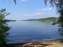
Havel at the "Great Window" in Berlin
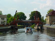
The Hast Bridge in Zehdenick
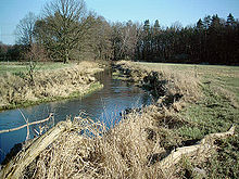
The Schnelle Havel, the non-navigable old Havel, at Schweitzerhütte north of Oranienburg-Friedrichsthal
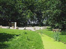
Havel spring at the Ankershagen mill lake in the Mecklenburg lake district
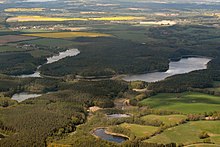
Havel spring area from the SE
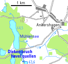
Havel spring near Ankershagen
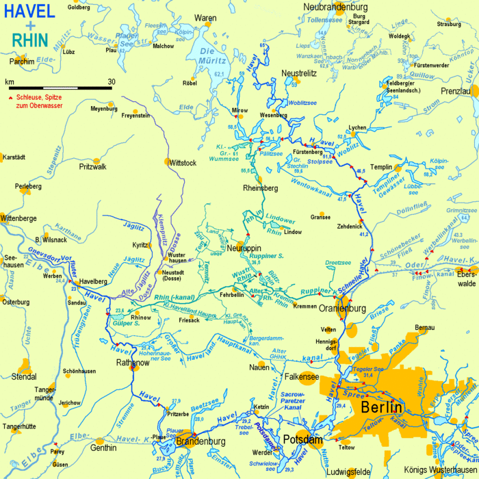
River courses and arms of the Havel (dark blue) and the Rhin (blue-green)
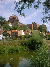
Havelberg: city moat (Havel arm) and cathedral
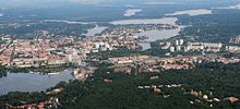
The Potsdam Havel in the Potsdam city centre
Search within the encyclopedia
