Havana (La Habana) — Cuba's capital city and historic port
Capital and largest city of Cuba, Havana is a historic Caribbean port noted for Spanish colonial architecture, vibrant music and culture, and its strategic role in maritime and political history.
Overview
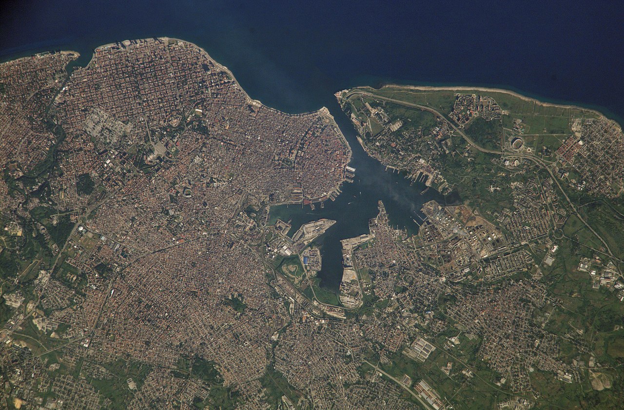
Havana (Spanish: La Habana) is the capital and largest city of the island nation of Cuba. It sits on the island's northwest coast with a long natural harbor that has shaped its development as the country's principal port, political center, and cultural hub. The city proper contained roughly 2.1 million residents in the early 2010s, and its metropolitan area is home to a substantial share of the national population.
Image gallery
10 Images


Geography and urban layout
Havana occupies a coastal plain and wraps around a wide bay. The city's historic core, often called Old Havana, fronts the harbor; surrounding districts include Centro Habana, Vedado, and Miramar, each with distinct characters. Havana lies across the Straits of Florida from the continental United States, with the nearest major U.S. outpost being Key West. Its tropical climate influences daily life, architecture, and the economy, particularly the tourism and waterfront activities that dominate the waterfront and promenades.
History
European settlement began in the early 16th century. Spanish navigators established a permanent presence in the region, and Havana grew rapidly because of its strategic position on transatlantic shipping routes. In the late 16th century the settlement received official urban status and defensive works were built to protect the harbor and the valuable convoys that gathered there. Over subsequent centuries the city has experienced colonial growth, economic shifts, and political change. A notable event in modern history was the 1898 explosion of the battleship Maine in Havana's harbor, an incident that precipitated the Spanish–American War and marked a turning point in Cuba's relationship with Spain and the United States.
Architecture, fortifications, and notable sites
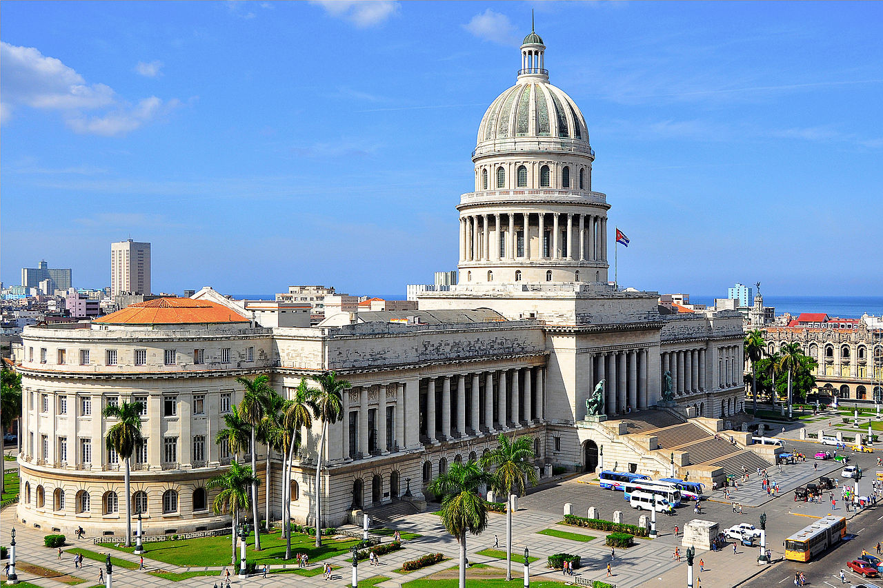
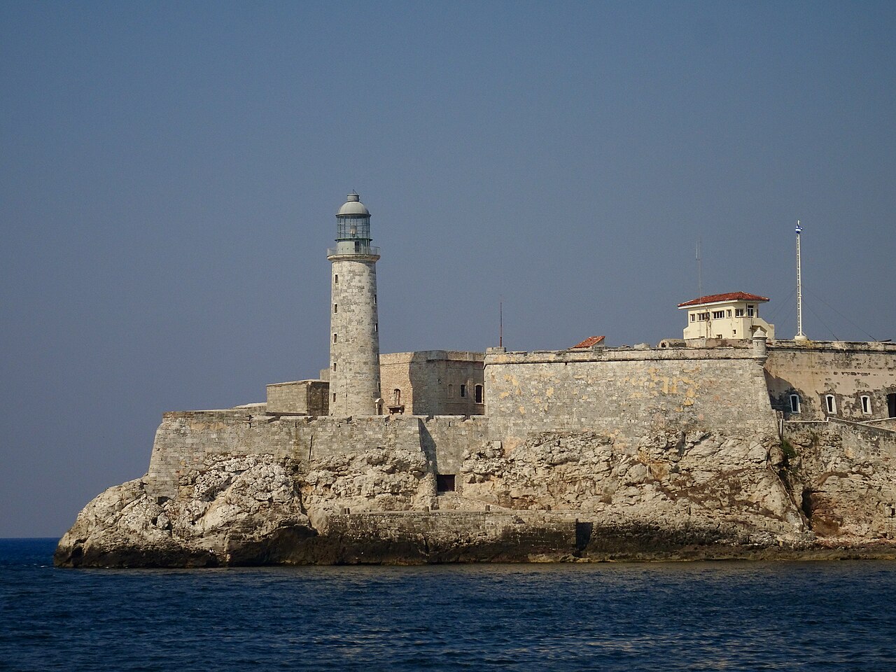
Havana's streets display a mixture of colonial, neoclassical, art deco, and mid-20th-century styles. The oldest section, La Habana Vieja, contains narrow streets, plaza-centered urban blocks, and many restored churches, civic buildings, and private houses whose conservation earned the district recognition as a UNESCO World Heritage Site for its historic center and fortifications. Prominent defensive structures include the Castillo de los Tres Reyes del Morro and other forts built to guard the harbor, as well as remnants of the old city walls.
- La Habana Vieja (Old Havana) — historic core and plazas
- El Malecón — the long seaside esplanade and social gathering place
- Castillo del Morro and La Cabaña — coastal fortresses
- Vedado and Miramar — diplomatic, residential and commercial districts
Culture, economy, and daily life
Havana is Cuba's foremost center for music, theater, visual arts, and higher education. The city is associated with Cuban musical styles such as son, salsa, and Afro-Cuban traditions that have international influence. Economically, Havana combines public administration with tourism, ports and shipping, light industry, and cultural enterprises; its seafront hotels, historic cafes and cigar ateliers attract visitors from around the world. Local life blends street markets, classical and popular music performances, and communal uses of public spaces.
Distinctions and contemporary relevance
Havana remains important as a symbol of Cuban national identity and as a living archive of colonial and 20th-century urban forms. Its preservation and ongoing restoration projects aim to balance heritage protection with modern needs. The city is frequently studied for its architecture, urban resilience, and the social role of cultural production. For travelers and scholars alike, Havana offers a compact example of Caribbean port-city history shaped by navigation, empire, revolution, and cultural creativity.

Name
The city of La Villa de San Cristóbal de La Habana was founded on 16 November 1519 at the behest of the Spanish king and Roman-German emperor Charles V. The name is composed of the name of the city's patron saint, San Cristóbal, and the name by which the settlement was formerly known: Habana. The inhabitants of Havana are called Habaneros.
There are several hypotheses about the origin of the name Habana. The most common of these is that the name can be traced back to a local Taíno chief named Habaguanex, who controlled the territories of the first settlement on the southern coast of what is now the province of Mayabeque.
Geography
Location
Havana is located on the northwestern coast of Cuba, south of the Florida Keys, where the Gulf of Mexico empties into the Caribbean Sea. The city extends primarily south and west of the bay, which divides the city into its three main ports: Marimelena, Guanabacoa, and Atarés. The Almendares River flows through the city from the south and joins the Florida Strait a few kilometers west of the bay.
The city sits on low hills that rise slightly above the strait. One of the highest points is a 60-meter-high limestone hill that extends from the east of the city to the colonial fortresses of La Cabaña and El Morro. Furthermore, in the western part of the city there is a slight elevation on the territory of the University of Havana. Outside the urban area, Havana is lined by higher hills to the west and east.
City breakdown
Havana is an independent Cuban province. Havana can be roughly divided into the inner-city districts of Old Havana (Habana Vieja), Centro Habana and Vedado, as well as the suburban districts. Havana's Old Town is a UNESCO World Heritage Site, here are also many tourist attractions such as the Plaza Vieja or the waterfront Malecón.
In the newer district of Vedado, located in the northwest of the city, numerous nightlife establishments and shopping facilities were developed, especially in the 20th century, which now rival those in the old city.
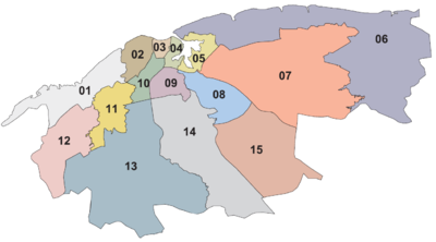
The city is divided into 15 municipalities (Municipios), which are themselves subdivided into 105 districts (Consejos populares):
- Playa: Santa Fe, Siboney, Cubanacán, Ampliación Almendares, Miramar, Sierra, Ceiba, Buena Vista.
- Plaza de la Revolución: El Carmelo, Vedado-Malecón, Rampa, Príncipe, Plaza, Nuevo Vedado-Puentes Grandes, Colón-Nuevo Vedado, Vedado.
- Centro Habana: Cayo Hueso, Pueblo Nuevo, Los Sitios, Dragones, Colón.
- La Habana Vieja : Prado, Catedral, Plaza Vieja, Belén, San Isidro, Jesús Maria, Tallapiedra.
- Regla : Guaicanimar, Loma Modelo, Casablanca.
- La Habana del Este : Camilo Cienfuegos, Cojimar, Guiteras, Alturas de Alamar, Alamar-Este, Guanabo, Campo Florido, Alamar-Playa.
- Guanabacoa : Mañana-Habana Nueva, Villa I, Villa II, Chivas-Roble, Debeche-Nalon, Hata-Naranjo, Peñalver-Bacuranao, Minas-Barreras.
- San Miguel del Padrón: Rocafort, Luyanó Moderno, Diezmero, San Francisco de Paula, Dolores-Veracruz, Jacomino.
- Diez de Octubre : Luyanó, Jesús del Monte, Lawton, Vista Alegre, Acosta, Sevillano, La Víbora, Santos Suárez, Tamarindo.
- Cerro: Latinoamericano, Pilar-Atares, Cerro, Las Cañas, El Canal, Palatino, Armada.
- Marianao : CAI-Los Ángeles, Pocito-Palmas, Zamora-Cocosolo, Libertad, Pogoloti-Belén-Finlay, Santa Felicia.
- La Lisa : Alturas de La Lisa, Balcón Arimao, Cano-Bello26-Valle Grande, Punta Brava, Arroyo Arenas, San Agustín, Versalles Coronela.
- Boyeros: Santiago de Las Vegas, Nuevo Santiago, Boyeros, Wajay, Calabazar, Altahabana-Capdevila, Armada-Aldabo.
- Arroyo Naranjo: Los Pinos, Poey, Víbora Park, Mantilla, Párraga, Calvario-Fraternidad, Guinera, Eléctrico, Managua, Callejas.
- Cotorro: San Pedro-Centro Cotorro, Santa Maria del Rosario, Lotería, Cuatro Caminos, Magdalena-Torriente, Alberro.
Climate
Havana, like most other areas of Cuba, has a tropical climate influenced by the northeast trade winds. According to the effective climate classification according to Köppen, Havana has a tropical savannah climate. Due to the Gulf Stream, there is also the influence of oceanic maritime climate. Average temperatures range from 22 degrees Celsius in January and February to 28 degrees Celsius in August. Havana rarely gets colder than 10 degrees Celsius, the lowest temperature ever recorded was 4.5 degrees Celsius in Santiago de Las Vegas on January 11, 1970. The highest temperature ever recorded was 36.6 degrees Celsius in Casablanca on September 10, 2009. Rainfall is heaviest between June and October, with the fewest rainy days between December and April. On average, Havana receives almost 1,200 mm of rainfall with about 80 days of rainfall per year. Although the hurricane season begins every year in Cuba in September, the city has rarely been hit by the storms, as they occur more frequently in the southeast of the island.
| Havana | ||||||||||||||||||||||||||||||||||||||||||||||||
| Climate diagram | ||||||||||||||||||||||||||||||||||||||||||||||||
| ||||||||||||||||||||||||||||||||||||||||||||||||
| Monthly average temperatures and precipitation for Havana
Source: wetterkontor.de | ||||||||||||||||||||||||||||||||||||||||||||||||||||||||||||||||||||||||||||||||||||||||||||||||||||||||||||||||||||||||||||||||||||||||||||||||||||||||||||||||||||||||||||||||||||||||||||||||||||||||||||||||||||||||||||||||||||||||||||||||||||||||||||||||||||||||||||||||||||||||||

Related articles
Author
AlegsaOnline.com Havana (La Habana) — Cuba's capital city and historic port Leandro Alegsa
URL: https://en.alegsaonline.com/art/42885
Sources
- lonelyplanet.com : "How Obama's US-Cuba deal could shape Havana's future" · web.archive.org
- one.cu : "2012 Official Census"