Angola
![]()
The title of this article is ambiguous. For other meanings, see Angola (disambiguation).
Template:Infobox State/Maintenance/NAME-German
Angola (German [aŋˈgoːla], Portuguese [ɐŋˈgɔlɐ]; called "Ngola" in Kimbundu, Umbundu and Kikongo) is a state in southwestern Africa. National holiday is November 11, the anniversary of independence gained in 1975. Angola borders Namibia, Zambia, the Republic of Congo, the Democratic Republic of Congo and the Atlantic Ocean - the exclave of Cabinda, which belongs to Angola, is located in the north between the Democratic Republic of Congo and the Republic of Congo on the Atlantic Ocean.
The name Angola derives from the title Ngola of the Kings of Ndongo, a vassal state of the historical Congo Empire located east of Luanda. The region around Luanda received this name in the 16th century from the first Portuguese sailors who landed on the coast there and erected a padrão, a stone cross as a sign of possession for the Portuguese king. The name was extended at the end of the 17th century to the region around Benguela, then in the 19th century to the then unceded territory whose colonial occupation was undertaken by Portugal.
Geography
→ Main article: Geography of Angola
Geographical location
The Republic of Angola lies between 4° 22′ and 18° 02′ south latitude, and 11° 41′ and 24° 05′ east longitude. The country is roughly divided into a narrow lowland along the Atlantic coast, rising towards the east, towards the interior, to form the Bié highlands: these make up most of Angola, are flat in the south and mountainous in the centre of the country. The highest mountain is Môco, located in this highland, at 2619 m above sea level. The east of Angola is crossed by the Zambezi River.
Climate
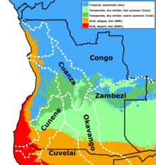
Angola is divided into three climatic zones:
On the coast and in the north of the country it is tropical, which means that there are high daytime temperatures between 25 and 30 °C all year round, and it is only slightly cooler at night. From November to April is the rainy season. The climate is strongly influenced by the cool Benguela Current (17-26 °C), so fog is common. The average rainfall is 500 mm, in the south barely 100 mm annually.
The highlands in the center and south of the country are temperate-tropical, there are significant temperature differences between day and night, especially in winter. In Huambo, for example, the temperatures in July are between 25 °C during the day and 7-8 °C at night, and there is also enormous drought. Similar to the coast, the rainy season is from October to April. On average, about 1000 mm of rain fall per year.
The southeast of the country is predominantly hot and dry with cool nights in winter or heat and occasional rainfall in summer. Annual precipitation varies around 250 mm.
Hydrology
The "water tower" of the country is the highlands of Bié. From there, Angola divides into 5 main catchment areas. The two largest are those of the Congo and the Zambezi. Together they drain over 40% of the country's land area. The areas drained by the Okavango are about 12 %. Thus, a good half of the country drains out of the country via very large catchment areas. In addition, there are the Cuanza, also with about 12 %, and the Cunene with just under 8 %. It is also worth mentioning the Cuvelai-Etosha catchment, which drains to the south. The remaining almost 20% of the country are coastal rivers. The water resources in the south of Angola are of great importance for the neighbouring countries Botswana and Namibia. For this reason, they jointly founded the Permanent Okavango River Basin Water Commission in 1994.
flora and fauna
Due to the climate, the vegetation ranges from tropical rainforest in the north and in Cabinda to tree savannahs in the centre and dry grass savannah interspersed with euphorbias (spurge plants), acacias and baobabs. Starting in Namibia, a desert strip runs along the southwest coast. Angola's fauna is rich in wildlife, with elephants, hippos, cheetahs, wildebeests, crocodiles, ostriches, rhinos and zebras. The expansion of agriculture but also the destruction caused by civil wars and the trade in ivory threaten the survival of many species.
Angola has 13 protected areas (national parks and nature reserves) with a total area of 162,642 km², representing 12.6% of the national territory.
See also: National parks in Angola

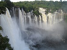
The Kalandula Falls

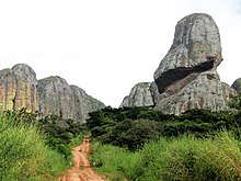
The Black Stones of Pungo Andongo in Malange

The climatic zones of Angola with the main catchment areas (dotted lines)
History
→ Main article: History of Angola
The first inhabitants of what is now Angola were Khoisan, who were largely displaced by Bantu peoples from the 13th century onwards. In 1483, Portuguese trading posts began to be established on the coast, mainly in Luanda and its hinterland, and a century later also in Benguela. It was not until the beginning of the 19th century that the systematic conquest and occupation of the present territory began, and was not completed until the mid-1920s.
From the mid-1920s to the early 1960s, Angola was subject to a "classical" colonial system. The colonial power Portugal was ruled by a military dictatorship from 1926 until the Carnation Revolution in 1974 (until 1932 Carmona, until 1968 Salazar, until 1974 Caetano).
Until the end of the colonial period, Angola's most important economic basis was agriculture and livestock breeding, which took place both on large farms run by European settlers and on family farms run by Africans. The mining of diamonds was central to the colonial state. Another important component was trade. Modest industrialization and development of the service sector did not occur until the late colonial phase, in the 1960s and 1970s. Oil deposits were located on the mainland in the 1950s and in the sea off Cabinda in the 1960s, but it was not until the very end of the colonial period that any major production took place.
In the 1950s, nationalist resistance began to form, culminating in an armed liberation struggle in 1961 (in 1960 - the "Africa Year" - 18 colonies in Africa (14 French, two British, one Belgian and one Italian) had gained independence from their colonial powers; see also Decolonization of Africa).
From 1962 onwards, Portugal therefore carried out drastic reforms and initiated a late colonial phase, which created a qualitatively new situation in Angola, but did not bring the war of independence to a halt. The war of independence came to an abrupt end when, on April 25, 1974, a military coup in Portugal triggered the Carnation Revolution and brought down the dictatorship there, and the new democratic regime immediately began decolonization.
The coup in Portugal triggered armed conflicts in Angola between the liberation movements FNLA, MPLA and UNITA, whose ethnic roots in the country were quite different. The USA, Zaire (since 1997 "Democratic Republic of Congo") and South Africa (still under the apartheid regime) intervened in these conflicts on the side of the FNLA and UNITA, the Soviet Union and Cuba on the side of the MPLA. The latter retained the upper hand and proclaimed independence in Luanda in 1975, at the same time FNLA and UNITA in Huambo.
The "counter-government" of FNLA and UNITA dissolved quickly, but immediately after the declaration of independence a civil war between the three movements began, from which the FNLA left after a short time, while UNITA continued it until the death of its leader Jonas Savimbi in 2002. At the same time, the MPLA established a political-economic regime modeled on that of the socialist countries of the time. Cuba's civilian development aid during this period was remarkable.
This regime was abandoned in 1990/91 during an interruption of the civil war in favour of a multi-party system. Elections were held in September 1992, in which UNITA also participated. The MPLA received 53.74 percent of the vote and 129 of the 220 parliamentary seats. The MPLA's presidential candidate, José Eduardo dos Santos, received 49.56 percent of the vote; under the constitution, a runoff (against Jonas Savimbi) would have been necessary.
This resulted in a bizarre situation that lasted until 2002. On the one hand, representatives of UNITA and the FNLA took part in parliament and even the government, while on the other hand the military arm of UNITA continued to fight after the election. The political system evolved into an authoritarian presidential democracy, while destruction of considerable proportions took place in the country.
On 22 February 2002, the army discovered Jonas Savimbi in the east of the country and shot him dead. After that, UNITA immediately stopped fighting. It disbanded its military arm, part of which was absorbed into the Angolan army. Under a new leader, Isaias Samakuva, it took on the role of a normal opposition party. In the September 2008 general election, the MPLA received 81.64% of the vote (UNITA 10.39%, FNLA 1.11%).
In 2002, the reconstruction of the destroyed cities, villages and infrastructures began. Thanks to oil production and the temporarily high oil price, there was enough foreign currency for this.
A new constitution adopted in January 2010 has strengthened the position of the MPLA and especially of the president. One can see in it an authoritarian presidential system.

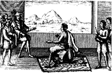
Queen Nzinga of Matamba negotiates with Portuguese colonial masters
Questions and Answers
Q: Where is Angola located?
A: Angola is located in southern Africa.
Q: Which countries border Angola?
A: Namibia borders Angola in the south, the Democratic Republic of the Congo borders Angola in the north, and Zambia borders Angola in the east.
Q: Which ocean does Angola's west border touch?
A: Angola's west border touches the Atlantic Ocean.
Q: What is the length of Angola's coastline?
A: Angola's coastline is 1600 kilometers long.
Q: What is Angola's capital?
A: Angola's capital is Luanda.
Q: What are some of Angola's natural resources?
A: Angola has many natural resources.
Q: Which organizations count Angola as a member state?
A: Angola is a member state of the African Union, the Community of Portuguese Language Countries, the Latin Union, South Atlantic Peace and Cooperation Zone and the Southern African Development Community.
Search within the encyclopedia