Hamburg — Free and Hanseatic City
Hamburg is a major German port city-state on the River Elbe, known for its maritime trade, Hanseatic heritage, cultural institutions and extensive waterways and green spaces.
Overview
Hamburg, officially the Free and Hanseatic City of Hamburg, is a major city and one of Germany's federal states. It sits on the tidal Elbe and functions as a national hub for shipping, logistics, media and culture. The wider city has roughly 1.85 million residents and covers an area of about 755 km². Its status as a historic trading center is reflected in the official name and in the urban fabric of warehouses, canals and port infrastructure.
Image gallery
8 Images


Geography and urban character
Located in the north of the country, Hamburg lies upstream from the North Sea and is linked to the ocean by the Elbe. The built area is interwoven with rivers, lakes and canals: the Binnenalster and Außenalster lakes are prominent central features. Large parks, wetlands and suburban districts surround a dense inner city of commercial quarters, residential neighborhoods and industrial waterfronts. The port area remains active alongside restored warehouse districts and modern developments.
History and identity
Hamburg's roots go back to a medieval trading settlement; it became a prominent member of the Hanseatic League and long retained civic independence and commercial privileges. That mercantile legacy shaped its architecture and institutions. The city suffered extensive damage from aerial bombing during the Second World War and underwent large-scale reconstruction and redevelopment in the postwar era. In recent decades it has invested in prominent cultural projects and waterfront regeneration.
Economy, transport and the port
The Port of Hamburg is central to the city's economy: container terminals, bulk and break-bulk facilities and logistics operations make it one of Europe's busiest sea harbors. Hamburg is also a national center for media, aviation suppliers, finance and creative industries. Well-developed rail, road and inland-waterway links connect the city to national and international networks, while an international airport and extensive public transit serve daily commuters and visitors.
Culture, landmarks and society
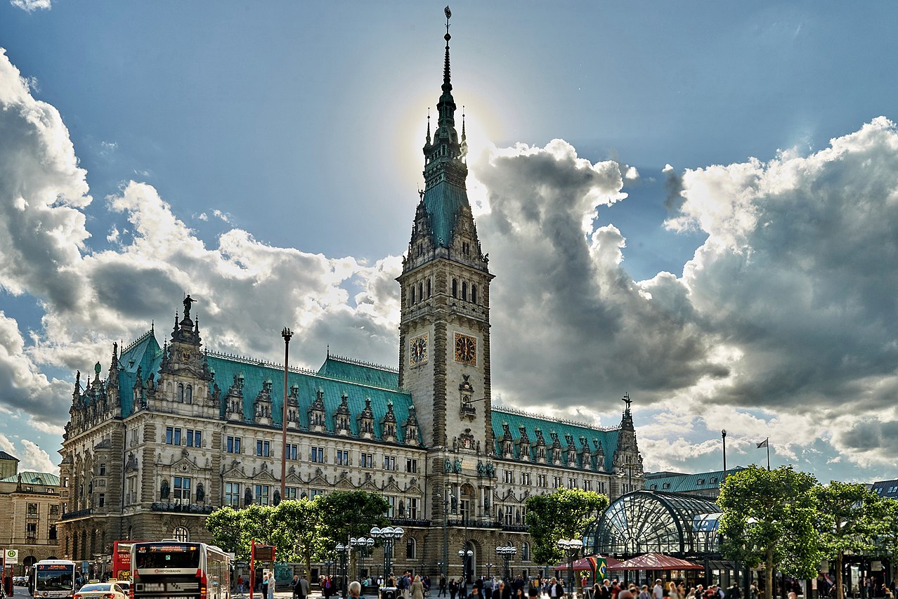
Hamburg combines historic quarters and contemporary culture. Notable sites include the Speicherstadt warehouse district and the Elbphilharmonie concert hall, alongside long-established theaters, museums and a vibrant music scene. The Reeperbahn nightlife district and maritime festivals reflect both local tradition and international influences. Religious affiliation in the population is diverse, with Protestant and Catholic communities, various faith groups and a substantial share of residents who identify as non‑religious.
Government, climate and notable facts
As a city-state, Hamburg has its own government and parliament and handles both municipal and state responsibilities. The climate is temperate oceanic (Köppen Cfb), with mild winters and relatively cool summers influenced by maritime air. The city's combination of waterways, bridges, and green areas gives it a distinctive layout and makes waterborne commerce and leisure visible throughout urban life.
Selected landmarks and features
- Speicherstadt and Kontorhaus quarters (historic warehouses and offices)
- Elbphilharmonie concert hall and harbourfront promenades
- St. Michael's Church and other historic churches
- Alster lakes and extensive public parks
- Reeperbahn and cultural districts for nightlife and music
Related links and references
For more detailed information see related entries and resources: German name, city, north, Germany, Elbe, River Elbe, North Sea, states, population, 1.85 million, Berlin, EU ranking, Hanseatic League, Lübeck, Rostock, Wismar, Stralsund, Bremen, Greifswald, Demmin, World War II bombing, area, 755.16 km2, 291.6 sq mi, oceanic climate.
Geography
Location
Hamburg is located in northern Germany at the mouths of the Bille and Alster rivers into the Lower Elbe, which flows into the North Sea about 100 kilometers further northwest. Near this estuary is the district of Neuwerk, which consists of three islands. On the Elbe, the tidal harbor extends roughly from Veddel to Finkenwerder, mainly on the southern bank of the Norderelbe, opposite the districts of St. Pauli and Altona. The two banks are connected by the Elbe bridges to the east and by the Old and New Elbe Tunnels. The land south and north of the river is Geest, higher land formed by the sand and debris deposits of glaciers during the ice ages. The northernmost areas of the city are part of the fertile young moraine land. For centuries, the marshes immediately adjacent to the river on both sides of the Elbe were traversed by tributaries of the Elbe and inundated by floodwaters from the North Sea, depositing sand and silt. In the meantime, the Elbe has been diked on both sides, and tributaries have been drained, diverted, canalized or drained. Old dikes in the outlying villages are a reminder of the time when entire neighborhoods were flooded during high tides. The highest elevation is 116.2 meters above sea level, the Hasselbrack in a northern foothill of the Harburg Mountains.
The Alster in the city center has been dammed up into a lake since the Middle Ages. This is divided into the larger Außenalster and the smaller Binnenalster, which is enclosed by the historic core of the city. The tributaries of the Alster - like the Alster itself - are partly canalized in the city area. They are mostly lined by extensive public parks. The numerous canals, rivers and canals of the city are spanned by almost 2500 bridges. It is widely unknown that one of the last tidal floodplain forests in Europe is located on the largest river island of the Elbe, in Wilhelmsburg.
Hamburg borders Schleswig-Holstein to the north and Lower Saxony to the south. Apart from a few minor "territorial adjustments", such as the acquisition of the island of Neuwerk and parcels of land at the Geesthacht dam, the current boundaries of the city of Hamburg have existed since the Greater Hamburg Act, which came into force on April 1, 1937. The city is the second largest city in Germany after Berlin, both in terms of population and area.
South of the Binnenalster lies the historic center of the city. The geographic center of Hamburg in its current political boundaries is said to be a point on the Kuhmühlenteich in the Uhlenhorst district. The northernmost point of Hamburg is the island of Scharhörn, the easternmost is Altengamme, the southernmost is Krauel and the westernmost is the island of Nigehörn. The largest extension of the city in the east-west direction is 39.88 km and in the north-south direction 42.31 km.
Running waters
- Elbe (Lower Elbe) with Norderelbe, Süderelbe, Köhlbrand, Reiherstieg, Rethe, Dove Elbe and Gose Elbe
- Tributaries of the Elbe: Seevekanal, Bille, Alster, Flottbek and Este
- Tributaries of the Alster: Eilbek (Wandse), Osterbek, Goldbek, Isebek, Tarpenbek, Saselbek, Rodenbek, Bredenbek, Ammersbek
See also: List of surveys in Hamburg
Protected areas
See also: List of natural monuments in Hamburg and List of nature reserves in Hamburg.
See also: List of Landscape Protection Areas in Hamburg and List of Water Protection Areas in Hamburg
Geology
→ Main article: Hamburg's geological subsurface
Management structure
Districts
→ Main article: Districts in Hamburg
Hamburg's state constitution stipulates that districts are to be formed in which district offices are responsible for the independent execution of assigned tasks. The seven boroughs are divided into a total of 104 districts. Most districts are further subdivided into several local districts, 181 in total since January 1, 2011. Some districts in the core area of the boroughs were administered directly by the relevant district office until 2008, while the other districts in the boroughs each had their own local office; a total of 13 local offices were established. At the beginning of 2008, a territorial reform redrew the boundaries of individual city districts and boroughs. Thus, the district of Wilhelmsburg fell from the district of Harburg to Mitte, and the districts of Sternschanze in the district of Altona and HafenCity in the district of Hamburg-Mitte were newly created.
| List of Hamburg districts (data as of December 31, 2018) | |||||
| No. | District | Inhabitants | Surface area | Area sharein | Inhabitants per |
| 1 |
| 302.994 | 142,2 | 18,8 | 2.130 |
| 2 |
| 274.702 | 077,9 | 10,3 | 3.526 |
| 3 |
| 264.869 | 049,8 | 06,6 | 5.318 |
| 4 |
| 313.617 | 057,8 | 07,7 | 5.429 |
| 5 |
| 438.624 | 147,5 | 19,5 | 2.973 |
| 6 |
| 129.599 | 154,8 | 20,5 | 0.838 |
| 7 |
| 167.405 | 125,2 | 16,6 | 1.338 |
|
| 1.891.8100. | 755,2 | 100,00 | 2.505 | |
Exclaves
Hamburg includes the North Sea islands of Neuwerk, Scharhörn and Nigehörn, as well as the Hamburg Wadden Sea National Park, which was added to the North Sea Wadden Sea World Heritage Site in 2011. As the district of Hamburg-Neuwerk, they belong to the district of Hamburg-Mitte, which is therefore the northernmost and westernmost district of Hamburg. Volksdorfer Buschwiese is a Hamburg exclave completely enclosed by the territory of the municipality of Ammersbek in Schleswig-Holstein and belongs to the district of Wandsbek.
Neighboring cities and municipalities
The following cities and municipalities border the city of Hamburg; they are named clockwise starting in the northwest:
- in Schleswig-Holstein:
- in the district of Pinneberg (PI): Wedel, Appen, Pinneberg, Schenefeld, Halstenbek, Rellingen, Ellerbek (Amt Pinnau) and Bönningstedt
- in the district of Segeberg (SE): Norderstedt
- in the district of Stormarn (OD): Tangstedt (Stormarn), Jersbek (Amt Bargteheide-Land), Ammersbek, Ahrensburg, Stapelfeld (Amt Siek), Barsbüttel, Oststeinbek, Glinde and Reinbek
- in the Duchy of Lauenburg County (RZ): Wentorf bei Hamburg, Börnsen and Escheburg (both in the Hohe Elbgeest district) and Geesthacht
- in Lower Saxony:
- in the district of Harburg (WL): Drage (joint municipality of Elbmarsch), Winsen (Luhe), Stelle, Seevetal, Rosengarten and Neu Wulmstorf
- in the district of Stade (STD): Jork
- in the district of Cuxhaven (CUX): Cuxhaven (mainland near Neuwerk)
Climate
See also: List of climate data at Hamburg Airport and Climate Change section on this page.
Hamburg is located in the cool temperate climate zone and is characterized by a maritime climate. Due to the maritime influences caused by prevailing westerly winds, the climate is milder in winter and cooler in summer than in the eastern hinterland.
The average annual temperature is 9.4 °C. The warmest month is July with an average of 18.1 °C, the coldest is January with 1.6 °C. Temperatures around 28 °C are not uncommon in midsummer. A maximum value of 37.3 °C (August 9, 1992) was measured at the Hamburg-Fuhlsbüttel weather station. The absolute minimum temperature is -29.1 °C (February 13, 1940). The climate is humid all year round. In the course of a year, precipitation averages 773 mm, and fog prevails on an average of 52 days a year. The most rain falls in the 31 days around June 29; the least falls around April 16. In the winter months, it can get very stormy. Hamburg's dirty weather is proverbial.
| Hamburg | ||||||||||||||||||||||||||||||||||||||||||||||||
| Climate diagram | ||||||||||||||||||||||||||||||||||||||||||||||||
| ||||||||||||||||||||||||||||||||||||||||||||||||
| Monthly average temperatures and precipitation for Hamburg
Source: German Weather Service | ||||||||||||||||||||||||||||||||||||||||||||||||||||||||||||||||||||||||||||||||||||||||||||||||||||||||||||||||||||||||||||||||||||||||||||||||||||||||||||||||||||||||||||||||||||||||||||||||||||||||||||||||||||||||||||||||||||||||||||||||||||||||||||
Environment
The environmental situation is and has often been the subject of heated debate in Hamburg. The noise pollution caused by road, rail and air traffic, which endangers the health of many residents, is a regular topic of discussion. Despite a high share of motor vehicles in the trips made by residents and a high volume of commuting, which also takes place to a considerable extent by car, Hamburg does not have an environmental zone, unlike most other German conurbations. As far as air pollution is concerned, in addition to the pollution from heating, power generation, three waste incineration plants and car traffic typical of large cities, there is further pollution from port-related shipping traffic and industry, here also with odor nuisance.
Hamburg has had an authority with "Environment" in its name since 1978. It successfully applied for the title of European Environmental Capital on behalf of the city, which Hamburg was allowed to use in 2011, a move that was criticized by environmental associations.
Nature Conservation
There were debates in the early 2000s about the expansion at Airbus and, in connection with this, the partial filling of the Mühlenberger Loch and, until 2008, about the construction of the new Moorburg coal-fired power plant. Environmental scandals such as the dioxin contamination of the Boehringer site in Billbrook and the toxic mountain with dioxin and parathion in Georgswerder in the early 1980s as well as the problems with contaminated or toxic Elbe silt, among others in Altenwerder, have become known nationwide. In addition, the deepening of the Elbe is a point of contention in Hamburg politics.
Air
Until the year 2000, air pollution with NO2 decreased steadily. This was attributed to the mandatory introduction of the catalytic converter and the renewal of the motor vehicle fleet. Since then, pollution has remained at the level achieved or has risen again at some stations. Due to the exceeding of the NO2 limits, an air pollution control plan was adopted for the first time in 2004, which included measures to ensure compliance with the NO2 limits in the long term.
However, the persistent exceedance of NO2 limits made it necessary to update Hamburg's clean air plan in 2012. In addition, the number of 35 exceedances of the daily mean limit value for particulate matter (PM10) permitted per calendar year was not met for the first time in 2005 and 2006. The 1st update of the Hamburg Clean Air Plan therefore contains various measures to reduce the pollutants NO2 and particulate matter.
Due to persistent limit value exceedances for nitrogen dioxide, the city was obliged by a ruling of the Administrative Court of Hamburg of November 5, 2014 (9 K 1280/13) to "amend the currently valid Clean Air Plan in such a way that it contains the measures required to comply as quickly as possible with the immission value for NO2 of 40 μg/m³ averaged over a calendar year." The 2nd update of the Clean Air Plan (which came into force on June 30, 2017) also serves in particular to implement this ruling.
Climate change
In Hamburg, global warming leads to a greater number of summer days, hot days and tropical nights, which has implications for labor productivity, concentration levels and the health of the city's population. The even greater decrease in frost and ice days, which are important for agriculture, has less relevance for Hamburg as a city. With regard to the development of precipitation amounts, no sufficient data are available so far. The rise in sea level will lead to an increased risk of storm surges and more sediments and a shift of the brackish water zone in the Elbe.
The city administration monitors these consequences of climate change on the basis of a "climate plan" in order to assess them and take adaptation measures.


History
![]()
This article or section needs revision. More details should be given on the discussion page. Please help improve it, and then remove this marker.
→ Main article: History of Hamburg
The oldest permanent dwellings date back to the 4th century BC for the village, which was still called Treva by the ancient scientist Claudius Ptolemy. From the 4th to the 6th century Saxons settled in the North Elbe area.
In the 8th century, Hammaburg Castle was built, where Charlemagne had a baptistery erected in 810 to proselytize the pagan north. In 831, Louis the Pious founded a bishopric here, which became an archbishopric a short time later. However, shortly after the division of the empire at Verdun in 843, Vikings raided the region, later the Slavic Abodrites, and the archbishop moved his official residence to Bremen.
Count Adolf III of Schauenburg and Holstein was the founder of a trading and market settlement on the western bank of the Alster in the 12th century. As a result of the port rights allegedly granted to this settlement by Emperor Frederick I Barbarossa in 1189 and the trading privileges for the entire Lower Elbe, the city developed into a flourishing trading center in the Middle Ages and, with its 600 breweries at times, was regarded as the "brewing house of the Hanseatic League". In the 14th century, Hamburg, as one of the first members of the Hanseatic League of Merchants, developed into the most important German transhipment and stacking point between the North Sea and the Baltic. From 1510 Hamburg was finally considered an imperial city. In 1558, the Hamburg Stock Exchange was opened as one of the first in Germany, and in 1678, the first German opera house was opened on Gänsemarkt under the name of Opern-Theatrum. At the time of the Reformation, the city-state became Protestant without bloodshed. The city of Hamburg experienced its cultural heyday primarily in the 17th and 18th centuries with, among other things, the founding of the Hamburg National Theater (1767).
Even after the decline of the Hanseatic League and during the Enlightenment and industrialization, the city remained the most important economic center in northern Germany alongside Berlin. Hamburg was spared the effects of the Thirty Years' War and was able to use it to its advantage to expand its supremacy in trade. In its eventful history, the city was subject to the Danish royal crown (but never formally recognized by Hamburg), was part of the Holy Roman Empire of the German Nation, and was the capital of the Département des Bouches de l'Elbe (Elbe estuary department) in the French Empire (Hamburg French period). In 1813-1814 Hamburg was besieged by the Russian general Bennigsen. As a free city, it joined the German Confederation in 1815 after the Congress of Vienna. In 1867 it became a member of the North German Confederation initiated by Otto von Bismarck and in 1871 remained a member state of the federal state now renamed the German Empire.
Special events in modern times were the Great Hamburg Fire of 1842, the cholera epidemic of 1892, the considerable increase in area and population in 1937/38 as a result of the Greater Hamburg Act, the bombings in World War II in 1943, the destruction of the Jewish community (→ History of the Jews in Hamburg), the establishment of the Neuengamme concentration camp and its numerous subcamps in the city area, the surrender to the British troops without a fight on May 3. May 1945, the storm surge in 1962, the connection to the international road network and air traffic (Finkenwerder and Fuhlsbüttel), the changes in the port and the disputes over Hafenstrasse in the 1980s.
Hamburg's policy has always been to maximize the freedom of its trade and political independence. Today, Hamburg is still largely independent as a city-state and offers good conditions for trade with Germany's largest seaport.

Related articles
Author
AlegsaOnline.com Hamburg — Free and Hanseatic City Leandro Alegsa
URL: https://en.alegsaonline.com/art/42010
Sources
- commons.wikimedia.org : Hamburg
- en.wikivoyage.org : Hamburg
- statistik-nord.de : "State population"
- vgrdl.de : "Bruttoinlandsprodukt – in jeweiligen Preisen – in Deutschland 1991 bis 2016 nach Bundesländern (WZ 2008) – VGR dL"
- ec.europa.eu : ec.europa.eu/eurostat/documents/2995521/7192292/1-26022016-AP-EN.pdf/602b34e8-abba-439e-b…
- mercer.com : "Vienna tops Mercer's 19th Quality of Living ranking"
- internetagentur-seo-hamburg.de : "Internetagentur Hamburg"
- hamburg-economy.de : hamburg-economy.de/res/downloads/wirtschaftsstandort_hh.pdf