Hadrian's Wall: Roman frontier across northern Britain
A concise encyclopedia article on Hadrian's Wall: its construction, form, function, later history and significance as part of the Roman frontiers World Heritage listing.
Hadrian's Wall is the most prominent Roman frontier monument in Britain, stretching across what is now northern England. Erected under the emperor Hadrian in the early decades of the 2nd century, it marked a deliberate limit to the Roman Empire's control in northern Great Britain. The feature combined masonry and earthwork construction: much of it comprised stonework while long western sections were built of turf. Its route ran roughly from the Solway Firth and the River Tyne coastlines and lay within what is today England.
Image gallery
10 Images


Overview and purpose
Work on the wall began around the reign of Hadrian in the early second century, typically dated to c. 122–126 AD in many accounts. Commissioned by the emperor and overseen locally by the provincial governor, the project was carried out by Roman legions stationed in Roman Britain. The structure functioned as a controlled frontier: a physical fortification that helped regulate movement, trade and military access between Roman territory to the south and the non‑Roman tribes to the north. In Roman terms it defined the northern border of their authority on the island for much of the 2nd century.
Design, materials and ancillary works
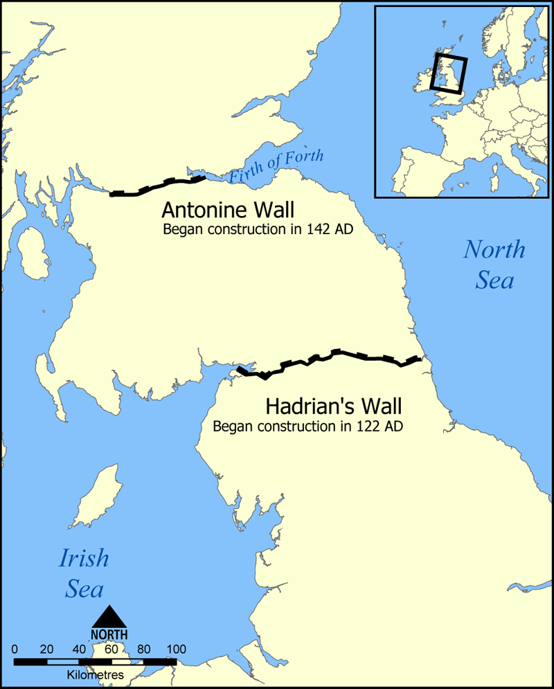
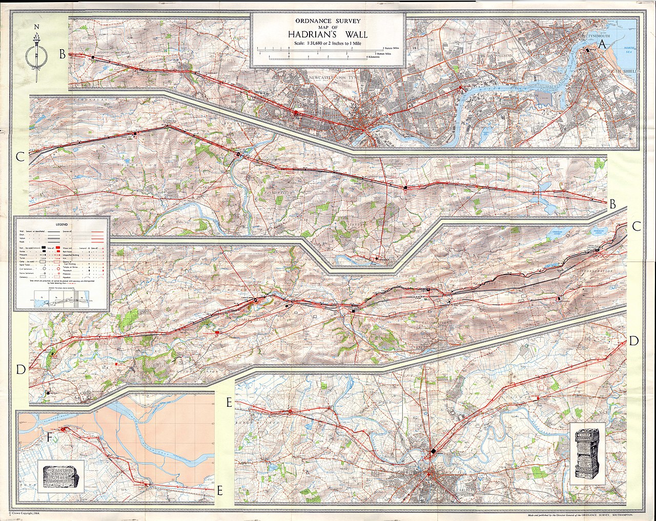
The wall varied along its length. In many places the surviving masonry measures several metres across and rises to a height that is visible today; other stretches were originally formed from piled and turfed earth. A substantial defensive ditch lay to the north of the wall and an accompanying southern earthwork known as the Vallum ran parallel to the main barrier. Regularly spaced forts, smaller fortlets and watch towers provided garrison points and observation posts, while gateways and roads allowed controlled transit. The eastern end was originally fixed near Newcastle upon Tyne and was later extended eastward in stone to the coast at Wallsend.
Military and civil functions
The wall served mixed military and administrative purposes. Garrisons in the larger forts housed detachments of legions and auxiliary units who patrolled the frontier, maintained signals and managed customs or toll points. Milecastles (small fortified gateways) and intervening turrets gave local control over crossing points and fields of observation. Beyond defence, the presence of the wall structured local economies: markets, supply chains and the stationing of troops stimulated settlement and the exchange of goods across the frontier.
Later history, archaeology and conservation
Although its practical military use waned over time, Hadrian's Wall remained a visible landmark through later centuries. It has been quarried for building stone in medieval and post‑medieval periods, and archaeological investigation since the 18th century has clarified its form and chronology. In 1987 the monument was inscribed by UNESCO as part of the World Heritage Site listing called the Frontiers of the Roman Empire, a transnational designation that also includes the Antonine Wall in Scotland and continental frontiers. Conservation today balances preserving visible masonry and earthworks with public access and interpretation.
Notable features and legacy
Hadrian's Wall remains widely studied and visited. Important components include a chain of well‑preserved forts, numerous milecastles and turrets, and the associated Vallum earthwork to the south. Its course and remains are documented in maps, museum collections and walking routes that attract both scholars and tourists. The wall is therefore a key source for understanding Roman military architecture, frontier administration and Roman interaction with the peoples of Britain; it also occupies a prominent place in Britain’s cultural and heritage landscape.
- Key elements: stone curtain wall, turf sections, ditch, forts and milecastles.
- Geography: crosses northern England from Solway Firth and the River Tyne.
- Historical context: construction under Hadrian in the early second century as part of Roman frontier strategy in northern Great Britain.
- Recognition: included in the World Heritage Site by UNESCO and considered alongside the Antonine Wall and other imperial frontiers.
For introductory reading and maps, museum sites and local authorities provide accessible summaries and visitor information; academic works and archaeological reports give detailed treatments of construction phases, garrison evidence and landscape context. Hadrian's Wall therefore continues to be both a subject of rigorous research and a widely appreciated historic route across the British landscape.


Location and topography
The Wall Zone was located on the territory of the Roman province of Britannia inferior, after the division in late antiquity on the territory of the province of Maxima Caesariensis, which included the whole of northern Britain.
As far as Wallsend, the Tyne estuary formed a natural boundary to the east coast. The wall extended for 117.5 kilometres (78 Roman miles), starting in the east at Segedunum, from the north bank of the Tyne eight kilometres overland to the fort of Pons Aelius (now Newcastle upon Tyne), Condercum (now Benwell), Coriosopidum (now Corbridge), Luguvalium (now Carlisle), to name but a few, to the westernmost fort of Maia (now Bowness-on-Solway), where it ended at the Solway Firth. This is a fjord which opens out to the Irish Sea after 30 km. After Bowness-on-Solway the fortifications continued along the west coast of Cumbria, reinforced by a series of small forts and towers - south to Maryport. All these sites lie to the north of a once important Roman military road and boundary marker, known as Stanegate between Carlisle and Corbridge, which there intersected with Dere Street leading to Scotland. The rampart closes the isthmus between the mouth of the Tyne and the Solway Firth, and connects across the central hill country of the Pennines, the mountains in the west of the island with the eastern heights. The Wall terrain averages 150 metres above sea level, reaching its highest elevation (680 metres) at the Whin Sill's. This area has been intensively farmed since before the Romans arrived. The isthmus was ideal for the construction of a barrier, partly because this region of Britain lacks natural boundary markers - such as rivers.
History
The route on the northern side of the river valleys of Tyne, Irthing and Eden was already known to the Romans since the campaigns of Agricola in the 1st century. The Stanegate military road, secured by forts and watchtowers, also ran along the valley floor there, marking the northern border in Britain from AD 105. Unlike the Stanegate road, which essentially followed the valleys, Hadrian's Wall ran as far as possible along the ridges of the hills. From the east the rampart stretched from Wallsend to Chesters and from there began to ascend via its northernmost point, Limestone Corner, to the impressive basalt cliffs of the Whin Sills, from where there are good views of the surrounding countryside. These, a 20-metre-high lagoon of volcanic rock, then drop steeply to what are known as the Craigs. At Willowford the rampart crosses the Irthing and now keeps closely to its north bank. West of Carlisle the Wall finally reaches the marshes of the Solway, where it runs between Burgh-by-Sands and Bowness-on-Solway on a line just above the high-water mark. From Bowness onwards the boundary defences continued along the Cumbrian coast.
Questions and answers
Q: What is Hadrian's Wall?
A: Hadrian's Wall is a stone and turf fortification built across northern Great Britain by the Roman Empire in the early second century. It was built to control barbarians, specifically the ancient Britons to the north of the wall.
Q: How long was Hadrian's Wall?
A: The wall was about 118 kilometres (73 miles) long. Most of the wall – 67 kilometres (42 miles) – was made of stone, and for 46 kilometres (29 miles) it was made of turf.
Q: How thick and tall were parts of Hadrian's Wall?
A: The stone part of the wall was 3 metres (9.8 feet) thick and about 4.2 metres (14 feet) tall, while the turf part was 6 metres (20 feet) thick and also about 4.2 metres (14 feet) tall.
Q: Where did Hadrian's Wall start and end?
A: The east end of Hadrian's Wall originally started at Newcastle upon Tyne, but later on more stone wall was added for an additional 6 kilometres (3.7 miles), ending at Wallsend on Tyne.
Q: What other features were associated with Hadrian's Wall?
A: In front of the wall there was a ditch that ran parallel to it which measured 3 metres deep and 8.2 metres wide, as well as small watch towers/fortes along its length known as Vallum which ran from coast to coast south of the wall itself.
Q: When did Romans use this structure?
A: The Romans used this structure for at least two hundred years until their departure from Britain in 410 AD when they abandoned all their fortifications in Britain including Hadrian’s Wall .
Q: When did UNESCO list it as a World Heritage Site?
A:Hadrian’s Wall became a UNESCO World Heritage Site in 1987 where it shares its listing with Antonine Walls in Scotland and German fortifications known as Limes Germanicus
Related articles
Author
AlegsaOnline.com Hadrian's Wall: Roman frontier across northern Britain Leandro Alegsa
URL: https://en.alegsaonline.com/art/41724
Sources
- whc.unesco.org : "Frontiers of the Roman Empire"
- english-heritage.org.uk : English Heritage. An archaeological map of Hadrian's Wall
- english-heritage.org.uk : english-heritage.org.uk/publications/hadrians-wall1/