Gumti River (tributary of the Meghna in Tripura and Bangladesh)
A hill‑fed river rising in the Dumbur area of Tripura, flowing into Bangladesh as a tributary of the Meghna system. Noted for strong seasonal flows, frequent flash floods, local navigation and ecological importance.
The Gumti River is a hill‑fed watercourse that rises in the Dumbur area of the northeastern hills of Tripura (India) and descends into the plains of Bangladesh, where it forms part of the Meghna river system. It is an important regional river for communities in both Tripura and the Bangladeshi districts it traverses, shaping local landscapes, livelihoods and seasonal wetland systems.
Image gallery
7 Images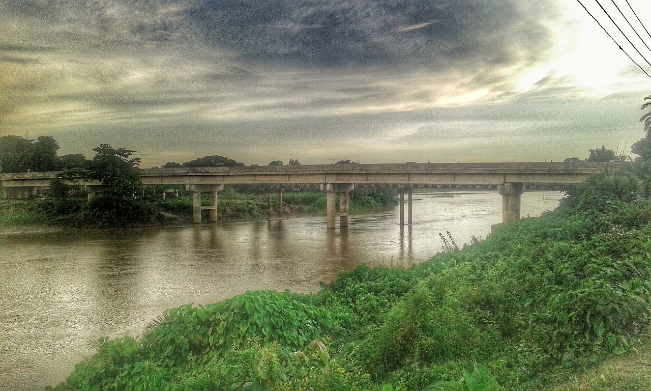


Physical characteristics
In its upper reaches the Gumti behaves as a typical upland or hilly river: it has a relatively steep gradient, a narrow channel compared with lowland rivers, and a strong current during rains. Seasonal variation is large. Observations at Comilla indicate that discharge can vary widely, with reported flows ranging from a few hundred cubic feet per second in dry periods to several thousands in flood. During the monsoon the channel commonly fills from bank to bank and broadens in many stretches; in winter the flow shrinks, exposing bars and making the river fordable at several local points.
Hydrology and floods
Rapid runoff from the Tripura hills and concentrated monsoon rainfall make the Gumti prone to sudden rises in water level. Flash floods are a frequent phenomenon, particularly following intense or prolonged upstream rain. In a typical year the river can rise more than a metre above surrounding floodplain levels during high water, inundating low‑lying agricultural land and riverside settlements. Bank erosion, channel migration and sedimentation occur where flows are energetic and riverbanks are exposed or cleared of vegetation.
Ecology and biodiversity
The Gumti supports aquatic and riparian habitats characteristic of hill‑fed tropical rivers. Seasonal connection between the main channel and adjacent floodplain wetlands creates productive feeding and breeding grounds for freshwater fish and other aquatic fauna. Floodplain grasses and wetlands also attract waterbirds and provide grazing at certain times of year. Vegetation along banks helps stabilize soil and sustain insects and small mammals that form part of the riverine food web.
Human use and economy
People living along the Gumti depend on it for multiple purposes: small‑boat transport and local navigation during the wetter months; capture fisheries that supply food and income seasonally; irrigation of nearby rice fields; and in some places extraction of sand and gravel for local construction. Floodplain agriculture, especially paddy cultivation on fertile flood‑deposited soils, is an important livelihood supported by the river’s seasonal dynamics.
Management, hazards and adaptation
Local authorities and communities contend with flood risk through a mix of measures: local embankments and raised homesteads, community early‑warning practices, designated flood shelters and ad hoc river training works where feasible. Land‑use changes in the watershed — including deforestation, intensive cultivation and settlement expansion upstream — can increase runoff and erosion, potentially contributing to higher and more abrupt flood peaks downstream. Because the river flows across an international border, rainfall and land‑use upstream in Tripura have direct implications for downstream conditions in Bangladesh.
Navigation and infrastructure
The Gumti is generally navigable by small boats during and shortly after the rainy season when flows and depths increase. In the dry season navigation is limited by low water and exposed sandbars. Bridges, culverts and small causeways built across the river influence local flow patterns and may affect sediment deposition and bank stability. Infrastructure planning in the basin seeks to balance access needs with flood safety and ecological considerations.
Names and distinctions
- The Gumti discussed here is distinct from similarly named rivers elsewhere in South Asia; it should not be confused with the Gomti River of northern India (Uttar Pradesh).
- Because of its upland origin the Gumti displays sharper seasonal swings and a more rapid current in flood than many lowland rivers in the region.
Overall, the Gumti River plays a significant role in local hydrology, ecology and human livelihoods. Its seasonal dynamism provides both benefits—such as fertile floodplain soils and fisheries—and hazards in the form of frequent flash floods. Sustainable management in the basin requires attention to upstream land use, community preparedness, and measures that support both livelihoods and ecological functioning.
Questions and answers
Q: Where does the Gumti River originate from?
A: The Gumti River originates from Dumbur in the northeastern hilly region of the Tripura Division.
Q: What is the Gumti River known for?
A: The Gumti River is known for being a hilly river with a strong current.
Q: How much does the flow of the Gumti River vary?
A: The flow of the Gumti River varies from 100 to 20,000ft³/s at Comilla.
Q: What is the average breadth of the Gumti River during the rains?
A: During the rains, the Gumti River's average breadth is about 100m.
Q: When does the Gumti River become fordable at most places?
A: The Gumti River becomes fordable at most places during the winter.
Q: What is the usual rise of the Gumti River in a year of normal rainfall?
A: In a year of normal rainfall, the Gumti River rises to above 1.5m than the level of the surrounding areas.
Q: How often do flash floods occur in the Gumti River?
A: Flash floods are common phenomena of the Gumti River and it occurs at frequent intervals.
Related articles
Author
AlegsaOnline.com Gumti River (tributary of the Meghna in Tripura and Bangladesh) Leandro Alegsa
URL: https://en.alegsaonline.com/art/41413