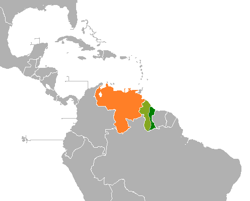
Guayana Esequiba: disputed western region of Guyana claimed by Venezuela
Guayana Esequiba is a 159,500 km² territory west of the Essequibo River administered by Guyana but claimed by Venezuela. The dispute arose from colonial-era claims, an 1899 arbitration and later UN-mediated diplomacy.
Overview
Guayana Esequiba (Spanish: Guayana Esequiba) is the name used by the Bolivarian Republic of Venezuela to refer to a large territory administered by the Cooperative Republic of Guyana. The area commonly identified with this name covers about 159,500 square kilometres and lies west of the Essequibo River. Venezuela regards the territory as subject to its historical and legal claims, while Guyana administers the territory as part of its national domain. The disagreement is rooted in colonial-era boundary assertions and has persisted into modern international diplomacy and judicial proceedings.
Image gallery
10 Images


Geography and administrative divisions
The disputed land includes dense rainforest, savannahs, river basins and some coastal floodplains. Major rivers in and around the area include the Essequibo, Cuyuni and Mazaruni. Under Guyana's administrative system the lands in question are organized into six regions: Barima-Waini, Cuyuni-Mazaruni, Pomeroon-Supenaam, Potaro-Siparuni, Upper Takutu-Upper Essequibo and Essequibo Islands-West Demerara. These regions encompass both inland highlands and low-lying coastal or riverine areas with scattered settlements, indigenous communities and small towns.
Early claims and colonial context
Claims to the territory originate in the era when Spanish, Dutch and British colonial powers established footholds along the Guiana coast and in the interior. Spanish documents dating to the late 18th century discussed boundaries in terms of river mouths, watershed divides and measured distances such as references to "20 leagues" inland from the Orinoco; those documents reflected the geographical knowledge and imperial priorities of the time (Orinoco; 20 leagues).
After independence from Spain, Venezuela asserted sovereignty over large parts of the Guiana region. In 1840 Venezuela publicly claimed lands west of the Essequibo River, a move that initiated prolonged diplomatic exchanges with Britain, which then administered British Guiana. These 19th-century interactions involved a mixture of maps, notes and proposals on possible dividing lines and features considered significant for demarcation (19th century).
The 1899 arbitration and later reassertions
The long dispute produced an international arbitration tribunal whose 1899 award produced a border accepted at the time by the parties. Prior to the award various lines had been proposed, including suggestions linked to meridians such as the 60th meridian in nineteenth-century diplomatic notes (60th meridian). For decades the 1899 decision formed the legal basis for administration of the area by British Guiana and, following independence, by Guyana.
In 1962 Venezuela formally revived its territorial claim, a development that gained particular diplomatic urgency as Guyana approached independence. At independence in May 1966 Venezuela recognized the new state but declared that it expressly reserved its sovereign rights over the zone west of the Essequibo River. The two states subsequently agreed to seek a peaceful solution under the auspices of the United Nations, and a Geneva Agreement in 1966 established the Good Offices procedure to mediate the dispute; diplomatic exchanges continued under that framework in ensuing decades (independence (1966)).
Good Offices, mediation and international law
The Good Offices process, overseen by a representative of the UN Secretary-General, has been the principal diplomatic channel for dialogue. It is a negotiated, non-judicial mechanism intended to permit proposals and discussions that might lead to a settlement acceptable to both states. Over time the process produced periodic rounds of talks but did not yield a final boundary agreement acceptable to both parties.
In recent decades Guyana has sought judicial clarification. In 2018 Guyana initiated proceedings at the International Court of Justice (ICJ) seeking a final determination that the 1899 arbitration is valid and binding. The Court found that it had jurisdiction to hear the case. Venezuela has at times contested the Court's competence and advocated bilateral settlement mechanisms; the legal and diplomatic threads remain active and reflect differing views about historical evidence, procedural questions and remedies.
Population, indigenous peoples and local administration
The region is sparsely populated when compared with coastal Guyana, but it is home to numerous Indigenous communities whose ancestral lands and livelihoods are tied to rivers, forests and savannahs. Groups such as Arawak, Carib (Kapon), Akawaio and Wapishana live in parts of the area, maintain distinct cultural practices and have particular interests in land rights, environmental stewardship and access to resources. Local administration by Guyana includes provision of services, territorial governance and recognition of communal lands, while Venezuelan maps, official statements and public discourse maintain counterclaims.
Natural resources and economic significance
The interior of Guayana Esequiba contains mineral resources exploited through both industrial and artisanal operations. Gold mining, timber extraction and deposits of bauxite and other minerals have economic importance. Since the mid-2010s, significant offshore oil discoveries in Guyanese waters have increased international attention to questions of maritime jurisdiction and coastal access, intensifying political interest in clarifying sovereign rights and their relationship to resource development. The presence of extractive activity has at times heightened tensions and underscored the economic stakes of boundary determinations.
Maps, official positions and public debate
Official Venezuelan maps produced since the 1970s commonly depict the territory on the east bank of the Essequibo River as Venezuelan and sometimes label parts of the area as a "zone of reclamation." Guyanese public documents and maps continue to present the region as an integral part of the national territory under the administrative regions noted above. Public opinion in both countries has been shaped by national narratives, historical education and contemporary media coverage, and the dispute features in diplomatic rhetoric, parliamentary debate and civil society discussion.
Regional context and international relations
The dispute has implications for relations with neighboring states. The region borders Brazil to the south and lies within a wider Guiana Shield ecological and cultural zone that involves other Guianas along the northern coast. Regional organizations, neighbouring capitals and international actors have an interest in a peaceful, legally secure resolution, both for bilateral relations and for stability in a part of South America where natural resources and cross-border environmental systems are significant.
Current status and prospects
As of recent years the matter remains unresolved. Diplomatic channels under the UN Good Offices mechanism have continued intermittently, and judicial proceedings have addressed questions of legal competence and the validity of historical awards. A negotiated settlement, judicial determination or hybrid arrangement could bring finality; any outcome will need to address territorial sovereignty, the rights of local and indigenous populations, resource management and practical arrangements for cross-border cooperation. Observers note that technical, legal and political challenges make resolution complex but that multilateral norms and sustained diplomatic engagement provide pathways for peaceful settlement.
For further reading and primary sources see official statements and archival materials by the governments involved and United Nations documentation on the Geneva Agreement and the Good Offices process. Historical reports, maps and arbitration records are often cited in legal and scholarly analyses of the dispute.
Venezuela | Guyana | Orinoco | 20 leagues reference | 19th-century exchanges | 60th meridian | Brazil | Independence (1966)
Questions and answers
Q: What is the name Venezuela gives to the region it claims in the west of Guyana?
A: Venezuela calls this region Guayana Esequiba.
Q: How much area does this region cover?
A: This region covers an area of 159,500 square kilometers.
Q: How is this area divided for Guyana?
A: For Guyana, this area is divided into six administrative regions - Barima-Waini, Cuyuni-Mazaruni, Pomeroon-Supenaam, Potaro-Siparuni, Upper Takutu-Upper Essequibo and Essequibo Islands-West Demerara.
Q: When did Spain first make a claim on this area?
A: Spain made its first claim on this area in a report dated 10 July 1788.
Q: What did Venezuela initially claim in 1840?
A: In 1840, Venezuela claimed all of Guyana west of the Essequibo River – 62% of what was then British Guiana.
Q: What border line did Venezuela suggest in 1881?
A: In 1881, Venezuela suggested a border line starting from a point one mile to the north of the Moruka River and drawn from there westward to the 60th meridian running south along that meridian. This would have given the Barima District to Venezuela.
Q: What agreement was reached between Britain and Venezuela in 1899?
A: Britain and Venezuela accepted the decision of an Arbitration Tribunal in 1899 regarding their boundary dispute over British Guiana and Venezuelan territory.
Related articles
Author
AlegsaOnline.com Guayana Esequiba: disputed western region of Guyana claimed by Venezuela Leandro Alegsa
URL: https://en.alegsaonline.com/art/41200
Sources
- guyana.org : guyana.org