Guadalquivir River
Major river of southern Spain flowing across Andalusia from the Sierra de Cazorla to the Atlantic near Sanlúcar de Barrameda; important historically, economically and ecologically.
Overview
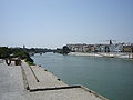
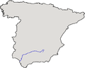
The Guadalquivir is the principal river of southern Spain, running for about 657 kilometres from the mountains of the eastern Sierra de Cazorla to the Atlantic Ocean near Sanlúcar de Barrameda. Its name derives from the Arabic Wadi al-Kabir, meaning "the big river," while the Romans called it the Betis. The river shapes a broad valley that has supported human settlement, agriculture and transport for millennia and remains a defining natural feature of Andalusia.
Image gallery
8 Images


Course and tributaries
The Guadalquivir rises in the highlands of the Sierra de Cazorla (Jaén province) and flows generally west-southwest across Andalusia to its tidal estuary. It crosses the provinces of Jaén, Córdoba, Seville and Cádiz and passes near or through several important towns and cities. Major tributaries include the Genil (which has its upper reaches in the province of Granada), the Guadiana Menor, the Guadalbullón, the Guadajoz, the Guadalmena, the Jándula and the Guadiato. These tributaries contribute to a river system that drains a varied landscape of mountains, plateaus and lowland plains.
Basin, hydrology and landscape
The Guadalquivir basin comprises extensive alluvial plains with fertile soils that have made it one of Spain's most productive agricultural regions. Throughout the basin there are networks of reservoirs, dams and irrigation channels that regulate flows for water supply, farming and flood control. Seasonal variability in rainfall and snowmelt from the uplands influences discharge patterns; human regulation has reduced some natural extremes but also altered sediment transport and wetland dynamics. Floodplains and terraces along the river record a long history of environmental change and land use.
History and cultural importance
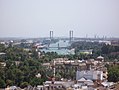
The river has been central to Andalusian history. In antiquity the Betis valley was a major axis of Roman settlement and communication; the river facilitated movement of people and goods and supported urban centres such as Córdoba. During the medieval and early modern periods the Guadalquivir estuary and its access to the Atlantic helped make Seville a principal port for trade with the Americas, when the city functioned as Spain's principal connection to the New World. Archaeological remains, historic towns and cultural landscapes along the Guadalquivir bear witness to successive civilizations: Iberian, Roman, Visigothic, Islamic and Christian.
Ecology and protected areas
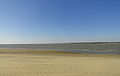
The lower Guadalquivir and its estuary include extensive marshes, wetlands and tidal zones that are ecologically important. Close to the mouth lie internationally significant marshlands and protected areas that provide habitat for migratory birds, fish and diverse plant communities. Wetland restoration, management of water quality and control of invasive species are ongoing conservation priorities. The river corridor supports riparian woodlands, floodplain meadows and agricultural mosaics that sustain regional biodiversity.
Economy, navigation and modern uses
Economically the Guadalquivir basin underpins agriculture (including olive cultivation and cereals), supports industry, supplies urban water and provides opportunities for recreation and tourism. The lower river remains navigable to the port of Seville following dredging and channel maintenance; historically, during Roman times, navigation extended still farther inland toward Córdoba. Navigation, fishing, recreational boating and riverside tourism continue to be important for local economies, although shipping is limited compared with major ocean ports.
Management, challenges and outlook
Contemporary management of the Guadalquivir addresses competing demands for water, flood safety and ecosystem protection. Key challenges include pollution from urban and agricultural sources, over-extraction for irrigation, modification of river habitats by dams and channels, and pressures from invasive species and climate variability. Integrated river-basin planning, habitat restoration and protected-area management are central strategies used by regional and national authorities to balance economic uses with conservation objectives. The Guadalquivir remains a focal point for research, planning and cultural identity in Andalusia.
Notable facts
- The river's Arabic name, Wadi al-Kabir, reflects centuries of Islamic presence in the region.
- Its broad valley has been an agricultural heartland of southern Spain for centuries.
- The estuary and lower marshes are among Spain's important wetland systems and are the subject of ongoing conservation efforts.
Gallery
Related articles
Author
AlegsaOnline.com Guadalquivir River Leandro Alegsa
URL: https://en.alegsaonline.com/art/41134