
Great Rift Valley (East African Rift)
A long continental rift system from Southwest Asia into eastern Africa formed by plate divergence, noted for deep valleys, volcanoes, rift lakes, rich biodiversity and key paleoanthropological sites.
Overview
The Great Rift Valley is an extensive continental rift system that stretches roughly 6,000 kilometres from parts of Southwest Asia into eastern Africa. Rather than a single straight canyon, it is a complex zone of linked rift segments, basins and escarpments. The landscape includes deep valleys, steep fault scarps, highlands and a chain of lakes and volcanoes that record ongoing crustal stretching and faulting.
Image gallery
9 Images



Geology and structure
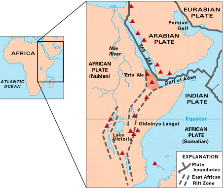
The rift arises where the Earth's crust is being pulled apart by plate tectonic forces. In eastern Africa the process has split the African Plate into distinct blocks (commonly described as the Somali and Nubian plates) and created a network of extensional faults. The system includes two principal branches: the Western Rift (or Albertine Rift) and the Eastern Rift (including the Kenya and Ethiopian rifts), joined to the Afar region where the Red Sea and Gulf of Aden join the rift system.
Notable features
The rift contains many prominent lakes, volcanic centers and mountain ranges. Major rift lakes include Lake Tanganyika, Lake Malawi (Nyasa), Lake Turkana and Lake Albert; they are deep and often host large numbers of endemic species. Volcanic activity ranges from large stratovolcanoes to active basaltic cones, and the region experiences frequent earthquakes associated with fault movement.
- Representative lakes: Lake Tanganyika, Lake Malawi, Lake Turkana, Lake Albert.
- Representative volcanoes and highlands: Mount Kilimanjaro, Mount Kenya, Mount Elgon, and active centers such as Erta Ale and Nyiragongo.
Origins, evolution and future
The rifting began in the Cenozoic era and has progressed episodically over millions of years. Where rifting is most mature the crust has thinned and the surface has subsided to form deep basins. If divergence continues for many millions of years, models suggest the rift could widen into a new ocean basin, as has already happened between the Arabian Peninsula and Africa with the opening of the Red Sea.
Ecology, human history and scientific importance
The Great Rift Valley is a biodiversity hotspot and supports a variety of ecosystems from montane forests and savannas to saline and freshwater lakes with many endemic fishes. Because layers of sediment have preserved fossils, the rift is also one of the most important regions for the study of human evolution: sites such as Olduvai Gorge, the Turkana Basin and Hadar have yielded early hominin remains and stone tools. Several locations in the rift are protected and inscribed as UNESCO World Heritage Sites for their natural and cultural value.
Uses, hazards and conservation
Rift lands provide fertile soils for agriculture, freshwater resources and significant geothermal energy potential, which several countries are harnessing. At the same time the region faces hazards from earthquakes, volcanic eruptions and environmental pressures from land use change and invasive species. Conservation efforts balance biodiversity protection, scientific research and the needs of local communities.
Further information
- General map and overview
- Northward extent and Asian connections
- Southern terminus in Mozambique
- East African context
- Mountain ranges bordering the rift
- Active volcanoes of the rift
- Fault systems and structural geology
- Seismicity and earthquake information
- Modern rifting processes
- Arabian plate separation and the Red Sea
- Plate tectonics background
- UNESCO listings related to the rift
- World Heritage sites and geodiversity
Questions and answers
Q: What is the Great Rift Valley?
A: The Great Rift Valley is a geographical trench that runs from northern Syria in Southwest Asia to central Mozambique in East Africa.
Q: What is the length of the Great Rift Valley?
A: The Great Rift Valley is about 6,000 kilometers or 3,700 miles in length.
Q: What is the cause of the geological activity in the Great Rift Valley?
A: The western part of Africa is rifting away from the eastern part, which causes all the geological activity at the Valley.
Q: How will the geography of the African continent change in the future?
A: Far in the future, a sea will run between the two parts of Africa, as the Arabian peninsula is already almost separated.
Q: What is the significance of the Great Rift Valley in terms of plate tectonics?
A: The whole process of the Great Rift Valley is a part of plate tectonics.
Q: How is the Great Rift Valley divided in eastern Africa?
A: In eastern Africa, the valley divides into two, the Western Rift Valley and the Eastern Rift Valley.
Q: How many UNESCO World Heritage Sites owe their formation to the geography and geology of the Great Rift Valley?
A: There are about 20 UNESCO World Heritage Sites which owe their formation to the geography and geology of the Great Rift Valley.
Tags
Related articles
Author
AlegsaOnline.com Great Rift Valley (East African Rift) Leandro Alegsa
URL: https://en.alegsaonline.com/art/40539