Grand Coulee — a dry Ice Age channel and landmark in Washington state
A large dry canyon in central Washington formed by Ice Age floods. Extends from the Grand Coulee Dam area to Soap Lake and is bisected by Dry Falls, once the site of a massive prehistoric waterfall.
Overview
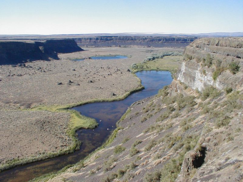
The Grand Coulee is a long, dry canyon-like channel in central Washington state carved into basalt bedrock. Stretching roughly sixty miles in the landscape between the area of the Grand Coulee Dam and Soap Lake, it is a striking example of what geologists call scablands — terrain shaped by large, catastrophic floods rather than slow river erosion.
Image gallery
6 Images


Geology and formation
The coulee was formed during the late Pleistocene by one or more enormous outburst floods commonly associated with the Missoula Floods. These floods released huge volumes of water stored behind an ice dam and scoured the Columbia River Plateau, stripping soil and carving deep channels through layers of Columbia River basalt. The process produced steep basalt cliffs, exposed columns and coulee floors strewn with erratics and gravel deposits.
Characteristics and notable features
- Dry Falls: A dramatic cliff that divides the Grand Coulee into an upper and lower section. Dry Falls is interpreted as the site of a prehistoric waterfall that was many times larger than modern Niagara Falls.
- Length and form: The coulee is an extended, mostly dry trench with terraces, benches and plunge pools left by high-velocity floodwaters.
- Basalt geology: The surrounding bedrock belongs to the Columbia River Basalt Group, which records repeated volcanic flows covered and later cut by flood events.
Human history and uses
In the 20th century the area near the coulee became important for hydroelectric power and irrigation. The construction of major projects nearby transformed local water management and agriculture, and created reservoirs and canals that altered parts of the original landscape. The coulee itself remains largely dry but accessible for scientific study, tourism and outdoor recreation.
Scientific importance and public recognition
Grand Coulee is central to the history of geological thought about catastrophic flooding. Early interpretations that argued for massive Ice Age floods were controversial but later widely accepted when evidence accumulated. Today the coulee and Dry Falls are frequently cited in discussions of flood geomorphology and Quaternary geology, and are visited for both their scenic and educational value. For more on the dramatic cliff known as Dry Falls, see this reference: Dry Falls comparison.
The Grand Coulee illustrates how rare, high-magnitude events can shape regional landscapes in ways that differ from ordinary river processes. It remains an important site for understanding Pleistocene environmental change and for appreciating the scale of geologic forces that have shaped the Pacific Northwest.
Questions and answers
Q: What is the Grand Coulee in Washington state?
A: The Grand Coulee is a dry river that stretches for sixty miles from the Grand Coulee Dam to Soap Lake.
Q: What is Dry Falls in relation to the Grand Coulee?
A: Dry Falls is a feature that divides the Grand Coulee into two parts.
Q: What is Dry Falls thought to be?
A: Dry Falls is thought to be the remains of the largest waterfall ever, two or three times higher than Niagara Falls.
Q: How long is the Grand Coulee?
A: The Grand Coulee stretches for sixty miles.
Q: Where does the Grand Coulee start and end?
A: The Grand Coulee starts at the Grand Coulee Dam and ends at Soap Lake.
Q: What is the Grand Coulee Dam?
A: The Grand Coulee Dam is a large concrete gravity dam located in Washington state.
Q: What is significant about Dry Falls?
A: Dry Falls is significant because it is thought to be the remains of the largest waterfall ever.
Related articles
Author
AlegsaOnline.com Grand Coulee — a dry Ice Age channel and landmark in Washington state Leandro Alegsa
URL: https://en.alegsaonline.com/art/40175
Sources
- commons.wikimedia.org : Grand Coulee
- gonorthwest.com : Dry Falls
- bpa.gov : The Geologic Story of the Columbia Basin