Goiás
![]()
This article explains the Brazilian state. For other meanings, see Goiás (disambiguation).
-15.9333333333-49.3333333333Coordinates: 16° S, 49° W
Goiás [ɡoˈjas] (abbreviation: GO) is a state in the "Midwest" (port.: Região Centro-Oeste) of Brazil.
Its capital and most populous city, with just over 1.5 million inhabitants (2019), is Goiânia. It was laid out according to plan from 1933 as a replacement for the old capital Goiás Velho, formerly just called Goiás. Goiás is centrally located in Brazil and is divided into 246 municipalities (port: municípios) with a total population of just under six million as of the last census in 2010. The population was estimated at 7,018,354 as of 1 July 2019.
Goiás borders (clockwise from the north) the Brazilian states of Tocantins, Bahia, Minas Gerais, Mato Grosso do Sul and Mato Grosso. The Distrito Federal with the Brazilian capital Brasília is almost completely surrounded by Goiás' territory.
Flag
The green horizontal stripes symbolize the mighty Brazilian forests, as in the national flag, and the yellow ones represent the color of gold found in Goiás in the 17th century. The blue rectangle in the upper left symbolizes the sky with five white stars representing the Southern Cross. The flag was adopted on 30 July 1919.
- See also coat of arms of Goiás
Geography
With an area of 340,087 km², Goiás is the smallest of the three states in the Midwest (apart from the Distrito Federal do Brasil) and is thus almost as large as Germany (357,112 km²). In a size comparison with all 26 states, Goiás ranks seventh with an area share of 3.99%, but only twelfth in terms of population. The population density is only 17.7 inhabitants per km².
| The geography of Goiás is largely characterized by the central Brazilian plateau (port.: planalto central) with its low mountain ranges. It joins the mountains running along the Atlantic coast to the west. This landscape, heavily weathered by erosion, has a relatively low altitude compared to the peaks of the low mountain ranges. Some well-known plateaus are:
|
| The high plateau, which extends in the southwest of Goiás also in the west adjoining state of Mato Grosso, forms the watershed between the Amazon basin in the north and the southern river system Paraná, which flows via the Río de la Plata between Argentina and Uruguay into the Atlantic Ocean. To the east, Goiás borders the third river system, the northeast-flowing Rio São Francisco. In the northwest of Goiás is the Araguaia lowlands, with an altitude of only 300 m. |

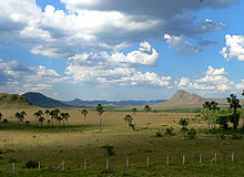
Plateau Jardim de Maytrea in the Chapada dos Veadeiros with low mountains in the background.

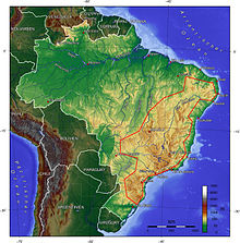
Brazilian mountainous country along the coast and west of it the plateau with the low mountain ranges.
Search within the encyclopedia