There are globes of the constellations (celestial globes), the moon and other planets.
Earth globes are divided into physical globes and thematic globes. Physical globes are designed like geographical (topographical) maps. Some also show the ocean floor as a geographical map.
Thematic globes are mainly the political globes. But there are also thematic globes about the geology of the earth, geotectonics, climate, economy or traffic.
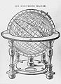
Manuscript Globes
Manuscript globes (from manuscript or handwriting) were hand-drawn globes in which all inscriptions and entries were also made by hand. They were not handwritten print copies that were later to be reproduced by printing. These manuscript globes were individual pieces. Only much later did serial production and then mass production of the globes follow.
Some globes were made on stone, metal or ivory spheres. On such solid globes the map image is sometimes plastically highlighted. They may be engraved or painted. Mostly, however, the map image was glued on from strips of paper. Solid wooden spheres or hollow wooden hemispheres were also used.
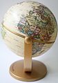
School globes
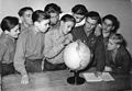
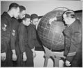
The school globe was used as a teaching and visual aid for school lessons, also for explaining and illustrating geographical phenomena (rotation of the earth, position of the sun, tropic of revolution, polar night, Coriolis force, time zones, sundials, great circles and great circle navigation, etc.). In Austria, globes were used as teaching aids in general schools from 1870 onwards.
A special version is the dumb globe, on which only the earth's grid of degrees, the contours of the continents, the largest rivers and all national borders are drawn, but no labelling (country names, city names, geographical designations) or geographical information. On these globes, which have no actual map content, various facts can be drawn for teaching purposes, e.g. with chalk or felt-tip pen. There are also dumb globes on which only the outlines of the continents (without country borders) are drawn. On other didactic globes, the continents and the oceans are clearly separated by colour to illustrate the relationship between the world's oceans and land masses. There are also school globes on which only the individual continents are shown in different colours.
Another version of the dumb globe is the induction globe, which only shows the degree network of the sphere, so that physical-mathematical relationships can be explained well on it. The induction globe was invented by Joseph August Brandegger in Ellwangen and served as a practical introduction to mathematical-geographical teaching.
· 
Table globe in geography class 1943 with applied analemma
· 
Pupils at the school globe 1951
· 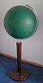
Induction globe with degree network
· 
Induction globe with degree network as well as mute map of the coastlines of the continents
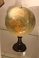
Glow-in-the-dark globes
The company Räthgloben 1917 Verlag sold possibly the first illuminated globes in 1921, which were made on a glass sphere and illuminated from the inside with electric light bulbs. From the 1950s onwards, illuminated globes were then offered as duo globes, which had additional map information on the inside that became visible when the lighting was switched on. Depending on the manufacturer, the globe would show the political or physical map image when unlit and the other map image when lit. Depending on the manufacturer, they are also called double-image illuminated globes, two-image illuminated globes or double-illuminated globes
Duogloben is also available in a version with day and night display.
Another variant of the illuminated globe is the alternating image globe, in which the earth globe and the celestial globe are combined in a single globe.
Digital globes
Digital globes, also known as virtual globes, have been modeling the Earth in three dimensions since the late 20th century. Unlike the traditional analog globe, digital globes have a seamless, distortion-free map image. They can achieve a much higher resolution map display than conventional real globes. They are much more up-to-date, interactive and scalable. Examples of virtual globes are NASA's World Wind globe, Google Earth, Marble or National Geographic's 3D globe.
· 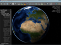
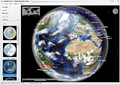
Digital Globe NASA World Wind
· 
Projection globe
Since April 2007, the Swiss Science Center Technorama in Winterthur has had the "Orbitarium" mega-globe. High-resolution videos with animations are projected onto the 1.5 m globe, for example the passage of hurricanes, ocean currents, the change of seasons, the migration of the magnetic pole or global air traffic.
Hyperglobes
A "hyperglobe" is a multimedia globe that is computer-based and linked to the Internet and can be interactively designed by the user. This virtual globe can be designed with integrated texts, images and animations tailored to the user's needs.
Palaeogloben
There are so-called paleo globes, in which, taking into account the theory of earth expansion, which states that a few hundred million years ago the earth was only half the size it is today, the earth is represented accordingly. Alfred Wegener concluded from the exact fit of the coastlines of South America and Africa that they must once have formed a larger continent together. He reconstructed a supercontinent called Pangaea, which included all known parts of the earth and protruded from the world's oceans. Paleo globes and computer animations show that today's continents can be used to almost completely close a much smaller globe. The first paleo globes were made by Christoph Hilgenberg.
Other globe types
Relief globes show a strongly exaggerated relief of the large mountain ranges. For example, if the relief of the mountains were reproduced to scale, Mount Everest would only have a height of 0.5 mm on a globe with a diameter of 60 cm. Since the inscription on relief globes is made on an uneven surface, it is difficult to read in some places. Mostly relief globes also show the sea relief. The superelevation can also be chosen differently for different altitude ranges. For example, up to 1000 m NN a 60-fold superelevation and above only a 40-fold superelevation, as well as a 40-fold superelevation for the relief of the oceans. A cheaper alternative to relief globes are globes with a smooth surface, where the mountains are only shown with relief shading. Tactile globes are also produced for the visually impaired.
Often the ocean currents are also shown on globes, differentiated by cold and warm ocean currents. There are also globes where, especially on the seafloor, the tectonic plate boundaries are additionally drawn.
· 
· .jpg)
Bathymetric globe made by Bruce C. Heezen and Marie Tharp
· 
Pocket globe made by Charles Price 1716
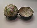
Pocket globes (also: miniature globes; English pocket globe, French globe de poche) have a diameter of 5 to 12 cm. They are usually transported and stored in a tin, box or case. Pocket globes can also be made of precious woods, for example mahogany or walnut, or of ivory.
The pocket globe is a special form of the pocket globe. It is a folding pocket globe, inside of which, for example, a small, removable armillary sphere is stowed.
In 1827 Caspar Garthe called a celestial globe made of two glass hemispheres, inside of which he placed a wooden globe.
Other types of globes are thematic globes (for example traffic globes - with drawn-in streams of worldwide shipping traffic), children's globes (with drawn-in typical animals of the region), globes made of precious stones or mother-of-pearl, designer globes, moon globes and the "Globus von Mecklenburg" by the Räth-Globen company, which appeared in the early 1990s (see also Rudolf Tarnow), an ironic allusion to outdated conditions in Mecklenburg.
Inflatable globes are especially used for very large models of the globe. Despite their enormous size, they are still easy to transport and still fit through normal doors when collapsed. If filled with gas, they can also fly as tethered balloons. Inflatable globes are sometimes also designed so that the water surfaces are transparent.
Climate globes show not only the continents but also a strong cloud image on the globe, similar to satellite images.
There are also satellite image globes, where the map image consists of satellite images, but without the representation of clouds.
A "cutaway globe" shows the inner structure of the Earth's mantle, crust and core. It can be partially opened to "see" inside the Earth.
A traffic globe shows the flow of goods and travel routes of air and shipping routes.
Well-equipped newer globes have additional functions, such as:
Decorative globes can be attached to buildings for ornamentation and as a symbolic element, stand as decoration in representation rooms, in libraries or in the study of scholars. Globes are also occasionally used as a decorative element in combination with clocks or bookends.
Also, antique globes (facsimile, antique globe replica), antique style globes, or antique design globes are republished in simplified, cheaper versions. Genuine antique globes are sold through the art trade.
Map representations of the globe are:
- Planiglobus (plural: planiglobes) - this is the image of a hemisphere of the earth in a circular network.
- Planisphere - it represents the entire surface of the globe in a closed form.
Spherical cards
As an alternative to globes, there are spherically curved maps (globe segment). However, these spherical maps, which in a way represent an intermediate between globe and normal (flat) maps, did not find widespread use. Today, digital globes have made such spherical maps superfluous.
A convex (spherically curved) surface (spherical calotte) serves as the card carrier. In fact, these maps do not differ from a very large globe that has been cut into individual handy pieces. Just as on a globe, the representation on a spherical map is true to area, angle and length. Spherical maps can be cut out rectangular or circular.
On the one hand, this avoids the problem of projection distortion of planar maps, and on the other hand, the spherically curved map sheets (usually made of plastic) can still be stored and transported somehow practically, and it is cheaper than a globe. Thus, large bulky globes are not needed to display maps at larger scales without distortion. The dimensions of large globes are already problematic for transport because they do not fit through a normal door (about 1 m wide), if necessary large globes are disassembled into two hemispheres for transport.
For example, spherical maps were made for didactic purposes at the Science Museum of Minnesota in Saint Paul (Minnesota) in 1941, as part of an exhibition with the question: "Can America be bombed?". Several spherical maps were compiled into an "Atlas of spherical maps" that measured 22 × 25 inches (56 × 66 cm). The scale corresponded to a globe 3 m in diameter. On these spherical maps, the visiting public could take measurements of the range of bombers.
The US Army tested the production of spherical maps at a scale of 1:1 million ("design and production of spherical map sections displaying a portion of the globe at a scale of 1:1,000,000").