
Glenrowan, Victoria — historic town in north‑east Victoria
Glenrowan is a small rural town in north‑east Victoria, Australia, best known for the 1880 siege of the Kelly Gang. It lies near the Warby Ranges, close to Wangaratta and the Hume transport corridor.
Overview
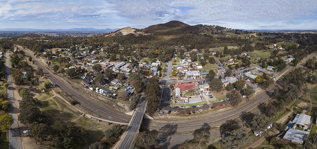
Glenrowan is a small rural town in the north‑east of Victoria, Australia. It lies about 184 km north‑east of Melbourne and roughly 14 km from Wangaratta. Set near the Warby Ranges and the foothills of Mount Glenrowan, the town is rural in character and serves as a local centre for farming and for visitors interested in colonial history and bushranger heritage.
Image gallery
5 Images


History and the Ned Kelly siege
Glenrowan is most widely known for its role in the final confrontation between police and the Kelly Gang in 1880. The gang's last stand in and around the town has a prominent place in Australian cultural history. Contemporary reports and later histories describe how the gang occupied parts of the town, held hostages, and prepared to resist a police party; the siege that followed ended with the capture of the gang leader, Ned Kelly. The episode has inspired numerous books, films and public memory, and has shaped Glenrowan's identity as a site of national historical interest.
Geography and transport
The township sits close to the Warby Ranges and local elevations such as Mount Glenrowan, giving a landscape of cultivated plains and low hills. Historically the town lay on the main road corridor between Melbourne and Sydney. The original route of the Hume Highway ran through Glenrowan, bringing long‑distance traffic and trade. A modern alignment and freeway bypass now diverts most through traffic away from the town, reducing heavy traffic on its main street and helping preserve its historic streetscape.
Economy and community
Glenrowan remains a small community with an economy based largely on agriculture, local services and tourism. Surrounding properties are used for grazing and mixed farming, and the wider region includes well‑known high country and wine districts. Residents rely on nearby regional centres such as Wangaratta for many services, while the town itself supports visitor facilities, hospitality venues and small businesses serving locals and tourists.
Attractions and heritage
The principal attractions are those connected with the 1880 siege and the Kelly story: interpretive displays, heritage trails, memorials and preserved 19th‑century buildings. Local museums and information centres provide context on colonial policing, bushranging and rural life in the late 19th century. Outdoor recreation in the Warby Ranges and nearby bushland complements the historical attractions, offering walking and photography opportunities for visitors.
- Heritage interpretation: museums and interpretive panels recount the events of 1880 and the town's wider colonial history.
- Historic structures: surviving buildings, memorials and markers are focal points for visitors.
- Outdoor activities: nearby ranges and rural landscapes provide short walks and vantage points for the scenery.
- Events: occasional commemorations, guided walks and local festivals draw interest from history enthusiasts and regional tourists.
Visiting Glenrowan
Glenrowan is a small town with limited but welcoming visitor facilities; those planning a trip should check opening hours for museums and services. The Hume transport corridor and regional centres make the town accessible by road, while local accommodation and hospitality options are sized to suit a modest number of tourists. As a destination it combines historical interpretation with accessible natural scenery, making it a common stop for travellers exploring north‑east Victoria and the Hume corridor.
For regional context and travel planning, consult resources about the Hume route and north‑east Victoria. Glenrowan's story remains an important strand in Australia's colonial history and continues to attract visitors interested in the Kelly saga and rural heritage.
Victoria | Australia | Hume Highway | Melbourne | Wangaratta | Sydney
Questions and answers
Q: Where is Glenrowan located?
A: Glenrowan is located in the northeast of Victoria, Australia.
Q: How far is Glenrowan from Melbourne?
A: Glenrowan is 184km northeast of Melbourne.
Q: How far is Glenrowan from Wangaratta?
A: Glenrowan is 14km from Wangaratta.
Q: What is the population of Glenrowan according to the 2006 census?
A: According to the 2006 census, the population of Glenrowan was 952.
Q: What is the significance of Glenrowan?
A: Glenrowan used to be on the main road between Melbourne and Sydney, the Hume Highway.
Q: What is the current status of the Hume Highway in relation to Glenrowan?
A: The new Hume Freeway now goes around the town.
Q: What are some geographical features near Glenrowan?
A: Glenrowan is near the Warby Ranges and Mt. Glenrowan.
Related articles
Author
AlegsaOnline.com Glenrowan, Victoria — historic town in north‑east Victoria Leandro Alegsa
URL: https://en.alegsaonline.com/art/39190
Sources
- censusdata.abs.gov.au : "Glenrowan (State Suburb)"
- smh.com.au : "Glenrowan Victoria"
- glenrowan1880.com : "History"
- premierpostal.com : Post Office List
- nla.gov.au : "Latest Telegrams, The Maitland Mercury & Hunter River General Advertiser"