Giessen
![]()
This article is about the city of Giessen; for other meanings see Giessen (disambiguation).
Giessen is a university town in the district of Giessen in Central Hesse and, with 90,131 inhabitants (31 December 2020), the seventh largest city in the state of Hesse and one of the state's seven special-status cities. As the seat of the administrative district of Gießen and the county, it is the administrative centre of Central Hesse, an important transport hub and one of the region's major centres.
Together with Wetzlar in the Lahn-Dill district, ten kilometres to the west, the city forms an agglomeration area with a population of around 200,000, and the surrounding region has a population of around 275,000. Further away are the cities of Marburg (Marburg-Biedenkopf district) up the River Lahn, Fulda (Fulda district) on the other side of the Vogelsberg, Siegen (Siegen-Wittgenstein district) in South Westphalia, Friedberg (Hesse) and Bad Nauheim in the Wetterau district, and Limburg an der Lahn (Limburg-Weilburg district) on the edge of the Westerwald.
The city is home to the Justus Liebig University, several departments of the Technical University of Central Hesse, the Free Theological University of Giessen and a department of the Hessian University of Police and Administration, the initial reception facility of the State of Hesse for refugees and the state office of the State Student Council of Hesse.
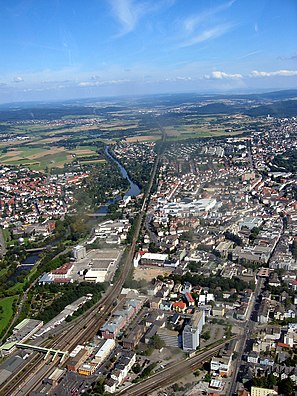
Aerial view of Giessen's city centre and the river Lahn
Geography
Geographical position
Giessen is located on the course of the Lahn River, where it changes its course from a southern to a western flow direction, in one of the rare widenings of the Lahn Valley. Coming from the north, the Lahn flows through the Lahn valley from Marburg towards the city. The northwest is occupied by the foothills of the Gladenbacher Bergland. This is fronted by the Gleiberger Land with the castles of Gleiberg and Vetzberg and the Dünsberg, the highest elevation in the wider Giessen area at 498 metres. In the west, the Lahn valley opens up to Lahnau-Atzbach. Here are gravel deposits that were dredged, then a local recreation area including a water sports center was established there. In the southwest of the city begins the Hintertaunus, the northeasternmost natural unit of the Taunus, which is followed in the south by the Wetterau and the Rhine-Main lowlands (see list of natural units in Hesse). In the east, the Gießener Land merges into the low mountain range of the Vogelsberg.
Larger cities in the vicinity of Gießen are the two major centres of Wetzlar 12 kilometres to the west and Marburg 30 kilometres to the north, both of which also lie on the Lahn, as well as Fulda 80 kilometres to the east, Butzbach 18 kilometres to the south and Frankfurt am Main 70 kilometres to the south.
Neighboring communities
Neighboring communities are (clockwise, starting in the west):
|
|
|
City breakdown
The old core city of Gießen forms the main part with a size of about 40 km² and about 65,000 inhabitants. In addition, according to the main statutes, five other districts belong to the city area as formal local districts with local councils. The districts Wieseck in the northeast and Kleinlinden in the southwest were incorporated in 1939, the districts Allendorf an der Lahn in the southwest and Rödgen in the east in 1971. Lützellinden in the southwest followed in 1979.
Existing settlements and new residential and commercial areas that are only partially intertwined with the core city are only named by the population and are officially part of the core city. This concerns the commercial area "An der Automeile" with the former Rivers barracks, the Europaviertel, the Anneröder Siedlung, the Dulles-Siedlung, the Eulenkopf, the so-called "Gummiinsel" in the Weststadt - a workers' settlement of a rubber factory formerly located there -, the Marshall-Siedlung, the Philosophenviertel, the new housing estates Sandfeld and Schlangenzahl, the Unterer and Oberer Hardthof as well as the commercial area Ursulum/Oberlachweg. The Petersweiher housing estate, located in the southeast at the foot of the former Schiffenberg monastery, is also part of the core city of Gießen. It was built in 1973, when the then uninhabited Schiffenberg district became the property of the city. Although this had been annexed to the city since 1939, it had until then been owned by the state. The settlement In der Hunsbach, which is located around the Badenburg, has officially belonged to Wieseck since 1752, despite its relatively large distance from the town - just like the ruins of the Badenburg and the Wellersburg.
For statistical purposes, Giessen is still divided into eleven statistical districts:
| No. | Area | Residents on30 |
| 01 | Downtown | 21.173 |
| 02 | North | 10.309 |
| 03 | East | 16.305 |
| 04 | South | 10.485 |
| 05 | West | 08.394 |
| 06 | Wieseck | 10.158 |
| 07 | Rödgen | 01.907 |
| 08 | Schiffenberg | 00.0588 |
| 09 | Kleinlinden | 04.777 |
| 10 | Allendorf | 02.071 |
| 11 | Lützellinden | 02.439 |
| Total | Casting | 88.606 |
Climate
The climate in Giessen is one of the most humid and temperate in Germany. The coldest month is January with -0.1 °C, the warmest is July with 18.2 °C. In early spring it is generally dry. The month with the least rainfall is thus March with 31 mm precipitation. Compared with other Hessian stations, Giessen is the driest in March (Frankfurt/Main: 51 mm, Fulda: 48 mm, Kassel: 51 mm, Marburg/Lahn: 56 mm, Darmstadt: 49 mm). The month with the most rainfall is June with 66 mm, which is again in the lower range compared to other Hessian stations (Frankfurt/Main: 70 mm, Fulda: 73 mm, Kassel: 79 mm, Marburg/Lahn: 66 mm, Darmstadt: 74 mm). The annual precipitation is also comparatively low.
| Casting | ||||||||||||||||||||||||||||||||||||||||||||||||
| Climate diagram | ||||||||||||||||||||||||||||||||||||||||||||||||
| ||||||||||||||||||||||||||||||||||||||||||||||||
| Monthly average temperatures and precipitation for Giessen
Source: wetterkontor.de | |||||||||||||||||||||||||||||||||||||||||||||||||||||||||||||||||||||||||||||||||||||||||||||||||||||||||||||||||||||||||||||||||||||||||||||||||||||||||||||||||||||||||||||||||||||||||||||||||||||||||||||||||||||||||||||||||||||||||||||||||||||||||||||||||||||||||||
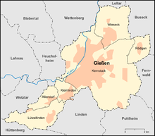
Giessen and its five districts
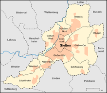
Statistical districts of Gießen
History
→ Main article: History of the city of Gießen
First settlement
Wilhelm von Gleiberg founded a moated castle in the valley below in 1152 and later moved his seat there from Gleiberg Castle; this laid the foundation stone for the later town of Giessen. Gleiberg Castle, about 8 km northwest of today's town, was built by the Conradines around the 10th century and passed to the Luxembourgs at the end of the 10th century, who thus established the County of Gleiberg on the middle Lahn.
On the way to the city
The first documented mention of the name (of the) "Giezzen" dates from 1197. In 1248 Giessen was first attested as a town. In 1264 Giessen was sold by Count Ulrich I of Asperg of the House of the Palatine Counts of Tübingen, to whom it had fallen by inheritance, to the Landgraviate of Hesse, which had today's Old Castle built around 1300. Around 1325 the new town was founded. From about 1370 onwards there were mayors in Giessen who were on an equal footing with the lordly burgomasters, as well as a council representing the citizens. The Old Town Hall on the market square, destroyed in 1944, was built around 1450 as a symbol of civic power, the town church by 1484. In 1442 Giessen received the market privilege. Today's "Marktplatz" still served as a market place at that time, while today the weekly market is held at Lindenplatz, in the market arbours (Old Market Arbours 1894, New Market Arbours around 1910) and at Brandplatz.
Foundation of the University
Around 1535 Landgrave Philip the Magnanimous had the town fortified. In the same decade the Old Cemetery and the New Castle were built. On 27 May 1560 a major fire destroyed the northern part of the town around the Walltor. When the Landgraviate was divided in 1567, Giessen became part of Hesse-Marburg, and in 1604 of Hesse-Darmstadt. In 1605 the Gymnasium Ludovicianum was founded in Giessen by Landgrave Ludwig V as a Latin school. On 19 May 1607, a privilege granted by Emperor Rudolf II made it possible to found the university, as a counterpart to the one in Marburg. Two years later, the Botanical Garden, today one of the oldest in Germany, opened on its original site. In 1634/35 a severe plague epidemic decimated the population of the town. In the 18th century, the region was ravaged by wars several times and the city was occupied by foreign troops.
19th century
In 1803 Giessen became the capital of the new province of Upper Hesse in the Grand Duchy of Hesse. In the following years, the city fortifications were demolished and the ramparts (green spaces) were laid out in their place. From 1824 to 1852 Justus Liebig taught at the University of Giessen, which was named after him after the Second World War. On 14 January 1838, the "School for Technical Drawing" was founded, a precursor of today's TH Mittelhessen (THM).
In the revolutionary year of 1848, there were also riots in Giessen; a student was killed. August Becker published the radical democratic daily newspaper "Jüngster Tag" in Giessen. In 1849 the city was connected to the German railway network with the opening of the Main-Weser railway (Frankfurt-Kassel). In 1862 the railway line to Cologne followed, and in 1864 the connection to the Lahn Valley Railway from Wetzlar to Koblenz. From about 1860, especially during the term of office of the first professional mayor August Bramm (1875-1889), the town grew beyond the ramparts.
In 1855 the works fire brigade of the Gail'schein Werke was founded, in the same year also the municipal volunteer fire brigade of Gießen.
From 1867 onwards, Giessen was a garrison town and a military base for Infantry Regiment No. 116. In 1870 the Vogelsberg Railway to Fulda opened, and in 1872 the Lahn-Kinzig Railway to Gelnhausen. From 1879 to 1888 Wilhelm Conrad Röntgen taught at the University of Gießen. In 1893, what is now the town's largest church, the Protestant Johanneskirche on the Südanlage, was consecrated. In 1907 the municipal theatre, initiated by citizens, opened. From 1894 there was public transport in Giessen, first with horse-drawn buses, since 1909 with an electric tram.
20th century
In 1903 the New Cemetery was put into operation as an interdenominational municipal cemetery. One year later, the advanced Giessen sewer system was inaugurated. In 1914 the professional fire brigade was founded. The "Volkshalle" on today's Grünberger Straße and the Giessen Airport were opened in 1925.
With effect from November 1, 1938, the Reich Governor in Hesse, in his function as leader of the state government, decreed not only that the cities of Darmstadt, Mainz, Offenbach and Worms, but also the city of Giessen be separated from their previous district. Giessen thus became an independent city. The incorporation of Wieseck, Kleinlinden and Schiffenberg increased the population to 42,000 in 1939. On 10 September 1955, the Hesse State Fire Brigade Association, founded the year before, held its first association meeting in Giessen.
Military
Giessen was interesting as a military location after the First World War and the provisions of the Treaty of Versailles of 1919 because it lay just outside the demilitarised zone. In the 1930s and 1940s, around 467 hectares of urban land were given to the army and air force for a small price during the rearmament. More barracks were built: artillery barracks (Bleidorn Barracks, later Pendleton Barracks) and forest barracks (Verdun Barracks, later Rivers Barracks). A site training area was established between the former Steuben Barracks and Hohe Warte. Other barracks included Zeughauskaserne and Neue Kaserne (Berg-Kaserne).
From 1936 to 1939 a military hospital was built on the corner of Schubertstraße and Karl-Franz-Straße. It remained undestroyed during the Second World War and, like the Giessen barracks, was used after 1945 first by the US Army, and from 1951 by the French armed forces. In 1957 it was returned and put into service as a Bundeswehr hospital; later renamed Bundeswehrkrankenhaus. In 1997 it was closed; after a conversion, the building is now used by the tax office, among others.
On the site of today's Automeile (Rivers Barracks), the Wehrmacht maintained the Gisela intelligence bunker, which was used, among other things, to coordinate the attackon France in 1940. Large parts of the facility still exist today.
Giessen has the most still existing angular bunkers in Germany. Spread over the entire city area, there are still eight examples.
air raids
The Royal Air Force's No. 5 Bomber Group bombed Gießen on 2 December and the night of 6-7 December 1944 under the Area Bombing Directive. In the second raid ('operation hake') almost the entire historic centre of Giessen was destroyed by a firestorm; some 390 people died and around 30,000 were left homeless. The railway station, the railway facilities and the numerous military installations, on the other hand, remained largely intact. It could have been even worse for Giessen: A not inconsiderable portion of the bomb load from the second air raid was accidentally dropped over the Bergwerkswald. Many of the circular ponds there are bomb craters.
On 11 December 1944, 353 B-17 bombers of the USAAF dropped 731 tons of high explosive bombs and 1116 tons of incendiary bombs under closed cloud cover. The main area hit was between Ludwigstraße and the industrial area / Bergwerkswald. In the following months many more people died as a result of low-flying air raids. On 28 March 1945, the arrival of US troops ended the war for the people of Giessen. The city was two-thirds destroyed, the inner city 90 percent.
See also: List of Allied air raids on the German Reich (1939-1945)
Emergency camps after 1946
At the end of October 1945, the military government of the USA informed the state government of Greater Hesse that the state would have to take in around 600,000 displaced persons and refugees in 1946. At the beginning of February 1946, the first 1,200 people reached the city in freight cars. The initially provisional "refugee transit camp" was located not far from the railway station in Meisenbornweg. Since Giessen was a rail junction, the State Commissioner for Refugees made it a government transit camp for all refugees to Greater Hesse on May 7, 1947. In 1948, the mayor Otto-Heinz Engler asked the Regierungspräsidium in Darmstadt to relocate the camp because of the heavy burden the refugees placed on the city's social budget. Later, the mayor Hugo Lotz obtained financial compensation for the city from the state.
On September 1, 1950, the camp was renamed the Gießen Emergency Reception Camp and was given nationwide authority. The proportion of displaced persons at this time was already one fifth of the total population of Giessen. The Gießen emergency reception camp was also a transit camp for refugees from the Soviet occupation zone who wished to remain in the American zone. From the 1960s onwards, it was the first stop for numerous GDR citizens who had left the country; in 1989 it first experienced the onslaught of East Germans who had fled via Hungary, and in the autumn that of those who had come legally across the now open border. In 1986 it was renamed Bundesaufnahmestelle (Federal Reception Centre); today the initial reception centre of the state of Hesse is located at a site on the former US Depot Giessen in Rödgener Straße. The site in Meisenbornweg is to become a joint memorial of the state and the federal government.
Reconstruction
Reconstruction was guided by the lessons of modern urban planning: old town plots were grouped into large units, street and square spaces were extended and public space was largely adapted to the interests of motor traffic. In 1953, the last line of the Giessen tram, which had previously been lavishly rebuilt, was shut down; trolley buses ran in its place until 1968.
Many of the few streets in the city centre that had been spared from the bombing were demolished, as were some of the ruins that had been preserved, such as the ruins of the 500-year-old town hall, which could certainly be rebuilt. New buildings were erected in the style of the 1950s, including the high-rise public authority building at Berliner Platz (which has already been demolished) and the Congress Hall, as well as the Stadthaus, which was built in 1961 and demolished in 2006.
The last wartime ruin of the city centre was a rear building in Goethestraße; it was demolished in 2004. The arterial roads, the ramparts and the most important axes of the city centre were developed into multi-lane traffic roads (Anlagenring). Until 1975, numerous motorway sections were built around Gießen, including the Gießener Ring (partly expressway).
US Army
Giessen became a location for US Army troops after the Second World War. Among other things, the Steuben Barracks were under its command. The US Depot Giessen and the site of the Army & Air Force Exchange Service (AAFES) had an important supply function for the US Army in Europe. During the Cold War, the properties served included the special ammunition depot in Giessen and the special ammunition depot in Alten-Buseck with nuclear warheads and the Patriot position Hohe Warte. On the Hohe Warte the Americans still have a military training area today. The permission was granted in 2000, although it is now a nature reserve.
The cityscape, the social structure and especially the gastronomy (many bars) of the city were strongly influenced by members of the US Army in the 1950s and early 1960s. In 1947/48 there was a pronounced black market in Giessen's Bahnhofsviertel, especially with cigarettes and discarded - also new - uniform parts (trousers, jackets, parka) of the Americans. "Yank cigarettes" were also considered a means of payment during this time. Discarded cigarettes were collected by "Kippenstecher" or "Kippenleser" and new cigarettes were rolled from the tobacco. At that time the Giessen "Kippenleser Blues" was created with the lyrics: "Babbe gugg, do unne laid en Kippe, vo e'r gure Chesterfield, heeb en off, da hu m'r aut ze räche, so eh gure Chesterfield ..." to the tune of "In the Mood".
After the end of the Cold War, the number of Americans was gradually reduced and the final withdrawal was completed with the closure of the depot in September 2007. The U.S. depot was an important economic factor for decades, employing up to 3,500 non-American workers during its heyday.
Episode "City Lahn"
→ Main article: Lahn (city)
On 1 January 1977, in the course of the territorial reform in Hesse, the city of Lahn was created by virtue of state law from Gießen, Wetzlar and 14 surrounding municipalities as the upper centre of Central Hesse with 155,247 inhabitants. After only 31 months of existence, it was dissolved again on 1 August 1979. In the course of this, Gießen received the district of Lützellinden.
21st century
In 2005, after a one-year construction period, the Galerie Neustädter Tor was opened. It combines several shops in one building complex. There is a direct bus and train connection through the two stops at Oswaldsgarten. An integrated multi-storey car park has 1100 parking spaces.
In 2006, after the demolition of the old town hall from the 1950s, the construction of the new town hall of 2009 at Berliner Platz began, in which almost all authorities were brought together again. New medical centres such as the day clinic in the Nordanlage, an extension of the university hospital, the new Martinshof next to the St.-Josefs-Hospital and the care centre in Grünberger Straße were built.
In 2012, the new Biomedical Research Center of the Justus Liebig University was inaugurated on the Seltersberg. It stands out with its striking colours and distinctive architectural style.
Incorporations
In 1939, the surrounding communities of Wieseck (north) and Kleinlinden (south) were incorporated. Before the district-free city of Giessen merged into the city of Lahn in 1977, the communities of Allendorf an der Lahn and Rödgen were incorporated on a voluntary basis in the course of the territorial reform in Hesse on October 1, 1971. Lützellinden followed in 1979 and is thus the youngest district of Gießen.
See also: List of incorporations into the cities of Gießen and Wetzlar
Population
Resident structure
According to the 2011 census, 74,776 people lived in Giessen on 9 May 2011. Among them were 8412 (11.2 %) foreigners, of whom 2387 came from other EU countries, 3222 from other European countries and 3803 from other countries. Of the German residents, 21.9% had a migration background. The inhabitants lived in 40,679 households. Of these, 19,862 were single households, 8183 couples without children and 6,589 couples with children, as well as 2914 single parents and 3131 shared flats.
Population development
Giessen had only a few hundred inhabitants in the Middle Ages and only a few thousand in the early modern period. The population grew only slowly and declined again and again due to the numerous wars, epidemics and famines. In 1634/35, for example, a severe plague epidemic killed many inhabitants. Only with the beginning of the industrialization in the 19th century the population growth accelerated. While in 1800 only 4800 people lived in the town, in 1900 there were already 25,000. The effects of the Second World War are clearly visible. By the end of the war, two thirds of the buildings had been partially or totally destroyed by Allied air raids. According to estimates, about a thousand people were killed. The population dropped from 47,000 in 1939 to 25,000 in March 1945.
In 1971, the number of inhabitants rose to 78,109 due to the incorporation of Allendorf and Rödgen - a historic high until 2011. On 30 June 2005, the official population according to the Hessian State Statistical Office was 73,358 (only main residences and after comparison with the other state offices). Since 1963, the city's population has been above the 70,000 mark - except in 1987 - and the 80,000 mark was exceeded in 2014. The current number of inhabitants places Giessen among the one hundred largest municipalities in Germany.
The following overview shows the population figures according to the respective territorial status. Up to 1828, these are mostly estimates, thereafter census results (¹) or official updates of the State Statistical Office. From 1871 onwards, the figures refer to the "local population", from 1925 onwards to the "resident population" and since 1987 to the "population at the place of principal residence". Before 1871, the number of inhabitants was determined according to non-uniform survey methods.
|
|
|
|
¹ Census result
Confession statistics
| - • 1961: | 32,030 Protestant (= 43.2 %), 14,250 Catholic (= 19.2 %) inhabitants |
| - • 2011: | 31,980 Protestant (= 42.8 %), 14,200 Catholic (= 19.0 %), 28,590 other, non-denominational, not specified (= 38.2 %) |
Population development of Giessen. Above from 1495 to 2016. Below an excerpt from 1871. The episode "City of Lahn" is marked with a light green bar.
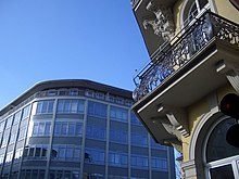
Imprint: Architecture of the 1950s and Gründerzeit buildings
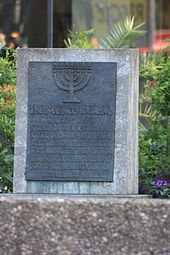
Memorial stone for the synagogue destroyed in 1938
.jpg)
Market place around 1840
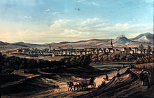
Giessen: Beginning of the 19th century
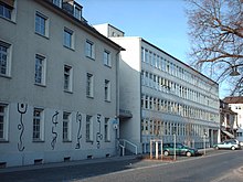
Gießen regional council
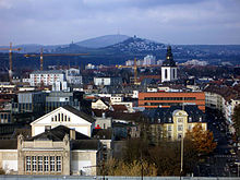
Giessen: in the background on the left castle Vetzberg, on the right castle Gleiberg, in the background the Dünsberg
Questions and Answers
Q: What is the character present in the title of this article?
A: The character present in the title of this article is "ß".
Q: What can be used instead of the name Giessen?
A: The name Giessen can be written as Gießen or Giessen where the character ß is unavailable or not wanted.
Q: What is Giessen?
A: Giessen is a city located in the German state of Hesse, which has about 73,000 inhabitants.
Q: How far is Giessen from Frankfurt?
A: Giessen is located about 50 kilometres (31.1 miles) north of Frankfurt.
Q: How many students does the University of Giessen have?
A: The University of Giessen has about 20,000 students.
Q: What is the meaning of the German word "Giessen" in English?
A: The German word "Giessen" means "to pour" in English, like "to pour a glass of water."
Q: What surrounds the city of Giessen?
A: The city of Giessen is surrounded by many lakes and streams, and it is located on the banks of the Lahn River.
Search within the encyclopedia

