Ghent — Belgian city, port, and cultural center
Ghent is a historic city in East Flanders, Belgium, known for its medieval architecture, university, canal network and lively cultural and music scenes. Population around 262,000 (2019).
Overview

Ghent is a major city and municipality in the Belgian province of East Flanders. Located at roughly 51.05°N, 3.73°E, it sits where several waterways converge and has long served as an inland port and regional hub. The city had about 262,000 residents in 2019 and combines a compact historic centre with modern university and research districts.
Image gallery
10 Images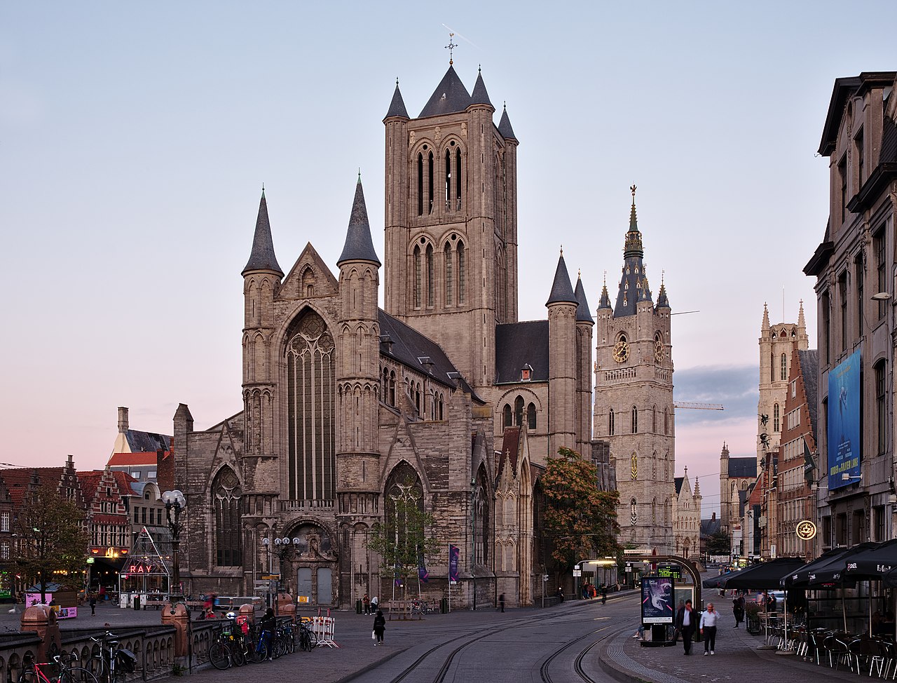


Characteristic features
Ghent is noted for its well-preserved medieval core, busy waterways and prominent landmarks. Key sites include the castle-like Gravensteen, Saint Bavo's Cathedral with its famous altarpiece, the medieval belfry, and an interwoven network of canals and quays that shape the city's streetscape. The compact centre is traversable on foot or by bicycle and hosts a mix of shops, cafes and cultural venues.
History and development
From the Middle Ages Ghent was an important centre of cloth production and trade, governed by powerful urban institutions. Its prosperity produced distinctive Gothic architecture and civic buildings. Later industrialisation and the founding of Ghent University helped transform the city into an educational and technological centre while conservation efforts preserved many historic structures.
Culture, economy and uses
Ghent supports a diverse cultural life: museums, theatres, regular festivals and a broad live-music scene that ranges from classical to contemporary genres, including a noted punk and independent music community. The local economy mixes port and logistics activities, higher education and research, creative industries and tourism. Each summer the city hosts large public events that draw visitors from across Belgium and beyond.
Transport, governance and planning
Well connected by rail and road, Ghent also emphasises cycling and pedestrian zones within the historic core. Local government initiatives have promoted sustainable mobility and a balance between conservation and urban development. Administrative services and municipal information are available through the city's official channels and local institutions (details).
Notable facts and distinctions
- Official language: Dutch; the city is sometimes referred to by its French name, Gand.
- Home to a large student population and several research institutes.
- Recognised for its architectural heritage, lively festivals and multimedia arts scene.

For maps, practical information and visitor guidance consult official resources or general geographic references (map and coordinates).

Geography
Location
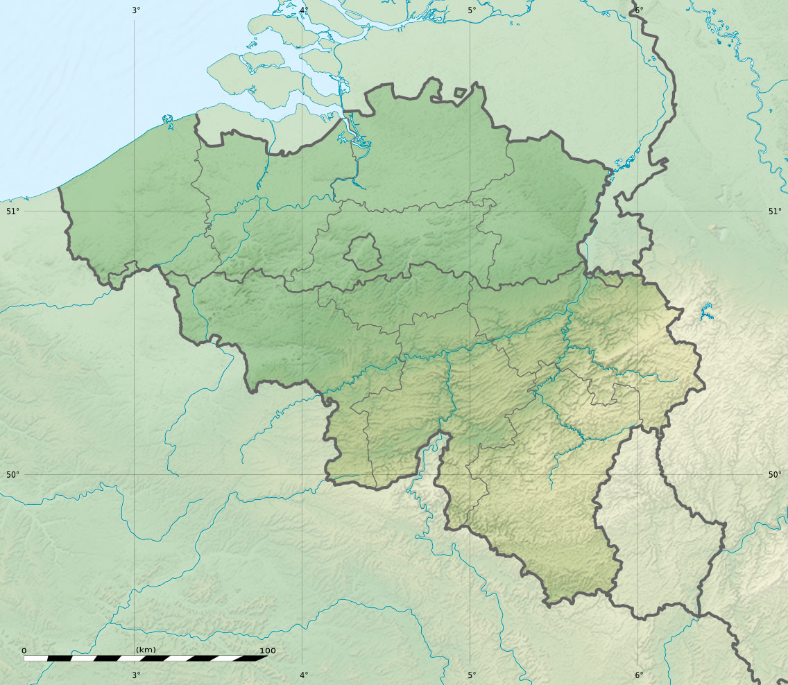
Ghent is located in the middle of an urban area. Brussels to the southeast and Antwerp to the northeast are both about 50 km away, while Bruges, Kortrijk and Roeselare are about 40 km away to the west. The city lies at the confluence of the Scheldt and the Leie. Ghent has a population of 262,219 as of 1 Jan 2019, with an area of 156.18 km², and a population growth rate of 0.6%.
Inhabitants
The metropolitan region of the city has an area of approximately 1205 km². It is home to 594,582 people (1 Jan. 2008), making the Ghent metropolitan area the fourth most populated in Belgium. The central agglomeration has 278,457 inhabitants, the closest surrounding area (banlieue) increases the number to 423,320. With the outermost residential and influence zone (forensenwoonzone) the number adds up to 594,582.
City centre
The city centre is divided into several nuclei dating back to earlier settlements, the difference between the historic medieval centre in the so-called "Wanne" (De Kuip) and the much higher area of the former Saint-Peters Abbey on the Blandinberg is particularly noticeable.
Climate
The city's climate is influenced by the nearby North Sea; daytime temperatures are usually pleasant in both summer and winter: night frosts are just as rare as midday temperatures of over 30 °C.
City breakdown
Overview
Today, Ghent does not only consist of the historical, densely built-up and inhabited city centre, consisting of the centre sitting in the "tub" and the abbey quarter on the Blandinberg. As in many other cities, around the original city area there are quarters that were built in the 19th and 20th centuries as working-class districts; here, too, there is a dense development. To the south lies the railway station district of the early 20th century. Beyond there begins the outskirts of the city, where development has taken place mainly along the major arterial roads, increasingly integrating the surrounding village centres. The city of Ghent is divided into 25 districts, which coincide with historical quarters and neighbourhoods, especially in the centre. Beyond that, the administrative division into sub-municipalities essentially coincides with the socio-cultural and historical division.
Since the mergers of 1965 and 1977, Ghent consists of the following sub-municipalities:
| # | Name | Area | Population |
| I | Gent |
| 112.831 |
| II | Mariakerke |
| 11.558 |
| III | Drongen |
| 12.213 |
| IV | Wondelgem |
| 12.327 |
| V | Sint-Amandsberg |
| 21.567 |
| VI | Oostakker |
| 13.457 |
| VII | Desteldonk |
|
|
| VIII | Mendonk |
|
|
| IX | Sint-Kruis-Winkel |
|
|
| X | Ledeberg |
| 7.955 |
| XI | Gentbrugge |
| 19.812 |
| XII | Afsnee |
|
|
| XIII | Sint-Denijs-Westrem |
| 6.755 |
| XIV | Zwijnaarde |
| 6.918 |
Neighboring communities
Ghent borders the following sub-municipalities:
- Wachtebeke (Wachtebeke municipality),
- Zaffelare (Lochristi parish),
- Lochristi, with the village Hijfte (municipality Lochristi)
- Destelbergen (Community of Destelbergen)
- Heusden (municipality of Destelbergen)
- Melle (Community of Melle)
- Merelbeke (Community of Merelbeke)
- Zevergem (municipality of De Pinte)
- De Pinte (Community of De Pinte)
- Sint-Martens-Latem (Municipality of Sint-Martens-Latem)
- Sint-Martens-Leerne (municipality of Deinze)
- Vosselare (Municipality of Nevele)
- Landegem (municipality of Nevele)
- Merendree (Nevele parish)
- Vinderhoute (Municipality of Lovendegem)
- Lovendegem (Municipality of Lovendegem)
- Evergem, with the villages Belzele and Wippelgem (municipality of Evergem)
- Kluizen (Municipality of Evergem)
- Ertvelde, with the village of Rieme (municipality of Evergem)
- Zelzate (Community of Zelzate)

Related articles
Author
AlegsaOnline.com Ghent — Belgian city, port, and cultural center Leandro Alegsa
URL: https://en.alegsaonline.com/art/38635
Sources
- statbel.fgov.be : Werkelijke bevolking per gemeente op 1 januari 2007 / Population de droit par commune au 1 janvier 2007 (.xls)
- statbel.fgov.be : Geografische coördinaten van de gemeenten (.xls)