Georgia (U.S. state)
Georgia is a southeastern U.S. state founded as a British colony in 1732. Its capital and largest city is Atlanta. The state features coastal plains, piedmont, and mountains and has a diverse economy and culture.
Georgia is a state in the southeastern United States. Established in 1732 as the last of the Thirteen Colonies, it was named for King George II of Great Britain. Today it is known for its varied landscapes—from Atlantic coastal beaches and marshes to rolling piedmont and the mountains of the north—and for Atlanta, its capital and largest city. Georgia is commonly called the Peach State and is also a regional center for commerce, transportation and culture.![]()
Geography and environment
Georgia stretches from the Atlantic coast in the east to the Appalachian foothills in the north and shares borders with Florida, Alabama, Tennessee, North Carolina and South Carolina. Major rivers include the Savannah and the Chattahoochee; coastal features include barrier islands, tidal marshes and estuaries. The state contains several distinct physiographic regions: the Coastal Plain, the Piedmont plateau, and the Blue Ridge and Ridge-and-Valley areas. The climate is generally humid subtropical, though higher elevations experience cooler temperatures.![]()
History and development
Founded as a British colony in the early 18th century, Georgia played a role in the American Revolutionary era and later joined the United States. It ratified the U.S. Constitution in the 1780s. In the 19th century Georgia was a largely agrarian society and was one of the states that seceded during the Civil War. After the war, the state underwent Reconstruction and economic transformation, including industrialization in some regions and significant urban growth during the 20th century. Atlanta emerged as a major transportation hub and center for business, media and higher education.![]()
Economy and infrastructure
Georgia's economy is broad: traditional agriculture (notably peaches, peanuts and pecans) remains important in parts of the state, while urban areas are dominated by finance, technology, manufacturing, film production and logistics. The Port of Savannah is one of the busiest container terminals on the U.S. East Coast, and Hartsfield–Jackson Atlanta International Airport is a major global hub. Transportation corridors, interstates and rail networks link the state regionally and nationally.
Culture, education and society
Georgia has a rich cultural history that includes important roles in the civil rights movement and in American music traditions. It is home to major universities, cultural institutions, professional sports teams and notable historic districts. Southern cuisine, festivals, and college athletics are prominent parts of public life. Demographically the state is diverse, with urban growth concentrated around Atlanta and longstanding rural communities across the rest of the state.
Notable features and quick facts
- Capital and largest city: Atlanta (major center for business, aviation and culture).
- Major cities: Augusta, Columbus, Savannah, Macon, and Athens (a university town).
- Natural attractions: Okefenokee Swamp, the coastal islands and historic Savannah, the Blue Ridge Mountains.
- State symbols: commonly called the "Peach State"; state motto emphasizes wisdom, justice and moderation.
- Distinctive aspects: a mix of coastal and inland economies, significant role in transportation and logistics, and a central place in modern Southern history.
Georgia combines historical landmarks and natural variety with contemporary economic importance. Its cities, ports and transportation hubs link the state to national and international networks, while its cultural and natural sites draw tourism and sustain regional identity.
Geography
Geographical position
The north of the state is located in the Blue Ridge Mountains. The highest point of the state is the Brasstown Bald (1458 m). The length of the coast on the Atlantic Ocean is 161 km.
Extension of the national territory
Georgia has a longitude of 370 km in the west-east direction between 81°W to 85°53'W and a latitude of 480 km in the north-south direction between 30°31'N to 35°N.
Neighbouring countries
Georgia borders the Atlantic Ocean to the east, the state of South Carolina to the northeast, the states of North Carolina and Tennessee to the north, the state of Alabama to the west, and the state of Florida to the south.
The border with South Carolina is formed, starting at the Atlantic Ocean, by the Savannah River - up to the point where the Tugaloo River and Seneca River join to form the Savannah River. West of this, the Tugaloo forms the boundary between Georgia and South Carolina. The Chattooga River, a tributary of the Tugaloo, forms the further border with South Carolina. The Savannah River is dammed at several reservoirs, particularly in its upper reaches. Originally, the river's valley path formed the border between Georgia and South Carolina, but due to the damming of the lakes, this is no longer recognizable in many places. The border with South Carolina is the only Georgia border formed solely by bodies of water, and was established in 1797 in the Treaty of Beaufort.
In the northeasternmost county, Rabun County, the border with North Carolina begins, running strictly westward from there along the 35th parallel. This northern border of the state of Georgia is formed approximately half by the border with North Carolina, the other half by that with Tennessee, which was a territory of North Carolina until independence. To the northwest, Georgia borders directly on Chattanooga. A little farther west the border makes a sharp turn to the south. To the west of the border is Alabama. In the northern half the boundary runs in a straight line south-southeastward until it reaches the Chattahoochee River at West Point, which henceforth forms the boundary in the southern half. This is also the boundary between two time zones: Georgia is on Eastern Time, Alabama is on Central Time.
The southern boundary with Florida extends eastward from the confluence of the Flint River and Chattahoochee River (which continues southward on the Florida side as the Apalachicola River). At first the border is straight, in the east it follows the course of the St. Mary's River into the Atlantic Ocean.
Structure
Georgia is divided into 159 counties. Thus, Georgia is the state with the second highest number of counties after Texas with 254 counties.
→ Main article: List of counties in Georgia
Natural monuments
The National Park Service designates Georgia as having one National Scenic Trail, one National Historic Trail, one National Recreation Area, one National Seashore, and three National Heritage Areas:
- Appalachian Trail
- Trail of Tears
- Chattahoochee River National Recreation Area
- Cumberland Island National Seashore
- Arabia Mountain National Heritage Area
- Augusta Canal National Heritage Area
- Gullah/Geechee Cultural Heritage Corridor
In addition, there are eleven National Natural Landmarks (as of September 30, 2017).
Cultural monuments
Georgia is home to three National Monuments, one National Military Park, one National Battlefield Park, two National Historic Sites, and one National Historical Park:
- Fort Frederica
- Fort Pulaski
- Ocmulgee
- Chickamauga and Chattanooga National Military Park
- Kennesaw Mountain National Battlefield Park
- Andersonville National Historic Site
- Jimmy Carter National Historic Site
- Martin Luther King Jr. National Historical Park
In addition, there are 49 National Historic Landmarks and 2141 structures and sites listed on the National Register of Historic Places (as of September 30, 2017).


Population
Georgia has a population of 9,687,653 as of 2010, of which 55.9% are white, 30.5% are African American, 8.8% are Hispanic or Latino, 3.2% are Asian American, and 0.3% are Native American. Georgia ranks 9th among the states by population. There are 3,540,690 households in existence.
Religions
The major religious denominations in 2000 were the Southern Baptist Convention with 1,719,484 members, the United Methodist Church with 570,674 persons, and the Catholic Church with 374,185 members.
There are many other denominations, mainly Protestant.
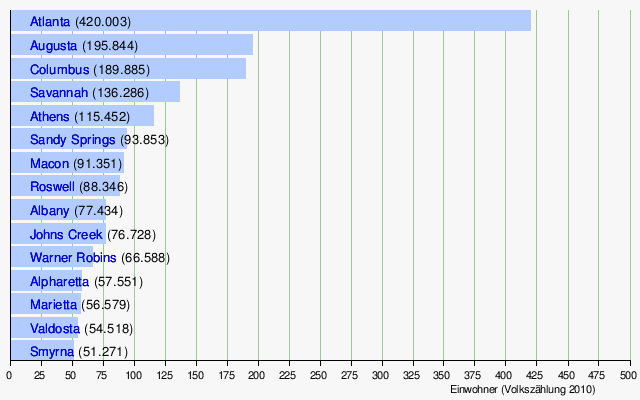
Largest cities
Georgia cities with populations of 50,000 or more, according to the 2010 Census:
- List of places in Georgia
| Population development | |||
| Census | Inhabitants | ± in % | |
| 1790 | 82.548 | - — | |
| 1800 | 162.686 | 97,1 % | |
| 1810 | 251.407 | 54,5 % | |
| 1820 | 340.989 | 35,6 % | |
| 1830 | 516.823 | 51,6 % | |
| 1840 | 691.392 | 33,8 % | |
| 1850 | 906.185 | 31,1 % | |
| 1860 | 1.057.286 | 16,7 % | |
| 1870 | 1.184.109 | 12 % | |
| 1880 | 1.542.181 | 30,2 % | |
| 1890 | 1.837.353 | 19,1 % | |
| 1900 | 2.216.331 | 20,6 % | |
| 1910 | 2.609.121 | 17,7 % | |
| 1920 | 2.895.832 | 11 % | |
| 1930 | 2.908.506 | 0,4 % | |
| 1940 | 3.123.723 | 7,4 % | |
| 1950 | 3.444.578 | 10,3 % | |
| 1960 | 3.943.116 | 14,5 % | |
| 1970 | 4.589.575 | 16,4 % | |
| 1980 | 5.463.105 | 19 % | |
| 1990 | 6.478.216 | 18,6 % | |
| 2000 | 8.186.453 | 26,4 % | |
| 2010 | 9.687.653 | 18,3 % | |
| Before 1900 1900–1990 2000 2010 | |||

Related articles
Author
AlegsaOnline.com Georgia (U.S. state) Leandro Alegsa
URL: https://en.alegsaonline.com/art/38357
Sources
- commons.wikimedia.org : Georgia (U.S. state)
- kff.org : "Median Annual Household Income"