
Geophysics: study of the physical Earth, its structure and environment
Geophysics applies physics to study Earth's interior, surface and space environment. It covers seismic, gravitational, magnetic, electrical and thermal observations used to understand processes, resources and hazards.
Geophysics is the application of the principles and methods of physics to study the Earth and its surrounding space environment. It combines quantitative measurement, physical modeling and observational surveys to infer properties that cannot be seen directly. Modern geophysicists investigate processes ranging from the motion of tectonic plates to the behaviour of the ionosphere, using tools and theory drawn from mechanics, electromagnetism, thermodynamics and fluid dynamics. The field sits at the intersection of physical science and Earth science, translating measurements into models of structure, composition and dynamics. physics of the Earth and its environment in space are central concerns.
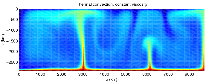
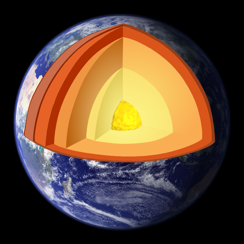
Core targets of geophysical study include rock and crustal structures, mass distribution and the fields that arise from them. Geophysicists commonly address geological problems (geology), the planet's external form (shape), and its gravitational and magnetic field. They probe the internal structure and composition of the crust, mantle and core to explain thermal evolution and convective patterns that drive surface change. This understanding links to large-scale processes such as plate tectonics, the production and movement of magma, and the occurrence of volcanism. Increasingly, studies also encompass the water cycle and cryosphere by measuring snow and ice, and they treat electromagnetic behaviour from near-surface currents to upper-atmosphere electricity and magnetism within the magnetosphere and ionosphere (magnetosphere).
History and development. Although scientific geophysics emerged as a distinct discipline in the nineteenth century, practical and observational roots extend far earlier. Instruments and techniques for sensing Earth processes appear in antiquity; for example, early magnetic compasses and devices to detect ground motion are recorded in ancient history. Later, the application of classical mechanics by figures such as Isaac Newton clarified gravitational influences on ocean tides and axial precession, aiding the study of tides. Over the nineteenth and twentieth centuries researchers developed precise instruments to measure the planet's shape, density and gravity, and to monitor components of the water cycle. In the twentieth century the expansion of electronic sensors, computing and remote methods transformed geophysics and enabled systematic subsurface imaging and global-scale studies.
Image gallery
7 Images


Main methods and subfields
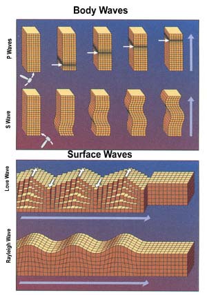
- Seismology: analysis of elastic waves generated by earthquakes or artificial sources to map subsurface structure and locate faults.
- Gravity and geodesy: measurements of gravity and surface deformation that reveal mass distribution, isostasy and crustal motion.
- Geomagnetism and paleomagnetism: study of Earth's magnetic field and its changes through time, important for plate reconstructions.
- Electrical and electromagnetic methods: resistivity, induced-polarization and EM sounding used to detect fluids, minerals and subsurface layering.
- Remote sensing and marine geophysics: satellite and sonar techniques that map topography, gravity anomalies and seafloor features.
- Planetary and environmental geophysics: applying the same physical approaches to other planets and to problems such as groundwater and contamination.
These methods are often combined in multidisciplinary surveys to produce coherent models. Instrumentation ranges from seismometers and gravimeters to magnetometers, GPR and airborne sensors; data processing and inversion transform raw signals into images of structure and physical properties.
Applications, importance and distinctions. Geophysical data are essential for locating energy and raw materials, assessing natural hazards, and managing water and environmental resources. Exploration teams use geophysics to find mineral deposits and hydrocarbon traps, while engineers use surveys to identify subsurface conditions. A geophysical survey can reveal buried archaeological features, map the thickness of glaciers and soils, and detect environmental damage requiring remediation. Geophysics differs from geology in its emphasis on physical measurement and modeling, and from geochemistry in its focus on physical fields and motion, but it complements both to give a fuller picture of Earth processes.
Because it links observation and theory across scales—from local site investigations to planetary dynamics—geophysics is a foundational discipline for understanding Earth's past, managing present resources and anticipating natural change.
Questions and answers
Q: What is geophysics?
A: Geophysics is the physics of the Earth and its environment in space. It involves studying the Earth by measuring things and collecting data, such as its shape, gravitational and magnetic field, internal structure and composition.
Q: When did geophysics become a recognized area of study?
A: Geophysics was only recognized as a special area of study in the 19th century.
Q: Who were some early geophysicists?
A: There were geophysicists in ancient history. The first magnetic compasses were made in the fourth century BC and the first seismoscope was built in 132 BC. Isaac Newton applied his theory of mechanics to the tides and precession of the equinox.
Q: What are some ways that studying geophysics can help with problems?
A: Studying geophysics may help with problems such as mineral resources, reducing natural hazards, and protecting the environment. Geophysical survey data can help find petroleum reservoirs, mineral deposits, groundwater, and archaeological relics. Such data can also tell which areas have environmental damage that should be fixed.
Q: What instruments are used to measure aspects of Earth's environment?
A: Instruments are developed to measure aspects of Earth's environment such as its shape, density and gravity field, as well as parts of the water cycle. In addition modern instruments are used for remote exploration of both solid earths and oceans.
Q: How does geophysics relate to other sciences like astronomy or meteorology?
A: Geophysics studies how electricity and magnetism affect atmospheres like ionosphere or magnetosphere; it also studies how earth interacts with sun which relates to astronomy; it also studies hydrological cycle including snow/ice which relates to meteorology
Related articles
Author
AlegsaOnline.com Geophysics: study of the physical Earth, its structure and environment Leandro Alegsa
URL: https://en.alegsaonline.com/art/38154
Sources
- agu.org : "Our Science"
- iugg.org : "About IUGG"
- agu.org : "AGUs Cryosphere Focus Group"
- earthquake.usgs.gov : "The Early History of Seismometry (to 1900)"
- ngs.noaa.gov : "Geodesy for the Layman"
- csr.utexas.edu : "GRACE: Gravity Recovery and Climate Experiment"
- history.agu.org : "Web resources in the history of geophysics"
- ui.adsabs.harvard.edu : 2003RvGeo..41.1012H
- doi.org : 10.1029/2002RG000114
- books.nap.edu : "Telluric currents: the natural environment and interactions with man-made systems"
- ui.adsabs.harvard.edu : 1968Sci...161..680M
- doi.org : 10.1126/science.161.3842.680
- pubmed.ncbi.nlm.nih.gov : 17801458
- anquetil.colorado.edu : "Heat flow from the Earth's interior: Analysis of the global data set"
- doi.org : 10.1029/93RG01249