
Geography of Nepal: mountains, valleys, rivers and climate
Overview of Nepal’s physical and human geography, major regions, rivers, climate zones, biodiversity, hazards, and significance for culture, economy, and conservation.
Nepal is a narrow, north–south oriented country in South Asia that stretches roughly 800 km along the Himalayan chain and varies from about 150 to 250 km in width. Covering approximately 147,181 km², it is slightly larger than the U.S. state of Arkansas and is landlocked between India on three sides and the Tibetan Plateau to the north, part of China. Its compact shape concentrates dramatic vertical relief: the plains at a few tens of metres above sea level rise to Mount Everest and other summits above 8,800 m.
Image gallery
7 Images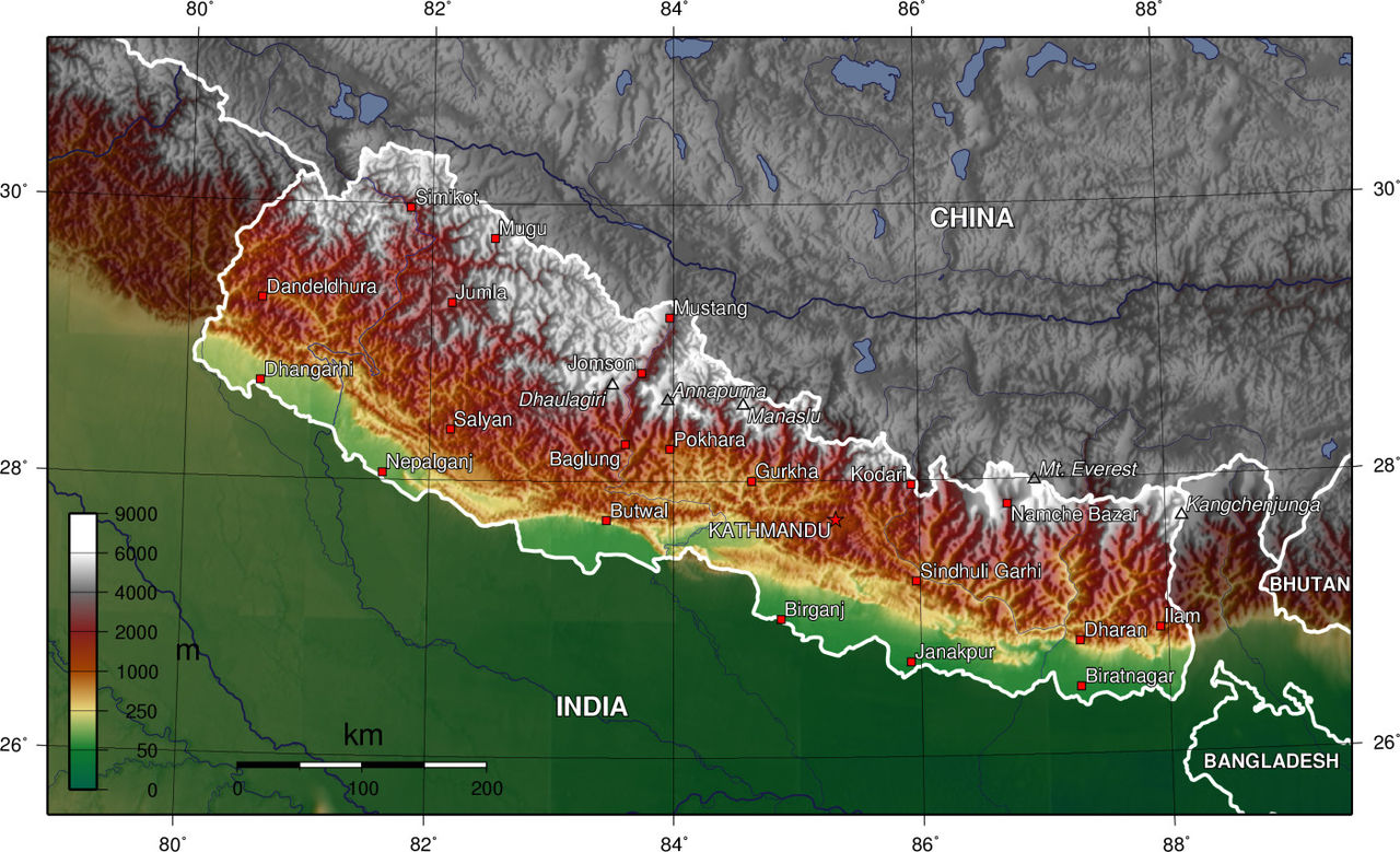



Major physical regions
Nepal is commonly described in terms of distinct altitudinal belts that determine climate, vegetation and land use. From south to north these are:
- Terai – flat, fertile river plains bordering India where most lowland agriculture and much of the population are found;
- Hills – undulating country of terraces, valleys and mid-elevation towns, including the Kathmandu Valley;
- High Mountains and Himalaya – steep, glaciated valleys and the world’s highest peaks, including Mount Everest.
Rivers, drainage and landforms
Major river systems such as the Koshi, Gandaki and Karnali originate in the high mountains and flow south into the Ganges basin in India. These rivers create fertile floodplains, support irrigation and hold major hydropower potential. Glaciers and seasonal snowmelt feed lakes and streams; moraines and steep valley walls are common in the uplands.
Climate, ecosystems and biodiversity
Climate ranges sharply with altitude, from humid subtropical conditions in the Terai to alpine and nival zones above the tree line. The South Asian monsoon brings most annual rainfall in summer, shaping agricultural cycles. Nepal lies within several biodiversity hotspots and contains a wide range of ecosystems—tropical wetlands, temperate forests, subalpine rhododendron stands and alpine meadows—supporting high species richness and many endemic plants and animals.
Human geography, administration and significance
Population is unevenly distributed, concentrated in the Terai plain and hill valleys, notably the Kathmandu Valley, which is the political and cultural capital. Under the 2015 constitution the country is organized into seven provinces and numerous districts. Geography underpins livelihoods—subsistence and commercial agriculture in lowlands, tourism and mountaineering in the mountains, and expanding hydropower projects.
Hazards, conservation and notable facts
Nepal faces natural hazards tied to its geology and climate, including earthquakes, landslides, floods and glacial lake outburst floods (GLOFs). Deforestation, soil erosion and the impacts of climate change on glaciers are ongoing environmental concerns. Notable geographic facts include that Nepal contains eight of the world’s fourteen peaks above 8,000 m and that its steep gradients create outsized potential for hydroelectric energy and nature-based tourism—both key elements of the national economy and conservation planning. For further regional context see materials on the United States and comparative maps of neighbouring regions such as Tibet.
Questions and answers
Q: What is the size of Nepal in terms of its Himalayan axis?
A: Nepal measures about 800 kilometers along its Himalayan axis.
Q: How wide is Nepal across?
A: Nepal is 150 to 250 kilometers wide.
Q: What is the total area of Nepal?
A: Nepal has a total area of 147,181 square kilometers.
Q: Which state in the United States is Nepal slightly larger than?
A: Nepal is slightly larger than the state of Arkansas in the United States.
Q: Which countries border Nepal?
A: Nepal is landlocked by India on three sides and China's Tibet Autonomous Region to the north.
Q: What is the length of Nepal's Himalayan axis?
A: Nepal's Himalayan axis is about 800 kilometers long.
Q: Which country is located to the north of Nepal?
A: China's Tibet Autonomous Region is located to the north of Nepal.
Related articles
Author
AlegsaOnline.com Geography of Nepal: mountains, valleys, rivers and climate Leandro Alegsa
URL: https://en.alegsaonline.com/art/38132