
Geocaching — GPS-based outdoor treasure hunting
Geocaching is an outdoor recreational activity that uses GPS coordinates to hide and seek containers called geocaches. It combines navigation, exploration, and community-driven challenges.
Geocaching is an outdoor recreational activity and hobby that uses satellite navigation (GPS) or mobile devices to locate hidden containers called geocaches or caches. Participants, often called geocachers, search for coordinates published online, sign a physical logbook inside the cache, and usually log their experience on a website or app. Caches range in size and difficulty and may be placed in parks, urban areas, and remote landscapes.
Image gallery
10 Images



How it works
At its simplest, geocaching follows a few basic steps:
- Find published coordinates and a description on a geocaching listing service or app.
- Navigate to the coordinates using GPS or maps, applying map-reading and observational skills.
- Locate the cache container, sign the logbook, and follow any listed rules (take/replace trade items, log online).
- Record the find or a "did not find" (DNF) on the listing so others know the cache's status.
Common cache types and objects
- Traditional cache: a single container at the listed coordinates.
- Multi-cache: several stages that lead to a final container.
- Puzzle/mystery: requires solving clues to get coordinates.
- Micro/macro: sizes vary from tiny containers to large boxes.
- Trackables: items such as travel bugs or geocoins that move between caches and are logged online.
History and development
Geocaching began in 2000 after improvements in GPS accuracy made public satellite navigation practical for recreational use. Enthusiasts quickly organized online to publish coordinates and share finds. Over the following decades the activity grew worldwide; millions of caches have been placed and a large global community participates in hide-and-seek events, challenges, and conservation projects.
Etiquette, safety and legal considerations
Responsible geocaching emphasizes respect for private property, local laws, and the environment. Common guidelines include obtaining permission to place caches, avoiding damage or concealment methods that could alarm the public, following park rules, and practicing "Cache In — Trash Out" (CITO) by removing litter when visiting sites. Safety precautions include telling someone your plans, carrying appropriate supplies, and being cautious in remote or hazardous locations.
Community, education and benefits
Beyond the hunt, geocaching fosters community through meetups and events, can support outdoor education and navigation skills, and encourages exercise and exploration. Teachers and groups use caches for lessons in geography, teamwork, and problem solving. For more information and to find listings, consult official resources and community sites that host cache listings and guidelines.


History
The beginnings
Geocaching can be traced back to the much older letterboxing, in which containers are also hidden in various places, but which are then usually searched for without GPS support. The search is based on clues and a compass. In the container is a special stamp, with which one notes the find in his personal stamp book. Letterboxing is known to have existed in Dartmoor in southern England as early as 1854 and is still very popular there.
Since the 1980s, the Nuuksion Metsäsissit also practiced scavenger hunts in the Helsinki area using only a map and an accuracy of 10 meters, in which containers with various contents were hidden. They then gave the coordinates they had found to acquaintances who could use them to go on a treasure hunt. From the 1990s, the GPS signal was used for the first time to improve the accuracy of the coordinates.
Start of the modern scavenger hunt
It was not until the U.S. government shut down the artificial degradation of the accuracy (Selective Availability) of the GPS signal for non-military users on May 2, 2000 that it was increased from about 100 meters to about 10 meters, making the use of GPS devices in private operations practical. To celebrate this improvement, Dave Ulmer proposed on May 3, 2000, in the Usenet newsgroup sci.geo.satellite-nav, under the title "The Great American GPS Stash Hunt", to start a worldwide game of hiding bins with exchange objects and a logbook at special locations. As rules he formulated "Get some Stuff, Leave some Stuff" - "Take stuff out, leave stuff" and the keeping of a logbook, in which the finders can sign in and document the exchange of objects.
The first geocache
On May 3, 2000, Ulmer buried a black plastic bucket near the city of Portland in the U.S. state of Oregon at 45° 17′ 27.6″ N, 122° 24′ 48″ W45.291-122.413333, in which he deposited CDs, a videocassette, a dollar bill, a book, a slingshot, and a can of beans. He then posted the coordinates of the hiding place on the newsgroup. Within a day of posting, the stash (English for "secret hiding place," "secret lair") was the first to be found by Mike Teague. Three days later, he created a private website documenting the growing number of stashes and their coordinates.
Ulmer's original stash was later badly damaged and no longer exists in its original form. To commemorate it, a new geocache and memorial plaque were placed at the same location in 2001. During the preparations for the cementing of the memorial plate, the old tin can was found on site, which had been an exchange item in the first stash. In the meantime it is shown as a travel bug at geocaching events.
On May 30, 2000, the term geocaching was first proposed in a newsgroup to avoid negative associations of the word stash. On September 2, 2000, Jeremy Irish announced in this newsgroup that he had created his own website for listing geocaches under the address Geocaching.com. This took over all previous entries from the old site, which Mike Teague could not continue to update due to time constraints.
Worldwide distribution
According to the database of the now largest geocache directory Geocaching.com, there are over 3 million active geocaches worldwide today. There is at least one hidden geocache in almost every country in the world. Exceptions are currently North Korea, Somalia and Equatorial Guinea. The only active one outside of the earth is on the International Space Station (ISS).
The USA has the most geocaches with over 1 million (as of September 2017). Germany has over 427,000 geocaches, Austria over 54,000 and Switzerland over 37,000. The fewest geocaches are in North Korea and Somalia with 0 each.
In January 2007, the Nordic countries Sweden, Norway, Finland and Denmark had the highest geocache per capita distribution.
Germany
The first geocache in Germany was hidden by geocacher Ferenc south of Berlin in Brandenburg on October 2, 2000. It was named First Germany and is now archived. With about 61,800 pieces, most geocaches are currently located in Bavaria. The highest geocache density is about 5.7 geocaches/km² in Berlin (as of May 2021). In absolute numbers, Germany is the country with the highest number of geocaches after the USA.
Austria
Austria's first was hidden on June 30, 2001 and was named Austria's First. It too has since been archived (it is commemorated today by a newly published geocache at the same coordinates). With over 13,950, most geocaches can be found in Lower Austria; Vienna has the highest geocache density of about 6.5 geocaches/km² in Austria with over 2,670 geocaches (as of May 2021).
Switzerland
There are currently around 37,000 geocaches in Switzerland (as of May 2021), most of them in the agglomeration areas of the Central Plateau and around the cities. The oldest still active geocache in Switzerland from 27 January 2001 is Gstaad in the Wispile ski area.

The Geocache
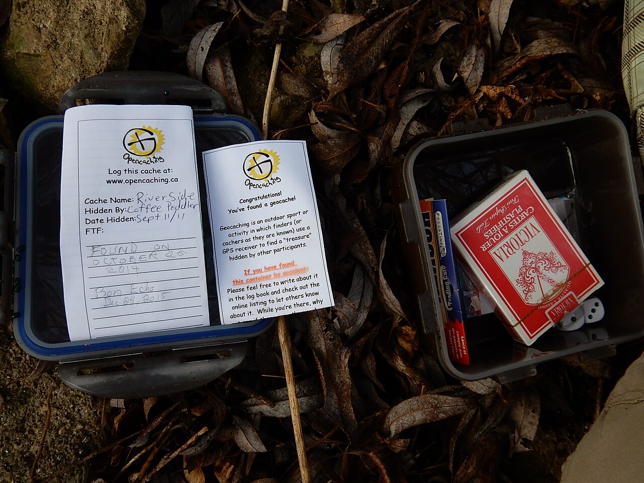
A geocache is ideally a solid, watertight container that can protect the contents from external influences. The container itself can have different forms, from a small film can to a simple plastic freshness box or Tupperware to a steel ammunition box or a hidden safe, the combination of which must first be found out. Often the size of the container is determined by the location of the hiding place. The following size classification has been established for geocache containers:
Nano
Tiny container, usually less than 1 cm in diameter, containing only a small note as a logbook. Often magnetic, so that it can be hidden inconspicuously on monuments or similar. Nanos are a sub-type of micro geocaches, according to Geocaching.com. Nevertheless, some geocache owners choose to use the size designation "Other" for nanos and then provide more details about the size in the listing. At opencaching.de "Nano" is a separate cache size.
Micro or Mini
Very small containers, often containing only a note and pen. Film cans or PET blanks ("PETlings") are often used.
Small
Small containers that provide space for smaller items in addition to a log book.
Normal
Medium sized geocache that has room for several trackables or swap items. Containers of this size can hold from one to several liters.
Large
Large containers that offer maximum space and can therefore hold exceptional barter items.
The owner specifies the size of the geocache when creating the listing. When searching for geocaches, it is helpful to know the size of the geocache, because depending on the specified size, possible hiding places can be excluded.
In addition to the logbook, the container usually contains exchange items. If a geocache was found, the finder can take one or more of the contained items and deposit something else in exchange. This exchange (trading) is then noted in the logbook and on the associated website. There is no obligation to trade; in some geocaches (for example the size Mikro) there is no possibility for this due to lack of space. However, the principle of trade up, trade equal, or don't trade always applies; that is, the items taken and brought in should be in a similar value relationship. If the value of the items taken significantly exceeds that of the items left behind, this is known as downtrading or downtrading and is largely frowned upon - as opposed to uptrading or uptrading, which is leaving behind an item of higher value to be exchanged. If one has nothing suitable to barter, it is a good idea to refrain from bartering. Likewise, it does not make sense to leave food, otherwise perishable goods or, for example, time-limited vouchers, as some caches are rarely found and food attracts animals. Since families with children also go on "treasure hunts", items without youth clearance are also taboo.
Every geocache should include some sort of "instruction manual" (stash note) as basic equipment, so that any chance finders know what the container is about and thus don't see it as trash or a threat.


Questions and answers
Q: What is geocaching?
A: Geocaching is an outdoor sport activity based on GPS where players use a receiver or mobile device and other navigational techniques to hide or look for containers, called "geocaches" or "caches".
Q: What is the main idea of geocaching?
A: One of the main ideas of geocaching is putting caches in places that are interesting, but not often visited by tourists.
Q: What kind of information is given in the listing of the cache?
A: In the listing of the cache, information about the places where the caches are hidden is given.
Q: How many active geocaches are there after 19 years of geocaching?
A: After 19 years of activity, there are over 3,000,000 active geocaches.
Q: How many geocachers are there worldwide?
A: There are over 5 million geocachers worldwide.
Q: What do geocachers use to participate in geocaching?
A: Geocachers use a receiver or mobile device and other navigational techniques to participate in geocaching.
Q: What are the containers called in geocaching?
A: The containers in geocaching are called "geocaches" or "caches".
Related articles
Author
AlegsaOnline.com Geocaching — GPS-based outdoor treasure hunting Leandro Alegsa
URL: https://en.alegsaonline.com/art/38087
Sources
- geocaching.com : "Geocaching"
- geocaching.com : "Geocaching - The Official Global GPS Cache Hunt Site"