Gelsenkirchen
Gelsenkirchen is a city in Germany's Ruhr region, known for its coal-and-steel past, large football club FC Schalke 04, and ongoing economic and cultural redevelopment.
Gelsenkirchen is a city in western Germany. The name is pronounced in regional variants; see the UK pronunciation and the US pronunciation renditions. Administratively it belongs to Germany and lies within the federal state often referred to as North Rhine-Westphalia, sometimes abbreviated NRW.
Image gallery
10 Images


Location and population
Gelsenkirchen sits in the western German industrial belt and is counted among the cities of the Ruhr. It lies roughly 63 kilometres north of Cologne—about 39.1 miles—and is part of the densely populated Ruhr Area. The city has a population of about 269,000 people and functions as a regional centre for housing, local commerce and transport.
History and industrial development
Gelsenkirchen grew rapidly during the 19th and early 20th centuries when the discovery and exploitation of coal, together with the rise of iron and steel manufacturing, turned the Ruhr into one of Europe's major industrial regions. The city's development was closely tied to coal mining and heavy industry; mines, railways and steelworks shaped its urban form and social life for decades. Many neighbourhoods, public buildings and local institutions date from this period of intensive industrial growth.
Economic change and regeneration
From the late 20th century onward, Gelsenkirchen faced the same structural shifts as other Ruhr towns: mine closures and factory downsizing prompted efforts to diversify the economy. Urban regeneration projects have converted former industrial sites into business parks, cultural venues and green spaces. Higher education, logistics, renewable energy projects and small-to-medium enterprises now play an increasing role in the city’s economy.
Culture, sport and civic life
Culture and sport are prominent in local life. Gelsenkirchen is widely known for its football club, FC Schalke 04, which attracts fans from across the region and beyond. The city also supports museums, theatres and festivals that address both its industrial heritage and contemporary arts. Community organisations and initiatives promote social renewal and the preservation of industrial monuments.
Features and practical information
Key points of interest and practical characteristics include:
- Former industrial sites redeveloped as cultural or business locations and public parks.
- A network of tram and regional rail connections linking Gelsenkirchen to other Ruhr cities and the wider state.
- Local neighbourhoods that reflect different eras—workers’ housing from the 19th century, postwar residential districts and modern developments.
- Ongoing civic projects that balance heritage conservation with economic renewal.
For visitors and researchers, Gelsenkirchen offers a concentrated example of the Ruhr’s transition from heavy industry to a diversified post‑industrial economy, while retaining strong local identity through sport, culture and community life.
UK pronunciation • US pronunciation • Country • State • NRW • 63 km • 39.1 mi • Cologne • Ruhr Area • Coal mining • FC Schalke 04

Geography and climate
Location and area
Gelsenkirchen is located on the flat slopes of the broad Emscher valley with the Rhine-Herne Canal running parallel here in the southwest of Westphalia. The core city lies south of the river or canal, while the districts of Horst and seven districts that emerged from Buer lie north of the waters. As a result of subsidence, a large part of the city lies below the main receiving watercourse Emscher and must therefore be constantly protected from flooding by the Emschergenossenschaft with drainage pumps.
The largest extension of the city area is 17 kilometers in the north-south direction and 11 kilometers in the west-east direction. The city boundary has a total length of 68 kilometers.
In Gelsenkirchen, about ten per cent of the urban area is park and leisure land and 25 % is woodland and agricultural land. Gelsenkirchen is thus one of the cities with an above-average proportion of green spaces.
Gelsenkirchen is located in Germany's largest polycentric conurbation, the Rhine-Ruhr metropolitan region.
Neighboring communities
The following cities border the city of Gelsenkirchen clockwise, starting in the east: The independent cities of Herne, Bochum and Essen as well as the cities of Gladbeck, Dorsten, Marl and Herten, which belong to the district of Recklinghausen.
Exklave Gelsenkirchen owns an exclave of about two hectares at the point where the Hüll stream forms the city boundary between Bochum and Herne. This belongs to the district Ückendorf.
City breakdown
See also: Districts in Gelsenkirchen
The urban area of Gelsenkirchen consists of five city districts, each with a district council, which are subdivided into city districts. The boroughs with associated districts:
- Gelsenkirchen-North: Buer, Scholven, Hassel
- Gelsenkirchen-Mitte: Old Town, Bismarck, Bulmke-Hüllen, Feldmark, Heßler, Schalke, Schalke-Nord
- Gelsenkirchen-West: Horst, Beckhausen
- Gelsenkirchen East: Erle, Resse, Resser Mark
- Gelsenkirchen-South: Neustadt, Ückendorf, Rotthausen
The borders between the city districts, with the exception of the border of the North district, form various elements of the city's transport infrastructure. For example, the Herne-Oberhausen railway line separates the central and southern districts, the Rhine-Herne Canal separates the central and western or eastern districts, and the Kurt-Schumacher-Strasse separates the eastern and western districts.
The smallest share of the industrially and commercially used area of the city of Gelsenkirchen today is in the districts South with about 7.8 % (or 9.11 % in relation to the district area) and East with 8.9 %. On the other hand, the industrial past can still be seen in the district Mitte with a share of 37 % measured in terms of the industrially used city area (or 16 % in relation to the district). In the North and West districts, the figures of 31 % and 15 % (in relation to the industrially used urban area) reflect the large amount of land used by the BP refinery plants there.
The three districts North, East and West are equally heavily used for agriculture with about 20 % of the respective district area, whereby 42 % of all agriculturally used areas of the city are located in the district North alone. Bringing up the rear are the Central and South districts with only 5% and 11.9% respectively of the district area. Forestry land use is highest in the East district (where the Resser Mark forest area is located) with 14 %. In relation to the entire urban area, as much as 40 % of all forestry land is located in the East district.
While a certain agricultural and forestry character is noticeable, especially in the north and east of the town and in the district of Beckhausen, the town's mining past with its associated residential buildings is particularly noticeable south of the Rhine-Herne Canal, even though only a few buildings remain as reminders of the Holland, Rhine-Elbe and Hibernia collieries and the cast steel works (now the Science Park) that were once operated there.
Districts vs. parishes
The three city districts north, west and east of the Emscher largely correspond to the old Amt Buer in the Vest or district of Recklinghausen minus the offices of Gladbeck (split off in 1885, today the city of Gladbeck) and Westerholt (independent in 1911; since 1975 a district of Herten). Horst also left the Amt Buer in 1891, but was united with the city of Buer in 1928 with Gelsenkirchen, after Horst had already sought the connection to Buer for economic reasons. Within the three northern city districts, there are only the municipalities of Horst (5128) and Buer; within the latter, all other districts north of the Emscher (as well as that part of the BP Öl site which is part of today's Horst district).
South of the Emscher river the following municipalities exist:
- Heßler
- Bismarck
- Schalke
- Gelsenkirchen
- Bulmke covers
- Rotthausen
- Ückendorf
The new district Schalke-Nord is not, as the name would suggest, mainly located on Schalker territory, but occupies mainly the north-east of the Heßleraner and the west of the Bismarck territory. It justifies its name mainly by the Schalker railway station and the Glückauf-Kampfbahn in its south, which, however, have always been on Heßleraner territory.
The new district Feldmark occupies the northwest of the Rotthausen area, the southwest of the Schalk area and, to a lesser extent, the south of the Heßler area. The inhabitants of the district live for the most part on old Schalker territory, since the essential part of the part taken over from Rotthausen is occupied by the harness racing track and the Zollverein slagheap.
The city centre, meanwhile divided into Alt- and Neustadt, grew to the west somewhat into the Rotthausen district, but in the north a much larger part was ceded to Schalke. Ückendorf took over some areas in the north from the now united Bulmke and Hüllen, which in turn took over areas in the north from Bismarck.

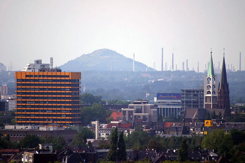
enlarge and show information about the picture
![]()
City panorama Gelsenkirchen: Old town from the Hamburg-Mannheimer building.

enlarge and show information about the picture
![]()
City panorama Gelsenkirchen: From the Arena to Ückendorf
Climate diagram
| Gelsenkirchen | ||||||||||||||||||||||||||||||||||||||||||||||||
| Climate diagram | ||||||||||||||||||||||||||||||||||||||||||||||||
| ||||||||||||||||||||||||||||||||||||||||||||||||
| Monthly average temperatures and precipitation for Gelsenkirchen
Source: DWD, data: 2015-2020 | ||||||||||||||||||||||||||||||||||||||||||||||||||||||||||||||||||||||||||||||||||||||||||||||||||||||||||||||||||||||||||||||||||||||||||||||||||||||||||||||||||||||||||||||||||||||||||||||||||||||||||||||||||||||||||||||


History
Middle Ages and early history
Although today's district of Buer was not mentioned in a document for the first time until 1003 AD as Puira (presumably an accidental Buira) by Heribert I, there were already some hunting peoples (possibly Germanic Bructerians) on the hill north of the Emscher in the Bronze Age, i.e. more than a thousand years before Christ, who did not live there in settlements, but in closely spaced individual farms. Later, the Romans penetrated the region. Around 700 AD the area was settled by the Saxons. Some other districts, which today are located in the northern part of Gelsenkirchen, were already mentioned in the early Middle Ages; some examples are Raedese (today the district of Resse), Middelvic (Middelich; today belonging to the district of Resse) or Sutheim (Sutum) and Sculven (today the district of Scholven). Many Bauerschaften were later localized with the designation iuxta Bure (near Buer).
Around 1150 the name Gelstenkerken or Geilistirinkirkin appeared for the first time. The first spelling translates as church at the settlers (-seten) in the quarry land (gel). The second variant was translated by Franz Darpe as church (at the brook) of the luscious bulls and by Paul Derks as church at the place where horny bulls romped. The named church probably referred to the Gelsenkirchen village church, one of the predecessor buildings of the church of St. George. However, the patron saint St. George has nothing to do with the first part of the city's name. At about the same time, the first church was built in the north of today's city area in the district of Buer; this ecclesia Buron (church at Buer) was listed in 1160 in a directory of parish churches by the Deutz sexton Theodericus. The settlement belonged to the Vest Recklinghausen. However, in early times and in the Middle Ages only a few dozen people lived in the settlements around the Emschermulde. On the other hand, the areas south of the Emscher River belonging to the present-day city of Gelsenkirchen belonged to the County of Mark, which had been part of Brandenburg-Prussia since 1666 (provisionally from 1609).
From 1609 to 1706, 15 people were affected by witch hunts in the area of today's city of Gelsenkirchen. Anna Spiekermann, born in Gelsenkirchen-Buer (Bauerschaft Sutum), was executed in Westerholt on 31 July 1706. She was the last victim of the witch hunts in the Vest Recklinghausen.
In the witch trials in the Freiheit Horst (Gelsenkirchen-Horst) 14 persons were put on witch trials, six were executed. In 1609 the children Greitgen Nothoff, Johann Nothoff and the 8-year-old Trina Nothoff were expelled from the dominion. Their parents Johann Nothoff and Hille Nothoff were strangled and then burned.
Industrialization
Until the middle of the 19th century, the area in and around Gelsenkirchen was sparsely populated and almost exclusively agricultural. In 1815, the present-day urban area of Gelsenkirchen - after temporarily belonging to the Grand Duchy of Berg - passed to Prussia, which annexed it to the province of Westphalia. While the then Gelsenkirchen was assigned to the Wattenscheid district in the Bochum district of the Arnsberg administrative district, the Buer district (with Horst) was assigned to the Recklinghausen district in the Münster administrative district. This assignment to two administrative districts did not end until 1928.
After the discovery of hard coal in 1840 and the industrialization that followed, the main line of the Cologne-Minden Railway Company and the first Gelsenkirchen railway station were opened in 1847. In 1868 Gelsenkirchen became the seat of its own office in the district of Bochum. This included the communities of Gelsenkirchen, Braubauerschaft (from 1900 Bismarck), Schalke, Heßler, Bulmke and Hüllen. Friedrich Grillo founded the Aktiengesellschaft für Chemische Industrie and the Schalker Gruben- und Hüttenverein in Schalke in 1872. One year later, also in Schalke, he founded the Glas- und Spiegel-Manufaktur AG. After Gelsenkirchen had become an important location for heavy industry, it was granted city status in 1875.
Gelsenkirchen becomes a big city
In 1885, after the division of the Bochum district, Gelsenkirchen became the seat of its own district, which was to exist until 1926. The district of Gelsenkirchen included the towns of Gelsenkirchen and Wattenscheid as well as the Braubauerschaft (from 1900 Bismarck), Schalke, Ückendorf and Wanne districts. A few years later, on 1 April 1897, Gelsenkirchen left the district of Gelsenkirchen and became a district-free city. Horst left the district of Buer in 1891.
The irresponsibility of the water supply operators led to the typhus epidemic in Gelsenkirchen in 1901.
On 1 July 1907, Gelsenkirchen's main railway station was opened because the old station no longer had sufficient capacity due to the strong increase in population. In the course of industrialisation, many Polish-speaking workers had moved from the province of Posen, who in 1905 made up 13.9% of Gelsenkirchen's urban population. Buer was elevated to the status of a town in 1911 and one year later became a district-free municipality; Westerholt, which until then had belonged to the Amt Buer, became the seat of its own office. In 1924, the rural municipality of Rotthausen, which until then had belonged to the district of Essen, became part of the city of Gelsenkirchen.
The Deutsche Reichsbahn-Gesellschaft built the Gelsenkirchen-Bismarck depot from 1924 to 1926, which was in operation until 1981. In the course of the Prussian territorial reform, the towns of Gelsenkirchen and Buer were merged with the district of Horst to form the new independent town of "Gelsenkirchen-Buer" on 1 April 1928. Since then, the entire city area has belonged to the administrative district of Münster. In 1930 the name Gelsenkirchen-Buer was changed to Gelsenkirchen by the city council with effect from 21 May. The city was now home to about 340,000 people in the new constellation.
Gelsenkirchen at the time of National Socialism
During the National Socialist era, Gelsenkirchen was one of the centres of the armaments industry due to its location in the heart of the Ruhr area. In the mid-1930s, Hibernia AG built the Scholven hydrogenation plant as a subsidiary, where synthetic gasoline was produced by coal liquefaction. In the same year, 1936, Gelsenkirchener Bergwerks-AG founded Gelsenberg Benzin AG in Horst and produced petrol from coal there from 1939. Today, both plants belong to BP Gelsenkirchen. At no other time was the production of the Gelsenkirchen industry so high. On the one hand, this briefly created more jobs in mining and heavy industry again - after many jobs had been rationalised away in the 1920s. On the other hand, Gelsenkirchen became a target for Allied bombers during the Second World War, when three quarters of the city area were destroyed in the air raids on the Ruhr area. Even today, many former high bunkers can still be found in the cityscape. Next to the town hall in Buer, an air raid shelter is still partly preserved in its original condition; in the course of the gutting of the Hans-Sachs-Haus, the remains of the bunker there were removed.
Although the football club FC Schalke 04 adapted to the political circumstances, it was not active in the National Socialist movement.
Adolf Hitler visited Gelsenkirchen for the funeral services of industrialist Emil Kirdorf, which took place in July 1938 on the grounds of the Rheinelbe colliery in Gelsenkirchen-Ückendorf.
In Gelsenkirchen, too, the synagogue in the Buer district was burned down by the National Socialists in November 1938, and the synagogue in downtown Gelsenkirchen was also destroyed. Exactly 66 years later, the foundation stone was laid there for the new Gelsenkirchen synagogue, which was inaugurated on 1 February 2007.
In Gelsenkirchen-Horst there was a subcamp of the Buchenwald concentration camp in 1944. The Gelsenberg camp on the premises of Gelsenberg Benzin AG housed about 2,000 Hungarian women and girls who were assigned to forced labor at the hydrogenation plant. About 150 of them were killed in the bombing raids on Gelsenberg Benzin AG on September 11, 1944. They were forbidden access to bunkers and protective trenches.
The surgeon Rudolf Bertram, who was in charge of the hospital in Rotthausen and the St.-Josefs-Hospital in Gelsenkirchen-Horst from 1937 onwards, is known to have saved 17 severely injured Jewish women from being transported to the Buchenwald concentration camp in Sömmerda, who had been taken to Gelsenkirchen hospitals after the bombing raids. Through the efforts of Bertram and many other hospital employees, these women and girls experienced their liberation in April 1945 in the Rotthauser Marienhospital. For this act of humanity, Bernhard Rudolf Bertram was posthumously awarded the distinction Righteous Among the Nations by the Israeli memorial Yad Vashem in 1980. Bertram remained chief physician at St.-Josefs-Hospital until his retirement in 1965 and died in Gelsenkirchen in 1975. In 1996, a stele with a commemorative plaque was erected in his honour in front of the St.-Josefs-Hospital in Gelsenkirchen-Horst to commemorate the events. The square in front of the hospital was named Rudolf-Bertram-Platz.
The area north of the Rhine-Herne Canal was occupied by the US Army at the end of March. The part of Gelsenkirchen south of the canal was not occupied until April 10, 1945. Elsewhere in Germany, the war continued until early May. The Second World War finally ended on 8 May with the unconditional surrender of the Wehrmacht. Today, the documentation site "Gelsenkirchen under National Socialism" is located at Cranger Str. 323 in the Erle district.
Postwar
After the extensive destruction of the city and its industry during the Second World War, the Hassel coking plant went into operation on 17 December 1953 as Germany's first new coking plant after the war.
With the introduction of postal codes in 1961, Gelsenkirchen was one of a few cities to receive two postal codes: Gelsenkirchen 465 and Buer 466 (both in use until 1 July 1993). The first comprehensive school in NRW was established in Gelsenkirchen in 1969. Scholven-Chemie AG (formerly Hydrierwerk Scholven) merged with Gelsenberg-Benzin-AG in 1975 to form VEBA-Oel AG.
Gelsenkirchen was an important location for the clothing industry. This was once one of the five supporting pillars of the local economy. The steep rise began in the 1950s and 1960s, this is also shown by the former station window, which can be seen today at the foot of Bahnhofstraße. Around 50 companies, such as Kemper KG, Nienhaus & Luig, Marcona, Harald Feigenhauer, Hugo Kogge, Napieralla & Söhne, Schreck and Witschel&Markmann provided work for over 6000 employees in the early 1950s. In 1958, short-time work initially began and five companies were forced to close. At the beginning of the 1970s, further companies fell victim to the oil crisis and the resulting almost unaffordable synthetic fibres.
Between 1979 and 1981, the Heinze women became known nationwide. The employees of a photography company in Gelsenkirchen won the same pay as their male colleagues in court.
During his visit to the Federal Republic of Germany, Pope John Paul II celebrated a Holy Mass in the Park Stadium in front of 85,000 people on 2 May 1987. He accepted the honorary membership in FC Schalke 04 offered to him.
Until well into the time of the coal and steel crises, there were and still are large manufacturing companies from this industrial sector in Gelsenkirchen, including the Schalker Eisenhütte Maschinenfabrik, which still exists today, and the cast steel works of Thyssen AG.
In the 1990s, the restructuring of the economy and the city itself became visible in Gelsenkirchen - later than in some other cities in the Ruhr region. In 1997, for example, the Federal Horticultural Show (BUGA) took place on the site of the disused Nordstern colliery, transforming the former colliery site into a landscape park. Two years later, the finale of the cross-city IBA Emscher Park, which began in 1989, took place.
The Hassel coking plant produced coke for the last time on 29 September 1999. With the shutdown, the last coking plant on Gelsenkirchen's municipal territory ceased production. Until then, coke had been produced in Gelsenkirchen for 117 years and 12 days. In the same year Shell Solar Deutschland AG started the production of photovoltaic plants. With the closure of the last colliery in Gelsenkirchen, the Ewald Hugo colliery, 3000 miners were dismissed on 28 April 2000.
The district of Buer celebrated its 1000th anniversary in 2003 and FC Schalke 04 its 100th anniversary on 4 May 2004.
In 2015, Gelsenkirchen hit the headlines in the Youth Welfare Office scandal because of personal entanglements between the management of the Youth Welfare Office and a children's home in Hungary.
City Films
Between 1951 and 1996, the city of Gelsenkirchen regularly produced annual chronicles on film, 34 of which have been preserved and are also available in digital form. The city films documented the political, cultural and social development of Gelsenkirchen.
Religions
Confession statistics
According to the 2011 Census, 33.7% of residents were Roman Catholic, 30.1% were Protestant, and 36.3% were non-denominational, belonged to another religious community, or did not specify. The number of Protestants and Catholics has since declined and, at 49%, those not belonging to any legally constituted religious community are almost the majority of the population. Currently (as of March 31, 2021), of the residents, 27.7% are Catholic, 22.9% are Protestant, and 49.4% are non-denominational or have some other denomination.
Judaism
→ Main article: Judaism in Gelsenkirchen
There is a Jewish community in Gelsenkirchen, which has grown in recent years due to the influx of a larger number of emigrants from the Soviet Union or the Russian Federation. Today the Jewish community of Gelsenkirchen has about 400 members. During the Night of Broken Glass, Nazis destroyed Jewish shops, homes and cemeteries throughout the German Reich and set fire to synagogues. The synagogue in Gelsenkirchen, which had been consecrated in 1885, also burned to the ground. Since 1963, a memorial plaque commemorated the destruction of the old synagogue. Finally, in 1993, the site was renamed the Square of the Old Synagogue and 66 years later, on November 9, 2004, Paul Spiegel laid the foundation stone for the new synagogue. On February 1, 2007, the building was ceremoniously opened. The new centre of the Jewish community was built on the site of the old synagogue, which was destroyed in 1938. The prayer room offers space for a total of 400 worshippers, and a community centre with an event room is also attached.
Christianity
Of the residents (as of December 31, 2016), 85,002 (30.6%) were Catholic. At the end of 2018, only 80,027 of the inhabitants were Catholic.
As a foundation of Essen, Gelsenkirchen had from the beginning the same ecclesiastical conditions as the mother church in Essen itself, i.e. the church belonged to the Archbishopric of Cologne and was subordinate to the Deanery of Essen. With the transfer to the county of Mark, the Gelsenkirchen parish priest was subordinate to the dean of Wattenscheid. The churches in Buer and Horst were assigned to the dean of Dorsten. In Gelsenkirchen, the Reformation according to the Lutheran confession prevailed at the beginning of the 17th century, but the Catholics were still able to share the use of the only church in the town (St. Georg, today the Altstadtkirche) until the end of the 19th century (Simultan church). At the beginning of the 17th century a Reformed congregation was also established. The proportion of Protestants and Catholics in Gelsenkirchen was relatively balanced. Buer and Horst remained Catholic as places of the Vest Recklinghausen. It was not until the 19th century that Protestant parishes were established here as well. However, the proportion of the total population never exceeded one third.
Gelsenkirchen's Protestant parishes belonged to the Bochum Synod until the end of the 19th century, but in 1892 the city became the seat of its own superintendent or district synod for the entire surrounding area. This later gave rise to the church district of Gelsenkirchen and Wattenscheid, to which 22 Protestant parishes of the city of Gelsenkirchen and the neighbouring district of Wattenscheid of the city of Bochum belong today within the Protestant Church of Westphalia. The northern Protestant congregations consist of Buer with 8900 members, Markus-Gemeinde Hassel with 1950 and Scholven with 3350 members. They intend to merge into one large congregation in 2007.
The Catholics in Gelsenkirchen were able to use the church of St. George together with the Protestants until the middle of the 19th century. As a result of the strong growth of the community, however, the construction of a church of their own was necessary. So in 1845 the Augustinuskirche was built. Because it was soon too small, however, the present St. Augustine's Church was built between 1874 and 1884, which was elevated to the status of a provost church by papal decree in 1904. In 1905, 47.3% of the inhabitants of Gelsenkirchen were Protestant and 51.2% Catholic.
The Provost Church became the mother church of several other Catholic churches in the city. Heavily destroyed by bombs during the Second World War in 1944, the Augustinuskirche was rebuilt from 1948 to 1952 and has since been restored several times. The parishes of Gelsenkirchen belonged to the (arch)diocese of Paderborn from 1821. The city became the seat of a deanery. The parishes in Buer and Horst belonged to the diocese of Münster from 1821. While Buer became the seat of its own deanery, Horst belonged to the deanery of Gladbeck. In 1955 the parish church of Sankt Urbanus in Buer became a provost church. When the diocese of Essen was founded in 1958, all the parishes of the city of Gelsenkirchen became part of this new diocese. Today they form the city deanery of Gelsenkirchen.
Both the Protestant and Catholic churches operate a number of large social institutions in Gelsenkirchen, especially in the health sector. These include, among others, the Protestant clinics in the centre of Gelsenkirchen and the headquarters of St. Augustinus Gelsenkirchen GmbH in Ückendorf, which runs the Marienhospital there, as well as the St.-Vinzenzhaus (nursing home for the elderly) and the St.-Josefsheim (children's home) in Gelsenkirchen-Mitte and, located in the centre of Buer, the Catholic St.-Marienhospital. There are also Orthodox parishes in Gelsenkirchen.
The Evangelical Free Churches in Gelsenkirchen include: an Evangelical Free Church congregation (Baptists), a congregation of the Evangelical Methodist Church, a corps of the Salvation Army and the Christ congregation belonging to the Mülheim Association.
As a result of the community movement, numerous regional church communities were also formed in many parts of Prussia at the end of the 19th century, parallel to the traditional Evangelical Regional Church. These communities usually belong to the Evangelical Regional Church and hold their own events in addition to church services. Here, for example, the city mission is to be mentioned. The Evangelical Lutheran Prayer Communities (ELG), which belong to the regional church but are otherwise independent, also experienced a special spread. Many of these communities still exist today. In Gelsenkirchen alone there are four communities, the ELG Gelsenkirchen-Middelich, Erle, Hüllen and Ückendorf.
The New Apostolic Church and the Apostolic Community are also represented in Gelsenkirchen. The New Apostolic Church has 15 congregations in Gelsenkirchen. The apostolic community offers one congregation.
In addition to their local congregations, Jehovah's Witnesses operate a congress hall in Gelsenkirchen-Erle, where supra-regional meetings of the religious community are held on a regular basis.
Islam
Furthermore, Islamic communities are represented. The Islamic religious communities have gradually emerged through immigration, especially the Turkish guest worker families (in the 1960s). In 2006, the proportion of Muslims in the total population of Gelsenkirchen was 20%. In the Hassel district there has been a classical mosque since the 1990s, and there are now 20 mosques in Gelsenkirchen (as of January 2018). In 2001, the mosque Kesselstraße 25-27 was built. There were fierce disputes between the district office and the mosque association with its (2005) 280 members. The association was accused of cooperating with the Islamic community Millî Görüş, which is observed by the Office for the Protection of the Constitution.
Incorporations
The urban area of Gelsenkirchen has developed as follows:
Incorporation 1903:
- Bismarck (until 1900 Braubauerschaft) - until 1868 to the office Wattenscheid, district Bochum, then to the office Gelsenkirchen, district Bochum, from 1877 to the office Schalke, district Bochum and from 1887 own office in the meanwhile newly founded district Gelsenkirchen
- Schalke - until 1868 to the office Wattenscheid, district Bochum, then to the office Gelsenkirchen, district Bochum, from 1877 own office, which came 1885 to the district Gelsenkirchen
- Heßler - until 1868 to the office Wattenscheid, district Bochum, then to the office Gelsenkirchen, district Bochum, from 1877 to the office Schalke, all 1885 district Gelsenkirchen
- Bulmke - until 1868 to the office Wattenscheid, district Bochum, then to the office Gelsenkirchen, district Bochum, from 1877 to the office Schalke all 1885 district Gelsenkirchen, from 1887 Bulmke to the office Braubauerschaft/Bismarck
- Hüllen - until 1868 to the office Wattenscheid, district Bochum, then to the office Gelsenkirchen, district Bochum and 1877 to the office Schalke, all 1885 district Gelsenkirchen, 1887 Hüllen to the office Braubauerschaft/Bismarck
- Ückendorf - until 1876 to the office Wattenscheid, district Bochum, then own office, which came from 1885 to the district Gelsenkirchen
Incorporation in 1924 and 1926:
- 1924: Rotthausen - until 1873 to the mayoralty Altenessen, district Duisburg, then to the mayoralty Stoppenberg, district Essen and from 1906 own mayoralty in the district Essen
- 1926: Parts of Röhlinghausen and Wanne
Merger 1928:
- Merger of the independent cities of Gelsenkirchen and Buer with the district of Horst (which belonged to the district of Buer until 1891, then became an independent district) to form the new independent city of Gelsenkirchen-Buer on 1 April 1928.
On 21 May 1930 the name of the town was changed to Gelsenkirchen.
Population development
→ Main article: Population development of Gelsenkirchen
In 1903, after the incorporation of Schalke (26,077 inhabitants in 1900), Ückendorf (21,937), Bismarck (21,169), Bulmke (11,001), Heßler (3508 inhabitants in 1895) and Hüllen (2969 inhabitants in 1895), the population of Gelsenkirchen exceeded 100,000, making it a large city. In 1924 Rotthausen (29,413 inhabitants in 1919) was incorporated, raising the population to 206,595.
On April 1, 1928, the population of the city grew to 340,077 after the merger of the cities of Gelsenkirchen (207,153 inhabitants in 1925) and Buer (99,307) and the municipality of Horst-Emscher (23,412). In 1959, the population reached its historic high of 391,745. Since then, the population has dropped by almost 35%. On 31 December 2011, 257,994 people lived in the city with their main residence, according to the update of the State Office for Data Processing and Statistics of North Rhine-Westphalia. For 2025, the population forecast of the state office assumes only 226,100 inhabitants. Real estate prices have developed in line with the number of inhabitants; vacancies are as high as 14,000 apartments.
The extreme population increases since the beginning of industrialisation in the middle of the 19th century (mainly before the First and after the Second World War) can be explained by the workers recruited for the coal and steel industry. These were often Poles and before the Second World War came mainly from East and West Prussia as well as from Posen and Silesia. After the Second World War, the majority of workers came from southern Europe and Turkey. The proportion of foreigners in Gelsenkirchen was 22.6% on 31 December 2020. Within the urban area, considerable differences are evident with regard to the proportion of the foreign population. While the proportion of foreigners tends to be high in the southern and inner-city residential areas, the values in many northern districts are predominantly considerably lower.


Related articles
Author
AlegsaOnline.com Gelsenkirchen Leandro Alegsa
URL: https://en.alegsaonline.com/art/37866