Fürth — city in Bavaria, Germany
Fürth is a mid-sized Bavarian city adjacent to Nuremberg, known for its historic centre, early railway connection, East Franconian dialect, and a long multicultural urban history.
Fürth is a city in Germany, located in the administrative region of Bavaria. It lies immediately west of Nuremberg and forms part of the larger Nuremberg metropolitan area. With a population of about 118,000, Fürth combines a compact historic centre with residential neighbourhoods and light industry, and is often spoken of together with its larger neighbour when describing the region.
Image gallery
10 Images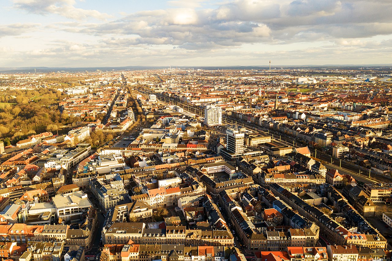


Characteristics and urban fabric
The city preserves a varied architectural mix: a medieval street pattern in parts of the old town, substantial 19th-century and early 20th-century façades from the era of industrial expansion, and post-war development in the suburbs. Local speech belongs to the East Franconian dialect group; the city also has a documented Jewish heritage reflected in historical names such as the Yiddish Fiurda. Municipal services, cultural venues and green spaces serve both residents and the surrounding commuter population.
History and development
Fürth developed from a settlement on trade routes and grew into an important regional market town. Its urban growth accelerated in the 19th century with industrialisation. A landmark moment in German transport history took place here: the first scheduled steam railway on German territory connected Nuremberg and Fürth in the 1830s, establishing the area as an early node in the national rail network and helping shape subsequent economic ties with nearby cities.
Transport and economy
Today Fürth benefits from dense local and regional transport links. Commuter rail and rapid-transit connections integrate it closely with Nuremberg; additional road and bus services support daily travel across the metropolitan region. The local economy mixes services, small and medium enterprises, public administration and cultural industries. Proximity to larger urban centres makes Fürth attractive for households seeking shorter commutes and a compact urban environment.
Culture, institutions and notable facts
The city hosts theatres, museums and markets that reflect Franconian traditions alongside contemporary cultural programming. Annual events and local clubs contribute to civic life. Fürth is often noted for its early railway milestone and for its long-standing multicultural character, with layers of German, Jewish and regional Franconian history visible in its streets and institutions.
- Location: immediate neighbour of Nuremberg, part of the same metropolitan area.
- Population: roughly 118,000 inhabitants.
- Historical note: site of the first scheduled German steam railway connection.

Geography
Location and area
The historic city centre is located east and south of the rivers Rednitz and Pegnitz, which flow together northwest of the old town to form the Regnitz. To the west of the city, beyond the south-west bypass and the Main-Danube Canal, the Fürth city forest rises. To the east of the city lies the directly adjoining city of Nuremberg at about the same altitude. To the north is the fertile Knoblauchsland, which partly belongs to the city area. South of the city lies a mixed area of wide motor roads, canal and river meadows.
The highest point of the terrain is the quarry in Burgfarrnbach with 392.3 m above sea level, the lowest is in the Regnitztal at the city border to Erlangen at 278 m above sea level, the city hall in the city center is at 294.9 m above sea level.
The area of the city area is 63.36 km², the length of the city boundary 50.05 kilometers. The distance between the easternmost and westernmost point of the Fürth city area is 9.835 kilometres, between the northernmost and southernmost point 11.704 kilometres.
Neighboring communities
The following cities and municipalities border the city of Fürth, they are named clockwise starting in the north:
Erlangen and Nuremberg (both district-free), Oberasbach, Zirndorf, Cadolzburg, Seukendorf, Veitsbronn and Obermichelbach (all district of Fürth).
City breakdown
For the division of Fürth into boroughs and districts see: List of city districts and statistical districts of Fürth.
The political municipality has 21 officially designated parts of the municipality (the settlement type is indicated in parentheses):
- Atzenhof (village)
- Bislohe (village)
- Braunsbach (village)
- Burgfarrnbach (district)
- Dambach (district)
- Flexdorf (village)
- Fürth (main town)
- Herboldshof (village)
- Kronach (village)
- Mannhof (Pfarrdorf)
- Oberfürberg (village)
- Poppenreuth (parish village)
- Ritzmannshof (village)
- Ronhof (village)
- Sack (church village)
- Stadeln (district)
- Steinach (village)
- Unterfarrnbach (village)
- Unterfürberg (village)
- Vach (district)
- Weikershof (village)
enlarge and show information about the picture
![]()
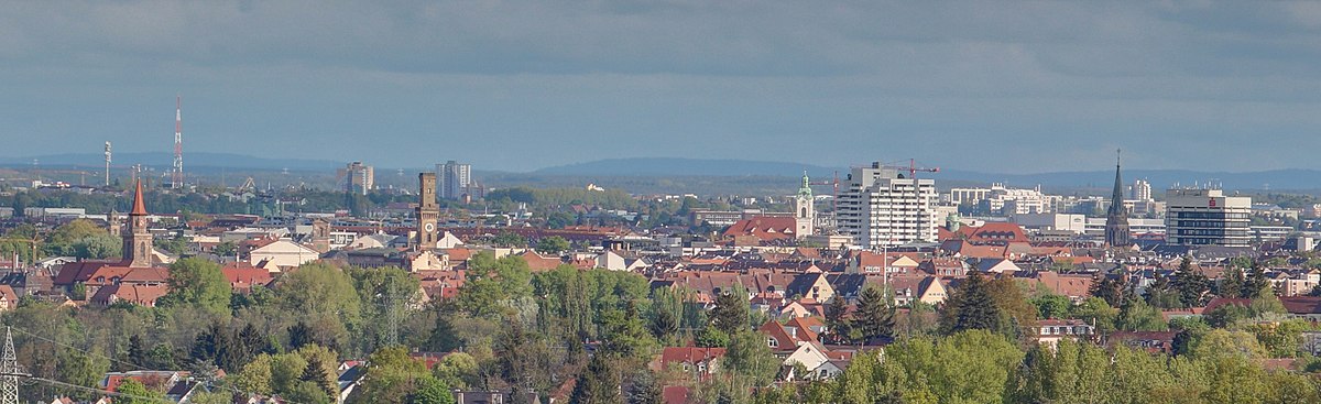
Fürth panorama from the "Solarberg" ( ![]() 49.510310.96232) looking southeast, May 2017. Among others, the church St. Michael and the town hall can be seen in the left part of the picture, the churches St. Heinrich and St. Paul, the high-rise buildings Bahnhofcenter and the Sparkassenhaus, and behind the town hall the two high-rise buildings in the Nuremberg district Röthenbach in the right part of the picture.
49.510310.96232) looking southeast, May 2017. Among others, the church St. Michael and the town hall can be seen in the left part of the picture, the churches St. Heinrich and St. Paul, the high-rise buildings Bahnhofcenter and the Sparkassenhaus, and behind the town hall the two high-rise buildings in the Nuremberg district Röthenbach in the right part of the picture.
Nature
The urban ecology nature trail was established in 1999 (three kilometres, ten stations) and extended in 2003 to include a Route B (seven kilometres, ten stations). The starting point for both tours is the Stadthalle underground station. Along the trail, individual habitats are explained in terms of their importance for flora and fauna (e.g. St. Michael's churchyard, municipal cemetery, Scherbsgraben); reference is made to the designation of certain areas as landscape conservation areas and to the problems associated with measures that alter the environment, such as river straightening. The average sunshine duration is 1766 hours per year.
The Gustav Adolph Spring is located near Weikershof, right on the Rednitz River. It was revived in 2000 and equipped with a pavilion. Until 1953, the spring water with its 19 degree warm water was used in a nearby swimming pool. Since its demolition, the water, 160 litres per minute, flowed unused into the river. Due to the faint smell of hydrogen sulphide, the spring is also called Gaggerlasquelle (Franconian dialect for "egg spring").
The 560-hectare Fürth city forest is home to rare animal species and is therefore a Special Protection Area of European Interest in the Natura 2000 habitat network. The forest consists largely of pines intermixed with deciduous trees. In the quarries in the Fürth city forest, castle sandstone was quarried as an important building material until the Middle Ages. Among others, various bat species (brown long-eared bat, fringed bat and water bat) and the black woodpecker live in the city forest.
→ Main article: Fürth city forest
In Fürth there are thirteen designated landscape conservation areas, one geotope and two designated FFH areas. (as of January 2016)
See also:
- List of protected landscape areas in Fürth
- List of FFH areas in the city of Fürth
- List of geotopes in Fürth


Related articles
Author
AlegsaOnline.com Fürth — city in Bavaria, Germany Leandro Alegsa
URL: https://en.alegsaonline.com/art/37074
Sources
- destatis.de : "Alle politisch selbständigen Gemeinden mit ausgewählten Merkmalen am 31.12.2018 (4. Quartal)" · web.archive.org
- destatis.de : destatis.de/DE/ZahlenFakten/LaenderRegionen/Regionales/Gemeindeverzeichnis/Administrativ/…
- statistikdaten.bayern.de : "Fortschreibung des Bevölkerungsstandes"