
Funnel cloud: rotating condensation that does not touch the ground
A funnel cloud is a rotating, funnel-shaped cloud of condensed water droplets that extends from a cloud base without contacting the ground or water. It can become a tornado or a waterspout if it reaches the surface.
A funnel cloud is a visible, funnel-shaped column of condensed water droplets extending downward from the base of a cloud while remaining detached from the ground or a water surface. The familiar cone or needle silhouette is caused by condensation in a localized, rapidly rotating column of air. Because the condensation funnel itself does not make surface contact, it is distinct from a tornado, although the two are closely related in origin and behaviour. For more on the basic form, see funnel-shaped and on the parent cloud type see cloud.
Image gallery
5 Images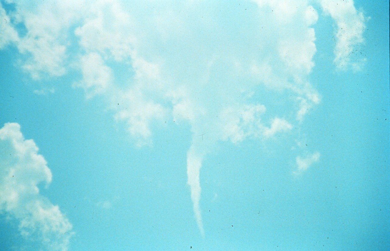




Characteristics and formation
Funnel clouds are usually associated with strong convective storms where vigorous updrafts and vertical wind shear create rotating structures. Typical features include:
- Condensation funnel: a visible column of condensed water droplets formed by cooling and pressure changes in the rotating air; compare with general condensed water.
- Rotational core: an axis of rotation or vortex often embedded within a larger rotating updraft — sometimes identifiable as a rotating column on visual inspection.
- Parent storm: many funnel clouds form in association with organized thunderstorm types such as supercell storms and other strong thunderstorms that support mesocyclones and sustained shear.
From funnel cloud to tornado or waterspout
When a funnel cloud lowers further and makes contact with the ground or lofts debris, the phenomenon is classified as a tornado. Visual confirmation of ground contact is often provided by a debris cloud rather than the condensation funnel itself; official classification and warnings rely on this distinction. If a funnel cloud reaches the surface over water, it is called a waterspout. The transition from funnel cloud to tornado or waterspout depends on several environmental factors including low-level moisture, friction, and the intensity of the vortex.
Types and related terms
Not all funnel clouds lead to violent tornadoes. Meteorologists differentiate among several related phenomena:
- Tornado: a rotating column of air in contact with the ground and the cloud base; see tornado.
- Waterspout: a vortex over water formed either by tornadic processes or by fair-weather mechanisms; see waterspout.
- Landspout and cold-air funnel: generally weaker, short-lived funnels that may develop beneath cumulus clouds without deep mesocyclones.
Observation, detection and safety
Funnel clouds can be visually striking but ephemeral. Modern detection relies on Doppler radar and storm-spotter networks to identify rotating signatures aloft; visual reports from trained observers remain important for confirming surface involvement. For safety, people should treat a visible funnel cloud or radar-indicated rotation as a potential precursor to a tornado and follow local warnings, seek shelter, and avoid exposed locations. Photographers and storm chasers are advised to maintain a safe distance and coordinate with emergency services when observing severe convection.
In summary, funnel clouds are a visible manifestation of rotating air condensed into a column beneath a cloud base. They play a central role in the life cycle of many tornadoes and waterspouts, and understanding their formation and limits helps meteorologists issue timely warnings and the public take protective action. For further visual guides and educational resources see shape references, cloud types, and technical summaries on condensation, rotation, supercells, thunderstorms, tornado classification and waterspouts.
Questions and answers
Q: What is a funnel cloud?
A: A funnel cloud is a funnel-shaped cloud of condensed water droplets that extend from the bottom of a cloud, usually appearing with a rotating column of air.
Q: What do funnel clouds usually look like?
A: Funnel clouds usually appear as a cone or needle-shaped cloud that extends out from the main cloud base.
Q: When do funnel clouds often develop?
A: Funnel clouds often develop when supercell thunderstorms happen.
Q: What happens if a funnel cloud touches the ground?
A: If a funnel cloud touches the ground, it becomes a tornado.
Q: Are all funnel clouds tornadoes?
A: No, many funnel clouds that appear do not actually touch the ground and do not become tornadoes.
Q: How can tornadoes be seen?
A: Tornadoes can only be seen when they pick up stuff off the ground (debris), but one can see them from a distance of many miles.
Q: What is a funnel cloud that makes contact with water called?
A: A funnel cloud that makes contact with water is called a waterspout.
Q: What is a funnel cloud that touches the ground in front of a snow squall called?
A: A funnel cloud that touches the ground in front of a snow squall is called a winter waterspout.
Related articles
Author
AlegsaOnline.com Funnel cloud: rotating condensation that does not touch the ground Leandro Alegsa
URL: https://en.alegsaonline.com/art/37053