Fujian Province, China
Fujian is a coastal province in southeast China known for rugged terrain, diverse Min languages, historic maritime trade ports, tea and tulou earthen houses; parts of its islands are administered by Taiwan (ROC).
Fujian (福建, Fújiàn) is a coastal province on the southeastern shore of China. Its provincial capital is Fuzhou. Fujian's landscape is dominated by steep hills and a long indented coastline; the physical geography, climate and seafaring history have shaped its economy, languages and culture.
Image gallery
10 Images


Geography and natural features
Fujian occupies a narrow, mountainous strip between the sea and interior ranges. The province has extensive coastline and many offshore islets. Important natural highlights include the Wuyi Mountains, known for biodiversity and tea cultivation, and the distinctive circular earthen houses called tulou found in the inland parts.
History, people and languages
Long engaged in maritime trade, Fujian produced influential ports such as Quanzhou and Xiamen that connected China with Southeast Asia and beyond. The province is home to several branches of Min Chinese—most notably Hokkien (Min Nan)—and communities of Hakka speakers. Fujianese migrants have historically formed significant overseas communities throughout East and Southeast Asia.
Economy and cultural importance
Economically, Fujian mixes agriculture (tea, fruit and aquaculture) with modern industries such as electronics, shipbuilding and trade. Cities like Xiamen developed as early zones for foreign investment. Local culture is rich in folk performance, cuisine and religious traditions, and Fujian teas and maritime crafts are widely recognized.
Administrative and political status
Most of Fujian is administered by the People's Republic of China as a provincial-level unit (province). However, a small group of offshore islands—described as some offshore islands—are administered by the Republic of China (Taiwan). Notable examples are Kinmen and Matsu, which lie close to the Fujian coast but have different administrative arrangements yet remain central to cross-strait relations.
Notable places and distinctions
- Fuzhou: provincial capital and administrative center.
- Xiamen and Quanzhou: historic ports and modern economic hubs.
- Wuyi Mountains and Fujian Tulou: landscapes and architectural sites of cultural significance.
- Strong linguistic diversity: multiple Min dialects and Hakka communities.
Fujian's combination of rugged interior, active coastline and long maritime connections has produced a distinctive regional identity within China, visible in language, cuisine, architecture and the global Fujianese diaspora.
Geography
The province is located on the southeast coast of China. With its area of 121,400 square kilometers, the province is slightly larger than the former GDR, but has twice the population. It borders the provinces of Zhejiang to the north, Jiangxi to the west and Guangdong to the southwest. To the east and south are the East China Sea, the South China Sea and the Taiwan Strait. Fujian has strong cultural ties with the island of Taiwan across the Taiwan Strait. Several small islands in the Taiwan Strait belong to Fujian, while the Matsu and Quemoy are controlled by the Republic of China.
Fujian is geographically isolated from the rest of mainland China by several forested mountain ranges, with these ranges running parallel to the coast. Their height increases towards the hinterland, and on the border with Jiangxi lies the Wuyi Mountains, which are the highest elevation in the province at up to 2,100 m above sea level. In total, mountainous land occupies about 90% of the surface area. The coast is very bay- and island-rich, and there is little flat land between the mountainous land and the coast. The relief is described by the people of Fujian with the proverb "八山一水一分田 - bashan yishui yi fen tian", meaning eight parts mountain, one part water and one part field.
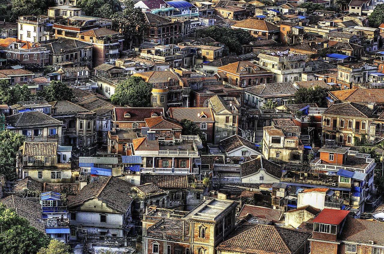
The main settlement area of Fujian with a population density of partly more than 1000 inhabitants per square kilometer is located between the two delta regions of Min River and Jiulong River. Larger cities are Fuzhou, Putian, Quanzhou, Xiamen, Zhangzhou (from north to south on the coast) as well as Nanping, Sanming and Longyan (in the hinterland on a parallel to the coast).
Waters
Due to the topography of the province, almost all rivers originate in the province and also flow into the sea on the Fujian coast. The Wuyi Mountains form the watershed between Fujian and Jiangxi, the Donggong Mountains the watershed between Fujian and Zhejiang. The longest river, the Min River gave the province its short name Min. Other important rivers are the Jiulong River, Ting River, Jin River, Jiao Xi, Ao River, Huotong Xi, Mulan River, Zhaoandong Xi, Zhang River, Qiulu River and Long River. All of them have a catchment area larger than 500 square kilometers. A large number of smaller watercourses originate in the mountains in the center of the province and flow directly into the sea from there. The largest four rivers drain three quarters of the territory of Fujian. Due to the high rainfall climate, Fujian's rivers discharge 116.8 billion cubic meters of water into the sea annually. The largest river, the Min River, accounts for almost half of this.
Most of the water is taken up by the rivers of the province in their upper and middle courses. Since they originate in the rain-rich mountains, they absorb a lot of water here, which leads to frequent flooding in the lower reaches. The annual average discharge in the province is 962 mm, depending on the rainfall it ranges between 500 and 1400 millimetres. Within China, only Taiwan and Guangdong have more annual runoff.
The coast of Fujian Province would be 530 kilometers long in a straight line. However, due to the numerous bays and peninsulas, the coastline is extended many times over to about 3,080 kilometers.
Climate
Fujian Province is characterized by warm humid and subtropical monsoon climate. The average annual temperature is between 17 and 21 °C. The July temperature averages 30 °C on the coast and 10 °C in January; these values are lower in the mountainous areas. Average rainfall ranges from 1,100 to 2,000 mm (1,670 mm provincial average), with the bulk (80-85%) of rain falling between May and September. The western mountainous region receives more rainfall than the coastal regions, and overall Fujian is among the regions with the most rainfall in mainland China. Typhoons occur annually in summer and autumn and cause widespread evacuations, as in September 2005, when 760,000 people had to be brought to safety from Typhoon Talim.


Administrative division
People's Republic of China
Fujian Province is subdivided into nine district-free cities (for detailed information see there):
| Map | # | Name | Administrative headquarters | Hanzi, Hanyu Pinyin | Population (2010) |
|
| |||||
| - Sub-provincial city - | |||||
| 2 | Xiamen | Siming | 厦门市, Xiàmén Shì | 3.531.347 | |
| - District-free city - | |||||
| 1 | Fuzhou | Gulou | 福州市, Fúzhōu Shì | 7.115.370 | |
| 3 | Longyan | Xinluo | 龙岩市, Lóngyán Shì | 2.559.545 | |
| 4 | Nanping | Yanping | 南平市, Nánpíng Shì | 2.645.549 | |
| 5 | Ningde | Jiaocheng | 宁德市, Níngdé Shì | 2.821.996 | |
| 6 | Putian | Chengxiang | 莆田市, Pútián Shì | 2.778.508 | |
| 7 | Quanzhou | Fengze | 泉州市, Quánzhōu Shì | 8.128.530 | |
| 8 | Sanming | Sanyuan | 三明市, Sānmíng Shì | 2.503.388 | |
| 9 | Zhangzhou | Xiangcheng | 漳州市, Zhāngzhōu Shì | 4.809.983 | |
Republic of China
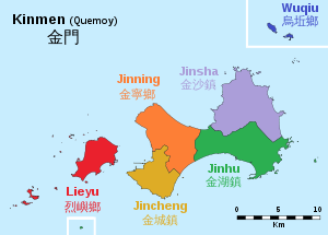
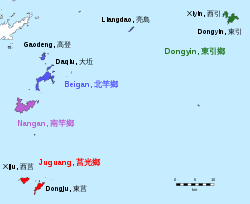
Fujian province consists of two counties: Kinmen and Lienchiang. The total area of the islands is 182.66 km². 71,000 people live on the islands (as of 2001).
| Name | ||
| Chinese | 金門縣 | |
| Map |
|
|
| Islands | 15 islands | 36 islands |
|
| |
| Administrative division | 6 large municipalities | 4 large municipalities |
Questions and answers
Q: What is Fujian?
A: Fujian is a province situated on China's southeast coast.
Q: What is the capital of Fujian?
A: The capital of Fujian is Fuzhou.
Q: Who administers most of Fujian?
A: Most of Fujian is administered by the People's Republic of China.
Q: Which areas of Fujian are under the control of the Republic of China?
A: Kinmen (also called Quemoy) and Matsu are regions of Fujian under the control of the Republic of China.
Q: What does the PRC claim about Kinmen and Matsu?
A: The PRC continues to claim that Kinmen and Matsu are part of Fujian Province.
Q: What is Kinmen?
A: Kinmen is a region of Fujian under the control of the Republic of China.
Q: What is Matsu?
A: Matsu is a region of Fujian under the control of the Republic of China.
Related articles
Author
AlegsaOnline.com Fujian Province, China Leandro Alegsa
URL: https://en.alegsaonline.com/art/36915
Sources
- chinadaily.com.cn : chinadaily.com.cn/bizchina/2008-12/19/content_7323066.htm
- poundsterlinglive.com : "U.S. Dollar to Chinese Yuan Spot Exchange Rates for 2017 from the Bank of England"
- chinamaps.info : "Fujian Demographics - China Maps [Map-Manage-System(MMS)]"
- chamiji.com : "2018年全国各省人口总数排行榜-世界人口大全-2017年 2018年"