
Fontanella (municipality in Vorarlberg, Austria)
Fontanella is a small alpine municipality in the Bludenz district of Vorarlberg, western Austria, known for mountain scenery, traditional rural culture and outdoor recreation.
Fontanella is a mountain municipality in western Austria, located in the district of Bludenz and the federal state of Vorarlberg. It lies within the Austrian Alps and is part of the region administered from the town of Bludenz. As a local community its administration is organized as a municipality within the Austrian federal system and it falls under the jurisdiction of the state government of Vorarlberg.
Image gallery
2 Images

Overview and landscape
Fontanella occupies alpine terrain characterized by steep slopes, mountain pastures and forested areas. The landscape supports mixed uses: seasonal grazing, forestry and tourism. Snow in winter and clear mountain air in summer make the surroundings attractive for outdoor activities, while village settlements and hamlets retain traditional rural building styles.
History and culture
The community's development reflects typical alpine settlement patterns, centered on agriculture, forestry and local crafts. Cultural life emphasizes regional traditions, seasonal festivals and cuisine of western Austria. Local architecture often shows wooden farmhouses and stone foundations adapted to mountainous conditions.
Economy and recreation
Economic life combines small-scale farming, hospitality, and services for visitors. Hiking, mountain biking and winter sports draw recreational visitors; local businesses supply lodging, guiding and mountain services. The municipality maintains trails and public amenities to support both residents and tourists.
Notes and distinctions
- Administratively part of the Bludenz district and the state of Vorarlberg.
- Typical of small alpine municipalities: seasonal tourism complements traditional livelihoods.
- Accessible by regional mountain roads and linked to nearby towns for services.


Geography
Fontanella is the highest mountain village of the "Biosphärenpark Großes Walsertal". 29.5 % of the area is forested, 52.1 % of the area is alpine. Due to its location at the north-eastern end of the Great Walser Valley, the Bregenzerwald village of Damüls can be reached via the Faschinajoch.
Community structure
The municipal area comprises the following seven villages (number of inhabitants as of 1 January 2021 in brackets):
- Faschina (30)
- Fontanella (219)
- Garlitt (10)
- Mittelberg (128)
- Saw (9)
- Seewald (7)
- Türtsch (54)
The municipality consists of the cadastral municipality Fontanella.
History
The village was settled in the 14th century by Walliser colonists who reached this area via Graubünden-Laterns-Damüls and belonged to the Walser court of Damüls. Fontanella was first mentioned in a document in 1363 as "Funtanell". The place name is derived from a Roman word, the diminutive of "fontana" (= well, spring). It was taken from an old healing spring in this area. The "Heilbrünnlein" is said to have been fed by a ferruginous spring. The place came to Austria in 1390 together with the dominion of Feldkirch.
The Habsburgs ruled the towns in Vorarlberg alternately from Tyrol and Vorderösterreich (Freiburg im Breisgau). From 1805 to 1814 the place belonged to Bavaria, then again to Austria. Fontanella has belonged to the Austrian province of Vorarlberg since its foundation in 1861.
From 1945 to 1955 the village was part of the French occupation zone in Austria.
- See also: 1954 avalanche disaster in Vorarlberg
Population development
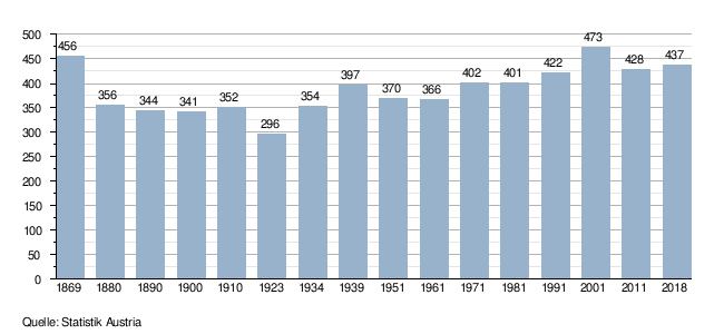
The share of non-Austrian citizens was 5.7 percent at the end of 2002 and 5.0 percent in 2018.
The migration balance has been negative since 1981, but could be balanced by the strongly positive birth balance until 2001. After 2001, the birth rate decreased and emigration increased, resulting in a decline in the number of inhabitants.
Related articles
Author
AlegsaOnline.com Fontanella (municipality in Vorarlberg, Austria) Leandro Alegsa
URL: https://en.alegsaonline.com/art/35428