Terms
In meteorology, fogs are usually distinguished according to their conditions of formation, which means, however, that many fogs cannot be classified as a specific type of fog solely on the basis of their external appearance. There is also a multitude of often very vaguely defined or at least very ambiguously used fog terms, especially if they refer to the place or time of occurrence and not to the cause of origin of a fog. Thus, according to the cause, one essentially distinguishes between radiation, advection, evaporation, mixing and orographic fogs, as well as ice fog as a special form often considered separately. In addition, however, there are a number of other well-known terms such as morning fog, mountain fog or lake fog, which in many cases are difficult to relate to specific conditions of formation and often lead to misunderstandings as to which term stands for which generic type of fog.
It is also possible to distinguish between ground fog and high fog, whereby the top of the ground fog must, according to meteorological definition, be below the eye level of the observer with a visibility of thereby more than one kilometre. It is also possible to define ground fog as fog with ground contact, but this is redundant to the definition of a fog per se. The common understanding of a high fog as a fog with no ground contact is therefore also misleading, since it is usually a low cloud of the stratus type, i.e. not fog in the proper sense. Only in the case of some intermediate stages of fog that have been dissolved at their base or are in the process of descending to ground level, one also speaks in meteorology of a high fog.
Radiation Nebula
Radiation fogs are formed as a result of the nocturnal radiation of the earth's surface and therefore occur mainly in autumn and winter when there is little wind, whereby they are usually associated with a radiation inversion. Since they are based on a cooling of the air with a constant or negligible variation of the absolute humidity, they are also counted among the cooling fogs.
Especially on uncloudy nights, the air layers near the ground can cool down considerably. This causes the water vapour in the air to condense and a weak, often multi-layered fog with a height of hardly more than 100 metres forms, with a comparatively small droplet size. In the morning, this fog usually dissipates quickly, as the high specific surface area of its droplets allows rapid evaporation due to the then increased saturation vapour pressure. Only in winter is the sun's radiation sometimes not strong enough to dissolve the fog. The foggy, dull weather then often persists for days in the lowlands.
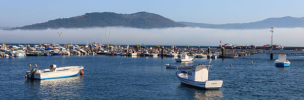
Radiation nebulae are very unstable formations and usually dissipate as quickly as they came. They usually appear as early or morning fog, but their beginnings may well be in the late afternoon of the previous day. Whether or not a radiation fog forms is often a matter of a few tenths of a degree Celsius. The frequency, density and thickness of this type of fog is therefore subject to great fluctuations. The predictability of the phenomenon is therefore comparatively low, even if radiation nebulae are so frequent that a diurnal rhythm can develop. The occurrence of radiation fog is a signal for low temperatures. In particular, cold air pockets in lowlands, e.g. in basins, typically show cut-off fog carpets with sharp contours, which are then also called valley fog or, if very pronounced, sea of fog.
A special form is also formed by bog fogs, i.e. fogs that occur over bogs and therefore have their own name, because the frequency of fogs is particularly high here. The cause is the very rapid cooling of the ground surface due to its high soil moisture and the resulting poor heat conduction properties, not an increase in evaporation due to the large water supply. A bog fog is therefore not an evaporation fog, because the air humidity is usually removed by winds before the fog is formed. However, the formation of fog itself is linked to calm winds and rarely reaches thicknesses that exceed the visibility of an observer. This example shows the great role played by the ground heat balance in the formation of a radiation fog. The same effect can also be observed in a weaker form in meadows, which is why they are also referred to as meadow fog.
With an albedo of up to 0.90, nebulae generally exhibit an extraordinary ability to reflect incoming sunlight. This usually contrasts sharply with its surroundings, with an albedo of typically about 0.2 to 0.3. The consequence, especially in the case of radiation nebulae, is a tendency towards self-preservation, because the low temperatures that led to its formation in the first place are further lowered or prevented from rising by the now rapidly falling global radiation. Also, the radiation of the water droplets themselves is particularly large, which results in a nightly temperature minimum at the top of the nebula.
In the case of stable stratification of the atmosphere at ground level and inversion at altitude, i.e. fumigation, particles of various kinds accumulate at the inversion boundary. With its high albedo, this haze at some height can now not only maintain fog, but even generate it. The fog, at first still strictly speaking a cloud and sometimes referred to as high fog, gradually descends from the height of the inversion to the ground and often lasts for days.
Advection Nebula
Advection fog or contact fog is another form of cooling fog that usually occurs in Central Europe in winter and is based on the advection of air masses. The distinction from mixing fog can be difficult under certain circumstances, but here all forms of fog that are decisively characterised by advection and partly also by mixing processes are to be counted among the advection fogs.
Advection fogs are caused by moist warm air flowing from the south into the colder areas in the north and stirring up a layer of cold air close to the ground. The warm air is cooled in the process, which is why condensation occurs and droplets form. If a high-pressure situation then develops, this fog can last for days to weeks without being able to be dissolved by the sun. Only with a further air exchange it disappears again, because it is not only the longest lasting fog form, also thicknesses of several hundred meters are not rare.
A special case of advection fog is coastal or sea fog. The water surfaces are usually much cooler than the land surfaces, especially in spring. If advection of the warm air masses over the land then occurs, these cool down quickly over the water. The water droplets formed after reaching the dew point are then deposited as a thin layer of fog over the water surface, which is then also referred to as cold water fog. In Germany, this type of fog is most common in late spring at the Baltic Sea and is caused by the advection of warm air from southern Europe. This form of fog is particularly consequential when a warming inland leads to sea breezes during the day. The fog, which actually lies above the water, is then advected to the coasts and can reach several kilometres inland. Such a coastal fog intrusion is characterised by a considerable change in visibility and temperature conditions and also occurs extremely suddenly, so it can lead to considerable dangers, especially in road traffic. In addition, due to the comparatively small droplet sizes of coastal fog, a considerable reduction in brightness is to be expected. The situation of still quite warm water temperatures and comparatively cold air, which can be found especially in autumn, leads to warm water fog, which is usually dominated by mixing processes, which is why it tends to be classified as a mixing fog.
Likewise, ocean currents of different temperatures can lead to advection fog, provided that the air flows from the warm to the cold water surface. This phenomenon, called sea fog, can be seen in Newfoundland, for example, when the Labrador Current comes into contact with the Gulf Stream. The very well-known Newfoundland Nebula is one of the most persistent and dense fogs at all. In the Aleutian Islands, this type of fog also occurs more frequently due to the contact of the Oyashio and Kuroshio ocean currents.
Fog also frequently forms in upwelling areas, for example with the California Current, the Humboldt Current or the Benguela Current. Finally, a last form is formed by an air current directed towards inland ice masses, mostly from the sea. Here, the air masses also cool down and Greenland fog is formed, for example. To a lesser extent, this effect is also seen in less extreme contrasts, for example in the case of an irregular onset of snowmelt.
Orographic fog
Mountain fog, or in its meteorologically exact designation orographic fog, forms when moist air rises on slopes under adiabatic cooling. It is therefore also counted among the cooling fogs, but the cooling occurs here due to the reduction of air pressure and not via radiation or advection. This type of fog only occurs when the condensation level is below the summit or ridge. Stable orographic fogs exist everywhere where an equally stable wind flow constantly brings air masses to a mountain range, although one can then also speak of an advection fog. This is mainly the case in regions with trade wind influence, for example in the southern Andes or in Madagascar. They also occur in the Alps and German low mountain ranges, but then mostly only in individual weather conditions over short periods.
The formation of an orographic fog is in principle identical with a cloud formed by uplift and one could therefore also speak of an uplift fog. Lifting processes do not only occur at orographic obstacles, but only there the earth's surface rises with it and thus enables a surface-bound condensation. Nevertheless, this definition is more general and in special cases, fog formation can also occur elsewhere. This is the case, for example, with small-scale convections, as they play a role in mixing fogs. Lifting processes during the passage of a warm front can also cause short-term fog events.
Evaporative mist
In contrast to the previous forms of fog, which were all associated with cooling, evaporative fog is a type of fog that is caused by an increase in the absolute humidity of the air and thus the dew point. This is achieved by increased evaporation, while the temperature of the air parcel remains constant or changes only insignificantly.
In nature, this occurs mainly in warm autumnal lakes, and is then called a steam fog (also river fog or lake fog at sea, or lake smoke or sea smoke). Also when humid air of moderate temperatures passes over a snow cover or frozen ground and increases the evaporation rate due to its warming, such a type of fog can develop. This special form is called thaw fog.
A special form is the frontal fog, which mainly forms as a narrow fog strip in front of a warm front or after a cold front, more rarely also directly during the passage of a front. The first two types are caused by rain that falls into colder air masses and partially evaporates. The fog during the frontal passage itself, however, is more characterized by mixing or cooling processes, so it is usually not evaporative fog.
Mixing Fog
Mixing processes play a role in many types of fog and are therefore not clearly delimitable in the classification chosen here. The mixture of two air quantities is calculated with the Mollier-h-x diagram. Because the fog boundary is a curve, fog can also form from the mixture of two non-saturated air quantities. The basic principle is always the same: Air volumes with different moisture content and/or different temperature mix and thereby equalize their temperatures, which under certain circumstances can result in a drop below the dew point. However, such a drop below the dew point is usually caused by a combination of the mixing effect with other processes, not by the mixing alone. Since the mixing itself is not associated with radiation, adiabatic cooling or additional evaporation, it must nevertheless be considered as a separate aspect. It is essential to note that air generally mixes quite slowly and is a poor conductor of heat. This is also the reason why mixing processes are usually associated with advection or convection of air masses and almost always play a role here.
A mixing fog in the narrower sense occurs mainly in autumnal cool nights over waters that are still warmer compared to their surroundings, which then appear to "steam". Its typical vortex-like forms are created by a multi-stage process.
First, colder air from outside penetrates the body of water and warms up above it. This results in a decrease in relative humidity, as warm air can absorb more water vapour than cold air. However, this also leads to an increase or at least a stabilisation of the relative humidity via evaporation. The meanwhile high temperatures of the air near the water surface contrast with the ambient air further above, which is not heated by the water surface, so there is an unstable atmospheric stratification.
Due to the resulting convection, the air begins to rise. As a result, the two air layers mix, whereby their temperatures equalize and the air that was originally near the surface cools down. The relative humidity now rises rapidly and condensation then also occurs quite quickly. Since the resulting water droplets are subject to strong movements in the air turbulence, the observer experiences the effect of sea or ocean smoke. The heated air layer is usually very thin and the effect can therefore only be observed up to a height of a few metres. This can be seen over a very large area with warm ocean currents that reach into colder regions, for example with the Gulf Stream on the coast of Scandinavia.
The same effect is also seen in other contexts, mostly with strong solar radiation and the associated high evaporation rate following a rain shower. Here, house roofs, roads and also the earth's surface can form vapour clouds. A related effect is the lake effect snow.
Freezing Fog
Unlike normal fog, ice fog does not have water droplets floating in the air, but small ice crystals. Ice fog occurs when water vapour in very cold air, usually below -20 °C, directly resublimates to form ice crystals, i.e. without the detour via condensation to liquid water. The colder it is, the more frequently ice fog occurs, at temperatures below -45 °C and the presence of a water vapour source then almost inevitably.
In nature, ice fog fields occur wherever its formation conditions coincide, i.e. low temperatures on the one hand and a water supply on the other. Since the amount of water does not have to be particularly large due to the extremely low saturation level, anthropogenic emissions, volcanic activities or even animal herds are possible sources in addition to open water areas. On a larger scale, ice fogs are mainly observed over the Arctic Ocean, but they are also quite common in the fjords of Norway and Alaska.
Ice fogs are a special case because, as explained, they are not linked to condensation processes. They are therefore either attributed to fog as a special form or distinguished from fog as a separate form. Depending on which definition is used, it is therefore possible to include the presence of condensation processes in the definition of fog or not. Icy fog can be distinguished quite clearly from normal fog, since halos only occur in it and the reduction in visibility does not normally lead to an obscuring of the sun.
Turbulence Nebula
Normally, powerful turbulences have a fog-dissipating effect. However, they can also produce fog. This is the case when the turbulence transports the moist air from deep clouds down to the ground. If the temperature increase downwards is not too great, the clouds can become turbulence fog.
Acid fog
Because the air pollutants are more concentrated in the much smaller volume of water compared to acid rain, the pH value in the fog is much lower. When precipitating on plants and objects, the acids contained in the fog therefore have a much stronger effect. In light fog, a pH value of 2 was measured (about like vinegar).