Americas
![]()
The title of this article is ambiguous. For other meanings, see America (disambiguation).
America
.svg.png)
![]()
The Americas is a double continent of the Earth, consisting of North America (with Central America) and South America, but often divided into North, Central and South America.
America stretches 15,000 kilometers in its north-south axis from 84 degrees latitude north (Cape Morris Jesup) to 56 degrees latitude south (Cape Horn). The westernmost point is in North America at 172 degrees longitude east on the Aleutian Island of Attu. The double continent has a land area of about 43 million km² and is thus slightly smaller than Asia.
America is home to over one billion people. Much of the populations of the Americas are made up of immigrants, which is why the countries are called immigration countries. The largest single countries on the continent are Canada, the United States, Brazil, Argentina, and Mexico. These countries are also home to the largest metropolitan areas in the Americas: New York City, São Paulo, Mexico City, Los Angeles, and Buenos Aires.
The settlement of the Americas is marked by a checkered history of over 15,000 years, which includes some of the first advanced civilizations. This ancient American culture is considered the "pre-Columbian" period until about 1492, when the European discovery of the Americas began a phase of colonization and intensive settlement of the continent. The former territories of colonial empires became independent states beginning in the 18th century. The Organization of American States (OAS) was founded in 1948 as a continental alliance and unites almost all American countries.
Naming
The name America was derived from the first name of the Italian Amerigo Vespucci (1451-1512), who was the first European to discover the mouth of the Amazon and the first to write that the continent described by Christopher Columbus as the first European in the course of the transatlantic voyages was not India or Asia, but rather a separate continent.
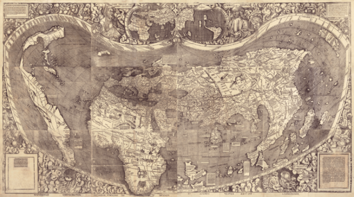
When the Freiburg cartographer Martin Waldseemüller was working on a new edition of Ptolemy's Geographia, his colleague, the poet Matthias Ringmann, had just read Vespucci's travelogues and mistakenly believed him to be the discoverer of the New World. Ringmann wrote the pamphlet accompanying the map drawn by Waldseemüller, which was published together with it on April 25, 1507, under the title Cosmographiae Introductio. In it he wrote:
"[I]t is not clear to me why (this continent) should not be called 'Amerige,' that is, the land of Americus or 'America,' after the discoverer Amerigo, a man of clever mind: for both Europe and Asia are names derived from women."
- Matthias Ringmann: Cosmographiae Introductio. 25 April 1507
Copies of the map spread faster than Waldseemüller could correct the error. In his largest map work of 1513, the name "America" no longer appeared, instead he pointed out that the continent had been "discovered by Christopher Columbus on behalf of the King of Castile". Until his death, he wanted to call "the newly discovered continent 'Brazil' or 'Parrot Country'". Already a few years after the publication of this map the experts spoke exclusively of America, probably because this was a successful word creation. Thus the Schöner Earth globe of 1515, the oldest of its kind to depict the southern half of the New World, also gives its name as "America." Later attempts by other cartographers to name the continent after Columbus resulted only in the naming of Colombia. Columbus' heirs only achieved recognition of Columbus as the discoverer of America through a court case.
An alternative theory was put forward in 1908 by the English local historian Alfred Hudd. According to this theory, the name America can be traced back to Richard ap Meryk (anglicized Richard Amerike), a Welsh-English businessman and customs official in Bristol, who paid the navigator and explorer John Cabot large sums of money. Although this theory did not gain acceptance, it is still held by some authors to the present day.
Alternative names of this continent are Double Continent, Western Hemisphere, New World, Overseas (inaccurate), West Fortress (obsolete), Fourth Continent (obsolete; counted from European point of view), West Indies (obsolete, still used today for the Caribbean region). A self-designation of the continent of the Kuna living in Panamá and northwestern Colombia is Abya Yala.
The term "Indians" for the native peoples of America arose from the misconception that the coast reached was part of Asia. In the Iberian world and in colonial America, the continent continued to be called Indias, "The Indies," until well into the 18th century. The English term Indian can mean both "Indian" and "Indians." To distinguish them, Native Americans are usually referred to as American Indians or Native Americans, and in Canada also as Aborigines or First Nations.
America itself is in turn the namesake for the chemical element americium, which was discovered in 1944.

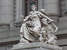
Allegorical depiction of America by Daniel Chester French at the Alexander Hamilton US Custom House, New York City.

World map by Waldseemüller, 1507, single pieces mounted
Subdivision
On the one hand, the American double continent can be divided into the continents North America and South America, on the other hand, Central America is often considered as a separate part. The latter makes sense in plate tectonic terms, since North America rests largely on the North American plate, South America largely on the South American plate and Central America on the Caribbean plate. However, there are deviations from this classification due to political border demarcation, which is not based on plate tectonics.
North America
North America in the narrower sense includes Greenland, Canada, the United States, most of Mexico, and several island states; in the broader sense, the continent includes all of Central America. From Cape Morris Jessup (Greenland 83°39' N. latitude) to the Isthmus of Darién (Panama 8° N. Br.) it is about 10,000 km. The highest peak in North America is Denali (Mount McKinley, 6,194 m), located in Alaska. Lake Superior, with an area of about 82,000 square kilometres, is the second largest lake in the world (after the Caspian Sea).
Central America
The mainland portion of North America south of the Isthmus of Tehuantepec is referred to as Central America. Central America together with the islands of the Caribbean is called Central America. Central America is generally not considered a separate continent, but for the most part is considered part of North America. Central America includes the southern part of Mexico, Belize, Guatemala, El Salvador, Honduras, Nicaragua, Costa Rica, and Panama on the mainland; on islands are the states of Bahamas, Cuba, Jamaica, Haiti, Dominican Republic, St. Kitts and Nevis, Antigua and Barbuda, Dominica, Barbados, St. Lucia, St. Vincent, and Grenada, as well as overseas territories of other states, notably the Turks and Caicos Islands, Puerto Rico, Virgin Islands, Anguilla, St. Martin, Saba, Sint Eustatius, Saint-Barthélemy, Guadeloupe, Martinique. Depending on the delimitation, Trinidad and Tobago as well as the larger northern part of Mexico are also included in Central America for cultural reasons.
In Central America there are many active volcanoes on the Pacific coast. Lake Nicaragua has several hundred islands, some of which are also active volcanoes. This lake was formed by volcanic separation from the Pacific Ocean, which has created unique freshwater varieties of sharks and swordfish. In Central America lies the Panama Canal.
South America
South America includes Colombia, Venezuela, Guyana, Suriname, Ecuador, Peru, Bolivia, Chile, Argentina, Uruguay, Paraguay and Brazil on the mainland, as well as Trinidad and Tobago off the north coast, which is often counted as part of North or Central America, and the overseas department of French Guiana on the mainland, the Dutch islands of Aruba, Bonaire and Curaçao off the north coast, and the Falkland Islands in the southeast of the continent, which are disputed between Argentina and Great Britain. Paraguay and Bolivia are the only landlocked countries in all of the Americas.
More than half of South America is tropical. In the western area, the largest mountain range in the Americas, the Andes, dominates the landscape. The highest mountain in both South America and the entire double continent is the glaciated Aconcagua, 6,962.97 meters high, located near the Chilean border in the Argentine province of Mendoza. The Andes were formed by the subduction of the so-called Nazca plate under the South American plate. Along the tectonically very active western coast is a chain of volcanoes, which runs further south to the volcanic and geyser tundra called Tierra del Fuego.
Between the Andes and the Pacific Ocean in what is now northern Chile lies the extremely arid Atacama Desert. Within the Andes, despite its altitude of over 3,000 m above sea level and the correspondingly cool and dry climate, lies the populous highlands of the Altiplano around Lake Titicaca, the largest lake in South America.
To the northeast is the mountainous region of Guiana and south of that the Amazon basin with the Amazon River, its countless tributaries, fertile floodplains and virgin forests. The Amazon carries one fifth of the fresh water flowing into the sea. The basin is bordered to the south by the highly weathered Brazilian mountains.
Economic region
The division of the world into three economic areas is based on the economic triad with a region with Europe as the center, Asia-Pacific (Far East/East Asia including Siberia and up to Australia, APAC, JAPA, APJ for short) with Japan and China as the vanguard, and the two/three Americas. Further regions are then added to these industrialized centers, whereby the allocation of countries in the sales departments of the various companies is not uniform.
Americas (AMER for short, or NCSA: North, Central and South America) includes:
- NORAM (also NA, NorAm): North America, in a sense corresponding to NAFTA with Canada, USA & Mexico.
- LATAM (aka LAC): Latin America & the Caribbean
- NALA: North America & Latin America - in the case that parts of the Caribbean are included in EMEAC (Europe, Middle East, Africa, Caribbean) as an extension of EMEA.

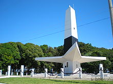
Cape Ponta do Seixas near João Pessoa marks the easternmost point of South America
Questions and Answers
Q: What are the two continents that make up the Americas?
A: The continents that make up the Americas are North America and South America.
Q: What percentage of the Earth's total surface area do the Americas cover?
A: The Americas cover 8.3% of the Earth's total surface area.
Q: What percentage of the Earth's land area do the Americas cover?
A: The Americas cover 28.4% of the Earth's land area.
Q: Which countries do most people consider to be part of North America instead of South America?
A: Most people consider the countries in Central America to be part of North America instead of South America.
Q: What is the most populated country in the Americas?
A: The most populated country in the Americas is the United States.
Q: What does the word "American" usually refer to?
A: The word "American" usually refers to a person or a thing from the United States.
Q: Are people and things from anywhere in the Americas sometimes called "American"?
A: Yes, people and things from anywhere in the Americas are sometimes called "American".
Search within the encyclopedia