Federally Administered Tribal Areas (FATA) — Pakistan's former tribal territories
FATA were a semi-autonomous region on Pakistan's northwestern frontier comprising seven agencies and six frontier regions. Their special status ended with integration into Khyber Pakhtunkhwa to extend Pakistani law and governance.
Overview
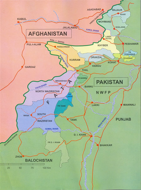
The Federally Administered Tribal Areas (FATA) were a distinct administrative region along Pakistan's northwest frontier, bordering Afghanistan. Historically governed under a separate legal and political framework, FATA covered roughly 27,220 km² (10,507 mi²) and contained sparsely governed tribal areas and small towns. The region's administrative center was Miran Shah, and it lay outside Pakistan's four regular provinces while remaining under federal authority (Pakistan).
Image gallery
9 Images


Administrative structure
FATA was divided into seven Agencies and six Frontier Regions. Each Agency functioned as a large district with its own capital and a Political Agent appointed by the federal government. The Agencies were:
- Bajaur
- Mohmand
- Khyber
- Orakzai
- Kurram
- North Waziristan
- South Waziristan
The six Frontier Regions were small buffer areas administered in conjunction with neighbouring districts of Khyber Pakhtunkhwa.
Legal and political characteristics
For decades FATA operated under a distinct set of rules, most notably the Frontier Crimes Regulation (FCR), which allowed collective punishments, limited appeal rights and decision-making through tribal jirgas (councils). Residents had representation in the national parliament but limited access to the provincial political and judicial systems that applied elsewhere.
Integration and reform
National debate over development, security and civil rights culminated in a major constitutional change that integrated the tribal territories into the province of Khyber Pakhtunkhwa. This process ended FATA's separate legal status and aimed to extend Pakistan's regular laws, courts and administrative services to the area. The reform included dismantling the FCR, creating transitional governance arrangements and planning for infrastructure, education and health improvements.
Historical context and contemporary importance
FATA's history is shaped by tribal society, cross-border ties with Afghanistan and strategic significance during colonial and post-colonial eras. The region attracted attention for counterinsurgency and counterterrorism operations in the 21st century, which drove large-scale displacement and reconstruction needs. Integrating FATA into provincial structures is widely regarded as a long-term step toward political inclusion, rule of law and economic development for local communities.
For further reading on related administrative and geographic details, see government resources and regional overviews (area data, size in miles).

Administration breakdown
The administration of the tribal areas distinguished two categories, depending on the size and population level. The areas in the "Agency" category had their own administrative headquarters and enjoyed greater autonomy. The areas in the "Adjoining Tribal Areas" category were administered from the respective district capital in Khyber Pakhtunkhwa, after which they were also named:
| tribal agency | km² | Population | Administrative headquarters |
| 1.290 | 596.700 | Khar | |
| Khyber Agency | 2.576 | 534.400 | |
| Kurram Agency | 3.380 | 441.600 | Parachinar |
| 2.296 | 331.600 | Ghallanay | |
| North Waziristan Agency | 4.707 | 357.900 | |
| Orakzai Agency | 1.538 | 223.900 | Kalaya |
| South Waziristan Agency | 6.620 | 413.900 | Wana |
| Adjoining Tribal Area (Frontier Region) | |||
| Tribal Area Adj. Bannu District | 0.745 | 019.600 | Bannu |
| Tribal Area Adj. Dera Ismail Khan District | 2.008 | 039.400 | D.I.Khan |
| Tribal Area Adj. Kohat District | 0.446 | 090.800 | Kohat |
| Tribal Area Adj. Lakki Marwat District | 0.132 | 007.000 | Lakki |
| Tribal Area Adj. Peshawar District | 0.261 | 053.900 | Peshawar |
| Tribal Area Adj. Tank District | 1.221 | 027.300 | Jandola |
Geography
The tribal areas bordered the provinces of Khyber Pakhtunkhwa (east), Punjab (southeast) and Balochistan (south), as well as Afghanistan (west).
Related articles
Author
AlegsaOnline.com Federally Administered Tribal Areas (FATA) — Pakistan's former tribal territories Leandro Alegsa
URL: https://en.alegsaonline.com/art/33864
Sources
- statpak.gov.pk : "Area, Population, Density and Urban/Rural Proportion by Administrative Units"
- fata.gov.pk : "Population"
- commons.wikimedia.org : Federally Administered Tribal Areas