Extremadura: geography, history and culture of the western Spanish region
Extremadura is an autonomous community in western Spain, comprising the provinces of Cáceres and Badajoz. Known for Roman heritage, dehesa landscapes, jamón ibérico and a rich rural culture.
Overview
Extremadura is an autonomous community of Spain situated on the western side of the Iberian Peninsula. Its official capital is Mérida, a city noted for extensive Roman archaeological remains. The region is sparsely populated compared with Spain's main urban areas and retains a strong rural character, with wide plains, pastureland and pockets of well-preserved historic towns.
Image gallery
8 Images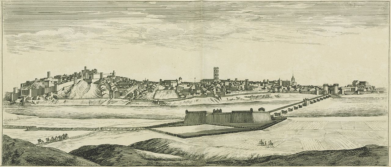


Administrative divisions and major cities
Administratively Extremadura consists of two provinces: Cáceres in the north and Badajoz in the south-west. Principal municipalities include Mérida, Cáceres, Badajoz city and Plasencia, each serving as local cultural and economic centres. The provincial structure reflects historical patterns of settlement and land use that continue to influence local governance.
Location, borders and landscape
The region is bordered to the west by Portugal, to the north by Castile and León, to the south by Andalusia and to the east by Castile–La Mancha. Extremadura's terrain includes the river valleys of the Tagus and the Guadiana, the rolling pasture known as the dehesa, and mountainous areas such as the Sierra de Gata. These varied landscapes support important biodiversity and several protected natural parks.
History and heritage
Human presence in Extremadura dates back to prehistoric times; later periods left a marked imprint, notably Roman rule. Mérida (Augusta Emerita) preserves theatres, bridges and other monuments that are valued examples of Roman urbanism. The medieval historic centre of Cáceres is also celebrated for its mix of Roman, Islamic and Christian architecture. During the Age of Discovery, many explorers and conquistadors originated from Extremadura, a historical fact that connects the region to broader Atlantic and colonial histories.
Economy, agriculture and cuisine
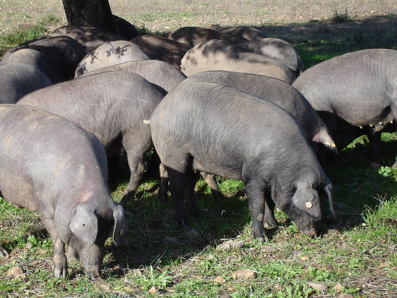
The economy remains strongly linked to agriculture, livestock and forestry. The dehesa supports livestock such as the Iberian pig, whose acorn-fed hams (jamón ibérico) are a notable regional product. Olive groves, vineyards, cork oak management and small-scale cereal farming are also common. Tourism focused on nature, heritage and gastronomy has grown in recent decades as a complement to traditional activities.
Culture, conservation and contemporary issues
Extremadura preserves distinct folk traditions, festivals and culinary practices rooted in rural life. Regional conservation efforts protect species and landscapes in places such as Monfragüe and other reserves. Like many rural European regions, Extremadura faces challenges including population decline in remote areas and the need to balance development with heritage and environmental protection, but it remains valued for its landscapes, historical sites and gastronomic specialties.
- Key rivers: Tagus and Guadiana.
- Protected areas: Monfragüe and other natural parks.
- UNESCO and heritage sites centered in Mérida and Cáceres.
- Signature foods: jamón ibérico, olive oil and traditional stews.
For further reading about administrative details and travel information, consult regional resources and dedicated heritage guides via official portals and cultural institutions (regional overview, province of Cáceres, province of Badajoz).


Geography
Extremadura has an area of 41,634 km², representing 8.2% of the Spanish land mass. It is larger than Switzerland, Belgium or the Netherlands and the fifth largest autonomous community in Spain. Extremadura is made up of the 19,868 km² province of Cáceres and the 21,766 km² province of Badajoz.
The extreme north of the region is mountainous. The western foothills of the central system of the Iberian Peninsula form several mountain ranges and valleys that connect to the Castilian Sierra de Gredos. The highest mountain is Calvitero, at 2,399 m, on the border with the province of Salamanca. These areas are rich in water and fertile; well known are the cherries from the Valle del Jerte or peppers from the region of La Vera.
South of the river Tagus begins drier land with wide plains, known for viticulture (D.O. Ribera del Guadiana), but especially for its holm oak groves (Spanish dehesas), where the black Iberian pig (cerdo ibérico) is kept, which feeds mainly on acorns. The special breed and diet - both of which are subject to strict regulations to protect the "ibérico" product designation - give the famous Jamón Ibérico (air-dried ham) its special taste and high quality.
In addition, many rare, endangered animals still live here, such as the bobcat, the great bustard, a large ground bird, which is also the heraldic animal there, as well as the crane, the black stork and also the wolf.
In the region south of the rivers Tajo and Ebro, in addition to holm oaks, there are also cork oaks, the barks of which are mainly processed into corks for the wine industry in the Portuguese province of Alentejo.
The Tagus flows through Extremadura in the north and the Guadiana in the south.
Climate
Extremadura is characterized by a Mediterranean climate. Only in the north, in the mountainous region, continental weather conditions prevail, causing a climatic division of the region. The soil in the north is rich in water and fertile. In the region south of the Tagus, it is dry, which has created large areas of almost untouched nature.
Such a climate is characterised by mild, rainy winters and dry summers. The average annual temperature of Extremadura is 16-17 °C. In the north, the average annual temperature is 13 °C, while in the south it is 18 °C.
Rainfall in the region ranges between 450 and 500 mm per year. Summer brings average temperatures around 26 °C, which can rise to 46 °C.
Related articles
Author
AlegsaOnline.com Extremadura: geography, history and culture of the western Spanish region Leandro Alegsa
URL: https://en.alegsaonline.com/art/33033