Amazon River (Rio Amazonas)
The Amazon River is the world's largest river by discharge, flowing from the Andes east across South America's tropical forests to the Atlantic; central to biodiversity, culture, transport and the global water cycle.
Overview
The Amazon River (commonly called Rio Amazonas in Portuguese and Río Amazonas in Spanish) traverses the heart of tropical South America. Its main channel runs from highland headwaters in the Andes eastward across the continent and discharges into the Atlantic near the equator. The river system drains an immense area of rainforest, savanna and upland, and supplies a disproportionately large share of the planet's freshwater runoff.
Image gallery
4 Images


Key characteristics
The Amazon is noted above all for the volume of water it carries. Its discharge exceeds that of most other rivers combined and contributes roughly one fifth of the fresh water entering the world’s oceans, a fact reflected in major hydrological summaries (global river flow). The river's basin is the largest on Earth and spans numerous political boundaries; for maps and basin descriptions see drainage basin resources. Seasonal rains and the flood pulse can expand the river and its floodplain to enormous widths—hundreds of kilometres in some floodplain reaches—creating vast, seasonally inundated forests.
Physical components and ecology
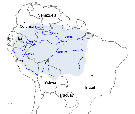
The Amazon system includes a dense network of tributaries, floodplain lakes and wetlands. Major tributaries include rivers that arise in the Andes and lowlands and deliver sediment, nutrients and water that sustain aquatic habitats and forest productivity. Floodplain habitats are typically divided into várzea (whitewater, nutrient-rich) and igapó (blackwater, nutrient-poor) environments, each supporting distinctive plant and animal communities. The basin is one of the most biodiverse regions on Earth, home to countless fish, bird, mammal and plant species, many of them endemic.
Human history and uses
Indigenous peoples have lived throughout the Amazon basin for millennia, developing fishing, farming and river-based transport adapted to seasonal cycles. Since European contact, the river has served as a major transport corridor into interior regions and a focus for exploration, settlement and resource extraction. Today the Amazon remains vital for river transport, fisheries, local livelihoods and, increasingly, for regional economies through timber, agriculture and mining, while also being considered for hydroelectric development in some tributary basins.
Importance and contemporary challenges
The Amazon influences regional and global climate by recycling moisture and storing carbon in forests and soils. Its freshwater plume also affects coastal ecosystems and ocean circulation near the equator. At the same time, the basin faces pressures from deforestation, infrastructure projects, gold mining, pollution and changing precipitation patterns. These threats alter hydrology, reduce habitat and can undermine the livelihoods of riverine communities and the basin’s role in the global carbon and water cycles.
Notable distinctions
- The Amazon is the largest river by volume and has the planet’s largest drainage basin; it provides roughly one fifth of global river discharge to the oceans (see global flow references).
- There is historic and ongoing debate over which river system is longest—the Amazon or the Nile—depending on how headwaters and tributaries are measured.
- Because of its size and breadth, the river and its floodplain are sometimes referred to poetically as “the great river” or even simply "the sea" by local inhabitants.
The Amazon remains a subject of intense scientific study, conservation concern and cultural significance. For maps, basin data and research resources, consult hydrological and regional studies linked through authoritative portals (drainage basin overview, Brazilian resources, Spanish-language resources).
Name
Originally, the river had different names in different sections, which were used by the respective indigenous riparians. One such original name has survived to this day in the Portuguese name Solimões, which is officially used for the Brazilian upper reaches up to the confluence with the Rio Negro. The Spaniard Vicente Yáñez Pinzón, who was the first European explorer of the river, named it Río Santa María de la Mar Dulce, or Mar Dulce ("Freshwater Sea") for the freshwater found in the open sea off its mouth. Later, after 1502, the river was known to the Portuguese as Rio Grande ("Great River"), a name also used for several other rivers in Brazil. The Spanish began calling it Río Marañón in 1513, a name that is not entirely clear whether it comes from an indigenous language or derives from the Spanish word maraña, which means "tangle" and may be a reference to the confusing confusion of the many branching watercourses. This name was prevalent in Spanish-speaking geography for a long time and has survived in the name of the northern headwaters and the Peruvian province of the same name, Marañón, as well as in the name of the Brazilian state of Maranhão on the lower reaches. It is also possible that the name of the estuarine island Marajó derives from the same linguistic root.
The origin of the name Amazon is not fully understood. It is usually attributed to the fact that on the voyage of Francisco de Orellana (who set out from Ecuador in 1540 with the Gonzalo Pizarro expedition and reached what is now the Amazon River in January 1542 and was the first to cross it to the mouth of the Atlantic), the Spanish explorers saw Indian warrior women and therefore named the river after the legendary Amazons. The chronicler of the expedition, the Dominican Gaspar de Carvajal, describes in his travel diary the encounter, allegedly in June 1542, with "very fair-skinned and tall women, wearing their very long hair braided around their heads and very stoutly built." They fought fiercely and decisively "like leaders at the head of the Indians" and "aimed only at the eyes." Later, the Spaniards interrogated a captured Indian who reportedly told of the peculiar habits of these female fighters. As a result, Orellana had decided to name the river "Stream of the Amazons."
This possibly legendary explanation for the naming, which corresponded to the common ideas of the Europeans at that time, according to which Amazons and other extraordinary beings and monsters lived in America, was already known among sailors and explorers a few decades after Orellana's voyage of discovery. It was first handed down by Gonzalo Fernández de Oviedo († 1557), who personally talked with Gaspar de Carvajal about the experiences and wanted the designation of the warrior women as "Amazons" to be understood explicitly "in a figurative sense", and later spread by Richard Hakluyt (1589), Walter Raleigh (1596) and by the Inca Garcilaso de la Vega (1609).
According to other hypotheses, the name could go back to the Indian word Amassona, which means "ship destroyer" and which some Indian peoples used to describe the tidal waves occurring in the lower reaches of the Amazon (see Pororoca).
In German the name Amazonas became established in the 19th century, until about 1800 the name Amazonenfluss and until the early 20th century also the name Amazonenstrom were common.
The Amazon River, in turn, gave their names to the Amazon Basin as well as several administrative units of the same name in Brazil, Venezuela, Colombia and Peru. The term Amazonia, a rather fuzzy term for the tropical rainforest and Amazon region as a whole, also derives from the name of the largest South American river. The Amazon Basin or Amazonia are often mistakenly called Amazonas.

Hydrology
Water flow and sediment load
At its mouth, the Amazon delivers an annual average of about 206,000 m³/s of water (6600 km³/a) to the Atlantic Ocean; this is 17 percent of the world's ocean inflows. The influence of the tides still extends some 800 kilometres upstream to the city of Óbidos, which lies at an almost 90-metre-deep narrows of the river (with a width of approx. 2 km).
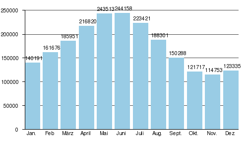
Mean monthly discharges (in m³/s) at the Óbidos gauge
(height: 1 m, catchment area: 4,640,300 km², based on values from 1928 to 1996)
Every year, 1.2 billion tons of sediment are transported past the town of Óbidos, about 800 km from the mouth. About 75 percent of this reaches the Atlantic Ocean, the remaining 25 percent is deposited on the lower 800 kilometres of the river.
Bifurcations and waters of changing flow direction
The western Amazon lowlands are part of the foreland depression east of the Andes. The transitions to the adjacent plains to the north and south east of the Andes are so imperceptible that continent-wide river bifurcations have occurred in both cases. In the north the Brazo Casiquiare branches off from the Orinoco, and in the south there is a bifurcation at the boundary with the Río Paraguay basin.
In the Amazon lowlands, due to the low gradient (30 metres over the last 800 kilometres), the lower reaches of the tributaries are often connected by natural channels. These waters can have changing flow directions depending on the water level of the neighbouring rivers. Similarly, the tidal channels called Furo near the town of Breves separate the 49,000 km² island of Marajó from the continent. One passage is suitable for ocean-going vessels and provides an important link between the Amazon and the port of Belém.
Marine influences
Below the narrows of Óbidos, the influence of high and low tide already begins, but mixing with salt water does not take place in the estuary-like widening stream channels, in contrast to the neighboring sea bays of the Rio Pará to the southeast in the estuary area of the Tocantin. The reason for this lies in the water masses of the stream, which are pushed northwestward by the Atlantic equatorial current, but nevertheless push the salty water surface far beyond 100 km into the open sea.
A few times a year, a tidal wave up to four metres high rolls up the Amazon and certain tributaries several kilometres upstream with the onset of the tide from the Atlantic. It is called Pororoca after the term poroc-poroc, which in the Tupi language means something like "great destructive noise". The prerequisite for the occurrence of this phenomenon is the coincidence of a low water level (during about 3 weeks around February/March) in the Amazon, which has a low gradient, with a spring tide at new or full moon. Feared by local residents for its destructive power, the Pororoca attracts surfers from all over the world.
Water colours
The Amazon has a light brown colour, which comes from the sediment load that is carried in particular from the headwater rivers located in the Andes. 90 percent of the sediment carried by the Amazon is brought in by the Madeira, the Ucayali and the Marañón. These rivers are called white water rivers.
However, some tributaries come from crystalline areas with low sediment loads, for example the Rio Tapajós or the Rio Xingu. They are called clear water rivers.
Some of the rivers with transparent water appear dark brown like the Rio Negro because of the humic acids dissolved in them. They are called blackwater rivers.
At the confluences of differently coloured rivers, the different colours of the water masses can sometimes be seen for kilometres.


Questions and answers
Q: What is the name of the world's longest river?
A: The world's longest river is the Nile River.
Q: Where does the Amazon River originate from?
A: The Amazon River originates from the Andes Mountains in Peru, on the western edge of South America.
Q: How much water does the Amazon carry compared to other rivers?
A: The Amazon carries more water than the next eight largest rivers of the world combined and has the largest drainage basin in the world, accounting for about one fifth of the world's total river flow.
Q: Is it true that during certain times, parts of it can exceed 120 miles (190 km) in width?
A: Yes, during its wet season, parts of it can exceed 120 miles (190 km) in width.
Q: What language is Rio Amazonas translated into?
A: Rio Amazonas is translated into Portuguese and Spanish.
Q: Does this make it a sea or a river system?
A: Because of its size, it is sometimes called The Sea but it is not actually a sea; rather, it is a river system.
Q: In which direction does this river flow?
A: The Amazon River flows eastward into the Atlantic Ocean near the equator.
Related articles
Author
AlegsaOnline.com Amazon River (Rio Amazonas) Leandro Alegsa
URL: https://en.alegsaonline.com/art/3258
Sources
- britannica.com : "Amazon River"
- cienciaesaude.uol.com.br : "Amazonas supera o Nilo como rio mais longo, dizem cientistas"
- opovo.com.br : "Amazonas é o rio mais extenso"
- elpais.com : "El río más largo del mundo"
- news.nationalgeographic.com : "Amazon Longer than Nile River, Scientists Say"
- news.nationalgeographic.com : "Explorers Pinpoint Source of the Amazon"
- palkiewicz.com : "The Amazon River without secrets"
- fogonazos.blogspot.com : "Pororoca: surfing the Amazon"
- encarta.msn.com : "Amazon (river)" · web.archive.org
- upf.com : "Urarina Society, Cosmology, and History in Peruvian Amazonia"
- uk.encarta.msn.com : "Amazon - MSN Encarta"
- ultramargroup.com : "Peru port information"